DOC NOSS-Victorio Peak OR The Caballo Mountains

Been thinking about this for where the drone won't suffice. So many caves in sheer locations. Don't they make a collapsible escape-type ladder? Easier to hike with. Stash a few for me. October weather is just around the corner!
View attachment 1356493

I have a 32 ft aluminum extension ladder stashed up near sardine canyon. anyone seen it lately? your welcome to use it but please put it back where you found it when done.
its painted flat black.
thanks
wr
 

They (whoever) dug down through a bunch of decomposed granite only about 6-8' right at the base of the rabbit/burro "ears" north of longbottom. They were also drilling with a rig due south at one point across Longbottom after that. Maybe more has gone on. Have not revisted that particular place in a while.

Lots of digging in solid limestone or, at the other end of the spectrum, crumbly loose stuff in those mountains. Not sure why this makes sense, especially the limestone. I can see mucking out fill, but why bother blasting through limestone when there's got to be a way in (to wherever).

Some old letters I've been let read say Willie's cave is only 15 foot deep and a slight incline, but very well hidden. Matches well with one of the Tollman folklore collection project stories that's supported by long-gone (but documented!) markers.

I think the skull of a redhead was found not too far from those ears at one point way back. There's some murder thing I can't remember where the car was found up in ABQ.

A lot has happened at the "rabbit ears" (which I dont think are) in the last couple of years including a death from a cave in while digging.
I am in agreement with you that it makes more since to attempt to locate a "walk in" type entrance (although it might need excavation to enter since being hideen) than to try and dig vertically down thru unstable rock.
If gold bars were transported into the vault by burro and/or slaves, i dont think they did it thru a 100 foot vertical hole. I think they had horizontal entrances.

I would like to hear more about the letters you have read about Willies cave. Do you mean the entire cave was only 15 feet long? I also believe it is extremely well hidden entrance.
What it the Tollman folklore? Do you know where those markers are?

thanks for your info.
wr
 

32.928968°, -107.241367°

Not on the wrong side of the planet, but definitely not the site of the "cabin" and now-dried springs, as I have ever been told (by a youger relative of a goat-herder that used to camp at Cleto about 70 years ago <he camped there 70 years ago; I did not hear of it then!>) That's a hand-dug fluorite mine. Plus, anchor point for the cable up cable (bat) canyon, if I recall. Maybe the name was co-opted as the closest named place to the Noss-related basecamp that I assume is the object of interest?
 

Last edited:
Trade?

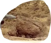
Can I trade you this picture of a turtle-like thing from NM for a more specific explanation of what 4-numbers mean?

E.g., your 1732 or some similar example,,, or even an "A.E.F.E. 1800" with a feathered arrow?

I agree with you about trees entirely.

And, I say there's never any distance too great to travel for true fun! What else is there?

you drive that far ?
Mich to NM ?

long ways for fun .

First Clue on treasure in the area

If you see a symbol or blaze

walk right up to it , put your back against the symbol
look straight out ahead of you

what do you see ?

possibly the next clue or trail marker ?

Standing or sitting stones atop of boulders , the clue for these are , the fewer of them on a boulder , and or the smaller
the closer you are to the cache

if you get to a boulder with a single small stone about the size of a Man's Hand , you are right on top of the cache

if the stone is shaped like an arrow head , it is pointing at the cache or mine within yards of it .

NEVER ,,,, never assume any symbol can be translated using Spanish interpretations .

Take the word Boveda , which was on a Marker stone my Dad found .

it is NOT Spanish .
it's a Dialect of French which is spoken , or was spoken , in the South East of France , same place
King Richards Mother was from .

Numbers in sets

four numbers set together such as 1732 ,,, is NOT a Date ,,, None of the people who set these vaults
would bother to carve or paint , write a Date , Map Rocks and markers are not Royal Documents
they do not need a Date .
the Numbers are increments , either distance , or ,,,,
but not dates .

Lines Painted on Bluffs , Cliffs , cave walls or Boulders

these lines represent TRAILS ,,, no matter how curvy the lines are , do not mistake them to mean River or Creek .
they are not water symbols .

Dots in the center of a Circle

That symbolizes a Boulder set atop another Huge Boulder

it is NOT a Cave symbol , You look for a Huge Boulder with a Rock setting on top ,
climb up on it ,, LOOK ,,, see what you see .

Elevated Stones are four smaller Rocks ,,, these are often referred to as Tortugas or Turtle Stones

what do they mean ?

They mean for you to go up in elevation .
so you go UP from that Monument .

Tree with a carving on it

do not pay attention to them , no Vault Builder would ever leave a Marker carved into a Tree
Trees Burn
they place markers on items they know will last , Trees are Vulnerable .

For those who argue that the KGC agents carved on Trees ,, believe what you will , I know better .

next , my dads Map and an Actual Treasure site on it , that the last time I checked , was still undisturbed .
 

Attachments

  • turtledolmen.JPG
    turtledolmen.JPG
    40.5 KB · Views: 190
A lot has happened at the "rabbit ears" (which I dont think are) in the last couple of years including a death from a cave in while digging.
I am in agreement with you that it makes more since to attempt to locate a "walk in" type entrance (although it might need excavation to enter since being hideen) than to try and dig vertically down thru unstable rock.
If gold bars were transported into the vault by burro and/or slaves, i dont think they did it thru a 100 foot vertical hole. I think they had horizontal entrances.

I would like to hear more about the letters you have read about Willies cave. Do you mean the entire cave was only 15 feet long? I also believe it is extremely well hidden entrance.
What it the Tollman folklore? Do you know where those markers are?

thanks for your info.
wr

Sad to hear about the death. We need more treasure hunters, so safety first...

Yes, the letters said only 15' deep. Did not say where. Said well hidden, but no additional clues. I hope it's well hidden else we're just getting our extra 10% of 110% out hiking for the fun of it! 15' deep is kind of tantalizing, but make more sense than way inside the mtn. Carry even 40 lb of rocks up and over stuff, and it gets real old, real fast. Of course, my old timer friend says that slave labor was cheap and plentiful, so?

Tollman recorded some folklore in a book. Interviewed residents from Hatch up to TorC (back in the late 40's?). Lot's of old-timers with stories varying from pure spiritualist stuff to more modest tales of note. Unfortunately, markers long-gone. Most that I've been told or have seen pictures of or have held were destroyed or removed in the 60's. Now may need to consider that only way is to stumble across the actual opening(s). Wonder what it would take to hire 1,000 people for one day to search Burbank? Modern approach is to get them to do it for free as some sort of crowd-sourced thing. Maybe a reality show? Have to tell them that they are searching for some endangered one-eyed stupid lizzard so they can feel fulfilled and relieve their guilt in a non-religious (but essentially still religious) way. Maybe they can search for the mountain sheep that are long dead! I released a goldfish on the sidewalk once, so it must still be there...

Anyways, sorry I don't know more. In fact, I tend to avoid that area due to the over-stomped aspect. One time, some guys, who must have been watching from across the river, followed me and a buddy up the road past Gordon's, but then sekdaddled when we ruined their plans of catching us at some "special place" when we just turned around after a quick look at the surrounding terrain. Not that there's any patented land up that way (as far as I know). Sort of weak sauce.
 

Not on the wrong side of the planet, but definitely not the site of the "cabin" and now-dried springs, as I have ever been told (by a youger relative of a goat-herder that used to camp at Celto about 70 years ago <he camped there 70 years ago; I did not hear of it then!>) That's a hand-dug fluorite mine. Plus, anchor point for the cable up cable (bat) canyon, if I recall. Maybe the name was co-opted as the closest named place to the Noss-related basecamp that I assume is the object of interest?

Can you provide an alternate GPS location then? I have sources that say that is the correct place.
 

Au, it is an interesting geological spec.man. There are several interesting points about it that convince me that it is a work of nature, for one the eyes are different, and what about that interesting lil carving to it's right, what is it according to your imagination ? the upper materiel si bleeding dow along the nose dow into the mouth. atc.
 

Can you provide an alternate GPS location then? I have sources that say that is the correct place.

I was told it (Cleto Spring) was to the north, not terribly far, but definitely not at the present old mining ruins. I did not go there. Hiked uphill past where he said it was to go the mines in the iron layer (I'd use an ATV next time!) Could be that they re-used the name of the spring for that location (mining ruins) since it was the closest old landmark, my guy could be wrong (I doubt this given his family history, etc. in the area), or I could be confused!
 

I am at work so can't check at the moment, but if memory serves there is a map in Tales of the Caballos" that shows where Cleto Springs is located. I believe that is where I got my location from. I will have to verify later when I get home. It may be in the one of the Gold House Trilogy books as well.
 

Can you provide an alternate GPS location then? I have sources that say that is the correct place.

UM:
IMO the coordinates you are discussing, are not the location of Cleto springs.
The location you give is the old mine/cabin and windmill area as nmth suggests.

I have located the old Cleto springs exactly where my source said it would be. Also found the old road going to it. Now obscure and does not show on GE.
Of course it is dry now. There are several very large very old juniper trees surrounding the old spring area.

My source says Doc did not camp directly at Cleto springs but camped at 3 different sights somewhat close to the spring and moved round these 3 sites.
My source claims Letha showed him these 3 sights personally long ago.
I am in the process of exploring the Cleto springs area and the 3 camp sites.

wr

Please provide the GPS to the site you claim the spring is located. Thanks.
 

whiskeyrat and nmth
Ruth tolman was a psycologist, and worked many years for the goverment, she studied difference in psycology of
men and women, criminal minds, and PTSD if that is what they called it after ww2, her husband Richard C. Tolman
was a chemist and physicist and an adviser on the Manhatten project at Alamosa New Mexico so this is what probably
brought her to New Mexico.

She conducted interviews of people around the Caballo's, but my question has been why?????
was she simply trying to study the twisted minds of treasure hunters or did she have some information she was trying
to follow up on.
 

During her marriage and for many years after her husband died she carried on an affair with her husbands good friend
J Robert Oppenheimer '' The Father Of The Atomis Bomb '' was Hot Springs a getaway for the atomic lovers.
maybe conducting these interviews was just a way to bide her time-stay busy if you will, she wrote several psyc books
and some books on young ladys edicate, coming of age and such.
she had a chapter in some sort of publication on south western folklore which included some of these interviews
I cant find the whole publication only her chapter '' Treasure Tales of the Caballo's '' and i dont think it is complete
 

What i wouldnt give to have all her interviews.
For the most part she only gives partial names, and initials to protect these people.
she interviews some '' Buckalew's '' whose story sounds like a cross between the Willie Douthit and Jack Reynolds storie's, she interviews some goat herders
sha has several interviews with a '' Lady M '' I am sure this is Margaret Perrone AKA Margaret Harris.
As I have said the original story I read about Margaret Perrone differs in several ways from what is on TNET and what was in her obituary i just wishedi
could find it I feel it may be one of Ruth Tolmans interviews.
 

whiskeyrat and nmth
Ruth tolman was a psycologist, and worked many years for the goverment, she studied difference in psycology of
men and women, criminal minds, and PTSD if that is what they called it after ww2, her husband Richard C. Tolman
was a chemist and physicist and an adviser on the Manhatten project at Alamosa New Mexico so this is what probably
brought her to New Mexico.

She conducted interviews of people around the Caballo's, but my question has been why?????
was she simply trying to study the twisted minds of treasure hunters or did she have some information she was trying
to follow up on.

T or C had (and still has) a wealth of ground to probe (no pun intended) for a psychologist. Hoo boy. I suspect that Tolman was not so much interested in her subjects' beliefs, but more so in why they held the beliefs so strongly.
 

Instant wealth syndrome is at work. The idea that a treasure is out there just waiting for you to find it. In NM where poverty is very prevalent, especially in small towns and rural communities, such an idea would find fertile soil to take root. When you have nothing, a fantasy of instant wealth is an easy thing to cling to. Throw in old legends and stories of previous cultures hiding such treasure, and also of people finding treasure in the past, and you get what you have in the Caballos (and in many other areas of NM as well).
 

Last edited:
BTW if you leave Las Cruses on hwy 70 heading for White Sands, as you "top out" look to the left (North) and see the road with a nice fence around it. The trucks are hauling waste from the mine that they were working in the 80's-90's. Yes it was a gold mine. Just something to think about.
 

In several of the old treasure mysteries, there is a certain spring mentioned.

This particular spring is said to "flow both directions". The spring is apparently located on top of a ridge and the water flows both east and west.

It is no longer running water obviously.

Has any one seen such a spring or area where such a spring could have been?

It wont be a spring know, but should still be a ridge with a wash going both directions off of it and perhaps old juniper trees around it indicating an old spring area?????
 

Top Member Reactions

Users who are viewing this thread

Back
Top