DOC NOSS-Victorio Peak OR The Caballo Mountains

Sorry, Don Jose. You can backtrack the Jesuits till the cows come home and you'll find no activity by them in New Mexico until the 19th century. It was Franciscan territory, plain and simple. No churches, no missions, no camps, no secret agreements with the King or the Apaches. As we've discussed before, your Jesuit-Caballo theory suffers from several fatal flaws, none of which could have been covered up in the documents, traditions, records and histories (written and oral) of the Spanish military, the New Mexico governors, the Franciscan church, the Apache nation or the local histories in an area encompassing the El Paso-Janos-Santa Rita territory.

I have no idea what you have found in Mexico that relates to the Jesuits, but trying to patch it into the Noss legends based on that suspicious map is a waste of your time, IMO. I do believe there are caches in the Franklin-Organ-Caballo mountains region, but IMO, wherever they came from, it wasn't the Jesuits.

Dang it, Now i have to think who worked these sites. I guess ill have to look and see if the ancients used the 7 symbol, F symbol and so on. Till i can make a recovery,even then i probably wouldn't know.:dontknow:
 

Caballo notes - reply to old post

That would be cool and I think we'd all like to see your pics. I've posted everything I know about it. Hopefully someone with more details will step forward.

Don't get on here much. However, recent finds have renewed my interest and "belief". Replying to an old post may be bad form, but...

Regarding the Caballos: all to the best of my knowledge and of course my opinion:

1) Rabbit or mule ears north of Longbottom (aka Lead) canyon. Decent copper deposits there, and interesting area for a geology nerd. Spur road goes right to the ears. It's East of Ash spring. Pictures are somewhere, but not at hand at the moment.

2) Tavern was still open last I drove past (a few months ago)

3) Access West side from T or C bridge East of town over the river, OR ford the river at Palomas, OR drop S. of tavern and turn East at the radio towers and work your way over to the underpass on the dirt farm roads.

4) Cable aka Bat Cave Canyon. Not sure I think anything is or was there. Cable was still there years ago in the box canyon but I don't spend much time there. Cleto springs is name I know for the old Noss-related camp somebody else maybe spelled "Clato".

5) Land status on some maps is wrong for the top of the mountain, in particular. Most all the area is BLM. Only private area other than Gordon's cabin and some other obvious ones is on the Shandon placers and it's unsigned, etc.

6) Only claim I found near the known gold zone for my buddy's old friend Don Fingado is at the East end of the Shandon. Could be more.

7) LOTS of interesting stuff all over those mtns, and locals know of SO much that is gone. I suspect that to have found a lot of what I have seen in old pictures, on shelves, and in drawers here and there, etc., recovery could have been a much more realistic prospect. Now, so many busy hands and feet and even a few apparent fakes. There are still lonely corners, some I never hear about from anybody else, that are among the most interesting and compelling.

8) As a matter of general logistics, and in line with so many old maps, I like the Caballos as a lot more practical of a location than VP.

9) That said, there was a practical route E-W through Hembrillo used since antiquity, so maybe I just like the pavement too much.

10) Carry 100 lbs miles across rough ground, dig a hole, clean out a cave, mine some rock, try to move without being seen, etc. and I think it helps understand the original emplacers, as well as the modern recoverers, e.g., Willie, Doc, etc. No substitute. Also, what would YOU do to guarantee your buddies across the ocean could find the right place in a land of nothing without your help a decade or two down the line? - 'cuz you sure as heck were NOT EVER coming back to the Apache-infested wasteland of doom no matter what!

11) Lots of gold nearby. Hillsboro is largest placer in S. half of state, a little in the Organs, plenty in the deep Black Range, but logistically tough to get out. Not to mention the San Mateos, some by Chloride, etc. Lots of Silver, too, and the easy self-fluxing Galena type. Bridal Chamber up over the hill, too. I always feel better hunting for metal when there's a natural source neaby. And Santa Rita, Pinos Altos, the Burros, Mogollon, etc. all up over the pass as well.

12) Note the old Presidio at San Diego crossing has been on the maps for a very long time. Las Cruces was just "Rancheria" if they mentioned it at all. Dona Anas used to be Robledo Hills vs. Robledo Mtns. across the rio. Why a presidio there with such a lonely stretch of nothing between El Presidio del Paso del Norte (vs. de Las Juntas) and Santa Fe? What was there to protect? I see others peg Los Caballos as "del Perillo", but I just don't see that on all the old maps I have - been Caballos for a long time, AFAIK, but I try to have a 1/2 closed mind (would not want to be 1/2 open and have things fall out).

Good luck.

I think it's safe to say that there is likely some basis for believing in the existence of precious metals caches in the Caballos-Organs-Franklins region. If so, it's much less likely, IMO, that the boatload of treasure tales, legends, alleged "secret information", etc. that promote the rumors will ever explain the mysteries. Much of what we read about the caches, and most of what we choose to believe in them, centers around a list of characters who made a name for themselves in the early to mid 20th century (Noss, Dougthit and their cohorts, the many followers and scammers who promoted themselves later - and still do - and the El Chato/LaRue pushers who seem to grace the treasure magazine culture in great numbers).

I suspect Noss and his early cohorts had some knowledge of the truth of the matter, but I also strongly suspect that everything that came to light from his camp was carefully formulated to be disinformative. Noss was no dummy, but he clearly was a lying sociopath, and all the "source material" that came from his family is extremely highly suspect, IMO. It's also my suspicion that the alleged Victorio Peak storehouse was fabricated and promoted by Noss as a means of diverting attention away from possible more authentic sites on the Rio Grande. For those who believe that the US Army removed Noss's treasure from Hembrillo Basin, consider that many believe certain Army brass alleged to have stolen all that Germain gold at the end of WWII may have used Victorio Peak as a convenient venue to launder their booty, not as illegal war spoils, but as "Spanish treasure."

One has to wonder - if the gold caches are real, where did the gold come from in the first place? From hidden, secret, one-in-a-million rich veins in the Caballos, Organs and/or Franklins? Or, from an area with known massive metal deposits including documented recovery of large quantities of gold, spanning two hundred years that we're sure of, and possibly many more before that when the pickings were even richer and easier to recover? I'd personally choose the latter, and speculate that sometime during that long history, someone moved a large quantity of metal to cache sites near the Rio Grande - motives and identities unknown. Moved the gold from where? Follow Emory's report.
 

Last edited:
I appreciate that post sdcfia! And your other recent posts as well. We may not always agree, but I appreciate your logical fact based approach to many topics.
 

SDC, I am still convinced that the Caballos depoitories were left by the Jesuits as a buffer for loading the infrequent Jesuit ships, NP's lil map is correct in it's basic details with things that were not known until recent times, after doc's time.
 

Last edited:
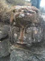
Hello All. I am not sure where to post this, so I guess I will try here. Ran into a picture posted by a work "associate". I thought some here might like to see it, I know I was surprised.
Picture was posted two days ago, on a private page on facebook. Am "borrowing" it here, so you guys can see it too.

Don Real, or someone, possibly, can(?), tell me if this is Mayan or Aztec? If you enlarge the picture, however you are able to, and view it from a few feet away, you can see, besides the obvious face image, the "headdress" w/face, of a serpent, at least it looks like it to me.

Original picture poster claims picture taken/item found in Texas, near unnamed city on Texas/State of Coahuila, Mexico, border.
Don, you can see "green' pants standing behind rock, haha!

2016-09-04 indian Find Texas.jpg
 

nmth, why NP's lil map. it is accurate as to period and locations. and shows a reasonable source for Dore' bars.
 

AUT, a very interesting example of Mother Nature at work. Go to the sides for faulting and other of her work. Sorry my frend, but personally don't believe that it is a work of man, but keep it up.
 

That is interesting that you don't see this as a handworked stone carving...

After all of the pictures in this forum showing what some see as manmade carved works...this is one of the few that actually 'looks' manmade and not natural...To me..

The symmetry of the nose, eyes (and placement), upper lip, etc..
 

The head is handmade and I believe is Mayan . Maybe " Real of Tayopa " was talking about the Sneak head .
 

Hi,I am sorry that Don Fingado isn't around any more. We had our differences on Tayopa, on which I was proven to be correct since I found it.

I would love discussing NP's lil map with him and the subtle details iit hinted at.


Essentially the Caballo deposits were obviously clearly identified since they were used various times for loading waiting Jesuit ships at the mouth of the river. over the years.

The Jesuits were very devious, I could speculate that the fort was to protect the only ford for miles around, to the Jesuits advantage

The western Sonora , Durango, Chihuahua mines were the only ones capable of producing that many Dore' bars over and over again for transshipment to Rome, later being stored for the pending insurrection,

This should give us enough to discuss / argue for a while.:laughing7::occasion14:

attn SDC my friend.
 

Last edited:
Have to concede point regarding naming of the Caballo mountains

....||Trying to shorten the quote to save some space:||

Here's Urrutia and Laflora's 1771 report. Note location #6, where today's Caballos are referred to as El Perillo Sierra, with the high point in the range named El Muerto. Yes, the range was likely named to honor the valuable springs at the south end of the Jornada del Muerto. I have found no earlier mention of the range, but am always looking. http://atlas.nmhum.org/pdfs/Urrutia1771RioAbajo.pdf

I went back and looked at my old map stock. I see all of the landmarks like Muerto, Perillo, etc. along the Caballos, but could not confirm a labeled name older than what you say, so your data is best! Just like old trails and juicy outcrops, my eye has been picking out the place automatically for years.

I say "thanks" because this data point tends to reduce the veracity of a lot of the inspiring El Chato waybill stuff. <sad>

Could have been named "Caballo" and just not been shown on the old maps, but without written documentation, !qien sabe!

I think Springfield may have made a similar assertion, so if that's right, then I hope he'll accept this reply as an accession to his point as well.

Oh yeah, and reading in the link you sent, sounds like the Organ Mountains, as called, went all the way to Socorro at one point (so this would be the today Franklins, Organs, and San Andres). I think I've seen this on maps. I had previously assumed it was a mistake.

I think it was the Coronado entrada journal that first mentioned Perillo since they found the spring when a puppy dog came back to camp with wet feet. But, now I'm wanting to hold a piece of paper in my hand as I write from now on instead of going off of memory!

Names change, but geography is (mostly) static. A good range near the river, a gentle grade through a mountain pass, etc. are likely to be used throughout the ages. Many modern roads and highways go right over ancient and historical trails and paths. Once you have the eye to spot them, these fragments are easy to find, from GE as well as on the ground.
 

Hello All. I am not sure where to post this, so I guess I will try here. Ran into a picture posted by a work "associate". I thought some here might like to see it, I know I was surprised.
Picture was posted two days ago, on a private page on facebook. Am "borrowing" it here, so you guys can see it too.

Don Real, or someone, possibly, can(?), tell me if this is Mayan or Aztec? If you enlarge the picture, however you are able to, and view it from a few feet away, you can see, besides the obvious face image, the "headdress" w/face, of a serpent, at least it looks like it to me.

Original picture poster claims picture taken/item found in Texas, near unnamed city on Texas/State of Coahuila, Mexico, border.
Don, you can see "green' pants standing behind rock, haha!

View attachment 1355448

AUT, a very interesting example of Mother Nature at work. Go to the sides for faulting and other of her work. Sorry my frend, but personally don't believe that it is a work of man, but keep it up.

Cool, still alot of awesome stuff out there being missed out on by many that didn't get totally smashed up by religious fanatics.

This is ISIS, but the same thing has happened since the beginning of time, all over the world.

Kinda makes you sick
 

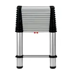
Everyone may get a good laugh out of what I am fixing to say:laughing7:, but this is experience talking. If you are in or around the Caballo's treasure hunting or prospecting, you will soon learn
that one of your best friends is going to be a 16ft aluminum extension ladder, you will need it for above and below uses, no matter how clever you are , nothing else will work, don't bother taking one
in with you, after you have been in there for awhile you will find were others have already stashed theres,:laughing7::dontknow: np:cat:

Been thinking about this for where the drone won't suffice. So many caves in sheer locations. Don't they make a collapsible escape-type ladder? Easier to hike with. Stash a few for me. October weather is just around the corner!
TEL1600E_1.jpg
 

Not to Scale, or Not Not to Scale? Maybe Both.

Jose,

You have it backasswards.

SDCFIA,

Here is my best on the island. I found this a while back when I first saw that map. Notice how on the map there is a pass just SouthEast of the island:

View attachment 1080573

The island is oriented exactly like on the map, and Palomas Pass and Apache Pass are in the exact right spots as well. This map shows The Rio Grand, Caballos, San Andres, and maybe Northern tip of Organs.

Mike

Maybe make a grid and see if they made it to scale at all. I used graph paper in my printer. Mike's assertion mostly matches with what I came up with.

It's seeming to me more and more that big shiny landmarks and names on modern maps look good from 1,000 miles away (some only have this to work with, so understandable), but it ends up feeling much more comfy settling in on more modest features on the ground, especially given signs there. Based on *pre-existing* native petroglyph concentrations (at least one amazing site is not very well known at all!) in the local area, I think that these may have been used as-is by the makers of the map, just like a piloncillo (not pelon-cillo that sounds like a big head or something?) or soledad or ojo de piedra. That there are also mineral deposits (some quite productive) and Spanish-era signs at several of these spots is also compelling. At least 3 of the glyph collections feature symbols 1:1 with the map. Maybe use the existing signs, as natives might defile a cross but leave their own stuff alone?

Also, I think that the bigger peak to the East (island at the top of the map in my interpretation) is Geronimo peak (right next to VP). Not sure if this is something others have already espoused.

Another fun exercise is to get all your Dobies and Kenworthys and Mahons and other signs and symbols references out and have a Sesame Street session. The symbols match, but is that a snake or a spring or a squiggly pointer? Dang it! Wish I was cool enough to have that insider Spanish archive stuff with the symbol codex in it. At least I saw the horseshoe vs. muleshoe used for troop accounting on some real 1700's docs in an exhibit once.

Oh yeah, and the N-S vs E-W scale seems very different for anything I could muster. Maybe Spanish 8 1/2 x 11 paper was in sixth-estados or something. Or, I just have the map upside down :) The sun symbols actually agree with that, even though all the other important geography and ground signs I have seen so far do not. Oh yeah, and all I came up with for the ankh is that it may be associated with Venus. I'm not a star-guy so I have no idea how to use that even if it is relevant. Maybe an astronophile could help? Can that disambiguate N-S/E-W for us?
 

I believe this is the vault that Cheatham was looking for with the GPR up near Longbottom canyon on his claims.
Apparently thought he found the rabbit ears.
Seems to me, this does not match Willies cave.
Willies cave was apparently easy enough to enter that the lourius and herberer couples could just walk in.
I dont think these older couples would climb down 60 feet in a crack?
And Reece Palmer as a hunch back cripple could also enter willies cave. I dont think he could climb down into a 60 foot deep crack in his condition.

So, I guess in my mind I have this vault (counting room) is not Willys cave and also different from the Doc/Carriaga cave.
When I find the maps from the dead Padre I will know for sure.:hello2:
wr

They (whoever) dug down through a bunch of decomposed granite only about 6-8' right at the base of the rabbit/burro "ears" north of longbottom. They were also drilling with a rig due south at one point across Longbottom after that. Maybe more has gone on. Have not revisted that particular place in a while.

Lots of digging in solid limestone or, at the other end of the spectrum, crumbly loose stuff in those mountains. Not sure why this makes sense, especially the limestone. I can see mucking out fill, but why bother blasting through limestone when there's got to be a way in (to wherever).

Some old letters I've been let read say Willie's cave is only 15 foot deep and a slight incline, but very well hidden. Matches well with one of the Tollman folklore collection project stories that's supported by long-gone (but documented!) markers.

I think the skull of a redhead was found not too far from those ears at one point way back. There's some murder thing I can't remember where the car was found up in ABQ.
 

ive never been to VP. But i taken the wife and kids to the caballos several times a year for the past 5 years. Sometimes i go alone. Ive mostly stayed on the west side, but the laat few trips we've been exploring the top and east side. Its just a neat place

If the kids like rockhounding, its an OK place on the East side up north. Lots of (ugly) p-wood, tons of fossilized oyster shells (look for dark earth with a slightly purple cast, or formation #2 is real yellow) to the East of the main N-S road that goes from the dam-Engle road and turns south just shy of Laguna del Muerto (private land - boo, or yay?) at the mailboxes and big alamo.

Supposedly sharks teeth and even reports of fossilized pearls (?) per NM Tech, but maybe on the Armendariz part of the grant (aka Turner-land). Also, dino bones in the McRae formation, and even though they've technically found T-rex parts there, they are supposedly not much to look at. Also, the "fakimer" diamonds (big double-terminated clear quartz) are on the East side.

Maybe a little less exciting of a place to camp, but worth some time researching in NM Tech Open File Reports online and a day trip. If you find the wire gold in the un-named pink granite formation, at least send me a picture. Leave all the signs as you find them, please, especially the subtle ones.

Oh yeah, geology in action: there's p-wood on the very top line of the mountain, and same stuff down in the flats as well. Rift valley formation! Wonder what angle that makes all the caves that are supposed to go through the mountain?
 

nmth, why NP's lil map. it is accurate as to period and locations. and shows a reasonable source for Dore' bars.

Hi Real, not sure what you are asking, exacly, but I'll say a few things (opinions, and *far, far* less earned than a lot of others here!)

When I was first shown that map by a friend (I did not see it here first), I thought it looked "hokey". This is before even reading it. It seemed too "clean" and there was not much geography to key in on (my preferred approach - I don't trust names). How many "Caballo" mountains, ranges, and peaks have there really been in the SW and Mex through the ages? !quien sabe! I've seen the Organs not be on maps, be only where the Franklins are now, be SOUTH of El Paso, be where they are now, and also extend clear up to Socorro through the San Andres. Don't get me started on Tres Hermanas vs. Tres Hermanos, either, por ejemplo.

Presently, I am more interested and willing to consider the "lil map" (snake map?), if I have the name right, as thematic clues for field work as much as anything else. Lacking great "connections", I rely on themes to make progress. Most of what little I have stumbled across has no story or name associated, or if it does, then the stories have been very wrong in the details (go figure).

I am suspicious of some aspects of the handwriting style and spellings, and without access to a visual inspection of the material, I'd not really be able to give any sort of an age to it. I'm not on the single-story, grand conspiracy side of the fence - so I have not pondered super-coded stuff (LUE, anyone?) or global-scale or lost history stuff too much in this context. I like the 7's of things, heart, 3's crosses, and other subtleties like the pulled S in the smaller "Sonora". Nonetheless, it looks most like a modern hand copy of some original. You can play all kinds of number games like getting 1716, etc. and there's 8 or 9 "+" on the left, depending on how you count. Why so much detail effort into the snake? Who was Padre Orosco? Is Orosco an older spelling than Orozco? Wish they had "Baca" or "Vaca" on there somehere. Less V's in the way back. Could the mesa be Black Mesa? Abandoned pueblo there by the river and really old looking goat corrals up top. I am sort of liking the idea that the heart part of the map is a "blow-up" of the almacen detail - but was this a cartographic technique way back when? We have hover text for everything now, but then? The sun figure is like a compass and did not Willie D. start in the black range chaining his way to the fabled stash cave? What's the point of the random-looking mountains/hash marks in the upper right? Given the triangles are directional arrows drawing goodies into the range, then it sort of makes me think it's Abo, Quarai (Gran Quivira) area. Scale of the map overall has to be quite off. What's the indian-looking name in the upper left? For the mines, do any of the relative distances between those mines translate to a number that let's us figure out how far each dot is apart?

So, what I get from the lil map without too much deep thought does not help me in particular overmuch as I have no personal story to go with it that I can verify, and I'm already out there stomping around with a fat back pocket of hard-earned local data; and crosses, hearts, threes, sevens, etc. and so on are always part of my "filter". Not being as great a researcher as others here, where it came from and when matters less to me, up until something might be found, since ultimately sign on the ground has to be located that is compelling, as I'll not end up being some blind excavator type - which may make me ultimately unsuccessful. Unless I get more detailed "key" information (how do I *know* snake symbols mean this or that?) the sign has to be "reasonable", and I expect that it would be considering it was expected to be durable and unambiguous, even in the midst of a dehydration-inducing wasteland filled with hostiles 1,000 of miles across an ocean from "true" civilization. So, as a poor cog in the machine with a 9-5, I'd need a huge grubstake to be able to do more than add these themes to my occassional forays into nature (which I enjoy very much in their own right) as I keep my Eye open for solid opportunities of all sorts.

Any way it's sliced, though, I am *very* grateful for the sharing of the map and associated explanations/theories/history! After the $ are spent, it's the history (truth) that's of indelible value in particualr (so pass your secrets down somehow, o knowers of the otherwise unknown.)
 

Hola my friend. IAn excellent post.'ll try to clear up a few of your points.

First, and most importantly that is not supposed to be a treasure map, but a route map.

The so called snakey thing is a put in there to connote a religious thingie. It is a religious symbol used by high ranking officials,.

The markings at the left are to in reference to various mines and things of importance., including old trails.

Orozco was a priest at Tayopa

The small house with the date apparently was added later, and is in essence correct.

There is a lot more that i could add, but this will suffce for this post. Ask away my friend, that is the only we can establish it's place ib history..
 

Last edited:

Top Member Reactions

Users who are viewing this thread

Latest Discussions

Back
Top