Artemis Site-You Go Girl

Allegedly, a letter written in Spanish was found in the ruins of an old adobe house in Santa Clara NM. I neither know when the letter was written or by whom, nor who found it or when. I may be wrong about the town as it's been quite a few years since I heard the story, but Santa Clara seems to be the home of many secrets.

I haven't seen the entire contents of the letter, but a few lines from it were included in a private booklet entitled Secrets of La Sierra de Cuco, written by my surveying buddy Johnny Sosaya ~2001/2002 that discussed several intriguing Cookes Range petroglyphs.

"Al rumbo al norte, pasado Las Tres Hermanas, encontraras La Sierra de Cuco que come de la mesa. Aye tanto oro que se qui de la mesa."

Translated as, "To the north, beyond the Three Sisters Mountains, you will encounter a mountain range where a bogeyman eats off the land. There you will find so much gold that it spills over the land."

Tres Hermanas. Tres Hermanos. Lots to learn looking into the drift of those names over time. But what anchors this to the presently assumed range by Columbus?

The Mexican Boogeyman I know of is El Cucuy.
 

Tres Hermanas. Tres Hermanos. Lots to learn looking into the drift of those names over time. But what anchors this to the presently assumed range by Columbus?

The Mexican Boogeyman I know of is El Cucuy.

Tres Hermanas is a place I've never explored, but always wanted to. It's a landmark that one crazy told me was a visual replication of the pyramid triad at Giza, Egypt, and was sought by ancients during their explorations in the region at some point way back in time. I don't know about that, but the three hills do present an unmistakable sight. The photo of the hills below was taken from the site where the carvings in posts #179 and 183 are located, about 37 miles away from Tres Hermanas. By the way, most folks call that petroglyph site Frying Pan Canyon. Others refer to it as Mine 7. The Cuco carving is at a place called Mine 6.

Tres Hermanas.JPG

Another story persists that a tunnel or cavern system links Tres Hermanas with the Florida Mountains in Deming NM, about 15 miles away. They say the Apaches used it to escape the bluecoats now and then back in the day. That cavern system allegedly also extends to the Twin Sisters vicinity (source of giant treasure rumors), just north of Silver City. Three Sisters to Twin Sisters - about 70 miles. Here's a curiosity. If you make an equilateral triangle with Twin Sisters and Three Sisters as two of the corners, the third corner is almost exactly at Point of Rocks in the Caballos - another important landmark.
 

Last edited:
Tres Hermanas is a place I've never explored, but always wanted to. It's a landmark that one crazy told me was a visual replication of the pyramid triad at Giza, Egypt, and was sought by ancients during their explorations in the region at some point way back in time. I don't know about that, but the three hills do present an unmistakable sight. The photo of the hills below was taken from the site where the carvings in posts #179 and 183 are located, about 37 miles away from Tres Hermanas. By the way, most folks call that petroglyph site Frying Pan Canyon. Others refer to it as Mine 7. The Cuco carving is at a place called Mine 6.

View attachment 1501172

Another story persists that a tunnel or cavern system links Tres Hermanas with the Florida Mountains in Deming NM, about 15 miles away. They say the Apaches used it to escape the bluecoats now and then back in the day. That cavern system allegedly also extends to the Twin Sisters vicinity (source of giant treasure rumors), just north of Silver City. Three Sisters to Twin Sisters - about 70 miles. Here's a curiosity. If you make an equilateral triangle with Twin Sisters and Three Sisters as two of the corners, the third corner is almost exactly at Point of Rocks in the Caballos - another important landmark.

I always thought of the 3 sisters as Orion's belt. I have found the photos you have posted of twin peaks very interesting also, I do feel a draw to them,like a very important place. Thanks for that info.and photos SDC.
 

Tres Hermanas is a place I've never explored, but always wanted to. It's a landmark that one crazy told me was a visual replication of the pyramid triad at Giza, Egypt, and was sought by ancients during their explorations in the region at some point way back in time. I don't know about that, but the three hills do present an unmistakable sight. The photo of the hills below was taken from the site where the carvings in posts #179 and 183 are located, about 37 miles away from Tres Hermanas. By the way, most folks call that petroglyph site Frying Pan Canyon. Others refer to it as Mine 7. The Cuco carving is at a place called Mine 6.

View attachment 1501172

Another story persists that a tunnel or cavern system links Tres Hermanas with the Florida Mountains in Deming NM, about 15 miles away. They say the Apaches used it to escape the bluecoats now and then back in the day. That cavern system allegedly also extends to the Twin Sisters vicinity (source of giant treasure rumors), just north of Silver City. Three Sisters to Twin Sisters - about 70 miles. Here's a curiosity. If you make an equilateral triangle with Twin Sisters and Three Sisters as two of the corners, the third corner is almost exactly at Point of Rocks in the Caballos - another important landmark.

Sdcfia, you are making my heart yearn for home, especially with the picture.

There is so much history yet to be discovered in S. NM!

I have plied the areas around the aforementioned neglected regions, with a special eye that the Nature Fascists and meat killers and even the rockhounds and stone-hunters don't have. Very cool stuff abounds.

Forget the name on the map you see today. What was the name so long ago? Why would it make sense to even have been mentioned? Forget today's name...

The tunnel stories. What to say? Wish they were real. It would be neat! Cenotes from Carlsbad to the Yucatan, I believe. But they are useless as all underwater.

Good effort by all around here. Glad we are able to contribute without self-defeating conflict and strife. We don't have to agree. We will progress in our individual knowledge with the reasoned input of others.

Dog: nice video. You are obviously spending real time and treasure in your quest. Your time is the real treasure. Spend it VERY wisely. Well, you may be young: spend it carefully, anyways. When you get to be wise, it may be too late! Life is short.

It's finally October in NM! Green chile cheeseburger to whoever calls me out first in person out on the last scraps of free land we can still enjoy.

Excelsior!
 

I always thought of the 3 sisters as Orion's belt. I have found the photos you have posted of twin peaks very interesting also, I do feel a draw to them,like a very important place. Thanks for that info.and photos SDC.

Wow, dog tth, I guess you nailed it. I overlaid Orion's Belt stars on the three peaks and was surprised at the results. Pretty close match, eh? As usual, strangeness abounds in the Land of Enchantment.

tres hermanas.jpg
 

Sdcfia, you are making my heart yearn for home, especially with the picture.

There is so much history yet to be discovered in S. NM!

I have plied the areas around the aforementioned neglected regions, with a special eye that the Nature Fascists and meat killers and even the rockhounds and stone-hunters don't have. Very cool stuff abounds.

Forget the name on the map you see today. What was the name so long ago? Why would it make sense to even have been mentioned? Forget today's name...

The tunnel stories. What to say? Wish they were real. It would be neat! Cenotes from Carlsbad to the Yucatan, I believe. But they are useless as all underwater.

Good effort by all around here. Glad we are able to contribute without self-defeating conflict and strife. We don't have to agree. We will progress in our individual knowledge with the reasoned input of others.

Dog: nice video. You are obviously spending real time and treasure in your quest. Your time is the real treasure. Spend it VERY wisely. Well, you may be young: spend it carefully, anyways. When you get to be wise, it may be too late! Life is short.

It's finally October in NM! Green chile cheeseburger to whoever calls me out first in person out on the last scraps of free land we can still enjoy.

Excelsior!

Very cool stuff indeed - even you might be surprised. I tried to leave three or four times for greener pastures, but nowhere else satisfies. I guess we're fortunate when we find the place that's right.

Place names are very important. Many of the ones we use now have changed even in the past hundred or so years. Heck, even the village of Santa Clara that I mentioned in post #200 was named Central until twenty years ago. Ancient place names? Good luck.

Tunnels? The best rumors are too crazy to even mention. You'd probably sooner believe the story of the Thunderbird my pal and I saw in the Cookes Range. Ha ha.
 

Wow, dog tth, I guess you nailed it. I overlaid Orion's Belt stars on the three peaks and was surprised at the results. Pretty close match, eh? As usual, strangeness abounds in the Land of Enchantment.

View attachment 1501257


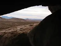
Nice work SDC, thanks. Even that photo you posted of the 3 sisters from the overhang,cave, is a very nice and precise alignment with that hill top pointing to a very important place in that range. I was shocked when i seen it. To me its not a lucky shot at all. There is a connection for sure.At least i think there is. Are those round holes in that bedrock,stone where you took that photo from? Oh there is also a dried up spring at that location in the 3 sisters. But i dont think that alignment is about that. Thanks again,thats important info. and photos to me.
 

Nice work SDC, thanks. Even that photo you posted of the 3 sisters from the overhang,cave, is a very nice and precise alignment with that hill top pointing to a very important place in that range. I was shocked when i seen it. To me its not a lucky shot at all. There is a connection for sure.At least i think there is. Are those round holes in that bedrock,stone where you took that photo from? Oh there is also a dried up spring at that location in the 3 sisters. But i dont think that alignment is about that. Thanks again,thats important info. and photos to me.

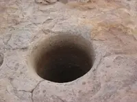
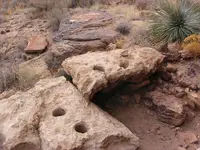
Yes, those are what have been identified as bedrock mortars, presumably used to grind corn, mesquite pods, grains, etc. It seems to me that these things are always found in uncomfortable working locations on solid rock with no shade nearby. Me? I'd rather use a metate and mano in a comfortable shaded location. Below are some more found at Mine 7.

Hole 6.JPG Hole 4.JPG
 

Thanks for the link, dog. There is so much good stuff in the upper midwest and the entire Mississippi Valley that it makes your head spin. The artifacts, intaglios, and mostly disappeared structures and trails are not only intriguing, but quite mysterious when you apply the axis mundi directional links ala guys such as Cort Lindahl and others. How's your Tylenol supply?

SDC, you've posted a link about a possible migration from the Mississippi to Mexico City by Mound Builders from Cahokia. Have you, or any other of you Tnet posters, ever heard of a possible migration of the Aztecs back to the upper Mississippi River valley? I've posted a link, in the past, about a migration of the Winnebago tribe from the southwest to the upper Mississippi River valley. Here's the link.

The Spanish Fight

Carver said the migration took place a century before his account which would have been about 1667. I've always wondered, why they would head to the Wisconsin region unless they were familiar with that place. I've been trying to find a link, so I looked for any evidence of migration from Wisconsin toward the southwest and then back again. I looked for any cultures that might have constructed platform mounds in the southwest and found the Hohokam in Arizona. Here's a series of events that might, or might not, be related.

Aztlan Mississippian settlement in southern Wisconsin was settled about 900 AD and abandoned about 1200-1300 AD.
Cahokia mound building efforts began about 800 AD and Cahokia was abandoned about 1300 AD.
The Hohokam of Arizona, were building platform mounds between 1250 and 1350 AD.
In 1376 AD, the Aztec royal dynasty was founded.
In 1478-1479 an Aztec army was defeated by their Tarascan neighbors.
In 1517, Montezuma was informed of the arrival of Spanish ships.

Now here is something that's kind of interesting. The site of Etzanoa was confirmed at Arkansas City, Kansas.

Etzanoa: The Great Settlement - (2016) Spring 2016 - THE SHOCKER

It's estimated that the site was occupied between 1500 and 1720. It seems the primary occupation at the site was hunting Buffalo for the meat and hides and then transporting that product to other areas. If a large group of people were moving from Mexico, or our southwest, it would be helpful to have food stocked at various places along the trail.

The Winnebagos arrived in the upper Mississippi River valley about 1667. I wonder if the Winnebagoes were fleeing the Spanish and passed by Etzanoa or maybe they were living at Etzanoa and fled toward Wisconsin. At any rate, it will be interesting to see what the archeological digs turn up at Etzanoa, over the years.
 

SDC, you've posted a link about a possible migration from the Mississippi to Mexico City by Mound Builders from Cahokia. Have you, or any other of you Tnet posters, ever heard of a possible migration of the Aztecs back to the upper Mississippi River valley? I've posted a link, in the past, about a migration of the Winnebago tribe from the southwest to the upper Mississippi River valley. Here's the link.

The Spanish Fight

Carver said the migration took place a century before his account which would have been about 1667. I've always wondered, why they would head to the Wisconsin region unless they were familiar with that place. ...

I remember reading that story the first time you posted it, dog. Presumably the Black Robes encountered by the Winnebago supports your research into the French Jesuits' activities in CO. The Winnebagos' migration theory is another example of our missing history.

I don't know of any stories that the Aztec migrated back to North America, although there's plenty of evidence that they traded with groups in many Southwestern locations - tropical feathers, sea shells, etc, found in ruins, Mexican style petroglyphs, and so on.
 

Yes, those are what have been identified as bedrock mortars, presumably used to grind corn, mesquite pods, grains, etc. It seems to me that these things are always found in uncomfortable working locations on solid rock with no shade nearby. Me? I'd rather use a metate and mano in a comfortable shaded location. Below are some more found at Mine 7.

View attachment 1501328 View attachment 1501329

Id have to agree with you. It would be much better to sit in the shade.
 

Yes, those are what have been identified as bedrock mortars, presumably used to grind corn, mesquite pods, grains, etc. It seems to me that these things are always found in uncomfortable working locations on solid rock with no shade nearby. Me? I'd rather use a metate and mano in a comfortable shaded location. Below are some more found at Mine 7.

View attachment 1501328 View attachment 1501329

I had thought before, that maybe they represent constellations or certain stars. Then again maybe for wooden poles for a ailment or shadow pattern that forms as the sun moves.
 

I've seen carvings like your tadpole-looking guy before, too. If I can find some, I'll post. I think there might be one at Pony Hills, just west of the Post #183 site and every bit as intriguing, if not more in some ways. That entire Cookes Range is awesome. Have you seen this goggle-eye fellow? He's known as Cuco the bogeyman.

View attachment 1499958


Yes, I spent many, many hours applying the phi ratio to spatial relationships of things found on the ground. I was fortunate because at the time I was still working with land modeling and surveying AutoCAD software for a paycheck out of my home office. After hours, I was able to very accurately plot all my discoveries on various layers with topo and township grid backgrounds, then overlay the whole shebang with squared circles, nautilus spirals, KGC templates, Solomon temple footprints, et al and scale them up and down at will to see what the relationships might be. There were some interesting coincidences, but a million down-the rabbit-hole possibilities. At a certain point, I abandoned the strategy.

I had much more interesting results with basic geometrical shapes and straight lines, especially applying certain repeating azimuth alignments. Also, I've played some intuitive hunches (mine and others') that have led me to important finds. Sometimes we tend to overthink this stuff and get confused.

I think owl symbology is intriguing, but I've never found an obvious (to me anyway) example in the field. Not one.

Then look at Cuco. A dot for one eye, dash for the other. One hand well defined filled in, the other deformed hollow. Does Cuco represent energy, proton,neutron with a nucleus?
 

Last edited:
Allegedly, a letter written in Spanish was found in the ruins of an old adobe house in Santa Clara NM. I neither know when the letter was written or by whom, nor who found it or when. I may be wrong about the town as it's been quite a few years since I heard the story, but Santa Clara seems to be the home of many secrets.

I haven't seen the entire contents of the letter, but a few lines from it were included in a private booklet entitled Secrets of La Sierra de Cuco, written by my surveying buddy Johnny Sosaya ~2001/2002 that discussed several intriguing Cookes Range petroglyphs.

"Al rumbo al norte, pasado Las Tres Hermanas, encontraras La Sierra de Cuco que come de la mesa. Aye tanto oro que se qui de la mesa."

Translated as, "To the north, beyond the Three Sisters Mountains, you will encounter a mountain range where a bogeyman eats off the land. There you will find so much gold that it spills over the land."

Thanks, SDC. Do you have any thoughts about what "...where a bogeyman eats off the land." might mean? Maybe miners mining in the mountain range?
 

Thanks, SDC. Do you have any thoughts about what "...where a bogeyman eats off the land." might mean? Maybe miners mining in the mountain range?

My friend Johnny - who, by the way, has some astounding insights into petroglyphs, what they mean, and more importantly, how their placements were chosen - only surmised that the phrase was meant to describe a dark and negative presence. When you couple this idea with the other line in the letter, "... so much gold that it spills over the land," and the history, legends and traditions in the region, it's logical to assume the writer was referring to mining. Some of those legends describe some bad exploitation of locals by outsiders. After all, Cuco is found at Mine 6, midway between Mines 5 and 7 - all extremely interesting sites that seem to have evidence of filled-in workings from long ago.

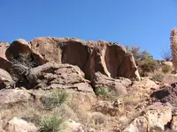
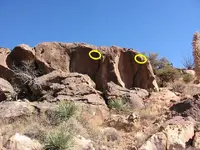
For those who can see shapes in rocks, the Cuco carving site itself appears quite menacing - even uncomfortable to some. The formation appears to resemble a skull or a creature with two angry deep eye sockets separated by a long beak-looking thing. Yeah, a bogeyman.

Cuco 2.JPG
 

My friend Johnny - who, by the way, has some astounding insights into petroglyphs, what they mean, and more importantly, how their placements were chosen - only surmised that the phrase was meant to describe a dark and negative presence. When you couple this idea with the other line in the letter, "... so much gold that it spills over the land," and the history, legends and traditions in the region, it's logical to assume the writer was referring to mining. Some of those legends describe some bad exploitation of locals by outsiders. After all, Cuco is found at Mine 6, midway between Mines 5 and 7 - all extremely interesting sites that seem to have evidence of filled-in workings from long ago.

For those who can see shapes in rocks, the Cuco carving site itself appears quite menacing - even uncomfortable to some. The formation appears to resemble a skull or a creature with two angry deep eye sockets separated by a long beak-looking thing. Yeah, a bogeyman.

View attachment 1501830

Thanks SDC. That rock formation does look like the eyes on the Cuco carving. I' be been trying to figure out the squares that make up the body. If the body was made up of circles, instead of rectangles, I would guess that it represented a hill. I wonder if the body might be showing a pyramid. Are the eyes, on the rock formation, from natural erosion?
 

My friend Johnny - who, by the way, has some astounding insights into petroglyphs, what they mean, and more importantly, how their placements were chosen - only surmised that the phrase was meant to describe a dark and negative presence. When you couple this idea with the other line in the letter, "... so much gold that it spills over the land," and the history, legends and traditions in the region, it's logical to assume the writer was referring to mining. Some of those legends describe some bad exploitation of locals by outsiders. After all, Cuco is found at Mine 6, midway between Mines 5 and 7 - all extremely interesting sites that seem to have evidence of filled-in workings from long ago.

For those who can see shapes in rocks, the Cuco carving site itself appears quite menacing - even uncomfortable to some. The formation appears to resemble a skull or a creature with two angry deep eye sockets separated by a long beak-looking thing. Yeah, a bogeyman.

View attachment 1501830

If it isn't too much trouble, what did your friend come up with about the petroglyphs? If you can say.
 

Thanks SDC. That rock formation does look like the eyes on the Cuco carving. I' be been trying to figure out the squares that make up the body. If the body was made up of circles, instead of rectangles, I would guess that it represented a hill. I wonder if the body might be showing a pyramid. Are the eyes, on the rock formation, from natural erosion?

Yes, the eyes are natural depressions in the rock face. I was told that the yellow circles are areas where the rocks were worked long ago to show the "pupils" and "irises" of the eyes. I didn't notice this when I took the photo, and I haven't been back since then to check it out. It's been on my list of things to do for years now. That list seems to keep growing.

bogeyman.JPG
 

If it isn't too much trouble, what did your friend come up with about the petroglyphs? If you can say.

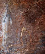
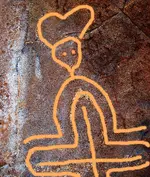
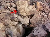
No problem, mdog. The carving done on the petroglyph figure's left hand was much more carefully done than his right hand. Allegedly, the left hand points to two concealed openings, less than a hundred feet away, to a mine located inside a cavern system. One of the openings is just below the right eye of the big rock formation, and the other is just above it, on top. A faint "mark of possession" is etched on the surface just to the left of the long nose, or beak. I don't know about the lower entrance, but somebody has tried to remove the backfill from the top entrance - a very tough task with ropes and buckets. It was marked by a large heart-shaped flat rock. Whomever did the work quit after about 20 feet - I don't know if they came back later to keep trying, as it's been years ago since I was there. This site is called Mine 6.
heartcross1.jpg heartcross2.jpg

Heart 2.JPG

Back to the petroglyph figure. It is claimed by some "amateur experts" that the pattern of concentric rectangles mark certain calendar dates (equinoxes, solstices, etc) with sun shadows. I haven't seen any proof of this. It's also claimed by "treasure guys" that the carving's eyes, hands, etc. can be used with certain shadows to point at stuff. I haven't seen any proof of this either.
 

No problem, mdog. The carving done on the petroglyph figure's left hand was much more carefully done than his right hand. Allegedly, the left hand points to two concealed openings, less than a hundred feet away, to a mine located inside a cavern system. One of the openings is just below the right eye of the big rock formation, and the other is just above it, on top. A faint "mark of possession" is etched on the surface just to the left of the long nose, or beak. I don't know about the lower entrance, but somebody has tried to remove the backfill from the top entrance - a very tough task with ropes and buckets. It was marked by a large heart-shaped flat rock. Whomever did the work quit after about 20 feet - I don't know if they came back later to keep trying, as it's been years ago since I was there. This site is called Mine 6.
View attachment 1502209 View attachment 1502210

View attachment 1502213

Back to the petroglyph figure. It is claimed by some "amateur experts" that the pattern of concentric rectangles mark certain calendar dates (equinoxes, solstices, etc) with sun shadows. I haven't seen any proof of this. It's also claimed by "treasure guys" that the carving's eyes, hands, etc. can be used with certain shadows to point at stuff. I haven't seen any proof of this either.

This is an interesting story. Thanks SDC. Just to make sure I have it straight. A natural rock formation was modified to show the pupils and irises of two eyes. A petroglyph was carved on this formation, maybe to show there was information to look for. Then the ownership petroglyph was used to show the closed entrance on top with the heart rock by it. Is the outlined cross the ownership mark. You've written about that mark before and, from what I remember, it has been used for a long time. Seeing as how the natural formation was already there, there must have been something of value hidden away in the cavern to go to the trouble of creating the petroglyphs. Also, unless it was a crazy coincidence that there were mines by the formation, something must have been transported along the trail. Maybe a temporary hiding place. Any idea about the owners? Thanks again.
 

Last edited:

Top Member Reactions

Users who are viewing this thread

Back
Top