ANCIENT VOICES: Ditlihi's Journey Into The Truth Of Ancient Treasure In The Southwest

Status
Not open for further replies.
Ok’ Kentuck, I kinda think that the image in that post, looks much like a world map. Crude, but somewhat accurate.
“In my humble opinion”

#/;0{>~


Quite possible, my friend. Would be interesting to see the entire panel, wouldn't it.

In reviewing this thread from the beginning, it's obvious there were a lot of details left unsaid, unmentioned, in those photos. Understandably, of course; no one wants to lay down all their cards in this 'vocation' of ours.

But I believe the thread was cut short for a completely different reason. I get the distinct feeling that the author was attempting to draw a picture for us through her live experiences, to both share those experiences with us and draw from the communal knowledge base found here among friends and associates....in an effort to involve us All in the solution to this puzzle. A first, I believe. A gift.

Seldom have I seen a treasure hunter share so much with so many, without greed, without paranoia, without control issues or a Guru Complex. Just for the sake of drawing us all together to solve a great mystery.

It's a crying shame that our access to that mystery was cut short. And the reason was easy to deduce after reviewing the thread once again. Humility faced with Hubris does not mix well. Never will. Not even with a Humor Chaser. :-\
So here's to Humility, my friend, may we never lose sight of it in our journeys. :occasion14:

Looking forward to seeing you soon when this current Crisis is over. Be safe and be well. :notworthy:
 

How did they do it? Pretty simple actually. :wink:

Goes downhill for me at about 2:50. Yeah, works OK for laying out a site plan as long as you already have an accurate calendar. Where did the ancients get one?
 

I keep hearing all these references to a "King's Trail" when perusing the Treasure Marks & Signs forum. :icon_scratch:

The Real 'King's Trail' is much older than some would like to believe, and predates the Spanish by thousands of years.

" The Royal Road of the King of the World is a 20-degree band around the Earth that has 30 degrees north latitude as its center. This band is not, technically, the geographical center of the Earth, which is marked by the equator. But when the square miles of land south of 30 degrees’ north latitude are counted together (not including the Arctic or Antarctica), and the square miles of land north of 30 degrees north latitude are similarly tabulated, both equal approximately 26 million square miles. Thus, the Royal Road of the King of the World exists at the very center of Earth’s landmass. In ancient times this central region was denominated by many civilizations living upon it as the “Center of the Earth.” "


The Royal Road of the King of the World, and the Ancient Center of the Earth


:coffee2: :icon_study:

As I recall, the Great Pyramid at Giza has been alleged to be the center of all landmass on earth, not just north/south at 29Âş58'34" N latitude, but also east/west at 31Âş7'58" E longitude. An interesting bullseye. This point on the globe has been recalculated many times in recent years using WGS84 datum, satellite land imagery, computer models, etc. and has shifted quite a bit with several different results.

Of course, we don't know what the planet's landmass was when the pyramid was built - many alleging way before the last Ice Age when a massive cataclysm changed the planet. However, the point is that it's at 30ÂşN today and the structure has been venerated by humans as long as far back as our current history goes. Still quite an important benchmark and maybe the basis for the Kings theory.
 

Goes downhill for me at about 2:50. Yeah, works OK for laying out a site plan as long as you already have an accurate calendar. Where did the ancients get one?


Sometimes the simplest concepts are the hardest to grasp.

What is a calendar, Steve?

Does it require a calendar...to make a calendar?

What if your site plan IS a calendar itself?

A calendar is merely a record of regularly recurring events, in this case the position of the sun on a particular day....a Solar Calendar. One need look no further than the abundance of ancient solar sites across the globe to find an accurate solar calendar. How they were created has long been known and is nothing new. Observation and recording. Simple enough. And through this video we see that the same principles were used in making a site plan.

What the video in question revealed to me, was the possibility the authors site was an ancient solar calendar site, and the fact that some ancient civilizations have encoded those key calendar dates into their everyday accoutrements, pottery, textiles, etc. In other words, while she found no artifacts...she may have had the answer to the questions of "Who, How & Why" by looking to the historical inhabitant's (Mimbres, Mogollon, or even Aztecs) artwork and the designs encoded in it. The panel I mentioned being a possibility.

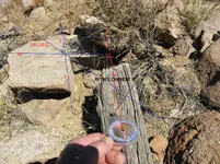
She already had the tools to find true North (A staff) from the "John/Mark Monument", and the point of solstice sunrise at the "Gunsight". Simple enough to figure any relevant angles and degrees from there.

Nothing more. Nothing complex to project. Just a Simple method for finding a possible explanation to the mystery.

Of course, if one wanted to "project complexity", I suppose it could also be the creation of some clever esoteric secret organization using the same methods to mark huge treasure depositories. A Calendar map you could say.

Geographical Landscape as a Geometrical Landscape, Geological Landscapes as Astronomical Landscapes, and the Combination of the Two.


:icon_scratch: :dontknow:
 

Last edited:
Sometimes the simplest concepts are the hardest to grasp.

What is a calendar, Steve?

Does it require a calendar...to make a calendar?

What if your site plan IS a calendar itself?

A calendar is merely a record of regularly recurring events, in this case the position of the sun on a particular day....a Solar Calendar. One need look no further than the abundance of ancient solar sites across the globe to find an accurate solar calendar. How they were created has long been known and is nothing new. Observation and recording. Simple enough. And through this video we see that the same principles were used in making a site plan.

What the video in question revealed to me, was the possibility the authors site was an ancient solar calendar site, and the fact that some ancient civilizations have encoded those key calendar dates into their everyday accoutrements, pottery, textiles, etc. In other words, while she found no artifacts...she may have had the answer to the questions of "Who, How & Why" by looking to the historical inhabitant's (Mimbres, Mogollon, or even Aztecs) artwork and the designs encoded in it. The panel I mentioned being a possibility.

She already had the tools to find true North (A staff) from the "John/Mark Monument", and the point of solstice sunrise at the "Gunsight". Simple enough to figure any relevant angles and degrees from there.

Nothing more. Nothing complex to project. Just a Simple method for finding a possible explanation to the mystery.

Of course, if one wanted to "project complexity", I suppose it could also be the creation of some clever esoteric secret organization using the same methods to mark huge treasure depositories. A Calendar map you could say.

Geographical Landscape as a Geometrical Landscape, Geological Landscapes as Astronomical Landscapes, and the Combination of the Two.


:icon_scratch: :dontknow:

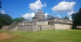
Yeah, anyone can put a stick in the ground and create a yearly sun record. I'm more interested in the guys who made observations for longer term cycles. Handy for navigation and other purposes.
el caracol.jpg

Well, Ol' K, since you've obviously gleaned insight from D's thread, maybe you can save my tired eyes from reading the 800 posts again and do my thick head a favor by offering a straight-ahead summarization of what the heck you think the girl was doing down in that desert. Then maybe this thread can be rebooted with a fresh approach.

~ What exactly is the mystery that intrigued her and launched the project?
~ Other than the sort-of Chacmool-looking rock photo, I didn't see any interesting evidence suggesting altered landscapes in the region. Of course I wasn't onsite to see for myself, but I've got a strong right-brain aspect and I just saw photos of various rocks.
~ I too greatly admire the Mimbres culture - what's known of it other than recovered artifacts and structure ruins. The artwork is terrific, the ruins are primitive. Do you think she has some theory about their presence and disappearance in the region?
 

Yeah, anyone can put a stick in the ground and create a yearly sun record. I'm more interested in the guys who made observations for longer term cycles. Handy for navigation and other purposes.
View attachment 1832647

Well, Ol' K, since you've obviously gleaned insight from D's thread, maybe you can save my tired eyes from reading the 800 posts again and do my thick head a favor by offering a straight-ahead summarization of what the heck you think the girl was doing down in that desert. Then maybe this thread can be rebooted with a fresh approach.

~ What exactly is the mystery that intrigued her and launched the project?
~ Other than the sort-of Chacmool-looking rock photo, I didn't see any interesting evidence suggesting altered landscapes in the region. Of course I wasn't onsite to see for myself, but I've got a strong right-brain aspect and I just saw photos of various rocks.
~ I too greatly admire the Mimbres culture - what's known of it other than recovered artifacts and structure ruins. The artwork is terrific, the ruins are primitive. Do you think she has some theory about their presence and disappearance in the region?


Nah, as much as it pains me I think she had the right idea by nipping it in the bud. I reckon you'll have to find a different wall to bounce your "thick head" off of. A simple concept that some find hard to grasp. :wink:

Have a good'un.
 

... as to your quote regarding "Karma", it's not Karma in its true sense if the individuals suffering the consequences of those past actions are not the perpetrators themselves, but merely those governed by them. In effect, Same as it ever was.


The only solution is Dissolution. Though I doubt we will see it in our lifetime. :-\


And that's all I got to say about that. :-X


" The words of the Prophet are written on the subway walls "

- Paul Simon

:notworthy:
 

Bump. Knock,Knock anyone home?


I'm still out here, Dog, glad to see you are surviving and still on the trail. Hope all is good and everyone is staying safe out your way. I'm keeping my social distance on the road, but I've always got time to listen.

Carry on my friend.
 

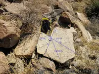
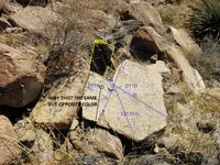
Whats up with this? Same symbol, but opposing colors. Maybe that littel white flake just happen to get blown in there?111013a 097.JPG
 

I reckon I'd have to ask what exactly you are referring to, first off. Are you suggesting the marks on the stone and the stone itself are a disguised map like Poussin's paintings are alleged to be? Or are you saying the stone is a marked waypoint from an existing Poussin Painting hidden map?

If the former, I'd have to ask what led you to the stone in the first place, were you following a marked trail or did you just stumble across it? And what leads you to believe someone would have left a stone map in that particular spot for someone else to find?

If a Waypoint, did you find the stone by following one of Poussin's alleged hidden maps?

I'm not versed in Poussin Paintings theory, so I really can't offer a valid opinion as to your map question in that respect. But I am familiar with mapping in general, and in that vein I would suggest....a Map generally leads from one point to another. Has this stone led you somewhere?

As to Poussin's paintings, I recently read a post on the forum regarding that subject by a fella with the handle Sluggo. You might hit him up, he seems to be a guru on the matter. Has made some interesting connections across the pond with them.
 

Last edited:
I reckon I'd have to ask what exactly you are referring to, first off. Are you suggesting the marks on the stone and the stone itself are a disguised map like Poissin's paintings are alleged to be? Or are you saying the stone is a marked waypoint from an existing Poissin Painting hidden map?

If the former, I'd have to ask what led you to the stone in the first place, were you following a marked trail or did you just stumble across it? And what leads you to believe someone would have left a stone map in that particular spot for someone else to find?

If a Waypoint, did you find the stone by following one of Poissin's alleged hidden maps?

I'm not versed in Poissin Paintings theory, so I really can't offer a valid opinion as to your map question in that respect. But I am familiar with mapping in general, and in that vein I would suggest....a Map generally leads from one point to another. Has this stone led you somewhere?

As to Poissin's paintings, I recently read a post on the forum regarding that subject by a fella with the handle Sluggo. You might hit him up, he seems to be a guru on the matter. Has made some interesting connections across the pond with them.

We will never know those questions what a train wreck for this thread.
 

Last edited:
I reckon I'd have to ask what exactly you are referring to, first off. Are you suggesting the marks on the stone and the stone itself are a disguised map like Poussin's paintings are alleged to be? Or are you saying the stone is a marked waypoint from an existing Poussin Painting hidden map?

If the former, I'd have to ask what led you to the stone in the first place, were you following a marked trail or did you just stumble across it? And what leads you to believe someone would have left a stone map in that particular spot for someone else to find?

If a Waypoint, did you find the stone by following one of Poussin's alleged hidden maps?

I'm not versed in Poussin Paintings theory, so I really can't offer a valid opinion as to your map question in that respect. But I am familiar with mapping in general, and in that vein I would suggest....a Map generally leads from one point to another. Has this stone led you somewhere?

As to Poussin's paintings, I recently read a post on the forum regarding that subject by a fella with the handle Sluggo. You might hit him up, he seems to be a guru on the matter. Has made some interesting connections across the pond with them.

Q1. Iam asking does anyone know if this is a map?
Q2. I just stumbled on to it. Or maybe i was guided to it by a force unknown to me.
Q3. It seems like a message left for someone .
Q4. I see symbols that i have seen in Poussin paintings.

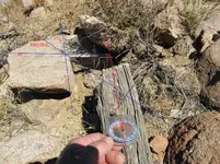
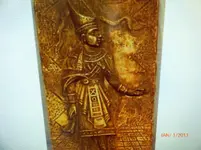
Question for you OK. Could you tell me who this person is or culture its from? Maybe what era its from. Reason, i see the same symbolic symbols .P1000681.jpg
 

Status
Not open for further replies.

Top Member Reactions

Users who are viewing this thread

Back
Top