ANCIENT VOICES: Ditlihi's Journey Into The Truth Of Ancient Treasure In The Southwest

Status
Not open for further replies.
This is a interesting viedo. I never knew of anything on the 33. Interesting what the guy has to say in the first comment below the video. Digging tunnels ? Dang sdcifa maybe i better pay more attention to what your saying.

"Within the 33rd parallel" is a pretty wide swath - up to 68 miles from 33º north latitude. I would only allow, say about a 5-mile offset, to make a site "interesting", as far as its placement is concerned .
 

I found this map overlay interesting. I went in a opening once that had a large stone on the floor that had this shape and color. The didn't seem to match the stones of the area.:dontknow:
 

"Within the 33rd parallel" is a pretty wide swath - up to 68 miles from 33º north latitude. I would only allow, say about a 5-mile offset, to make a site "interesting", as far as its placement is concerned .

I agree with you, SDC. Five miles is real good for the old lines. For the newer stuff, late 19th and early 20th centuries, a mile or less is good.
 

Sepehr at 7:30 if you have a intrest .

While the quest for eternal life is ancient and diverse, in the original Taoist alchemical context it is quite specific. In Chinese philosophy, the Tao is the absolute principle underlying the universe, combining within itself the principles of yin and yang and signifying the Way, or code of behavior, that is in harmony with the natural order.
 

Sepehr at 11:00 am if you have a intrest. This should be a great one to watch .

The Imperial and Royal Dragon Court was based upon an ancient bloodline tradition stemming from ancient Egyptian, Mesopotamian, and Scythian lineages. There are historians that say that the Scythians belonged to the ten lost tribes of Israel.


Ha ha, after 3 seconds I recognized the intro music as "Paint It Black". Interesting choice.
 

Cool rock formations

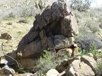
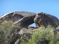
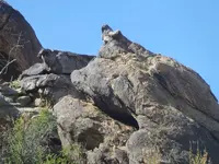
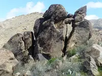
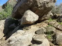
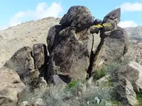
What do you think of these rocks? snake eating.jpgsnake and turtle fight.jpgturtle with pointy nose.jpgsnake eating rocks.jpgsmall rocks under big.jpg Natural or .....

I am very green on using this forum. This software is befuddling...
I had a guy look at these rocks yesterday he didn't think they were anything. They look like they mean something to me.

Let me know experts out there. I am open to help!
 

Wow Klondikesteve. Absolutely spectacular photos. Its rare to see that quantity of photos with all that symbolic images on Tnet. Very very interesting. To me that stuff is in a whole different class. I get the feeling this isnt your first go at this stuff. I need to spend some more time looking those over. I could be wrong about the symbolic images, maybe a hard rock miner set off a blast and those stones just fell in place. But i dont think so. I sure hope you keep posting. Iam loving the fresh air blowing in. Thanks,great stuff.
 

Here is something you may want to consider Klondike, that is to add a water mark or some kind of mark on your photos. There are people on here that will take them for their own personal use and not give anything back. Its your work and your call.
 

There's a hidden peepsite you look thru right where I put the arrows. The right half of monument is a priest, and you look thru where his eye would be. The left side of the monument is actually a hanging bat, but he is not hanging upsidedown, but rather he is rightside up, and his folded bat wing claw is pointing at the priests eye. It basically means covered cave or tunnel (because of the bat) and you look thru the peep sight by the priests eye to see it. If it doesn't show the actual spot (which I'm pretty certain it does), it will show a marker that leads to the tunnel.
 

Attachments

  • snake eating rocks peepsite.jpg
    snake eating rocks peepsite.jpg
    436.3 KB · Views: 87
If the peepsite is closed or ruined, look thru the V directly above it made by the the rocks coming together.
 

Left half of monument is also a squirrel, so its being used , or was being used, as a storage, since squirrels horde/ store their food.
 

Enlarge the photo I provided, the arrows I drew are small and yellow. You can't see it without enlarging it.
 

Sepehr at 9:30 if you have a intrest .

In Greek mythology, Cronus (Saturn) was the leader the first generation of Titans, that ruled during the mythological Golden Age, until he was overthrown by his own son Zeus (Jupiter).
 

Sepehr at 8pm if you have a intrest .

A mother goddess is a personification of motherhood, and is usually equated with the Earth or the natural world, sometimes referred to as Mother Earth or as the Earth Mother. The concept is complementary to a "Sky Father" or "Father Sky".
 

I know, it's a pain trying to do all this with only a compass. :BangHead: :censored:

But whoever did this had less than that, only their Celestial knowledge (which I honestly believe was far superior to a compass). Unfortunately, that's all I have to work with at the moment, and I'm sure my calculations show it, lol. I guess we'll see come Solstice. Sigh.


How did they do it? Pretty simple actually. :wink:


I'll check out David's stuff, thanks.

For some reason, Cort Lindahl's old axis mundi videos went "private" on his YouTube channel. Fortunately, I replicated many of his great circle lines on Google Earth. Incredible geometric connections. Now most of his research is genealogical, linking the family histories of some famous US treasure legend, which is intriguing to say the least, but I miss the map work.

Thanks to Lindahl, and some cool stuff from mdog, I began drawing lines between certain things, just to see what came up, or where certain azimuths connected to and passed through along the way. Here's a couple distant nodes that have some unexpected "coincidental" correspondences.

View attachment 1817087
Follow the red line

View attachment 1817088
The KRS is an important control point in North America

Here's one especially for Dit and Ken, who place importance in Tres Hermanas - rightfully so? Remember, when you find something of interest on the ground, always get its coordinates. As above, so below.

View attachment 1817089


A complicated, sometimes arduous to follow presentation, but there are several key take-aways to be found here. Chief among them the concepts of a Geographical Landscape as a Geometrical Landscape, Geological Landscapes as Astronomical Landscapes, and the Combination of the Two.

Worth a listen, be sure to pay close attention near the end.


Man o Man, I have to say thank you to Sdcfia and OK. You guys triggered all kinds of stuff in my head now. It was like getting slapped right between the eyes. The space port photos,the 33deg line and now that triangle that Sdcfia posted. There is one of those seed pods that show up in Cookes range, a large shadow form. So i also take it that the Butterfield trail follows along the 33. That triangle is very interesting Sdcfia. I wonder what 12 circles would show with the center point being Cummings Fort and the spacing being the diameter of your 3 points? That curve of the Rio right there is also very interesting. I need to go back to Fort Cummings and get me a couple gallons of water and think on things. Thanks.View attachment 1817152


I keep hearing all these references to a "King's Trail" when perusing the Treasure Marks & Signs forum. :icon_scratch:

The Real 'King's Trail' is much older than some would like to believe, and predates the Spanish by thousands of years.

" The Royal Road of the King of the World is a 20-degree band around the Earth that has 30 degrees north latitude as its center. This band is not, technically, the geographical center of the Earth, which is marked by the equator. But when the square miles of land south of 30 degrees’ north latitude are counted together (not including the Arctic or Antarctica), and the square miles of land north of 30 degrees north latitude are similarly tabulated, both equal approximately 26 million square miles. Thus, the Royal Road of the King of the World exists at the very center of Earth’s landmass. In ancient times this central region was denominated by many civilizations living upon it as the “Center of the Earth.” "


The Royal Road of the King of the World, and the Ancient Center of the Earth


:coffee2: :icon_study:
 

Ditlihi said:
I know, it's a pain trying to do all this with only a compass.

But whoever did this had less than that, only their Celestial knowledge (which I honestly believe was far superior to a compass). Unfortunately, that's all I have to work with at the moment, and I'm sure my calculations show it, lol. I guess we'll see come Solstice. Sigh.


How did they do it? Pretty simple actually. :wink:


Maybe the panel carving in your photo on post #4 had the Solstice degrees you needed all along. Worth checking out. :dontknow:


ex6frnVl.jpg
 

Status
Not open for further replies.

Top Member Reactions

Users who are viewing this thread

Back
Top