accounting for the 1715 fleet vessels by their own " offical records"

Re: accounting for the 1715 fleet vessels by their own " offical records"

Thanks, Goldminer..that's the reference I read somewhere. Crossing the southern Bahamas, the storm likely followed the warm waters of the Florida Current for a while. If so, it intensified from the warm water fueling the storm.

I personally concur with Ivans assessment of the track 100%, especially considering the south Bahamas report. However, we're all just speculating.
 

Re: accounting for the 1715 fleet vessels by their own " offical records"

Ivan, I think you are right that the storm could suck a vessel down and into the eye but i do not believe it happened on 1715 and here is why....

If the fleet was in the open Atlantic then yes maybe what you said could have happened but they were in the most dangerous places to be caught in a storm, between Florida and the Bahamas and the Spanish knew this. They tried to sail away from the coast but were unable to because they could not tack to port or they would have hit the Canaveral Shoals and they could not tack to Starboard because of the strong winds. According to Salmon they raised the storm sails but the wind blew them away, their masts were broken and the rudder gone he dropped two anchors in 12 fathoms of water but they dragged until they were thrown on the the reefs at Palmar de Ayz in 4 brazas of water.
No where in the archives does it even hint that they hung out in the eye of the storm. Salmon gives a time line of what happened, he said that at 2:00 am he sunk and that the capitana was 4 hours earlier. At the time of their sinking the winds were at there height from the ENE. If they were in the eye the winds would have been calm for sometime. According to Lima he lost his masts and also his rudder but i do believe that Lima was in the eye because his ship was the only one that stayed intact and Lima hints at the fact there were more than one storm. Lima's ship sunk at 10:00 am the next morning.

Due to the fact the ships were in the channel they had no room to maneuver and yes they were sucked down from the Cape to where they were destroyed but they fought the storm and the seas and never experienced the eye only the eye wall. There was just no room for the ships to get out of the way or to "Lull" around for a day or two..... I also believe they grounded the ships on purpose once they knew they were doomed....

The Hurricane could have taken a path a few points to the NW but not to much or the scatter pattern would not fit the wind pattern. The storm had to come from a easterly direction but not necessarily due EAST and the eye had to pass south of Capitana and Almiranta... The Florida Coast where the wrecks happened is running on a NW to SE direction. A storm coming from the east would appear to be more SE if you were standing on the beach watching it come in. The way the wrecks are scattered on the sea floor tell how the ship broke up, it also tells what direction they broke up in, no matter what we believe happened.

To Find the answer to "What direction the storm came in" we have to answer why is the scatter trail dispersed the way it is.....


Happy New Year!!!!!!
 

Re: accounting for the 1715 fleet vessels by their own " offical records"

Another historical document I reviewed stated that some of the ships were intact or in larger sections, but during subsequent years, repeated hurricanes and storms broke them up and scattered the wreckage. What I would ask Goho, is if the wreckage that appears to be running NW is just the "lighter" smaller stuff, or are any of the heavy pieces running that direction ?

itmaiden


GOHO said:
To Find the answer to "What direction the storm came in" we have to answer why is the scatter trail dispersed the way it is.....

Happy New Year!!!!!!
 

Re: accounting for the 1715 fleet vessels by their own " offical records"

signumops said:
Previously, I wrote that I thought the storm was very large and I still think that it re-organized over the Bahamas and really built a huge circulation. In my first illustration the eyewall is about 112 miles in diameter. As the center of circulation approached the fleet, as seen in the next illustration, the northern-most vessels were driven ashore in a shorter period of time, while the souther-most members of the fleet were probably driven to shore on a more exaggerated tangency than those toward the north. It would be hard to illustrate this without resorting to animation. Its important to remember that the winds in the forward-right quadrant of the storm are the firecest (I messed up my explanation of this in my previous post... I was thinking of a north-bound storm at the time, not one on the path I illustrate here).


Moving at 5 miles an hour, it would take about 24 hours to pass the area of Vero as seen in the next illustration. Therefore, if Echeverz was really at the Popa, which I think was probably in the area of south Vero Beach, he would experience a 'second storm' a day after being wrecked. If a ship was below the east-west plane of the storm, it has more of a tendancy, in this model of being swamped further from shore. What does this mean for the vessel supposedly lost below the present-day Hutchinson Island power plant ????


The rear action of the eye-wall is definitely the one of interest! The rear eye-wall did what the forward eye-wall did not do... it spread wreckage back out into water that could support the reduced weight of the shattered timbers, floating bodies, boxes, hull parcels and baggage. This means that we can continue to find more treasure in subsequent explorations. That's why this whole study is worthwhile.

Your sketches illustrate it perfectly. Depending on the angle of the hurricane coming to land and the ships positions in respect to it, they could be pushed down to the South, out to the East or NE, or NW to West.

Anything that floated out to the SE, E, or NE before sinking would then stand a chance of getting pushed to the N by the Gulf Stream.
 

Re: accounting for the 1715 fleet vessels by their own " offical records"

A lot the information here is third party based on some one else's opinion or writing (i.e. book). I would like to see original documents from the Spanish salvagers... A lot information is lost in translation especially when working with old documents.

Who can read 16-18th century Spanish in Florida today?
 

Re: accounting for the 1715 fleet vessels by their own " offical records"

Laughed at ? No. That has been a subject around here more than once. However, a recent historical document I have ran across pretty well suggest that most of the ships were accounted for to some degree except for 2 that sank in deep water. There were a couple of ships obliterated, though unknown to many, there was some salvage off of those ships apparently. I have to do more research on this document and the author though.
The author did a lot of historical writings back in his day.

Now as far as the Lagoon, I know of debris in one area that spans a fair distance but it is under lease already. I was also examining what looked like some debris in another part of the Lagoon last night, but you got to understand that this Lagoon has been used for Steamboats, Fishing Boats and Recreation for a long time, and there is some junk in it.
You can always take the risk of diving in it with a MD and hope a boat motor doesn't clip you in the process, but as far as fulls size ships, I haven't seen any yet. They would have to be well under the sand. However, the ships of the fleet that would have had the most opportunity to end up in the Lagoon have been well accounted for and heavily salvaged and one is being salvaged right now.

If you don't mind the gators and crocs...go for it, just not in mating season (around May).
And stay away from state protected areas.

However, PcolaBoy, Pensacola is a prime area, especially in that bay up there.

itmaiden

PcolaBoy said:
Since I'm located on the north-central Gulf Coast, i've spent most of my time researching local colonial wrecks. However, as of late I've begun taking a strong interest in the 1715 fleet.

At the risk of being laughed out of the forum for suggesting it, has anyone considered the possibility that one or more of the ships, or siginificant chunks of them could have been carried over dunes between Lucie Inlet and Ft. Pierce and deposited into the Indian River?
Pcola
 

Re: accounting for the 1715 fleet vessels by their own " offical records"

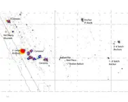
Here is the Cabin Wreck Map i said i would post when i returned home. I tried to post it with the aerial photos and NOAA chart attached but the file is way to big. This map shows only the Mag Targets and i have labeled what the larger targets are. If you notice the 9' Anchor it's pointing 190 degrees right to where the broken ballast is. This is the impact area where the ship first started to come apart. the Ship then moved east and south east then followed the beach north.

The Hurricane in the early hours of the storm had winds from the NNE or 10 degrees.... Only a storm moving in an EASTERLY direction has winds from that direction.....
 

Attachments

  • CABbase map 09-Model copy.jpg
    CABbase map 09-Model copy.jpg
    56.5 KB · Views: 2,066
Re: accounting for the 1715 fleet vessels by their own " offical records"

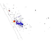
Here is the same map only this one is overlaid with ballast stones (black circles) and Silver (blue circles) and Gold (red circles) each circle is the size of a blow hole (approx 18' dia).
 

Attachments

  • CABbase map wsilver.jpg
    CABbase map wsilver.jpg
    34.3 KB · Views: 1,901
Re: accounting for the 1715 fleet vessels by their own " offical records"

Here is one more map of the mag targets overlaid onto aerial photos..... here you can see how the material is scattered on the reefs.... I am trying to show as much as possible without giving away all my secrets....
 

Attachments

  • CABbase map photos.jpg
    CABbase map photos.jpg
    111.8 KB · Views: 2,261
Re: accounting for the 1715 fleet vessels by their own " offical records"

OK, here is the cabin mag map overlaid on the aerial and only silver, gold, and ballast stones showing..... The anchor with the 9' shank is upper left in the black background.......
 

Attachments

  • CABbase map photosilverl.jpg
    CABbase map photosilverl.jpg
    109 KB · Views: 2,759
Re: accounting for the 1715 fleet vessels by their own " offical records"

If you look closely at the blue circles (silver) as you move north along the beach you can see trails of silver leading back out to sea... this happened when the winds from the storm were out of the SW and W...... Thats why Salmon said that nothing from his ship washed ashore.... it was blown back out to sea!
 

Re: accounting for the 1715 fleet vessels by their own " offical records"

Hey GOHO:
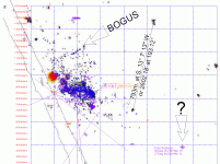
Appreciate your magmap! I rectified it to State Plane and put it into my system and overlaid a grid and a digitized mag map from the Rathman group from way back. Its purple in the pic below...

GOHOPICOVERLAID.gif

If I follow you, you say the anchor shank is laying about 190 degrees... I set that out from what I assume is the mag symbol for the anchor and traversed the line to what would be the cracked ballast... Do I have it right?

I don't believe that data in the line going to the N.E. I think Roy Volker did that reporting and I think there may have been 'errors' in that.

The big questionmark hit is about 30 feet of water. Nothing there visible but grass.

In this illustration, it looks like the boat hit bottom then went a little north of west toward shore (?) That does not jive with the touchdown at the cracked ballast if we are right about the path. Otherwise it looks like the cracked ballast were some that were dropped while the boat was moving to the S.E. from inshore...
 

Re: accounting for the 1715 fleet vessels by their own " offical records"

The trail of silver heading back out to sea is not Bogus... I dug there myself and found coins leading out to sea in 30' of water..... i admit that some excavation holes are bogus because Roy Volker and others thought they were sneaky and put wrong numbers down where they worked....


Nice job with the overlay....
 

Re: accounting for the 1715 fleet vessels by their own " offical records"

Where the broken ballast is is a reef that comes off the bottom 3' or so.. i found timbers and other artifacts wedged in and around that reef.....

Salmon stated that his ship broke into 3 pieces..... remember that where everything is lying is where it came to rest after the storm passed... Some of the ship could have tumbled and rolled south of its present position. The key is that the winds shortly before the ship sank was NNE.

Check this animation out of Hurricane Jeanne....
http://www.sun-sentinel.com/news/local/southflorida/sfl-2004-jeanne,0,3954334.story
 

Re: accounting for the 1715 fleet vessels by their own " offical records"

I think the storm that came toward the fleet from the lower southeast quarter -- wrecking the fleet as it approached it then stalled off shore as it approached the wrecksite area for a day (causing a day of decent weather as the wreck area was basically in the eye of the storm) however once the the storm rebuilt itself --it then headed northward going along up the coast, hitting st augustine . the north bound rear wall of the storm as it went past the wrecksites would suck wreckage debris out to sea via the counter clockwise winds , wave action and tides --and cause sands to shift off shore as well covering some of it.
 

Re: accounting for the 1715 fleet vessels by their own " offical records"

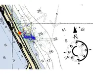
Here i marked the most obvious directions that the wind had to blow, i also added a compass rose with magnetic north to help with direction, the NOAA chart adds water depth as well....
 

Attachments

  • CABbase map 09-ModelNOAA.jpg
    CABbase map 09-ModelNOAA.jpg
    149.3 KB · Views: 1,777
Re: accounting for the 1715 fleet vessels by their own " offical records"

thank you goho---- as you can clearly see via your overlay the wave action from the hurricane came from the E - SE direction or from below the vessels right hand lower quarter --(for a north bound vessel running up the coast ) the counter clockwise blowing winds would make it impossibile to run north as the storm approached the fleet ,since the wind would be pushing any ships trying to go north back south into the front of the storm. ---as the storm closed in the ships turned their bows in the direction of the approaching storm in hopes of dropping anchor and riding the storm out as it closed in but it was too strong -- and they were blown into the shallows and wrecked
 

Re: accounting for the 1715 fleet vessels by their own " offical records"

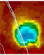
Here is Hurricane Jeanne just as the storm came ashore. I believe a storm with a simular path is what wrecked the fleet. Notice that Lima's ship if it is in St lucie would have "Fared the best because of its location". Lima was in the eye of the storm no doubt but i believe the rest of the fleet fought the winds non stop until the storm passed. Here is an example of Hurricane Jeanne coming ashore and notice the cabin wreck being north of most of the other ships. The winds drive everything ashore then blow it northward.. Thats the only explanation i can find to explain the scatter of the wreck and coinside with the archival research.
If anyone has any other ideas i really would like to hear it, thats why i am giving all this info out... I think together with new ideas we will discover new things....
 

Attachments

  • CABbase maphurrican copy.jpg
    CABbase maphurrican copy.jpg
    131.5 KB · Views: 1,576
Re: accounting for the 1715 fleet vessels by their own " offical records"

ivan salis said:
thank you goho---- as you can clearly see via your overlay the wave action from the hurricane came from the E - SE direction or from below the vessels right hand lower quarter --(for a north bound vessel running up the coast ) the counter clockwise blowing winds would make it impossibile to run north as the storm approached the fleet ,since the wind would be pushing any ships trying to go north back south into the front of the storm. ---as the storm closed in the ships turned their bows in the direction of the approaching storm in hopes of dropping anchor and riding the storm out as it closed in but it was too strong -- and they were blown into the shallows and wrecked
 

Re: accounting for the 1715 fleet vessels by their own " offical records"

see the arrow by the 32 --that is the general track (direction) of the hurricanes approach with the storm surge / wave action -- the arrow by the 41 shows which way the counter clockwise winds would be coming from off the hurricance . blowing southward --- thus preventing any escape to the north * ---to the east was land and to the west of the fleet the storm -- south was no good either -- thus they were trapped and pinned in .

the north facing arrow is which way it went after it stalled offshore and rebuilt and headed northward up the coast along the hurricanes new track --as it went north it sucked sand and debris from the wreck areas offshore as it cut the beaches -- thus the west facing arrow .

remember how there was a hurricane type storm stalled below jacksonville this year for 4 days ? --

think if it had wrecked a fleet as it approached land --then stalled offshore and rebuilt before moving on to the north, eh?
 

Top Member Reactions

Users who are viewing this thread

Back
Top