accounting for the 1715 fleet vessels by their own " offical records"

Re: accounting for the 1715 fleet vessels by their own " offical records"

The official Record, strange but true.
Because King Phillip lost this dowry on 3rd. attempt he decided then to pull out of the America's.
So then governments then decided to take over the native land.
Today, January 12th., 2010 is 15 years to the Date I found the Carribean origin stone with the anchor carved into it with the circle carved around the anchor. Maybe was supposed to be the Vatican,mark, anchor but resembles more of the Catacombs, mark, anchor.
Florida was founded in the "Spirit of Saint Dennis" in what is today's,ghost town Astor, Georgia. There is an Astor, Florida today.Saint Dennis was the patron saint to psi experience, and dejuvu magics.
"Two friends put a painting on a wall and swore never to take it down until one or the other dies. As 1 of the friends lapsed into death on his deathbed one day , the painting fell off the wall on it's own accord. This is known as PSI Experience Magic", From Man Myth and Magic.
Dejuvu is also like everything you have seen it seems you have seen it before.
So, maybe the Tropical Storm Gordon that stalled off the Florida coast, and sent 19 foot waves crashing to the shore from 11/94-01/95 has a similar tie in with the condition that existed at the time of the sinking.?
*John Hancock. Born 01/12/1733.
*The Arizon',Belem,and Rubi sunk in that year too; 07/07/1733, but maybe a coincidental Thing . :thumbsup:
Todays featured article posted 01/14/10 EST but reads for the Date 01/15/10 ; http://en.wikipedia.org/wiki/Wikipedia:Today's_featured_article/January_15,_2010
 

Re: accounting for the 1715 fleet vessels by their own " offical records"

Watches existed back then. Some have been found on wrecks.

[[url]http://www.atmos-man.com/historyo.html#_Toc411179457/url]

itmaiden


FISHEYE said:
If there was a timeline on which ships sank first.How did any people come up with this timeline in 1715 when all they had for a clock was a sun dial.A sun dial only works when the sun is out,not when you are in the middle of a hurricane.Has any sun dials been recovered from any of the wrecks?
 

Re: accounting for the 1715 fleet vessels by their own " offical records"

my thoughts - storm approaching from east (see Greg's postings) :

Escribania de Camara 1058C - Don Miguel de Lima y Melo in Havana to Duque de Linares, dated 19 October 1715. "Arriving after 3 days at the mouth of the Bahama Channel, when night fall came this same day we had 'Los Roques' is sight and at daybreak the following morning we were near the head of the Florida Keys (Key Largo or Key Biscayne) which was opposite of us off our beam. And continuing we coasted along the cayos and the mainland of Florida, however, always with very light winds, having to tack until we were forced to lay to (without sail), for the motive of still trying to incorporate Echeverz Squadron which always sailed at a distance from our Flota.
We were in this position when the wind began to blow fresh from the ENE and taking a sounding we found we were in 50 fathoms of water. We were advised by the Capitana, by a cannon shot and flags, to use what sails we could and head away from the coast until we were in deep water. But we were unable to do this because the currents were pushing us towards the shore and the winds were getting stronger, as being from the wrong direction for getting away from the shore. ....The sun disappeared and the wind increased and increased in velocity coming from the east and ENE"

So picture this - the Flota is in the lead or at least out of sight of the Galleones of Echeverz .. they are "laying to" when the wind starts to pick up - the Galleones were either behind or parallel but the Capitana and Almiranta (Rio Mar and Sand Point) end up wrecked north of Lima - whether you believe that Lima was wrecked at the mouth of the old Ft. Pierce Inlet or at the St. Lucie. The ships supposed to be so far behind that the Flota was laying too ended up ashore north of one that was close enough to get the signal of the Capitana of the Flota.


Hurricane had to come in from the east - Echervez' squadron on the starboard tack further to the East / SE- wind picks up - lighter smaller ships can sail to windward (point) better and so escaped somewhat to the north - some being caught and sinking off the Cape or the edge of or in the Stream - the heavier ships end up driven into shore as the hurricane comes further West but the earlier strong easterly winds have enabled them to beat enough to the north to pass the ships of Lima and some of the Flota
 

Re: accounting for the 1715 fleet vessels by their own " offical records"

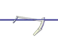
Here is an example drawing of the anchor with a 9' shank that i found in 2003 on Cabin Wreck. The top fluke is broken off and gone but the ring is intact but lying downward as if the tension of the line was let loose. The Anchor points the best i can figure 190 degrees. The anchor is dug into the mud very deep as if it was being dragged through the bottom. I definitly believe this was a small anchor that the Almiranta used to try and hold themselves away from shore.
 

Attachments

  • Anchor SE3D.jpg
    Anchor SE3D.jpg
    25.7 KB · Views: 907
  • Anchor 3D.jpg
    Anchor 3D.jpg
    26.8 KB · Views: 907
Re: accounting for the 1715 fleet vessels by their own " offical records"

Direction of the winds versus direction of the Huricane. If the Hurricane was coming from the North, the lower bands would hit first. Counterclockwise lower bands would appear to be blowing southward, from the west and to the SE. If the storm is coming from the East, depending on where you are in relation to the storm, the bands could be blowing southward, from the NE, westerly or to the SE. If the storm is coming from the SE the upper part of the bands would appear to be blowing from the East and NE.

itmaiden


capthawk said:
my thoughts - storm approaching from east (see Greg's postings) :
 

Re: accounting for the 1715 fleet vessels by their own " offical records"

Just imagine the force that it took to break off that fluke of the anchor.Has that fluke ever been found?I bet its out on the 3rd reef or even further out.
 

Re: accounting for the 1715 fleet vessels by their own " offical records"

I would guess that corrosion and erosion is what weakend the fluke then probably a fishing net took it away....
 

Re: accounting for the 1715 fleet vessels by their own " offical records"

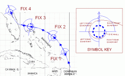
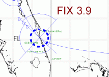
OK, Goldminer and BillinStuart found sources for storm passing over Domincan Republic. Tom and Ivan cite the storm ripping through St. Augustine. Nobody says anything yet about Freeport or any storm there. So...

1715STORMONE.gif

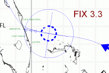
Fix 3 above is about where doldrums stopped and breeze picked up. We are interested in what happens between Fix 3 and 4. Next illustration shows position Fix 3.3 where storm stalls, and circulation equalizes while spreading out from the center. Boats at 28 degrees of latitude are definitely getting a headwind. Whole fleet is being blown south while those in the right front quadrant are being blown south and coasted by current, as well.

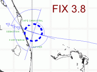
1715STORMONEMORE.gif


Storm organizes and begins to move toward landfall at Fix 3.8. IF landfall is as shown and eyewall is at least this big, then Corrigans Patch bites the big one at Wabasso and is wiped southward along the beach for several miles as the tangency of the eyewall vs the slope of the shoreline presents the widest swath of storm front. Meanwhile boats north are dashed to shore from the N.E. to S.W. initially. Southend boats, like Douglas Beach are on a much longer tangent. Landfall central is about Vero. Rio Mar vessel pushed straight to the rocks. Sand Point vessel goes in with a tangent similar to Douglas Beach wreck.

1715STORMTWO.gif

Now, lets deep six our voodoo belief systems and all agree that there were not two hurricanes striking the same place on two subsequent days. Didn't happen. Storm is lingering on landfall, which is typical while overcoming termperature differences. Boats are on shore now (or swamped) and being pounded by surf. Finally storm's rear quadrants pass over the victims, pulling wreckage away from shore.

1715STORMTHREE.gif

Using this model, maybe we get a different idea about which wreckage is which ship... maybe... and where to dig offshore.
 

Re: accounting for the 1715 fleet vessels by their own " offical records"

Signumops,
That was an excellent evaluation and presentation of the most likely hurricane scenario. Without doing any in depth analysis on my own, it presents clearly what I always felt in my gut.
Aquanut
 

Re: accounting for the 1715 fleet vessels by their own " offical records"

Thank You, That was a great example of how i think the storm traveled too, the only thing i don't agree on is the eye position... i believe the eye of the storm was closer to St lucie... Capitana and Almiranta never encontered the eye only Lima....
 

Re: accounting for the 1715 fleet vessels by their own " offical records"

Jose Millas says: “ 1715….. This hurricane is not mentioned in any catalogue of hurricanes. According to these records, no hurricane occurred in the year 1715.”
Fernandez Duro gives a good account of the fleet loss, however. Don Dioniso Alcedo gives the same date as Duro for this disaster, and according to Sheppard (1810) “ All the cocoa trees in Santo Domingo were destroyed.”
Given this evidence, Millas then says, “ This hurricane crossed over the seas north of the Province of Oriente, Cuba, and the southern Bahamas, moving in a west-northwesterly or northwesterly direction.”
That being said, I think we can rule out TWO hurricanes on successive days.
Terry, could you use the same charts that you have posted, and place the known wrecks where they now lie?
 

Re: accounting for the 1715 fleet vessels by their own " offical records"

Back in 1715 hurricanes wernt called hurricanes.They were called "the tempest" or "great gust","great storm",hurry cane","tremendous storm","the fury of the elements","Very copious rains" and "equinoctial winds","undiminished violence","September gales".Our word "hurricane" comes from words used for these storms, or storm gods, by people who were living around the Caribbean Sea when the Spanish arrived in 1492.

Most likely there was no hurricane that destroyed the 1715 fleet since none are on record anywhere.It could have been a sub tropical storm.These still rotate just like a hurricane but with lesser winds up to 70 mph.


records of Atlantic hurricanes from Spanish documentary sources
http://www.ucm.es/info/tropical/data.htm

Good info links.
http://www.hpc.ncep.noaa.gov/research/roth/va18hur.htm

sediment records for past hurricanes.
http://www.nytimes.com/images/2001/07/24/science/sci_STORM_010724_00.html

http://stormcarib.com/climatology/

http://www.usatoday.com/weather/hurricane/history/hurricanes-deadliest-since-1492.htm

http://weather.unisys.com/hurricane/atlantic/
 

Re: accounting for the 1715 fleet vessels by their own " offical records"

Hey Fisheye:
I don't buy the Millas story completely... that would put the storm moving IN the Bahama channel, which would mean the fleet was overcome from the south. I assumed that for many years myself. Bill Moore says it came from the north. I don't see how, honestly, strictly from the statistical improbability. But, the effect of a northerly wind in the right front quadrant of a storm moving westward with the eyewall to the south of a boat would give the pilot the impression that the storm 'came from the north'.

I've been coinshooting at the HRD beach area during a tropical storm and I don't think that a whole boat could have been thrown ashore, sum total, in a tropical storm. 120 mph hurricane would definitely be able to do it if the storm front was plowing in perpendicular to shore. The number of people killed on Ubilla's ship, in view of its very close proximity to the shore, leads me to believe this was at least a cat 3, probably more like a cat 4. You can see by the displacement of the ballast that the boat was severely beaten and rolled around in a remarkably small area. That all happened initially during the storm itself. Later on (years or centuries) the hull bottom ended up on shore.

As for the actual landfall, well that might be far south at St. Lucie, but, I think that if that were so, and the track I just illustrated was correct, then the eye wall would have been much bigger than illustrated. There is that missing vessel approximated to be at least some miles south of the Hutchinson Island power plant (I pinned that down in a previous post, but can't remember the exact location I plotted). And how about the Rex Wreck at the Melbourne Beach radar site? Did it just swamp? Or did it come to shore and then get rolled out? Don't know enough about that one to even say for sure that its one of the missing boats, but, maybe we need to start looking near shore and to the NORTH of that spot to see if anything is at the beach.
 

Re: accounting for the 1715 fleet vessels by their own " offical records"

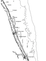
Here is a map showing all known 1715 sites..... I believe the Cannon site is a piece of Corrigans.....
 

Attachments

  • EASTCOASTSHIPWRECKS-Model.jpg
    EASTCOASTSHIPWRECKS-Model.jpg
    72.7 KB · Views: 1,475
Re: accounting for the 1715 fleet vessels by their own " offical records"

Maybe why theres no record of a hurricane in the atlantic in 1715 is cause the cane originated in the southern gulf and came across land.Tornados and water spouts come with hurricanes,maybe they did more damage to the ships than just the wind and waves.
 

Re: accounting for the 1715 fleet vessels by their own " offical records"

Hey Greg:
Thanks for the map. I know Goldminer would like to see them under my plot, but my map is too coarse to get all those sites labled using a hurricane tracking chart as a background. Besides that I corrupted the file. When I redraw it, I will use a metafile background of some sort so I don't get grainy when I zoom in.

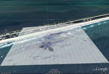
BTW, here's a rubber-sheet view of the Ullian/Clausen map of the Cabin wreck in perspective, looking west.

cabinrubbersheet.gif
 

Re: accounting for the 1715 fleet vessels by their own " offical records"

Sweet.... You did a great job with that!!!!
 

Re: accounting for the 1715 fleet vessels by their own " offical records"

Here is a look at the inshore cannon scatter of Corrigans.... The cannons are drawn to scale compared to the distance between them. There are more cannons out to sea and also to the north....


The compass is referenced to mag N..
 

Attachments

  • CANNON LAYOUT.jpg
    CANNON LAYOUT.jpg
    16.3 KB · Views: 912
Re: accounting for the 1715 fleet vessels by their own " offical records"

Now THAT's what I'm talkin about!! I did not know there were that many. I wonder how many King, Carr and McKee got?

Reminds me of a story, first-person, about Corrigans via Dirk Fisher. I will put it up later today.
 

Top Member Reactions

Users who are viewing this thread

Latest Discussions

Back
Top