accounting for the 1715 fleet vessels by their own " offical records"

Re: accounting for the 1715 fleet vessels by their own " offical records"

Goldminer... if possible i would like to georefference that 1966 or 67 chart that you displayed... you could then bring into goggle earth or most other mapping programs and get your GPS numbers from it....

I really do not hold alot of faith in the old mag map that Classen did.... they used inferior equipment and they really had no way to position themselves accurately. i have georeferenced his map and overlaid unto all of my data and to be honest it doesn't tell me anything we already didn't know. It might have been top of the line in the 60's but its garbage today.

The Hurricane map shown above i think greatly resembles how the storm came in... i have magged several of the wrecks now and they all have a similar u shape pattern to the debris trail.
 

Re: accounting for the 1715 fleet vessels by their own " offical records"

Hey GOHO:
Goldminer49er did not provide that data, I did.
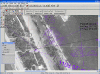
I could not provide the illustrations in my previous post if I had not already geo-referenced the pictures. I use the Tatuk Aerial Image Corrector to setup the world files for the pics and then I put them into my own software to measure, layer, label and examine, ect. I am showing some mag data here furnished by the Rathmann Group overlaid on the 1967 aerial.

goho1.gif

I would give you the file, already rectified, but my world files are always in State Plane Coordinates, so few software packages make use of them directly. But, here is a snapshot with some reference points set out in decimal minute notation if you want to give it a shot. I am sorry that they are not in full decimal degree notation... if I remember correctly, you have to use decimal degrees to rectify an image for Google.

goho2.gif

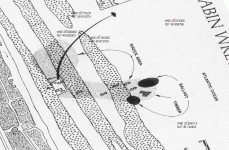
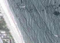
And, as for Google, here is the Clausen-Ullian chart laid over a snapshot of the Cabin wreck site taken July 7th, 2005. The photo is taken from Google Earth (you have to use the history dial-back feature to see this particular shot). The boat that is sitting on the border of the honeypot is your boat. The C-10 boat (the Lobsterman) is the boat I was working on and it is in the lower right of the photo. I guess the Clausen-Ullian chart must be fairly accurate... Yes, No, Maybe? :wink:

goho3.gif
 

Re: accounting for the 1715 fleet vessels by their own " offical records"

One addition to your model....once the storm hit the Florida mainland after approaching from the east, it appears to have taken a northerly direction from there on. According to archival documentation, the same storm hit St Augustine a day or two later.

Don Miguel de Lima to the Duque de Linares:

"The certainty of it is, Sir, that the storm was a very bad one......God permit they have escaped, however within the populated region of La Florida the storm wrought great damage, tearing apart the great wall of the Presidio Castle according to a letter written to me by the Governor of said place."

On another note, would anyone care to speculate where the salvage camp was for the Capitana at Winter Beach? I heard of some intersting artifacts being found north of "F" marker when they were putting in that condominium back around 2000 or so.

Tom
 

Re: accounting for the 1715 fleet vessels by their own " offical records"

I can use any coordinate system or convert to any other coordinate system....

When i return home from my trip i will post my map of the Cabin Wreck. I have magged from shore out to 40+ feet of water. I have probably 1000 to 1500 targets from .25nt to over 1000nt. I used the Geometerics 882 cesium with the mag only 1 to 1.5 meters above the bottom and i ran 25' passes. With all the targets plotted over all excavations you can clearly see the debris trail and how the ship moved and broke up. The Geometerics mag is so sensitive i was able to find single spikes and cannon balls lying in the debris field. All my Lat and Longs and Mag data were recorded usind submetered DGPS at a rate of 10HZ.

I found the impact area offshore in around 30+' of water. There were broken and shattered ballast, timbers and a piece of the keel. I also found spikes, mortar balls, musket balls and ceramics. There is another area of ballast just inshore from the impact area that has probably 5 tons of ballast. Out to see from there i found 4 ketch style anchors which look like they were used to buoy the site. The large anchor i found pointed right to this spot. I didn't find any coins or "treasure" in this area but i still have some excavating to do.


The Claussen map really only shows the cannons and anchors inshore. There are some targets offshore but they had no GPS just beach markers and bouys to mark their position. When i overlay Claussens map onto my own i can see the error clearly.

I will post mine next week!!!!
 

Re: accounting for the 1715 fleet vessels by their own " offical records"

I remember reading an account of the hurricane passing through the lower Bahamas before proceeding up the Florida channel, following the gulf stream. This track would have allowed the storm to intensify dramatically. I still feel that once the ships were wrecked, they back side of the storm, and its winds FROM the west, contributed little to the destruction, but may have spread debris just a little.
 

Re: accounting for the 1715 fleet vessels by their own " offical records"

billinstuart said:
I remember reading an account of the hurricane passing through the lower Bahamas before proceeding up the Florida channel, following the gulf stream. This track would have allowed the storm to intensify dramatically. I still feel that once the ships were wrecked, they back side of the storm, and its winds FROM the west, contributed little to the destruction, but may have spread debris just a little.

Hey Billinstuart

Can you remember where you read that? The whole trick is to know where the storm came from, where it made landfall (IF it made landfall) and where it went. Tom has pretty good evidence that it went north... or, maybe it was actually heading west and made landfall in the False Cape area , or maybe even Edgewater. All sorts of possibilities. I remember that Mitch was so large it produced the biggest waves onshore in the Keys that I saw in a 12 year span, and Mitch was a thousand miles away at the time.

Hey GOHO

Looking forward to it!
 

Re: accounting for the 1715 fleet vessels by their own " offical records"

Dell:
I don't think that I will be working the Cabin. I am more interested in the Wabasso area and Sand Point. Plan to stick with Taffi's grid award strategy and already have one working. There's another 'retired' hunter who has put me onto something.
 

Re: accounting for the 1715 fleet vessels by their own " offical records"

GOHO said:
I can use any coordinate system or convert to any other coordinate system....

Hey GOHO:
I can email the images and worldfiles to you as attachments. Where to?
 

Re: accounting for the 1715 fleet vessels by their own " offical records"

send them to [email protected]

you said it was referenced to State Planes i need to know if it was NAD83 or NAD27 and also Feet or Meters...


Thanks,

Is there a particular coordinate system you would like the photo in?
 

Re: accounting for the 1715 fleet vessels by their own " offical records"

sign, I don't have the reference at hand (hurricane in Bahamas) but it seems like it was an observation from maybe a priest or missionary in the southern Bahamas. I found it on an internet posting/site.

Had it followed the Florida channel, the initial winds would have come somewhere from the east to the north, depending on the exact relation of the eye to the ships.
 

Re: accounting for the 1715 fleet vessels by their own " offical records"

GOHO said:
send them to [email protected]

you said it was referenced to State Planes i need to know if it was NAD83 or NAD27 and also Feet or Meters...


Thanks,

Is there a particular coordinate system you would like the photo in?

Greg:
They are State Plane, Florida East (Zone 901), U.S. Survey Feet, NAD83 (actually NAD83 HARN, but that should make no difference at this small scale). The world files I will send are in that projection.

If you wanted to post them to Google, you'd have to do it, cause I don't really work with KML. Everybody else here might like to see them there. I'd love to see the Fisher Chart set on Google... all the contractors could then use them as they like and I think that it might generate some serious public interest in the contributions of private salvors. God knows that a failure of agreement between Fishers and Florida will be the death of our contracting. NOBODY will be able to dig anywhere if Florida's bureaucrats get their way.
 

Re: accounting for the 1715 fleet vessels by their own " offical records"

billinstuart said:
sign, I don't have the reference at hand (hurricane in Bahamas) but it seems like it was an observation from maybe a priest or missionary in the southern Bahamas. I found it on an internet posting/site.

Had it followed the Florida channel, the initial winds would have come somewhere from the east to the north, depending on the exact relation of the eye to the ships.

Bill:
It would really make a big difference in how things lay to know which direction that storm came from. Bill Moore says it was south-trending. You imply it was north-trending, and so do some other folks here. I always assumed it was north-trending too. But if it was not, then, possibly it was north-trending but passing parallel to the east side of the Gulf Stream, which is about the only solution feasible according to the contributors on this thread. I don't believe a 'Wilma-like' storm passing up the peninsula itself would suck in the ships the way these were.
 

Re: accounting for the 1715 fleet vessels by their own " offical records"

This has been the biggest problem since they found the wrecks in the sixties.... everyone guessing and passing it off as how it happened!!!! I have spoke with several old school hunters and i have come to one conclusion, most have no idea what happened in the fleet....
I write this only because i have done so much work on the sites. I have surveyed the 1715 wrecks more than anyone i know using state of the art equipment. In the old days they magged until they got a hit then dropped buoys and looked for the target, never really doing a good survey and they never were able to accurately map the sites.
I have spent the last 7 years mapping the 1715 sites using a cesium mag running tight passes and not stopping until the survey is complete. The detail that i am able to get using this technique is amazing... Unless you see it first hand its hard to believe. When i plot my targets the scatter trail is very visible and i have verified many of the targets as shipwreck. The cesium is so sensitive that i have found single ballast stones in 30' of water.
What i am getting at is the mag tells me how the ship came in and where the material went, I DON'T HAVE TO GUESS... when i compare the scatter trails to each other there really is only one conclusion on how the storm could have scattered the the wrecks the way that it did. If you look at the history of hurricanes that develop in July and August and compare with how the ships broke up the Storm had to come from easterly direction.......

According to the Spanish archives, one account states that "the sun never rose that day".... and also another states that "the winds picked up fresh from the NE and at the height of the storm the winds were ENE" also they were near the Cape at 28 degrees and were blown down, a southerly storm would have blown them into the cape shoals.

How can a southerly storm create winds like that or scatter the wrecks in a " U " shaped pattern?
The reason many believe the storm came from the south is because some of the wrecks "appear" as though they came in from the SE...... but that's an illusion..........

Hurricanes are very large storms, one could sink the fleet and hit St Augustine at the same time..... i have seen storms the size of Texas!!!!! Remember "Floyd" If a storm was headed north i think it would have sunk the Griffon too but they didn't even know a storm had passed.....

My Conclusion...... The scattered debris trail of the wrecks tells how the ships broke up no matter what people guess happened. Since no one i know has the survey data like i collected all that many people can do is guess. I am sharing alot of info because i enjoy discussing the disaster and everything that i am saying is based on fact!!!! I approached the 1715 fleet with an open mind and let the data tell the story.
 

Re: accounting for the 1715 fleet vessels by their own " offical records"

GOHO: NE winds occur on the NW side of the storm, and the eye will be SE of the location of the NW winds. This occurs if the EYE is moving north, or coming from the south.
 

Re: accounting for the 1715 fleet vessels by their own " offical records"

Think about it... the storm is moving west... if the eye is below me the winds will be N then NE then E then SE then S then SW. Anything above the eye will travel in a "U" somewhat
I sat on the beach during hurricane Jean at treasure shores.... the winds before the storm hit were N and NE, during the storm the strongest winds were E to ENE early the next morning the winds were SE then SW by the afternoon. The eye hit in St Lucie, Sebastian winds were constant never slacked only increased until the next day when the storm passed.

Whats the confussion?

If i was south of the eye then the winds would be different and if the eye hit me then i would have had N then slack then S.
 

Re: accounting for the 1715 fleet vessels by their own " offical records"

Facinating conversation, I hope this thread leads to a "National Geographic" moment for you guys. What an awesome thread.
 

Re: accounting for the 1715 fleet vessels by their own " offical records"

Man Myth and Magic Encyclopedia at the Cocoa Beach Public Library is missing volume 1. This particular volume contains ans Aztec Calender. It could be the magic that has the instrument of the 4o calendar years on it.
While I was reading searches, an interesting fact came up. Earth changes and so do climates because of the changes. This instrument shall give something to go on.
I shall update this when I get the information. Update:01/04/10: At Library now. Have #1 in hand. Dial not in "Aztec" section either. So, back to good old dad. He has it in a storage unit . This could take really long to get because he is on Java. He has the key to it.. :icon_scratch:
Well here is 'sorta' the information 'like' I was looking for. Although this information is correct it is not,!, come from the device that calculates the years to celestial coincidence through the machine I mentioned;
1st January 1715 CE is a Tuesday. 1715 is not a leap year. Based on Calendars, not the instument.
The following calendar years in the range 1715 through 2030are identical to 1715: 1715 1726 1737 1743 1754 1765 1771 1782 1793 1799 1805 1811 1822 1833 1839 1850 1861 1867 1878 1889 1895 1901 1907 1918 1929 1935 1946 1957 1963 1974 1985 1991 2002 2013 2019 2030
 

Attachments

  • stnhng.jpg
    stnhng.jpg
    12.3 KB · Views: 1,682
  • Priest astronomers.jpg
    Priest astronomers.jpg
    45.7 KB · Views: 1,659
Re: accounting for the 1715 fleet vessels by their own " offical records"

At any given time, the relationship of the eye to the wind direction is known (90 degrees), but the only way to tell the direction of movement of the eye is to plot the CHANGE of wind direction. If you tell me "the wind is from the North", the eye will be to the East at that instant.
The coriolis force bends the winds blowing into the eye (low pressure) to the RIGHT. This bending component imparts a counterclockwise spin to the hurricane in the northern hemisphere. That's why they spin counter to what you'd expect. The immediate wind direction is always perpendicular to the center of rotation.
 

Re: accounting for the 1715 fleet vessels by their own " offical records"

the wind, the wind cried the forlorn sailors of old. --- when a hurricane is running due east -- the winds in the area directly in front of it go southward --- due to the hurricanes "counterclock wize spinning action" the winds blow to the southward or "downward" (thus sailing vessels ships caught in the front of it trying to go north or in the top left area in front of the storm would be pushed / pulled downward by the winds - basically being sucked back directly into the "front" of the storm) and also pushed inward as the storm closed in on them ( being it was going eastward) -- thus pinning them to the shoreline --driving them ashore -- if as it approached land fall the same storm stalled offshore for a day (after the fleet was wrecked already) -- thus the "lull" of a day --( the fleet wreck site area was in the "eye" of the storm --then regathered strenght and headed northward along the coast hitting st augustine along its way --( the fleet being hit by the "second storm " or rear wall of the hurricane as it headed northward --- that would give the griffon (who split from the slow sailing overloaded main fleet BEFORE the main storm hit the fleet )---the time it needed to sail north for a day and to then sail due westward -- thus north sailing over the top edge of the strom as it headed east ward --then being to the west of it as it went up the coast later on -- thus they were in perfect position to miss the storm's effects.

I think the storm came from the east / south east quarter towards the fleet -- with its southerly winds preventing them from escaping to the north trapping them into the shallows near shore --after wrecking them it stalled off the coast for a day with them in the eye ---thus having a "lull" for a day --then the rear wall of the hurricane hit them as it moved north --the famous second storm--it rebuilt and the headed north along the coastline --hitting st augustine as well.
 

Re: accounting for the 1715 fleet vessels by their own " offical records"

Maybe this will end some of the speculation about where the hurricane of 1715 came from.
This is from Dr. Jose Carlos Millas excellent work on Caribbean hurricanes.
“Don Dionisio de Alcedo gives the same date ( for this disaster ) [referring to Fernandez Duro’s account of the fleet loss] as the one that we have given, which is also the same one found in the narrative of the Italian traveler in his Relazione e giornale…”

Dr. Millas:

"This hurricane of at least normal intensity, crossed over the seas north of the Province of Oriente, Cuba, and the southern Bahamas, moving in a west northwesterly or northwesterly direction."

According to the historian Shepard (1831, app. XXI): “1715” All the cocoa-trees in Saint Domingo suddenly destroyed.”

Dr. Millas again:

“As small cocoa trees cannot be destroyed by moderate winds, the disaster that occurred in Santo Domingo has to be explained by the existence of a hurricane.

There can therefore be no doubt that a hurricane crossed over Santo Domingo in 1715 .”

From Santo Domingo, crossing over seas north of Oriente, Cuba and southern Bahamas, moving in a west northwesterly or northwesterly direction,THEN hitting central Florida COULD have taken a path similar to Betsy in 1965.
 

Top Member Reactions

Users who are viewing this thread

Back
Top