A GUIDE TO VAULT TREASURE HUNTING (Condensed)

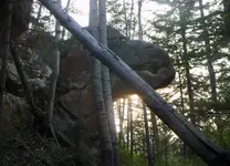
Ahhh, that big boulder is right below what is called "bat cave" to those familiar with the Caballos. A focus of generations worth of attention. Visible from the interstate, if the light is right and one knows where to look. BIG cave.

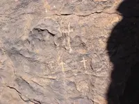
I always figured that the three crosses sign was for Golgotha (of course?), but that the particular one I posted I always thought was more of a shrine to pray at given that it is in a pass. I have found a number of shrines in passes and at old mines, though they tend to be U-shaped rock stacks (critically, with ZERO charcoal in them...)

You said LEFT, so I'll let that win future coin tosses regarding direction unless I feel a "pull" otherwise.

I often can't see what others point out in cloud-gazer type situations. I also think that if I was going to stash a bunch of valuables, the I'd leave Obvious, and Hard to Remove signs (though they would be misleading in some way).

Thus, my interest in putting such signs together with as-verified-as-possible explanations - though, it seems like a consensus among the regulars here is that the "no-kidden" signs are not worthwhile. If this is the case, then my hopes just dwindled.

Though, maybe that we are all right?

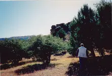
Some years ago, I posted a detailed narrative on TNet of an alleged discovery in the 1960s in that canyon. I was originally asked by the alleged discoverer's nephew in the early 1980s to research the Sierra County Courthouse records to determine current mining claim locations and claimholders in his search vicinity - near Bat Cave and the canyon below it. Later, I got his full story, which was compelling. If you can determine the terminus of the cable run in that area, the alleged discovery was made at roughly the same elevation, not far to the south, in dirt. The discoverer was actively searching for the place, based on the rumors of the time, but the spot he found was apparently a surprise to him.

Sandy1 is correct, IMO, that individual "signs" - rock carvings, monuments, odd landmarks, et al - are not decipherable (there is no King's Code) and will likely only confuse you. Besides, almost all of these things were created for other uses than as "treasure pointers". Your best bet with these things is to get accurate coordinates and plot them all on a topo map. If you find that they form straight lines or geometric patterns or shapes, maybe you're on to something. Or not. Remember, the only one who knew for sure how to use them was the guy who carved them.

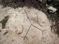
The three crosses symbol is ubiquitous in the southern NM mining districts. They are almost always three distinct and separate crosses scratched near a mine entrance, where the Mexican miners prayed for safety prior to beginning their work day. Your candelabra-shaped carving is pretty elaborate, and unless there was an active mine quite near it, was likely created for some other purpose. Being distinctive, it may be a landmark for someone to have looked for for some reason. How you can use it depends on what it's creator intended, and unfortunately, that information is apparently not available to you. I guess if you found an exact duplicate of it on a map or chart, you might get excited - but remember, you're in the Caballos, where deception, hoaxing and chicanery has a long history.
lascruces.JPG
 

e6ee64a5_1374500.jpg what about these? they were on a ground marker until some1 dumped acid on it and melted it away... i have found two of these markers.this 1 was moved by the kgc,the crows feet and snakes tells where to and how far. the other no feet or snake that is where the heart rock was dug up. i love the owl and the man with wings symbol.what is strange is that the small cross on right is a omega sign with the turkey feet?
 

Last edited:
This is the reason i say go right, large center cross seems to have right pointer on the right,the two smaller crosses, the right one seems to be larger and deeper cut. The pot's right leg has a slash mark. Just a guess. let me know if you want me to delete my posts.View attachment 1458386
 

View attachment 1458332 what about these? they were on a ground marker until some1 dumped acid on it and melted it away... i have found two of these markers.this 1 was moved by the kgc,the crows feet and snakes tells where to and how far. the other no feet or snake that is where the heart rock was dug up. i love the owl and the man with wings symbol.what is strange is that the small cross on right is a omega sign with the turkey feet?

Nice rock, hadji. Wherever this was found, what I notice are two things: the turkey tracks and the Native American profile. It certainly doesn't resemble a mine shrine.
 

both in missouri,hundereds of holes dug all around this marker in the direction of turkey feet. we knew of drill holes in area already from talking with landowners so went home google earth and flipped marker and the drill holes were in line with marker.so after wondering how we got there measured snakes and holes appeared related to lenght of snakes, slash meant add 1 third more in distance to right side and that was location of second drill hole.that lead to this marker.native american marker is actually the owl marker looking at bird beak pointer to right.aaaaaaaaaa.jpg this marker fooled us for years until we realized that the eye was actually a drill hole that they chopped up? why,because they moved it from the original cave it was in to new spot.
 

View attachment 1458332 what about these? they were on a ground marker until some1 dumped acid on it and melted it away... i have found two of these markers.this 1 was moved by the kgc,the crows feet and snakes tells where to and how far. the other no feet or snake that is where the heart rock was dug up. i love the owl and the man with wings symbol.what is strange is that the small cross on right is a omega sign with the turkey feet?


Very interesting, hadji. You may have something with this site....

IMG_20170605_173507_zpsfiqb3xmm.jpg
IMG_20170605_173304_zpsbj38nfqt.jpg


In Cherokee, " gu da " = hidden


Good luck! :icon_thumright:
 

Rock hopper, post 813

Starting where you took the photo get a compass bearing and carefully place survey flags in a line

get little survey flags to keep your line straight--then look back as you go to ensure your lines are straight,

after you have one line use some markers from the clearing and come in at a different angle--you will have to check this second
line from the location you originally took the photo.

Then from that clearing in the distance come in with a third line.
for all three lines you will want an enlarged photo in hand

As your second and third line come into your first line--it should give you a small search area.

Barton
 

Some years ago, I posted a detailed narrative on TNet of an alleged discovery in the 1960s in that canyon. I was originally asked by the alleged discoverer's nephew in the early 1980s to research the Sierra County Courthouse records to determine current mining claim locations and claimholders in his search vicinity - near Bat Cave and the canyon below it. Later, I got his full story, which was compelling. If you can determine the terminus of the cable run in that area, the alleged discovery was made at roughly the same elevation, not far to the south, in dirt. The discoverer was actively searching for the place, based on the rumors of the time, but the spot he found was apparently a surprise to him.

Sandy1 is correct, IMO, that individual "signs" - rock carvings, monuments, odd landmarks, et al - are not decipherable (there is no King's Code) and will likely only confuse you. Besides, almost all of these things were created for other uses than as "treasure pointers". Your best bet with these things is to get accurate coordinates and plot them all on a topo map. If you find that they form straight lines or geometric patterns or shapes, maybe you're on to something. Or not. Remember, the only one who knew for sure how to use them was the guy who carved them.

The three crosses symbol is ubiquitous in the southern NM mining districts. They are almost always three distinct and separate crosses scratched near a mine entrance, where the Mexican miners prayed for safety prior to beginning their work day. Your candelabra-shaped carving is pretty elaborate, and unless there was an active mine quite near it, was likely created for some other purpose. Being distinctive, it may be a landmark for someone to have looked for for some reason. How you can use it depends on what it's creator intended, and unfortunately, that information is apparently not available to you. I guess if you found an exact duplicate of it on a map or chart, you might get excited - but remember, you're in the Caballos, where deception, hoaxing and chicanery has a long history.

View attachment 1458140

I hear you. But.... some of the monuments are much larger and harder to create than any surveyor, miner, or artist would bother with. Others, just too compelling.

If you can't sleep, read the BLM GLO original MTRS survey records. I poured through them for a while and all I found was one apparently undocumented Apache raid on a survey party's livestock and an old mine called the Quen Quen that seemed worthy of more research. Point is: the surveyors alone left "piles of stone", "mounds of dirt", and "stacked rock" all over the place. I find it interesting that there are so *few* I run across now.

Nowhere do they mention 12' high limestone monoliths or large Dolmen-style stones of a rock type brought from far away, let alone translatable (though often only semi-literate) inscriptions in Spanish weathered in a way that they are in no way modern. Let alone the stuff that upon discovery, my old-timer friends tell me was subsequently dynamited in short order - not that I can buy into the "people with enough time to just watch random patches of dirt all day" theory (yet?)

Not sure why, but I find folks often want it only one way exclusively after they poke at this stuff for a while - I'm happy to consider there's a variety out there with a lot of different styles and origin points. And, that it might just all be malarkey - but what fun would that be!?

One last thing: I have often been "drawn in" by small stones, placed just right, to interesting spots. Old mine, Indian fortress (breastworks), a hidden spring or shelter cave. Rocks the size of a bread box (what are those). These often stand out from very far away if your eye is tuned just right - wonder what else I walk right by...
 

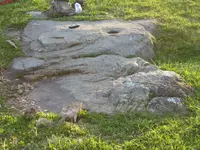
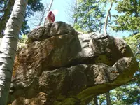
The monuments/markers come in all sizes, big and small. There are alot of big ones left.P1020986 trexrock.jpgP1010489.JPG
 

Attachments

  • 001_1.JPG
    001_1.JPG
    1.2 MB · Views: 121
Last edited:
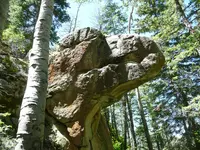
Just waiting for certain members to drop by and tell us how erosion, lightning, and tornadoes created this.

We all know nature does crazy things, so let's all go look for the Garfield (either one, the cat or the president) sculpture.
 

Just waiting for certain members to drop by and tell us how erosion, lightning, and tornadoes created this.

We all know nature does crazy things, so let's all go look for the Garfield (either one, the cat or the president) sculpture.

Oh, no - this is definitely for real. It's part of the famous Richard Nixon treasure heist layout. If you travel in the direction of your Anunnaki's gaze, you'll end up at the RMN shrine. My buddy is paying homage below. Let's see ... where'd I put that doggone shovel?

rmn.jpg
 

Bang! See, that didn't take long ... can't stand anyone seeing something they can't explain (I guess - of course, these are ignored users of the forum, but their negativity is the reason they're ignored) or maybe can't stand someone seeing something they don't want them to see.

They stand as sentinels ... or wannabes anyhow.
 

Last edited:
Bang! See, that didn't take long ... can't stand anyone seeing something they can't explain (I guess - of course, these are ignored users of the forum, but their negativity is the reason they're ignored) or maybe can't stand someone seeing something they don't want them to see.

They stand as sentinels ... or wannabes anyhow.

Gee, Shadow, I guess that's sort of good news for me, as I wouldn't join a group that would have me as a member anyway. By the way - work on your sense of humor a little.
 

LOL!!! Musta hit a nerve ... maybe if I poke him with a stick he'll squeal like a pig (reference to "Deliverance" with Burt Reynolds).
 

It's right on the side of a main trail, faces due north, and looks at markers across a wash about 55 feet away. It has older and newer markings on it. The ones across the wash are likely old spanish but are very large as well. The ones across the wash are about a 100 ton boulder cut to shape like an upside-down heart , and the chunk that was the heart cleft cut out was balanced on a small pedastal near the heart and used as a wedge pointer, about a 4 ton boulder pointing at 330 degrees. Probably too big to mess with the main spots these type lead to.
 

It's right on the side of a main trail, faces due north, and looks at markers across a wash about 55 feet away. It has older and newer markings on it. The ones across the wash are likely old spanish but are very large as well. The ones across the wash are about a 100 ton boulder cut to shape like an upside-down heart , and the chunk that was the heart cleft cut out was balanced on a small pedastal near the heart and used as a wedge pointer, about a 4 ton boulder pointing at 330 degrees. Probably too big to mess with the main spots these type lead to.

All kidding aside, that is an impressive rock. Looks less like any kind of Spanish, and more like Babylonian symbology. Would like to see the other carvings you mentioned. Is that 330° azimuth a rough estimate, or accurately measured? Could it be 337°?

babylonian.jpg
 

It's right on the side of a main trail, faces due north, and looks at markers across a wash about 55 feet away. It has older and newer markings on it. The ones across the wash are likely old spanish but are very large as well. The ones across the wash are about a 100 ton boulder cut to shape like an upside-down heart , and the chunk that was the heart cleft cut out was balanced on a small pedastal near the heart and used as a wedge pointer, about a 4 ton boulder pointing at 330 degrees. Probably too big to mess with the main spots these type lead to.

Yeah too bad they didn't leave a safe secret way,
to get into the big ones with huge heavy traps.
I think the Phoenicians may have liked upside
down hearts, because they look very feminine.
 

Last edited:

Top Member Reactions

Users who are viewing this thread

Back
Top