A GUIDE TO VAULT TREASURE HUNTING (Condensed)

My take on this video is that he found an alpha monument and should follow the trail to the omega location. There will be many markers on the way, but finding the omega is the next step. It will be in the "area" of a mine or treasure or both. On the way to the omega will be a more info and possible a "vista point". A place to view the larger monuments and to see the important clues. Just my opinion.
You are quite right SS and locating one of these monuments is crucial.
 

Attachments

  • 8544521D-1C35-454E-AD1F-A038550DEC4A.jpeg
    8544521D-1C35-454E-AD1F-A038550DEC4A.jpeg
    742.3 KB · Views: 19
Hello my friend. Does the hole created between the stones point to a specific point?
Not my pic so I can't speak for it I know, though it's sometimes possible,
to also look through & see something, maybe part of the big picture.
:
1722530364135.jpeg

The gravel, & in 2nd pic below shows how waves have lapped heavily at times of highest lake levels.
1722530553948.jpeg

Maybe (I hope) sandy1 will get his special team all calibrated sometime soon, & show us more.
1722530628375.jpeg

This area also has a few cut-off cedars for the sentinel's markers too.
1722530364135.jpeg1722530553948.jpeg1722530628375.jpeg
 

Last edited:
1722838072523.jpeg

Once the top rim of a river's ancient canyon walls crowning, winding along a heavily trodden, beaten trail...
1722838281638.jpeg

...Now a perfect land & water paradise for all wildlife, created for preservation of natural resources.
1722838758972.jpeg

With a few turtles, owls, rabbits, ducks, snakes, hearts, crosses, shaft signs & Omegas etc., sprawled out all over the unsuspecting lake park & campgrounds areas.1722838072523.jpeg1722838281638.jpeg1722838758972.jpeg.
 

Last edited:
You have a square notch and a hoyo so you probably have a nearby vault... But it could be a look thru thing or a thing where they set up a place that this is the marked spot to come back to. The elongated triangle shape was used a lot in that it meant divine or God's window, so a window or hoyo that you look thru could have something you see thru it that marks a spot or they could just use the shapes to define a location they were mapping out for more steps to go to a place. It's different time frames on markers but many of the some imagery, so it's not cut and dry on how they were using it on a map.


Nevertheless that picture has 100% imagery/vault marker type things that something is nearby but that may be all you get from it. The rest has to be figured out and it won't likely be cut and dry or straight forward....
It could be straight down the cliff from it , or it could be out in the water as the depths could have changed. I would go by straight below somewhere.... I would doubt it's a coincidence that the hoyo and square notch are natural. They mean something there and something is in the vicinity, I just can't commit to anything too specific. It's just general area and I could be wrong like 10% or so chance on this being natural instead, when I see these shapes it's usually something nearby..... It's worth investigating.
1723306728322.jpeg

Thanks Quinoa, That's right, it's just above water's edge dropping right off now, & was likely a steep cliff back then, when the river ran below.
They did a lot of work all around the area, repeating markers & alignments, like there's more than likely multiple caches. 1723306728322.jpeg
 

Last edited:
1723396070824.jpeg

The Commanche were always moving, patroling, fiercely zealous of their hunting grounds in those days. Often warring with other fierce raider tribes like the Osage & others, roaming those heavily wooded & vast remote areas, leading in & out of the Western Ozark Mts.
1723397252300.jpeg

Sorry a couple more blurry ones, still with interesting shapes placed.
1723397539717.jpeg
1723396070824.jpeg1723397252300.jpeg1723397539717.jpeg
 

Last edited:
1723398801521.jpeg

Even with all of the wild Indian's warring activity, still the Spanish were not deterred to keep pressing always to go on & conquer, for God & King...
1723398886746.jpeg

That's all of the blurry ones of this cove & side of the hills, looking over across, to the next heavily worked hilltops.
1723399024078.jpeg

:
1723399355770.jpeg


1723398801521.jpeg1723398886746.jpeg1723399024078.jpeg 1723399355770.jpeg
 

1723489423823.jpeg

I'll have to get back down there, & take some clearer, & better pics of potential cache indicators.
It's cool just to explore what all they did back then, & it's apparently pretty much still all untouched.
1723489719623.jpeg

:
1723490049738.jpeg
1723489423823.jpeg1723489719623.jpeg1723490049738.jpeg
 

Last edited:
I had first discovered this place in October, Fall of 2015, & was then just passing through...
Didn't see anything out of the ordinary until a return visit in summer of 2016, & did more walking
around exploring the areas. Was reading the very generous & teaching posts & viewing the cool
pics, learning from our good friend sandy1. Sharing the critical Specific Treasure Markers info, all
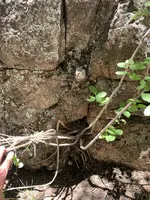
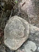
pertaining to Spanish Treasure Vaults. Relaxing, started noticing a little here & there, that looked
unnatural, like it was man made. Walking around the place, looking everywhere, taking lots pics,
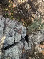
I always see something else, that I hadn't noticed before. But now, after studying with our friend,
is with much more understanding of markers & looking for potential alignments. Enjoying it as
a study, & thought I too would share some neat stuff, like sandy1's had the nerve & generosity.
I know I would still be lost, not knowing or understanding what the Masters of Deception did.
Maybe it will help someone else too! Thanks sandy1, & as always, you're the best! :cross::treasurechest: :thumbsup:
:
1723564954345.jpeg

:
1723565001152.jpeg

:
1723565257823.jpeg

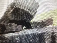
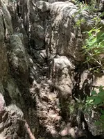
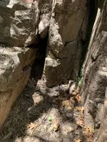
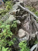
I have a feeling they did something major here, judging by all of the signs leading in & around.
Like a large backfilled rock entrance, that has settled down noticeably through the last centuries...
1723565416640.jpeg

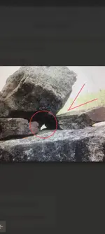
Why did they use the 3 to refer to caches? The Holy Trinity (3) , was considered their greatest,
most Sacred Treasures. Lightning Bolts, a serious warning to be respected, & inform of potential impending sudden disaster, if not carefully observed & understood, & death trap safely dealt with.
1723564954345.jpeg1723565001152.jpeg1723565257823.jpeg1723565416640.jpeg
 

Last edited:
Hey I have been fascinated by this thread. I recently took some photos. Does anyone see anything here. The rock wig the face in the first photo was buried half way in the ground. The next picture is the opposite side. Almost looks like home plate.
 

Attachments

  • IMG_8944.jpeg
    IMG_8944.jpeg
    3.1 MB · Views: 24
  • IMG_8951.jpeg
    IMG_8951.jpeg
    3 MB · Views: 24
  • IMG_8952.jpeg
    IMG_8952.jpeg
    2.8 MB · Views: 27
  • IMG_8954.jpeg
    IMG_8954.jpeg
    2.9 MB · Views: 26
  • IMG_8953.jpeg
    IMG_8953.jpeg
    2.7 MB · Views: 25
  • IMG_8959.jpeg
    IMG_8959.jpeg
    2.9 MB · Views: 25
  • IMG_8962.jpeg
    IMG_8962.jpeg
    2.5 MB · Views: 25
  • IMG_8965.jpeg
    IMG_8965.jpeg
    2.4 MB · Views: 23
  • IMG_8940.jpeg
    IMG_8940.jpeg
    3.2 MB · Views: 24
Hey I have been fascinated by this thread. I recently took some photos. Does anyone see anything here. The rock wig the face in the first photo was buried half way in the ground. The next picture is the opposite side. Almost looks like home plate.
Mu temple complex? Can you post a Google earth aerial photo ? Obscure certain details If you wish your site kept private from the hundreds of unregistered visitors (AKA gov’t snoops, black robes, Archie’s) on this thread looking to get in our business.
 

Last edited:
I went out this morning and found another hill with a lit up marker just below the peak, this is the most common way they marked the storage hills (with a lit up boulder just under a peak) However I have found and shown other lit up markers that were just on the side of mountains as well.

Here is the lit up marker just below the peak.

View attachment 1496992
So much of the good information has been overlooked thank you for posting this tidbit. It has helped me alot with my discoveries.
 

View attachment 2166098
I just wanted to say take photos from different angles on monuments, this is the same monument just from 2 different angles. This is very important when trying to find the alignment and that we gain this knowledge from Sandy1

Yes sir, Very Nice Find Indeed... And always be on the lookout
for the "Standalone Markers," as sandy1 calls them, very key!
 

You are not the first person to tell me that they have been digging in a spot with buried rocks telling/pointing them which way to go, first let me say this about the above ground markers most of them are pointing into every nook and cranny trying to get you to dig everywhere except the entrance to the treasure. so does it seem like they would change their minds and bury pointer rocks that lead right to their buried treasure?

Somebody else posted this years ago but its such a great example of an arrow saying dig here I had to show it (hope the original poster doesn't mind) I have also seen a shovel carved to supposedly point to the spot to dig, also a heart set up to follow the tip into a crevice. All of which are fake dig locations.
View attachment 2160043
Sandy 1 Hi. Have You ever seen a "being" around any of Your dig/treasure sites, and has anything been placed where You know You didn't leave it?
 

Sandy 1 Hi. Have You ever seen a "being" around any of Your dig/treasure sites, and has anything been placed where You know You didn't leave it?
Not to my knowledge however the sentinels took my digging tools from my hiding spot behind a boulder up high on the side of a mountain that took 2 hours of hiking straight up the mountain to get to.
 

You are not the first person to tell me that they have been digging in a spot with buried rocks telling/pointing them which way to go, first let me say this about the above ground markers most of them are pointing into every nook and cranny trying to get you to dig everywhere except the entrance to the treasure. so does it seem like they would change their minds and bury pointer rocks that lead right to their buried treasure?

Somebody else posted this years ago but its such a great example of an arrow saying dig here I had to show it (hope the original poster doesn't mind) I have also seen a shovel carved to supposedly point to the spot to dig, also a heart set up to follow the tip into a crevice. All of which are fake dig locations.
View attachment 2160043
Here is what I saw walking up to My site last Wednesday, and the Monday of last week I thought it was a Man coming to see what I was doing until it ran parallel to Me at an amazing pace of around 75yards in 3-5 seconds. It was bi-pedal and huge. Bigfoot don't know the meaning of the hangman's noose, but a skin walker/demon would.
Not to my knowledge however the sentinels took my digging tools from my hiding spot behind a boulder up high on the side of a mountain that took 2 hours of hiking straight up the mountain to get to.

You are not the first person to tell me that they have been digging in a spot with buried rocks telling/pointing them which way to go, first let me say this about the above ground markers most of them are pointing into every nook and cranny trying to get you to dig everywhere except the entrance to the treasure. so does it seem like they would change their minds and bury pointer rocks that lead right to their buried treasure?

Somebody else posted this years ago but its such a great example of an arrow saying dig here I had to show it (hope the original poster doesn't mind) I have also seen a shovel carved to supposedly point to the spot to dig, also a heart set up to follow the tip into a crevice. All of which are fake dig locations.
View attachment 2160043What
 

Top Member Reactions

Users who are viewing this thread

Back
Top