A GUIDE TO VAULT TREASURE HUNTING (Condensed)

It seems to be a combination of 32 inch and 33 inch vara lengths. I can't get a spot to work out perfect with the tape measure, it's kind of a circle 2-2.5 feet across where everthing comes together. I kinda wanted a tape measured spot to work out perfectly on a spot about the size of an apple pie and not a costco one. It is on a hillside and the markers are from about 104 feet on in near 50 feet for the most part and then there's an inline one at about 34.6 feet and then a couple at about 16 and 10. 39 varas (32") at 111/291 degrees on oldest permanent marker, 22 varas (33") at 330/150 degrees on a newer type "stacked" marker. Many others. Doesn't really confirm anything for me. So the hole is going to get a little bigger until I figure something else out.

There's two sets of "turnoff " boulder alignments, where you turn 30 degress off the marker set to the spot, which I found interesting. Off the old 111 degree marker from cross spot is a boulder set at 321/141 degrees. You turn off the two aligned boulders 30 degrees to the left at 111/291 and it goes to the cross spot.. On another big set of boulders in the wash, they are aligned towards some other markers, at 232.5 degrees. So you turn to left off that set 30 degrees, and you go out the 202.5/22.5 line to the cross spot, and beyond the cross spot is 2 other good markers coming in on same line, which is a half quad from an old mariners' compass. Turning Left off a marker set a certain angle might be a repeatable thing to know as well.

Sooner or later you'll need to dig a hole to see if these theories pan out.
 

Sooner or later you'll need to dig a hole to see if these theories pan out.

Already being done over last few days. Carefully. I'm on family property , I can take my time and do it right. I have the marked out spot. I just don't know for sure it's marking a specific spot to measure from, or a 2 foot wide spot the storage is at. It's a coin flip until I find more confirmations in the hole. Clay and wedged in rocks are an unpleasant dig. when it's wet, the clay sticks to shovel, when it's dry, it's like concrete. If I find enough confirmation, I'll cut a 2 track in and rent a backhoe. Hillside digs are dangerous places.
 

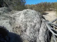
I'll show a few markers that might help someone. I call this the tictacktoe marker. 123degrees about 74.7 -77 feet, 28 varas (32") measured from the front, 28 varas (33") from the back. It has a tent shaped topline/ridgeline, that you sight down to the cross spot. 20210317_144009.jpg I've been semi working this place , since it's family land for about 5 years. Everything kind of came together in one day, I did not think I would find this spot where all the larger markers on the hillside came together on one spot that made sense compass bearing wise. As well as one other major thing, that I will show later, which is a personal find that I've seen similar on many other places in my area, but it's subjective somewhat on how you look from it/thru it and couldn't quite figure it out exactly where it went until a few days ago, and then it all came together on one day in one spot.
 

Attachments

  • 20161023_124509 2.jpg
    20161023_124509 2.jpg
    2.3 MB · Views: 67
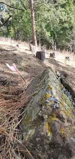
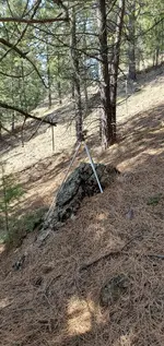
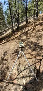
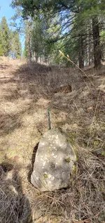
Here's the 111 degree marker. On the picture the compass is further away in, it goes to the right of screen at 111. The one with compass positioned over the flat rock marker is on the 321/141 line that it turns off from. So standing behind the further away marker in the shadows (which is a permanent outcrop), it turns off to left 30 degrees to the cross spot where every20210317_145037.jpg20210317_145256.jpgthing ends up..

The 111 degree marker may be an old rabbit head, can only make out the ear and maybe eye. Too old for good shaping. But it has a peak to measure form distance and degree. The peak is more important to look for. Oh, 39 varas to cross spot, 32 inch.
 

Last edited:
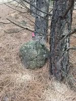
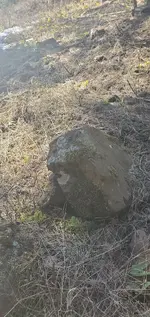
1st pic is 2 big boulders in a wash, lining at 232.5 degrees, you can see the pink string I pulled that goes up to the left at 202.5/22.5 (half quadrant)line, which continues all the way up the hillside past the crosss spot thru a couple good markers.View attachment 1912345View attachment 1912346 2nd pic is owl head/eagle head rendition from the side with lichen eyeball?, goes 135/315 degrees to cross spot (45 degree quadrant). More markers to come, this is a start.
 

Attachments

  • 20210317_135058.jpg
    20210317_135058.jpg
    2.5 MB · Views: 61
  • 20210313_154516.jpg
    20210313_154516.jpg
    1.9 MB · Views: 52
Last edited:
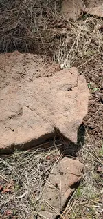
Here's a cut triangle on a marker near another one near the top of hill. The right straight edge goes right to the cross spot from about 60 feet away , no particular bearing I remember, I may check it again. It's the same sized cut triangle as my triangle markers near the cross spot. Look close it's inset on the rock , the points don;t point, it's the slightly hidden edge that points..View attachment 1912347 There's a slight crater near the corner that the edge goes thru. Kind of a partially notched out spot starting to show like the other triangle markers. redundancy I suppose. What you see here, you find over there. This theme actually comes into play again later.
 

Attachments

  • 20210317_134118.jpg
    20210317_134118.jpg
    2.2 MB · Views: 59
Last edited:
This was near the 330 page on Sandy1's post, I thought it would be symbolic to show the 330 line stuff. 330/150 is my favorite line where I am at. It's on 90% of the sites here. But I'm going to wait on that a bit because it has alot of things that target something that can be subjective on how you use it that has never been spoken of except by me occasionally and not well known but I have found repetitive at several places.... Also the markers on the main line at 202.5/22.5 have markers that I know , which I would generally only talk about in private. So , I will see what I feel about sharing as this goes. Hey, it could be a crapped out spot, so all my stuff could have no value for input... But yes or no, Sandy1's stuff is very good and I use alot of it and find it to be true.

What's on the 330/150 line and the 202.5/22.5 line are to me what makes this site very interesting. And I'm leaving those till last. The rest is just extra confirmation stuff which I already posted some of it. Also several of the markers on these two lines have "divots" or small craters on the center top of them to measure from. Interesting.
 

Last edited:
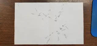
Here's a partial diagram, minus a few of the pointers and small hearts, diamonds, etc.20210323_103040.jpg
 

Strange, some of my photos aren't posting. Maybe I'll re-upload them later.
 

There was a type of peepsight on the side of the monument with eyes that lit up with a standing heart by it that gives you the same cross spot once you figure out specifically how to look thru it. When you walk out the line given from the monument (330 degrees) as well as the peepsight construction , you find a triangle shaped marker on the ground near the cross spot with markings on it that describes or imitates the peepsight setup and monument it's on that you just looked thru. That's what gave the spot away, the rest was confirming by compass. off the all the monuments in the area. The hardest thing was to figure the monument out, which nobody seems ever to have any applicable information on really, or is at least they are just very difficult to decipher correctly.

One thing I forgot , before I get too carried away digging for buried markers, I have a 98 inch coil on a Pulsestar2 PI detector that I need to fire up. The dirt from hole could cover up the spot if I'm wrong on dig spot part if it's a straight down dig and not tunneled (as well as screw up using the detector). Doesn't hurt to try it anyways. Hurts more to dig in the wrong spot. Probably head back next week, rains are coming.
 

Last edited:
20.8 inch cubit is very interesting. Will redo measurements more exact and see what comes up when I use huge PI coil.
 

20.8 inch cubit is very interesting. Will redo measurements more exact and see what comes up when I use huge PI coil.

Back up to the beginning, Q, if you will. Do you have any knowledge about who hid this cache, where they were from, where the loot originated, when it happened and why it is still buried? From your posts, it seems as if this all happened quite awhile ago - 100 years? 500? 1,000? 10,000? From the appearance of a number of surface items, it seems as if they wouldn't last the test of time, so they must be much more recent. Any ideas? Thanks.
 

Back up to the beginning, Q, if you will. Do you have any knowledge about who hid this cache, where they were from, where the loot originated, when it happened and why it is still buried? From your posts, it seems as if this all happened quite awhile ago - 100 years? 500? 1,000? 10,000? From the appearance of a number of surface items, it seems as if they wouldn't last the test of time, so they must be much more recent. Any ideas? Thanks.


No idea yet for sure, there is a very old trail that runs thru the property and it overlooks a small lake near the bottom end of a mountain range. When my relatives built the house 40 years ago or so, an old timer whose family basically homesteaded a place a ways further back in the mountain range, told him about the trail and said it was an ancient trail.
It's good place to bury something and come back and easily find again. Rock markers last a long time.
 

Here's a partial diagram, minus a few of the pointers and small hearts, diamonds, etc.View attachment 1912407
This is a very good example of things I find when entering a new area. One person long ago called it a clock map. I would like to know more about why this setup and who designed it. Jesuit is rumored to set up a lot of the mines and such here.
 

I don't know Rawhide, I have usually just lined up markers from marker to marker, This is really the first time I noticed lining up two markers and then taking off at 30 degrees from the line to a spot where everything on the hillside made sense going to the same spot. Although it's much similar to shooting thru triangles, and going 15 degrees off a triangle leg line. No detector hits today. But I'm expecting a tunneled spot there anyways, I'm not lucky enough for straight down digs.

I hate to even bring it up , but the measurements from markers to the spot all hit smaller than a pie plate sized spot on even numbers when I used a 20.8 inch cubit. 20.8 is an old long royal cubit, also was found on stonehenge and some other ancient structures. I suppose a group that has info that has been passed down from or some group that knew about old type measurements could have just used it. 60, 44,36,35,29,20,9, and the only oddball one was 5.5 cubits. There are still I think 3 or 4 other markers I didn't measure from yet. Not all are on my crude diagram. I don't think would use cubits in general, maybe once in a while on really old markers, and I have heard of people using a type of cubit measurement , although rarely. But there are a lot of different cubit measurements...so you could probably randomly find one that would fit it, even though it wasn't actually being used at a place. I do find it interesting and will probably keep it in the back of my mind.
 

Last edited:
HappyTrail , an all seeing eye basically just means to look. Can be out in front, can be looking towards something or a place near by to look from, or some gunsite type thing from near the eye. Or it can be gigantic eye covering a large area like a mine entrance, and the pupil with the iris being the near the opening. It's non specific. Yours looks more like a tilted egg, unless you are talking about the faint image thing in the middle. It's probably a marker that links with another somehow. It's got a line on it though, follow that maybe.
 

Top Member Reactions

Users who are viewing this thread

Back
Top