A GUIDE TO VAULT TREASURE HUNTING (Condensed)

Hi Sandy I'm new to the site. I just have a couple of questions for you if you don't mind.
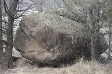
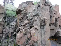
We are in a forest area in a creek that is filled with boulders. All the monuments along the creek point to a diamond shaped rock. See the photo. I would appreciate it if you would elaborate on the meaning of the diamond. Does it mean there's an opening or entrance under it or close to it? If it is where the diamond is would they have put it in the creek or beside the creek?
20190703_181755.jpg 20190714_102007.jpg
Thanks Running man

First photo is sideways, Diamond rock should be on top.
 

Last edited:
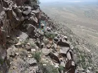
Sandy1 Post 1535 page 103----the more I look at this photo--the more I love it--I would love to see this photo along with one taken at the triangle of cactus --looking to what is the right in this photo--another words along what seems to me to be a sight line---as well as another photo--incorporating the U shaped marker --and then more to the right showing what seems to be up a slight slope --overall this is one of the more outstanding photos I have ever seem--it is on par with a stone diagram of the tunnel traps--showing how they attack an intruder--entering the tunnel. This is the kind of photo one blows up and makes a poster of to hang on the wall. Possibly simply moving further back or away--when taking this photo would allow more of the terrain / Spanish Markers on the right edge of the photo to show. This photo literally takes my breath away!
 

Backwoodsbob,--Post # 4488 Charles Kenworthy wrote an excellent book on traps--which should be understood--really understood before entering any tunnel. You seldom get a second chance if you slip up. I have seen the pivoting floor death trap that resets itself after eliminating the intruder in the tunnel. I also know of a man whom experienced this trap--the pivoting floor trap--and only the Purski knot on his safety line saved his life. He never saw the "Lightning Bolts" --even though he was using a spotlight--to carefully examine the tunnel walls---until after he was on the receiving end of this trap and his body was dangling over--the long fall down--the pit designed to break your legs--and leave you no escape!

The safest course of action is go for the small cache's that Sandy1 shows--if you go for the tunnels or mines--it is like playing cards with a professional gambler--whom can tell you each of the cards he deals you from the deck of cards. If you can not walk away--from a site--when you realize your in over your head--you have no business leaving the TV and going prospecting. The traps the Spanish placed are real--and very deadly--anyone whom tells me that a one or two hundred year old trap will not work--is probably a fool; of foolishly ignorant. For most of the elaborate traps--they will work just as well as 200 years ago as the same old gravity works now. As a man called Kelly told me --nothing is telling you it is time to call it a day--and give up and walk away from a site--as your crawling down a tunnel and in front of you is a solid block of rock blocking your path--and there is a mans leg and one boot sticking out from under the rock boulder.
 

Last edited:
1 (14).jpgThis one here was another of Sandy1 top shelf site the engineering is amazing.
 

Last edited:
View attachment 1740716This one here was another of Sandy1 top shelf site the engineering is amazing.

Think about being the folks who had to dig there first, then place gold there and cover it back up. You can imagine that someone lost their life at that spot. Loooonnnnng ways to the bottom.
 

Hi all, We've been really enjoying this thread. SO much stuff to pour through.
Thank you Sandy1. <3

We're still out here enjoying finding and photographing carvings.
Here's a big snake eating something, from the lavish site that's we've enjoyed photographing for years.
We find new stuff every time we go out.

SnakeEatRock.jpg
 

Hi all, We've been really enjoying this thread. SO much stuff to pour through.
Thank you Sandy1. <3

We're still out here enjoying finding and photographing carvings.
Here's a big snake eating something, from the lavish site that's we've enjoyed photographing for years.
We find new stuff every time we go out.

View attachment 1742018
Nice pic, cool of you to share it. 8-)
 

Here, Not sure if this will help any, I'll show you a rock with a drill hole on the side of it, and two separate places the rock goes to. The rock is an A frame from two angles, a heart another, depending on how far you are away, the angle you are looking at it, along with the position on the hill you are viewing it from. (it's a pyramid rock/"A" frame from both places you end up at) .

Anyways, the drill hole is on it because it is an important rock that is used to line up to other spots. As you will see both of these spots that you are lead to have a nice small heart lying next to them on the ground.

I can't confirm these are dig spots or next to dig spots, as I never spent alot of time on them. But it should be fairly to easily see that they were using them to align to spots.

My backpack stays in the same location to give you an orientation of where some of the photos were taken.

The first 2 photos are the rock with a hole on it's side viewed from two close up angles.

The 3rd photo is one of the spots it leads to, there is an owl or set of lobes part-way that you line up a few feet above the beer can. The beer can was nearby , I put it next the heart so my buddy I was with would see it when he came back down off the hill as he got side-tracked looking around for other stuff. I circled the drill hole rock up top, which is an A frame rock from that angle.


The 4rth photo is taken back by the drill hole rock again, and shows alignment thru a flat pentagon and large boulder that will have an X on it's backside (red line). The yellow line goes directly to a heart on the ground and it is where the topline pointer or ridgeline of the rock with the drill hole on it points (you may notice it is also a heart lobe) . Both lines end up pretty close to each other.

The 5th picture is taken from near the heart on the ground and you can see the drill hole rock sticking up in the background , as well as the heart on the ground and the large "X" shape on the back of the larger boulder.

The 6th picture is a close up of that heart.

Don't know if this will help any, these sites are all a little different but yet the same in many ways. Sometimes there are helper rocks, sometimes they are gone. I did not take auras here, perhaps I will sometime but I have no intention of digging there.

So this is how I "sign read" I read the markers that take shapes or have markings on them and line them up.
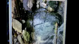
IMG_4962.JPGQuinoa here is my site with a couple of drill holes that I found still trying to lay it out.
 

Looks like a different type of drill hole than I was trying to show. Anyways, I just got back from a week long raft trip thru a very remote wilderness area, and I'm kind of speechless. I can correlate alot of stuff from sandy1's thread , plus some other stuff I have been talking about. Huge ancient mining corridor, I took a lot of pictures, I don't know what I want to say atm.
 

One thing I will say , and I've said before, and sandy1 has as well. They mapped mainly the river/water drainage's, not foot trails.. You look for the big boulders (like a small car sized) off to the side or on the rivers edge, sometimes even large ones that are shaped and in the river, and you go from there. But they aren't all shaped. Sometimes it's just a few huge boulders, and you have to sort out what was a landslide vs what was just put there.

But they marked places to leave the river for nearby mines as well as vaults. The mines were done in places that are on the underside of rock outcrops, and often look like a natural talus slope below them. They were following mineralization that often occurred on the low side of outcrops. I can't be much more specific, but it's very basic. Most rapids you come to are fault zones and have visible old mining activity by them. Very difficult to distinguish between what is just natural and what is very old. I saw some stuff that crossed the borders of what I expected.
 

So it was about an 80 mile raft trip, mostly thru a roadless wilderness area. I saw more mines and vault locations than I can remember, I should have had my camera out more, but I did manage to get some good shots.

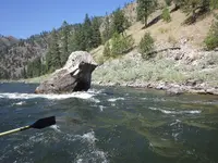
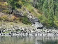
Here is a huge sunlit duck monument right in the water just off the shoreline, probably a carved over beak, may have been an eagle at one time. I looked up some of these spots on google earth when I got back home for bearings and such. This had a huge boulder just up hill on the shore from it at 330 degrees, about 50 varas away. There is a spot the duck is kind of looking at halfway up to it at about 25 varas, it's right near the top of the talus rocks in the photo.RIMG0065.JPG
 

Here's a couple huge marker boulders , the top one has heart cut on to it, I would guess it's a spanish mine a little ways uphill from it, probably at 225 degrees. View attachment 1745112

There was a large X made into another boulder on the waters edge just to the right and out of the picture. Next to the X you could barely make out in big 3 foot cut letters O R O, but only the first O showed up well in my other pics.

Incidently on the drive to the put-in I saw several large natural looking X's that were on huge slabbed boulders (like 100+ ton) that had flat face facing the water with an "X". Up behind each you see very old taling slides somewhere on the hillside along with square notches, shaft signs, shaped rocks , etc...
 

Attachments

  • 20190815_112009.jpg
    20190815_112009.jpg
    1.5 MB · Views: 93
Last edited:
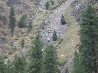
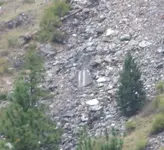
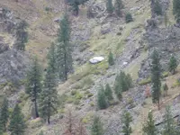
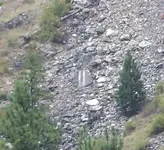
Zoom this picture up , dead center is a huge boulder with two parallel vertical white lines on it, this is another form of the "shaft" sign that Sandy1 speaks of so much. It can be done with two parallel cut rocks with a gap in between them, Notice the rock shape along with the position of the lines looks the same as many shaft signs, just no airspace (pointed side and flat topeed side with soemthing represented a gap or shaft). I saw a much larger ancient version of this (two parallel lines, but I didn't have camera out, you could see it from more than a mile away, and there was a huge 200 foot ancient head next to it with eyes that were made from small caves cut into the cliff. This is the mine shaft symbol, but used for other things as well, probably just really means tunnel,vein, or "cut" into the earth. Anyways its used on both mines and vaults.

View attachment 1745116View attachment 1745117
 

Attachments

  • RIMG9992.JPG
    RIMG9992.JPG
    1.2 MB · Views: 71
  • RIMG9992 crop.jpg
    RIMG9992 crop.jpg
    180.7 KB · Views: 67
Last edited:
So the talus slope that the boulder with 2 white lines is in is an old mine tailing wash. Looks pretty natural if you don't know what the markers look like. You can sometimes find the covered mine entrance from monuments across the river, there will be a peepsite type thing. I didn't try looking for it, we were on a schedule , guided trip.. but I have seen this before in other areas.
 

I have quite a bit more, going to stir some interest back in this thread.
 

Excellent photos and very good explanation of what to look for out in the field Q keep them coming very interesting country you were exploring thru.
 

Last edited:
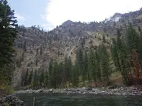
One canyon off to the left of the shaft sign rock ( far left middle side of next pic) was this gigantic flat rock laid out in the middle of the talus slope. I suppose this could mean to look for the mining signs, but I have seen smaller versions of this flat rock on cache sites. It could mean there is a large vault somewhere nearby here, possibly from stuff from the mines, probably the ones you hear about that stuff is stacked like cord wood. The photo is taken from a natural hotsprings on other side of river, geothermal areas are good for minerals, metals and they extend out thru the area. Anyways, it is way out of place and very visible to catch your eye.
RIMG9988.JPGRIMG9984.JPG

This area is off limits to mining, even gold panning, so I can post whatever I want and not worry about ever wanting to going back.
Note the big boulders on the rivers edge, but they aren't necessary with the visibility of the huge flat rock.
 

Last edited:
We camped at a what I thought was a vault/crypt location one night, I found a couple places that I thought were old vaults and there was a huge boulder at the landing. Did the bearings and distances work out to the spots I saw when I checked them google earth? Is there something to all this mathematically? It will take me a bit to post it all , but the results will be a bit surprising, although maybe nothing really that new to some.
 

Last edited:
To me this means something else. The meaning can be found on line,but it very hard to find. But the shaft sign sounds good to me. Looking forward to seeing more.RIMG9992 crop.jpg
 

Top Member Reactions

Users who are viewing this thread

  • Back
    Top