1715 fleet pop quiz

Ive only lived in Florida for 3 years. I live across the street from Pepper park. Most of the pictures Ive seen of the Cabin wreck show my house. Although I dont have the fever as bad as you guys I just invested in a whites Pi to play around on the beaches with and was considering a Hookah syatem after I complete my dive course in the fall. What I clearly need to learn is the leagalities pertaining to the leases that some off you have on spots. Is there a webste that lists all the leased and licensed areas including the Gps coordinates?
 

Ive only lived in Florida for 3 years. I live across the street from Pepper park. Most of the pictures Ive seen of the Cabin wreck show my house. Although I dont have the fever as bad as you guys I just invested in a whites Pi to play around on the beaches with and was considering a Hookah syatem after I complete my dive course in the fall. What I clearly need to learn is the leagalities pertaining to the leases that some off you have on spots. Is there a webste that lists all the leased and licensed areas including the Gps coordinates?
If you live near pepper park, the pictures you have seen are no where the cabin wreck. The cabin wreck balast pile is out in front of the the 3rd house with the blue roof just south of sebastian inlet in 12 feet of water. I hate to bust your bubble, but the pictures that you saw of your house are nowhere near the cabin wreck. Who ever showed them to you, or told you the location lied.
It is not the cabin wreck, but it is another 1715 fleet wreck. Do some research yourself, and you will figure it out.
Good luck.
I believe its called the Orca de Lima. I had asumed it was also called the cabin wreck and I am mistaken. Thats not what my question is about. Id like to learn more about the regulations asociated with leases, beaches, high tide lines, state archeological protected sites Etc. etc. etc. Is all this stuff top secret or is there a single source where I can learn how to not step on anybodys toes.
 

The State of Florida believes that wreck to be the Urca de Lima. They also believe it is a violation of Florida code to look for shipwrecks and shipwreck material in their territorial waters without an exploration permit.

In the State of Florida the beach from mean low tide to the dune line is public land and searchable with a metal detector. With some exceptions, check local ordinances...
 

Barrell:
Urca de Lima. It is a dedicated underwater park site in Florida and you can not metal detect in the water near shore there. Above the mean high-water mark you can detect. Don't ask where that mark is... it is a fuzzy definition. There are commercial interests that might challenge you in other locations, claiming you are trespassing if you detect in the surf. You're on your own. Be aware there is a certain amount of dis-information spread around from time to time regarding this issue. Also, there are restrictions metal detecting in more shoreline based parks throughout the state, and Federal parks generally prohibit metal detecting period. There are other previously explored sites adjoining the Urca de Lima, and some of the old Fisher lease area extends to the north side of the north jetty at Ft. Pierce Inlet.

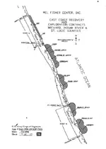
I have attached a lease map from the Corp. of Engineers which they use as an exhibit in their permitting for salvors. Note that this illustration only shows the Fisher leases as recorded for posterity, per assumption by Queens Jewelry Co. There is at least one other similar area controlled by the HRD company, if they are still in business: I am only vaguely aware of the extents. Furthermore, there are more controlling interests running northward from the boundary outlines on the north side of this map, allegedly stretching to Cocoa Beach, but, once again, I am not up on the boundary limits here, but they do begin at the mean high-water mark on shore.

As for finding a convenient official map... good luck! I've never found one hosted by the state, and, I don't think they are officially interested in promoting such a thing. It would become a litigation issue, no doubt, but you would have to read all the history regarding developments surrounding the treasure salvage business in Florida before you would get the big picture. It goes back a long ways, for many years, and there's nobody employed by the DHR in Tallahassee who has complete tenure with the state stretching back to the first Internal Improvement Trust Fund agreements with Steadman Parker/Kip Wagner era.

As for stepping on toes, well we are not ballerinas here and routinely make a habit out of stomping on each other's little tootsies!
Image3.jpg
 

So much of successful treasure hunting is research, in various forms. If you want to do the research it's not too hard to find the information. - Cheers

Florida Division of Historical Resources
Bureau of Archaeological Research
Exploration & Recovery Permits and Contracts, July 2011

View attachment FL State Permits Web.bmp
 

Last edited:
Where is it? I'd love to see if it is un-redacted.

Barrell: BTW, you might try Gary Drayton's book(s)
New Sovereign book!
 

Thank You Sign em ups and Au Dreamers for taking the time to to explain. You seem to be telling me there is some debate to the boundries and rules. Not what I wanted to here but Il try to always be on the safe side.
 

Ship: Nuestra Senora del Carmen, San Miguel and San Antonio. It

was the former British ship of the line Hampton Court, armed wtih

72 guns. 713 tons. Master Don Justo de Cevallos. A ship the

Indies was armed with 50 Cannons.

Merchant ship: Our Lady of the Rosary and St. Francis Xavier.

312 tons. Its captain was the son of Antonio de Echevers. Don

Manuel Alvarez Maestre.

Ship: Nuestra Senora de la Concepcion San Jose and San

Francisco Javier. 275 tons. Don Diego P ablo Maestre Soliac.

Ship: Nuestra Senora de la Popa.

Ship: San Miguel, alias El Ciervo. Built in Vizcaya. Antonio

Property Echevers. Maestre Alonso de Figueroa. 22 guns (18 to 4

and 4 to 2 Pounds).

Ivan I’m sorry but I would have to disagree with you on this one I have taken my sweet time to research all the names of the vessels, religious names, nicknames and aka’s and I have never seen “El Ciervo” called San Miguel. Plus Echeverz patron saint was Nuestra Senora del Carmen not San Miguel


itmaiden
 

Last edited:
HRD is still in business and has the site lease between corrigans and rio mar.Our site encompasses corrigans and rio mar and goes all the way out to the 3 mile limit.Pirates not welcome.
 

I think John meant to say that the HRD site encompasses the outside, deeper areas of Corrigans and Rio Mar...and the 5 mile nearshore stretch in between. See updated map. TomHRD lease.jpg
 

You know, Tommy took the Gordy combine there early on many years ago, but they did not even inspect the wreckage there. This whole HRD deal has been a great mystery to me for a number of years. Can anybody tell me why it is not being seriously worked?
 

Terry, part of it is a money issue. I think the other part is mismanagement.

There was a very good mag survey done on that site by Jim Whitaker in the late 1990's and many of those anomalies have never been verified. Then I think Greg Bounds did some additional magging of the site.

It is an interesting site with lots of potential, especially if you look at what areas it encompasses.

There has to be money there... found money that is.
 

I have read through this thread, impressed with the knowledge of those who offered their wisdom, however, I am curious about something that seems to go begging to be answered. In some old literature of where to find the 1715 treasure, there are mention of finding coins on the Aquarina and old Chuck's Steak House beach. They say coins have been found on these beaches. My question: other than coins, has there ever been any other items that might indicate that something actually wrecked in this area? I know the Polly-L was working off Melbourne Beach for a while and someone (I don't know who) was working across from the fire station close to Aquarina some time ago. I never heard anything about what was found, if anything. Just wondering?????
 

Top Member Reactions

Users who are viewing this thread

Latest Discussions

Back
Top