1715 fleet pop quiz

The water side of the area that you can metal detect is called the Mean Low water line. Not Mean High tide, there is no mean high mark-other than the point where the tides go to, but that is just called high tide line. This, Mean Low, is the line that tides run off of, and how depths on charts are written from. When the chart says 8', it is 8' deep at Mean Low. All Nav charts. Like when the high, high tide says 2.5 on the tide chart, it is 2.5 feet above that Mean Low line. Usually in Florida our low tides dont go below the Mean Low mark. It has to be a negative low to be below that point-( -5 is 1/2 foot below Mean Low). For the law it means out to the water, you cant be in the water detecting..And for the salvors, you cannot dredge away the beach. You could go right up to it, but cannot take away the dry sand. Pretty cut and dried if you ask me. Like at high, high tide, you cannot be knee deep in the water, just because the tide is high. Stay out of the water.
 

Last edited:
Reviving the thread on the eve of the 298th anniversary of that fateful night...

#1. Is it worth to keep hunting the 1715 wrecks and why?
Yes. The people who died should not be forgotten. Their artifacts are all that's left, historically speaking.

#2.How many vessels do you think were traveling with the fleet's? Explain why.
12. Pretty clear in the documentation. Ubilla + Echeverz + Grifon

#3. Which vessels do you think have been found and what is the known area of the wreck location?
Urca de Lima for sure @ the protected area. The rest are iffy.

#4. Which of the missing wrecks would you try to find and why?
This is my favorite question. The one wreck I wish could be identified is Echeverz's flagship Carmen. Why? Because (from what I can ascertain) it used to be England's Hampton Court, which had a RICH history of mega battles since it was built 37 years earlier. The stories that ship could tell are endless. Maybe it is the Rio Mar wreck, maybe not. Would love to know.
 

Last edited:
why were so many of Echerez's vessels named "san miguel " ? note the "habit" echerez had of using it -- #1 senor san miguel a NAO class vessel (the tabacco hauler vessel ) he bought that stayed in havana loading tabbaco --- treasure galleon class vessel (nao type--but beefed up) san miguel #2 (former hampton court)--#3 the dutch prize (a galera type or small frigate type vessel )--"san miguel" and what of "san miguel de excelsis" ? aka the english prize --one of the 3 taken by Echerxez pataches as he sat in porta bello. --- so the dutch prize is the * frigate "san miguel" -- the english prize is "san miguel de excelsis" and the french prize is ?-------- do you note a pattern here -- taken or bought prizes called "san miguel"

the frigate that left the fleet --must be the french prize * since it was reported that "the frigate san miguel " left the fleet and the only other frigate class vessel was the dutch prize / Olandesa which is reported as wrecked near the bulk of the fleet as it was used as a shelter by Echeverz during salvage. thus it was with the bulk of the fleet .

Quick answer - his elder brother was the Marquis of San Miguel de Aguayo in Spain near where they grew up. The brother died young-ish. I'm still researching Echeverz (too bad I don't speak Spanish - would be so much easier!), but I get the sense that he hero-worshiped his big brother. They were noblemen.
 

Last edited:
Sebastian Sam,

Where do you think every one has gone wrong? Anyone else other than Sam please feel free to answer this question....

The above Quote was written by Chagy on Jan. 05, 2009. Some folks may have tried to answer this but since I have not read every post, I have not seen it and am sorry! While I have long known about the 1715 Fleet and other shipwrecks along Florida's Treasure Coast, I have not spent a lot of time researching any of these. However, having worked for the National Weather Service for nearly 33 years, I do know hurricanes, what they are capable of and I know the Treasure Coast's geography. I believe that where some folks have gone wrong in trying to find some of the shipwrecks, is that they have been looking in the wrong places. In that I mean, that the strip of land along the Treasure Coast has very thin sections and wider sections and some of these sections are lower or higher than other sections. Then there is the area of what I call an Intercoastal Waterway (I can't rmember what it is actually referred to) inside of 9or West of) this strip of land and then another coastline. While some of the ships that went down in the Treasure Fleet may have went down at sea in the deep, others are known to have ran aground and broke up along the strip of land called the Treasure Coast, I believe that some of these ships due to their' construction, weight and amount of cargo they carried, were blown or pushed over this somewhat narrow strip of land and into what I call the Intercoastal Waterway. I theorize this due to the shear power of the winds of the hurricane but also due to the reef being so close to shore which would cause a much larger storm surge to be created and one which could easily lift a ship from it's original shipwreck location and push it up and over the strip of land that is called the Treasure Coast and into the Intercaostal Waterway. Therefore, I believe that in this Intercoastal Waterway and along it's inner shore, is where some of the missing 1715 Fleet ships ended up! This scenario is very similar to what happened to the Atocha when she sunk, then was lifted off the rocks and pushed and blown to the present site of the Atocha Treasure Trail. Whether it was the original hurricane that caused the ships to run aground on the Treasure Coast or the storm that hit two days later that may have done this, it does not matter. It matters that this scenario is a good possibility and one that those looking for the missing 1715 Treasure Fleet ships, should consider!

As I understand it, this area is off-limts to treasure hunting and this is just one more reason why the Laws in Florida need to be changed!


Frank
 

Quick answer - his elder brother was the Marquis of San Miguel de Aguayo in Spain near where they grew up. The brother died young-ish. I'm still researching Echeverz (too bad I don't speak Spanish - would be so much easier!), but I get the sense that he hero-worshiped his big brother. They were noblemen.

Actually, Don Antonio, the 1715 Fleet General, didn’t have any connection to the valley of Aguayo, Spain, where the villages of San Miguel, Santa Olalla, and Santa Maria were located. His brother, Agustin, only received the title, “Marques de San Miguel de Aguayo,” when he helped the province out of a major debt and purchased land. That was around 1682, many years after Don Antonio left for New Spain. Another fact was that San Miguel de Aguayo, in Cantabria, was nearly 200 miles from his home in Pamplona, a far distance back in those days.

Antonio likely did not use the name, “San Miguel,” because of his brother. Document sources hint: “enfrentamiento con su hermano,” a firm reason why Antonio left for the Americas since he did not see eye to eye with his big brother.

So why did Antonio have a personal devotion to St. Michael? No association to his day of birth since he was born in July and September 29[SUP]th[/SUP] is the Feast Day for San Miguel. I’m guessing because Saint Michael is the Archangel of battle and the defender of Heaven, many Spanish officers, besides Antonio, showed great love for this saint.

I’ll buzz you, Tammy, when chaos slows down over here.

Laura :)
 

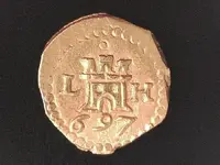
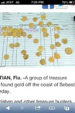
Obviously we didn't find all of this; however, it answers that question of whether or not there is still stuff left.

Just wait until you see what we are going to find at Douglas. I promise it will be big.

-Captain Eric Schmitt Booty Salvage Research and Recovery.
 

Attachments

  • image-316765877.jpg
    image-316765877.jpg
    35.3 KB · Views: 121
  • image-2288849492.jpg
    image-2288849492.jpg
    68.4 KB · Views: 124
  • image-3629478787.jpg
    image-3629478787.jpg
    63 KB · Views: 110
  • image-1786747023.jpg
    image-1786747023.jpg
    61 KB · Views: 138
  • image-3697240396.jpg
    image-3697240396.jpg
    63.5 KB · Views: 134
  • image-1920554937.jpg
    image-1920554937.jpg
    73.3 KB · Views: 114
  • image-3021168821.jpg
    image-3021168821.jpg
    79 KB · Views: 118
there is much more to be found * according to the records after the 1715 fleet wrecked more "treasure" was recovered during the salvage "recovery" than was on the official manifest to begin with --the king was quite pissed off by this as it "proved" that massive smuggling was occurring --
 

"I believe that some of these ships due to their' construction, weight and amount of cargo they carried, were blown or pushed over this somewhat narrow strip of land and into what I call the Intercoastal Waterway."

Frank, I think you are correct in your theory. One great example is the Regala, also called the sandy point wreck. This was the Capitana of the fleet and should have the most treasure but the trail ends at the beach and very little has been found. Some of the pirates I know have found artifacts on the intracoastal side.

Is there any chance that someone could get a permit to search these areas? If not, then the Treasure Hunters and Metal Detectorists and other with interests, need to get together and create petitions, get them signed by as many folks as possible and then petition the State of Florida to change the Laws. There are millions upon millions if not billions of dollars worth of treasures that may never again see the light of day, may never be viewed and enjoyed by thousands and possibly millions of folks in a museum type of environment and may never benefit individuals or corporations and the State of Florida itself, if something is not done to change the Laws!


Frank
 

Last edited:
The "sandy point wreck" should have a lot of the Queens jewels since it was the Capitana of the fleet.

I think this is part of the "Pelican Bay Marine Sanctuary" so metal detecting is not allowed.
 

Last edited:
the queens jewels are recorded as being loaded upon the Capiitiana of the fleet * but remember this there were really 2 fleets ( Ubilla and Echeverz each had their own fleets )==(note which fleet the emeralds were loaded on * due to being mined in Munzo, Columbia )--however Ubilla being senior in rank was the combined fleets commander *-- so there were really 4 "major treasure vessels * --each fleet had 2 royal ships, which were the lead and rear "heavily manned and armed " nao sized vessels of the fleet normally.

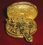
can't metal detect emeralds unless their mounted in gold --but you can see lil green stones with your eyes or by sand sifting--they also glow on dark highly overcast nights when put under a "black light source".:laughing7:

some stashes found over the dunes might be from stolen or hidden loot -- there are many stories of common Spanish peon type sailors taking loot and hiding it in hopes of being able to somehow return and claim it --(thus setting themselves up for life) --a few foolish ones tried to steal items and run to St Augustine and escape by boat to America before the word of the 1715 fleets wrecking got out --it did not work , they got caught as they arrived in St Augustine and were hung
 

Last edited:
I am not sure whether the theory that some of the ships or wreckage may have been blown over or washed over the dunes into the river but it certainly seems plausible... any supporting archival documentation available with regards to this? I do recall reading somewhere that some longboats were loaded with treasure aboard and were taken out into the river to hide the treasure from pirates, etc.

I know that many amazing finds have been made over the years along these "shores"...
 

Attachments

  • 1715KangxiRD1.jpg
    1715KangxiRD1.jpg
    1.1 MB · Views: 134
  • 1715KangxiRD2.jpg
    1715KangxiRD2.jpg
    1.2 MB · Views: 131
  • 1715KangxiRD4.jpg
    1715KangxiRD4.jpg
    838.9 KB · Views: 135
  • 1715KangxiRD9.jpg
    1715KangxiRD9.jpg
    989.7 KB · Views: 125
I know this is an old thread but did anyone consider where the beach was in 1715? Was it 1/2 mile out into the ocean as it is now or was it 1/2 mile inland? that could make a big difference. Fl beaches are always changing.....
 

They already had 1500 people on site..Seems like more then enough to pick up the pieces after the storm..

1,500 people survived? From 9 ships? Really? how big do you think the ships were? The few that survived would soon be overtaken with heat, thirst, hunger and insects. It was all scrub brush and you would be lucky to make it a few miles each day walking. The Indians, snakes and bears would make it hard to survive as well. 100* heat and 95% humidity in July, Aug, Sept. They were lucky if 100 made it.
 

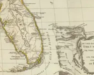
There are plenty of maps from that timeframe, or close to it.

1794:

ffwNqzj.jpg
 

thanks for waking this old thread up,lots of good reading stuff here:)
 

I'm thinking the best shot at some of that 1715 treasure is going after the Emeralds....Beach sand sifting :).... One thing for sure IF they ever made it to the beach,their still there .As no M.D. made can detect them . 003.JPG
 

Last edited:
I know this is an old thread but did anyone consider where the beach was in 1715? Was it 1/2 mile out into the ocean as it is now or was it 1/2 mile inland? that could make a big difference. Fl beaches are always changing.....

As for the Sandy Point wreckages the island is relatively wide today, but who knows what the shape was 300yrs ago. Here is a Goole Earth crest shot
6b0d5d01-96c8-4c90-83f9-b80cffa93a32
 

Last edited:
As for the Sandy Point wreckages the island is relatively wide today, but who knows what the shape was 300yrs ago. Here is a Goole Earth screen shot
6b0d5d01-96c8-4c90-83f9-b80cffa93a32

Well, I tried to include a screen shot but did not work, but you know what I mean
 

Top Member Reactions

Users who are viewing this thread

Latest Discussions

Back
Top