LDM why you cant get it !

Re: LDM why you can't get it !

I just would add that the '6 pounder cannon' looks like it could be a picnic table. Satellite images are just not good enough for absolute conclusions; it is why you hear of accidental bombings of weddings etc by our military when mis-identifications are made, and that by trained experts. Sorry Jack but I remain respectfully un-convinced by satellite images, it takes some 'boots on the ground' work to make solid conclusions.

No offense intended amigo, just don't find satellite OR aerial photographs to be the best evidence we can rely on.
Oroblanco

:coffee2: :coffee: :coffee2:
 

Re: LDM why you can't get it !

Additionally, google earth has an upgrade option

I got that upgrade - when you buy it, in the "agreement", it says that it does not give better resolution. (where you clicked "I accept). It did/does
give you better capabilities like importing data, higher resolution FOR PRINTING (for exporting, not for seeing), and, if you read Google Earths own reports, you will find that the Google plus resolutions (for looking) are the exact same as the non paying google earth. Other options we got with Google earth plus is GPS coordinates.

Google Earth Pro is now available, and the upgrade that was available a couple of years ago is no longer even available.

As per the Google Earth site: (questions and answers): (quote:)

Do I get better resolution imagery with Google Earth Pro?if i buy it
the full version i have the property to see and have good resolution?i
have install the trial version of google erth pro!and i dont have good
resolution in the area i want to see!if i buy the google earth pro i
have good resolution in this areas?

No, image resolution is the same for all versions, it's features and
license that differs. Compare the descriptions of the different
versions to see the extra features etc. (Unquote)


Point here, being, that we can see exactly what you see - its the interpretation that differs.

Beth
 

Re: LDM why you can't get it !

the 30mm cannon is in fact a very complex UPJ


unidentified piece of junk ....LOL
 

Re: LDM why you can't get it !

glad you clarified that Blindbowman,

around here "UPJ" means University of Pittsburg at Johnstown.

I threw that cannon bit in there to soften things up, but still have not ruled it out, there is a smaller cannon near here (PA) for a lawn ornament.

================================================
Beth & Roy, I'm with you all the way on "Boots on the Ground", satellite imagery has its limits.

Anyway:

I started this thread in all Seriousness of the information, theory etc that I offer, nothing has changed:

'B' rock at the entrance does not look natural to me. I see course desert composition (soil), not fine sand that will change its shape hourly on a good day. The soil on the very top edge is rounded over, like having poured pancake batter. That tells me the soil is backing up at this edge, going down hill from its weight, due to inclement weather thru the years. The soil particles are heavy compared to fine sand particles, once you place a large quantity, it's not going anywhere, excluding the middle of an arroyo.
 

Re: LDM why you can't get it !

Jack H wrote
I started this thread in all Seriousness of the information, theory etc that I offer, nothing has changed:

Agreed amigo. I know it may appear that we are trying to 'tear down' your theory here which is NOT the intention, and for anyone who thinks that, I would point out that great discoveries HAVE been made by studying satellite photos, such as the legendary lost city of Ubar for one example. Of course in that case (as with pretty much all) the discovery was not verified and proven until the 'boots on the ground' confirmed it. So it is absolutely POSSIBLE that you have well have something there Jack, just that some of us wish to see more research into the matter - including field work which may will take some red tape no doubt.

Good luck and good hunting Jack and everyone, I hope you find the treasures that you seek.
Oroblanco

:coffee2: :coffee: :coffee2:
 

Re: LDM why you can't get it !

Gentlemen, Ladies,

Hopefully, I have corrected errors of my ways on previous posts of Es Carbadia vs El Sombrero, as well as the first of 4 Peaks reference.

This thread has not stopped, but has taken a brief diversion with my first post followed by a few more on another thread:
Re: “If someone is surreptitiously working the Lost Dutchman Mine" #77 Posted Mar 07, 2011, 08:40:45 AM: (http://forum.treasurenet.com/index.php/topic,297455.0.html)

I will soon be back on this thread with my analogies of other Maps from the "Library" linking the Red Mountain area.......J
 

Re: LDM why you can't get it !

JackH said:
Gentlemen, Ladies,

Hopefully, I have corrected errors of my ways on previous posts of Es Carbadia vs El Sombrero, as well as the first of 4 Peaks reference.

This thread has not stopped, but has taken a brief diversion with my first post followed by a few more on another thread:
Re: “If someone is surreptitiously working the Lost Dutchman Mine" #77 Posted Mar 07, 2011, 08:40:45 AM: (http://forum.treasurenet.com/index.php/topic,297455.0.html)

I will soon be back on this thread with my analogies of other Maps from the "Library" linking the Red Mountain area.......J

should that read EL Cobollo vs EL Sombrero...?
 

Re: LDM why you can't get it !

Quote:
should that read EL Cobollo vs EL Sombrero...?

There is No doubt that the resources of the most Knowledgeable on this subject will find Descriptive/Questionable errors of my posts. And I applaud that.

In the beginning of this Quest, I looked at the general known information, but not to deep, there were 10s of thousands before me. But I asked myself, "What is being overlooked by most everyone following the same information ? That told me that there is too much information out there, since no one has been openly recognized as having found the LDM, comparable to the Bull Frog Mine ? From a book read several years ago which linked Death Valley Scotty & the Bull Frog Mine, silver mining and the economic devastation of the German economy which was based largely on silver, I am unable (time restraint) to locate the (Bull Frog) connection. But have included an excerpt of a complicated series of movements of German reaction and United States.

Quote:
Coinage Act of 1873 The decision of the German Empire to cease minting silver thaler coins in 1871 caused a drop in demand and downward pressure on the value of silver; this had a knock on effect in the USA, where much of the supply was then mined. As a result, Coinage Act of 1873 was introduced and this changed the United States policy with respect to silver. Before the Act, the United States had backed its currency with both gold and silver, and it minted both types of coins. The Act moved the United States to a 'de facto' gold standard, which meant it would no longer buy silver at a statutory price or convert silver from the public into silver coins (though it would still mint silver dollars for export in the form of Trade Dollars)[6]

The Act had the immediate effect of depressing silver prices. This hurt Western mining interests, who labeled the Act "The Crime of '73." Its effect was offset somewhat by the introduction of a silver trade dollar for use in the Orient, and by the discovery of new silver deposits at Virginia City, Nevada, resulting in new investment in mining activity.[7] But the coinage law also reduced the domestic money supply, which raised interest rates, thereby hurting farmers and anyone else who normally carried heavy debt loads. The resulting outcry raised serious questions about how long the new policy would last.[8] This perception of instability in United States monetary policy caused investors to shy away from long-term obligations, particularly long-term bonds. The problem was compounded by the railroad boom, which was in its later stages at the time.

In September 1873, the American economy entered a crisis. This followed a period of post- Civil War economic overexpansion that arose from the Northern railroad boom. It came at the end of a series of economic setbacks: the Black Friday panic of 1869, the Chicago fire of 1871, the outbreak of equine influenza in 1872, and demonetization of silver in 1873. (http://en.wikipedia.org/wiki/Panic_of_1873)

Note: wikipedia is much like this venue, anyone can start a page for displaying known information. Anyone can expound on that info. This info from wiki places the silver as a last reference, it should have been the first reference which most everything else was a reaction.
 

Re: LDM why you can't get it !

(Note) Dec 18.2012 Please remember the location of the Ancient Salt Channel Reference in Google image and move on to post # 195, pg 10. The 4 Peaks reference is in Error here, as well as other thoughts. (post # 110).

Gentlemen, Ladies,

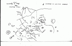
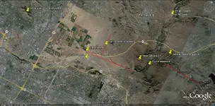
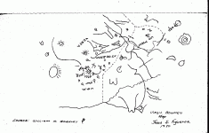
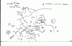
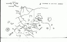
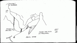
This is Map #10 from the Library. I am not trying to explain Virgil Bowman's Map. But I think you will see some similar landmarks corresponding with this Map.
The drawing looks as if it's of earlier origin (Spanish references). Most significant is the (MUCU) area. Today this looks like a mine (imagery). Someone out there has probably already compared this. All I am doing here is showing what I see within this Map referenced by the satellite imagery.

The Salt channel reference: http://www.gemland.com/hohokam.htm

If I (had to) analyze the upper area: left to right long uneven line (Salt), peak (outcrop right of Red Mountain), 3 uneven lines (terrain left of outcrop), uppermost peak (El Carbadia ?), line circling outcrop splitting El Carbadia ? (leading back to several peaks reference), 4 below several peaks reference is really (key) to single peak to the left which is Red Mountain again, apex over peak leading back to several peaks reference.

Additionally: the 3 uneven lines (3 Red Hills reference), bottom line (Caverna Con Casa).......J
 

Attachments

  • RED MOUNTAIN LIBRARY 10.gif
    RED MOUNTAIN LIBRARY 10.gif
    11.7 KB · Views: 1,617
  • RED MOUNTAIN MAP 10 aerial.jpg
    RED MOUNTAIN MAP 10 aerial.jpg
    320.5 KB · Views: 1,634
Last edited:
Re: LDM why you can't get it !

Jack---

This is one of the maps that I can't make heads or tails of.

I also thought that some things are shown twice, as though it's a combination of maps. Or some things are "blowups" of things within the main map.

A few things I think I recognize, are the "ORO," which appears on some of the other maps, near the southern entrance to the Supers. It would appear to be a landmark or carved sign, which is supposed to be there.

Another thing is the fried egg on the lower left, near the ORO. I'm thinking that's Superstition Peak. And near the bottom, just right of center, the narrow pinnacle with the side hump would appear to be Weaver's Needle.

If the line across the top is the Salt River, then the pointy peak could be the Four Peaks aligned. There is a thing that looks like a bird head, with it's mouth open just in front of that pointy peak, which could be what looks like a bird head, only with it's mouth closed, on the maps that show the Pit-Tunnel-Cave Casa configuration, and usually a needle in the foreground. If that's what these depict, then it appears to be a blowup of an area within the main map.

Other than that, it's very confusing. Maybe a few landmarks that could match up with actual geography there. And the many symbols and odd lines make it appear more confusing.

To me, right now, I would guess it's just another map of Mexican mines, except the possibility of the Four Peaks group of representation that I mentioned is very interesting because this setup is indicated in some of the LDM legands.

Maybe you can make more sense of it than I can.

:icon_scratch:
 

Re: LDM why you can't get it !

Mrs. O---

That doesn't do a thing for me....

The only difference is that I can't read the writing that I couldn't read anyway.

But none of that map seems to align with anything at all, that way.

Do you recognize anything?

:icon_scratch:
 

Re: LDM why you can't get it !

Well, now that I look at it some more---

The "W" at the top could be the Four Peaks aligned, because they do show as one mountain with two peaks, due to the offset of the front one.

And the dotted trail line looks familiar where it makes a loop at the top right.

But it looks like the tallest needle, at the bottom would have to be Miner's Needle, and Weaver's Needle is the smaller one above it.

Hmmmmm. :icon_scratch:


Maybe you're right about that.
 

Re: LDM why you can't get it !

Although it looks like a map, it is my firm belief that this is nothing more than a doodle pad of ideas or instructions to a second person through the use of penciled graphics. The location of different "explanations" on the page may or may not indicate the true position in relation to other information already drawn on said document.

It appears to me that the true source of this document along with the participants at the time of the drawing is most crucial to the relevancy of any information portrayed on it.

It's just my opinion so don't take it too seriously.

Enjoying the 'thread/expression of new ideas' on the subject.

Ken 'dustcap' Chichester
 

Re: LDM why you can't get it !

Quote "dustcap":
Although it looks like a map, it is my firm belief that this is nothing more than a doodle pad of ideas or instructions to a second person through the use of penciled graphics. The location of different "explanations" on the page may or may not indicate the true position in relation to other information already drawn on said document.

It appears to me that the true source of this document along with the participants at the time of the drawing is most crucial to the relevancy of any information portrayed on it.
===================================================================================================

Exactly Ken,

I see 4 different hand writings on this page:

1) map maker
2)BARKLEY
3)BOWMEN
4)Figueroa

So how many of these names/persons have added to the map ?

Quote EE THr:
(I also thought that some things are shown twice, as though it's a combination of maps. Or some things are "blowups" of things within the main map.)

(Exactly EE Thr.......J)


The Author is of steady hand (map maker by experience/profession). Added info not as steady.


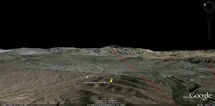
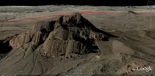
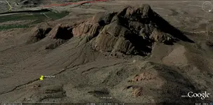
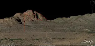
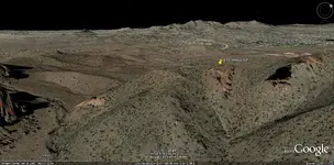
Map #10 'Spanish way' (VEQSA) ref: the Peak is Red Mountain with the interior lines showing the (character) of the Mountain, As in the photo. Photo showing outcrop north of Ft Mc Dowell Rd. You will need your own google earth control to see the similarity of this outcrop, as well as the (character) of Red Mountain. Photos taken looking W SW and comparable to the drawn image from a nearby high point. Photo showing 4 Peaks in 180 deg relationship to other photos.
 

Attachments

  • RED MOUNTAIN LIBRARY 10.gif
    RED MOUNTAIN LIBRARY 10.gif
    11.7 KB · Views: 1,395
  • RED MOUNTAIN MAP 10 VEDSA-4PEAKS.jpg
    RED MOUNTAIN MAP 10 VEDSA-4PEAKS.jpg
    169.9 KB · Views: 1,403
  • RED MOUNTAIN LIBRARY 10.gif
    RED MOUNTAIN LIBRARY 10.gif
    11.7 KB · Views: 1,374
  • RED MOUNTAIN MAP 10 VEDSA.jpg
    RED MOUNTAIN MAP 10 VEDSA.jpg
    269.8 KB · Views: 1,439
  • RED MOUNTAIN MAP 10 VEDSA OUTCROP.jpg
    RED MOUNTAIN MAP 10 VEDSA OUTCROP.jpg
    281.4 KB · Views: 1,436
Re: LDM why you can't get it !

Gentlemen, Ladies,

I am not here to improve my post count. Only those who are truly interested in my work will see there is more than my imagination at their finger tips. They will take the time to investigate by verifying my findings, by using the visual tools available to them.

It is difficult to find a visual angle to see the Map I choose for my Theory, on each of my Map posts. Use the tools, and you will find multiple visuals to pull in (All) my offerings. Otherwise you are wasting your time and mine trying to explain what you can't see without trying to investigate my findings.

That being said,

Map #60:

(2,500 Feet)
EL SOMBRERO (satellite imagery measures 2700+ Red Mountain) I have no informaton on any other area other than what leads to or includes Red Mountain.

As best with the tools I have available, I have outlined Red Mountain 3 outlines to follow the drawing. It gets better if you do it yourself, you will not need the red lines.

The thick black line above Caverna San Casa, is a Waterfall caused by Heavy Rain, which Matches the filled arroyo at the bottom. Look back to previous post pics to see the pattern of the water onto the floor bottom cascading over one of the filled caves.

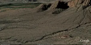
Left of (TUNEL) is the rock face across from the Casa. Right of (TUNEL) is the Funnel. Above the Funnel is (NOT) Es Carbadia. Quote: "There is a thing that looks like a bird head !" (Thank You EE THr) It is a Birds head (in, not sitting on) the rock at the top of the crest. The last photo shows a bird facing right to left, wings outstretched. Using tools you will see the shape of the head at several angles. The shallow peak behind the bird head is visible using the tools.

The NEEDLE ? Is an outcrop on top of a crest on this ridge line.......J
 

Attachments

  • RED MOUNTAIN MAP 60.gif
    RED MOUNTAIN MAP 60.gif
    10.4 KB · Views: 1,441
  • RED MOUNTAIN MAP 60.jpg
    RED MOUNTAIN MAP 60.jpg
    200.5 KB · Views: 1,382
  • RED MOUNTAIN MAP 60 IMG BIRD.jpg
    RED MOUNTAIN MAP 60 IMG BIRD.jpg
    276.2 KB · Views: 1,385
Re: LDM why you can't get it !

Gentlemen, Ladies,

I am not here to improve my post count


Well........................
That's kind of what you are proposing, isn't it? You are trying to prove that it is somewhere where nobody can go, so cannot be proved or disproved by "boots on the ground".

So - what's the point?

Beth
 

Re: LDM why you can't get it !

Map #60 presentation pretty much explains itself in detail, with nothing left out !

But, is anyone out there still looking for a 'Heart' ?.......J
 

Attachments

  • RED MOUNTAIN HEART 1.jpg
    RED MOUNTAIN HEART 1.jpg
    280.7 KB · Views: 1,321
Re: LDM why you can't get it !

Jack,

Most of the people still working with the Stone Maps, I assume, have already found their hearts, in fact dozens of them have been found. For me, the question is where is the rest of the map in relation to their heart, as it is laid out on the Stone Maps.

If they are indeed maps, it should be obvious where the other markings are. Running lines from various points on the Stone Maps and seeing where they cross through other landmarks, and then doing the same thing on a topographic should prove out your theory. They either match, or they don't.

So far, the only one who has ever done that with any degree of accuracy, is me. :) Everyone else has to move the markings around, usually to a large extent.

Good luck,

Joe
 

Top Member Reactions

Users who are viewing this thread

Back
Top