Wrecking history of the Bahamas


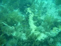
Looks very old. I wonder if there is some distortion of the picture? The angle of the flukes looks very flat.

I don't know if a book exists about anchor design and evolution. Having found many anchors with damage, broken or bent, I got an understanding of design functions. I also built a few dozens of anchors of different designs myself.... and found out the hard way what was good and what was not.
 

Last edited:
Both are Cortes... 2 of about 15... and I did not find them... just thought you may find interesting.

https://www.newsweek.com/anchors-aztec-conqueror-hernan-cortes-fleet-ships-coast-mexico-1477956

Cheese, now you got me into a p...ing contest. Thank you for the great link.
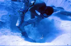
Anyway, here is MY ANCHOR!!!, me digging it out with my airlift. North of Bimini 1981.

You can see the intact wooden stock. The anchor rope was still attached and stretching out in an easterly direction. A sample of the anchor rope was carbon 14 tested in Penn-state university's lab and gave a middle date of 1490.

Sorry, I am shameless!

Eldorado anchor.jpg
 

Last edited:
003.JPG
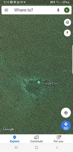
Here's one from out in front of the house....I live in side pennikamp park....many treasures are hidden in the park !! Here it is from space !!Screenshot_20190909-171501_Maps.jpg
 

Also a great find, pity it is in the park
 

Is the stock of this anchor pointing at the other two, and what the distance between them.
 

Cheese, now you got me into a p...ing contest. Thank you for the great link.
Anyway, here is MY ANCHOR!!!, me digging it out with my airlift. North of Bimini 1981.

You can see the intact wooden stock. The anchor rope was still attached and stretching out in an easterly direction. A sample of the anchor rope was carbon 14 tested in Penn-state university's lab and gave a middle date of
Sorry, I am shameless!

View attachment 1934318

Real history right there, thank you!
 

No Wreck?

The wreck has yet to be located. The 3 anchors were in line maybe 100ft or 150ft from each other. Very clearly they dropped one after the other as fast as they could while being blown upon the bank. About 40 ft of water depth. The color of the water changes from deep blue to turquois when you get on the bank. The drop off is steep.
 

Is the stock of this anchor pointing at the other two, and what the distance between them.

I know you mean the end with the stock... but you really mean the shank ring direction.

:)

:P
 

Real history right there, thank you!

I used to say: This ship found the new world before Columbus, but never made it back home to tell the story. Hemp rope had a short life, so the dating is quite accurate. Of course, 1490, 2 years before Columbus, is the middle date. If I remember right, it was plus-minus 20 years.
 

That would be very good evidence to support the theory that these guns were brought along with the first loyalist migration in 1783. I believe this earth works fort was built by the loyalist community to protect the community against a navel attack by pirates or other foreign powers of the time. I believe they mounted every gun they could muster from around the island. Some of the other guns are quite a bit older than the ones with the z on the trunions. This seems much more plausible than a pirate camp....the golden age of piracy was gone, and these guns seem to have a loyalist connection. I did find examples of these guns mounted in a fort that I believe was in nova scotia...these are beautiful pieces that should be stood up and preserved and displayed. I think with some minimal funding I could get some heavy equipment in there and get them up and out of the dirt. They would be tourist attractions if this could be done and would add to the islands ambiance !! Would be nice to get the community motivated for this and I believe all the heavy lifting and transport could happen pretty quickly. So much languishing history in the bahamas !!

Let's not forget this subject here. This cannon site is an important site. This MUST be investigated.
 

I used to say: This ship found the new world before Columbus, but never made it back home to tell the story. Hemp rope had a short life, so the dating is quite accurate. Of course, 1490, 2 years before Columbus, is the middle date. If I remember right, it was plus-minus 20 years.

Errr ahhhh... um Hemp rope was superior to all other rode... and furthermore... lasted longer than any other thing made.

Remnants of it have been found that date for 8000 years in China.

Resisted sunlight... better strength... and still to this day is the best natural fiber on Earth.
 

Errr ahhhh... um Hemp rope was superior to all other rode... and furthermore... lasted longer than any other thing made.

Remnants of it have been found that date for 8000 years in China.

Resisted sunlight... better strength... and still to this day is the best natural fiber on Earth.

I will also add that EVERYTHING on ships was made from it... for it was superior and still is.

Also... the oil from the seeds made all the paints and varnishes etc etc.

And... BOTH were also eaten in harsh hard times to survive hunger.
 

It wasnt until the political money grab war against marijuana its co-part that it ceased production and use.

OH and lets not forget the main reason...

DuPont invented the first synthetic fiber that hemp stood in the way of its selling.

Hence the "political funding" to eradicate.
 

Last edited:
The wreck has yet to be located. The 3 anchors were in line maybe 100ft or 150ft from each other. Very clearly they dropped one after the other as fast as they could while being blown upon the bank. About 40 ft of water depth. The color of the water changes from deep blue to turquois when you get on the bank. The drop off is steep.

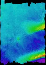
You will need to zoom in to spot the anchors, they point to the main wreck site, anchor closest points to the bow area of the wreck. The ship sank in line with the tide not the wind. Lots of wrecks were driven onto the Goodwin sands, on wrecking they were driven along the banks hitting the bank then falling back to driven on again eventually they either stuck fast or they sank down the bank into deeper water. Are the anchors resting on a solid bottom or were they sitting in sand?

Rooswijk multibeam.jpg
 

You will need to zoom in to spot the anchors, they point to the main wreck site, anchor closest points to the bow area of the wreck. The ship sank in line with the tide not the wind. Lots of wrecks were driven onto the Goodwin sands, on wrecking they were driven along the banks hitting the bank then falling back to driven on again eventually they either stuck fast or they sank down the bank into deeper water. Are the anchors resting on a solid bottom or were they sitting in sand?

View attachment 1934494

Thank you, very good observation.
The situation of the ELDORADO anchors is somewhat different. In the area where the anchors are, there is still something like one mile to where the water would be too shallow for the ship. Deep sand all the way. However, at the edge of the bank the color of the water changes dramatically, a very clear sign of the water getting shallow. I would guess, that the ship was driven onto the bank during daylight. The wind must have been very violent from the West. Maybe they had already suffered rigging damage, otherwise they could have sailed along the bank with the wind from the west.

Funny, I lost both masts of my schooner only a few miles from there in 1985.

Yes, I am sure now, the ELDORADO anchors will be my first chapter in the book about the Wrecking History Of The Bahamas. What would be nice, is if it could also be again the last chapter as a closure.
 

Top Member Reactions

Users who are viewing this thread

Back
Top