Video 4 - The Peralta Stone Maps with Frank Augustine

Oso - thank you so much for taking the time to write what you did. The dutchman world is certainly very interesting. Ive learned a lot in the 8 weeks I've been around, and I have the intention to learn a lot more. I am proud to have the opportunity to go out to these sites and to present them for folks, such as yourself. It really means a lot to me that you took the time to sign up, just to send that message.

I received another message, from a very kind gentleman, that told me he has parkinson's, but used to be a prospector in the areas I have visited in my videos. He tells me he watches my videos over and over again, because it brings back a lot of memories for him. That really meant a lot to me. At the end of the day, I'm not a treasure hunter. I enjoy people - I love to talk about things and to learn. I am fasnicated by legends and have the full intention to continue making videos. Not just in the Superstitions, but also Tumacacori and also Victorio Peak and many other sites. Frank and I are in this for the long haul, and we've got some great "guest speakers" planned for future videos.
 

Last edited:
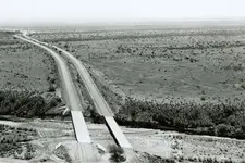
Here's a picture from the Arizona Memory Project of the
Queen Creek bridge during construction. I believe this is the same bridge area but could be the one further west. Date of this photo is 1955.

Queen Creek bridge Route 60.jpg
 

Loved the video and good to see you and Frank hooking up - he's a heck of a source to take you to some pretty cool places!

To be honest, Im pretty shocked no one has ever posted those "holes" - or even talked about them.

There's a ton of information out there that's been photographed and talked about over the years. Somehiker and I spent a half day wandering around the same spot you and Frank did and shared photos and discussion about it either here or another forum. There ain't much that hasn't been talked about when it comes to the LDM :).

Here's the only one I took with my camera in 2011 - I took several with Wayne's camera so has some more if he reads this thread. I don't remember for sure if we could ever get to a spot where we could see the Needle or not - Wayne may remember or have a photo if we did.

DSC02541.JPG
 

Last edited:
This map illustration may very well point to the history of the various artifacts found at that location.
Two of Keller's men, a soldier and a Pima guide were killed during an Apache raid on their camp site, three days north of the Gila, which was described as within sight of a precipitous range to the east.
All but a couple of the horses and mules were taken by the raiders, forcing the party to abort their journey and return to their base on the Gila River on foot.
Would a Jesuit priest order two such graves to have been excavated for the victims ?
Or would he allow them to be buried in shallow pits ?
While only Keller and a "fiscal" are mentioned in the account, there seems to be two "black robes" in the illustration.

Keller's Expedition Is Raided By The Apache Photo by airfile | Photobucket
 

That whole are is absolutely littered with all sorts of interesting rocks - enough so that I told a lapidary guy in the Phoenix area to go see if he could find something fun to cut and shape.
 

Somehiker,

I fear that you may have overlooked something worth picking up in picture #02. May I repost it annotated? Otherwise, it will be hard to point out.

If not, using the large stone as your center, look at your "one". Note that squarish pale red rock with two very clear 90 degree angles? Was it anything?

Ya mean this one Hal ?

100_0454.JPG

If so, not close enough.....

This one was though.....

View attachment 100_0568 heartshale.bmp
 

Last edited:
Is that this? Upper right hand corner, squarish pale red stone.

photograph #02
somehiker

No. It's the one in the center of my shot.
Many stones out there have squarish corners.
At the time, I was mainly looking to get a photo of the differing types, rather than any which appeared to have been worked by hand.
 

That whole are is absolutely littered with all sorts of interesting rocks - enough so that I told a lapidary guy in the Phoenix area to go see if he could find something fun to cut and shape.

Sure is. And as you know, some can be very unusual indeed.
The item you spotted on the pile of excavated material at the one "grave sized" hole for instance, may have been directly related to one of the unfortunates who did not return from Fr. Keller's entrada........something to think about !!
 

Oso - thank you so much for taking the time to write what you did. The dutchman world is certainly very interesting. Ive learned a lot in the 8 weeks I've been around, and I have the intention to learn a lot more. I am proud to have the opportunity to go out to these sites and to present them for folks, such as yourself. It really means a lot to me that you took the time to sign up, just to send that message.

I received another message, from a very kind gentleman, that told me he has parkinson's, but used to be a prospector in the areas I have visited in my videos. He tells me he watches my videos over and over again, because it brings back a lot of memories for him. That really meant a lot to me. At the end of the day, I'm not a treasure hunter. I enjoy people - I love to talk about things and to learn. I am fasnicated by legends and have the full intention to continue making videos. Not just in the Superstitions, but also Tumacacori and also Victorio Peak and many other sites. Frank and I are in this for the long haul, and we've got some great "guest speakers" planned for future videos.

As to the sponsorship that my buddy AzDave spoke of, he is correct. Its such an honor for both Frank and I. We will be making that announcement in our next video. We won't be commenting on anything related to that, I'm sure you can understand.

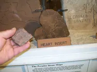
As to the rock Frank found - I think its pretty awesome that he found that. We've never promoted that rock as a definitive "stone map piece" but we do feel like it matches the stone(s) used in the Stone Maps. Its odd that it was found at the dig site, and it was the only rock we found after a substaintial amount of time trying to find others like it. Its been chiseled and looks to be worked by "someone". At the end of the day, its just a rock - but I will tell you, Im pretty proud that we found it.

You don't have to Dave has it covered. Ho, ho, ho.
That's just a rub Dave. : )

Seriously, could either you, Frank, or Dave explain to us what you are describing as "chiseled". That implies that the stone in your picture was worked with metal tools. I didn't see evidence of that in the video or the photographs. That may sound like I am being confrontational but I am only asking for clarity. If not for me, for those who watched your video and may be somewhat confused.

Perhaps just worked? Lots of stones were worked by natives for thousands of years.

Here is an example of something that has been worked with modern tools. Strange as it may be.

Thank guys!
 

Last edited:
Stone map location.jpg

Hal,

The exact location of where the Stone Maps were discovered has been disputed time and time again. There are no less than 5 different stories and locations where different people have said Travis Tumlinson (or others) actually found the Stone Maps. Travis Tumlinson found the Stone Maps in the year 1956, that much has been established and is not in dispute. Many of the things Travis Tumlinson allegedly said about finding the Stone Maps were actually said not by him, but by others on his behalf. Things like stopping to get a better view of Weaver's Needle and stopping at that spot to relieve himself, among others. The "Tumlinson map" has had things drawn and added to it by others over the years depending on which or who's copy you might have seen.

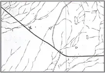
Any search of the area believed to be the place Tumlinson found the maps must first establish the exact place he actually found them. A map is said to have been used / drawn by Travis Tumlinson with an x marking the spot where he stopped along a highway and found the Stone Maps. Some have stated this Tumlinson map is hand drawn, others have said he used a topo map. The map is neither hand drawn nor a topo map.

The map allegedly used by Tumlinson, and allegedly marked with an x by Tumlinson, is a part of a Pinal County Water resource and management map for the Queen Creek, Apache Junction, Florence Junction, .... district. The map was designed to show and highlight creeks, drainages, ponds, natural tanks, stock tanks and wells. The map is dated 1969.

Matthew
 

Top Member Reactions

Users who are viewing this thread

Latest Discussions

Back
Top