TWO SIGNS LEFT TO I.D. MINE, AS SPANISH, FRENCH, OR JESUIT.

In other words you are pretty close to something, it may be gone, it may be there (it's probably still there). But you will have to find the spots nearby that things start to line up to or look at or suddenly appear from a certain spot you stand at. Owls can have things very close by, as well as further off, they are very key in all these sites and can lead to multiple spots, especially the larger ones. They will line several things up off them, but usually there will be other things once you are next to the spots they are guarding/marking. I always call them the guardian of the underworld and the dead which is the ancient meaning. 13's often come into play alot with them, distances, bearings,etc, like 13 off a cardinal or 26 (2 x13) or 39 (3x13) in feet or 39 degrees (but it doesn't need to be), the owl was the heiroglyph for the 13th letter of the egyptian alphabet if you recall, I think it's been said before anyways (as well as the M shape in many alphabets).
 

Last edited:
Have you looked at it up side down? Mikel is there a creek running between two bluffs.
 

That's a lot to take in... i'll have to make some notes to my notebook, for sure... for next trip...
an Bob, there are a bunch of deep cut streams on the map.... some with one bluff, one in particular that is out of reach, legally,,,/.

#/;0{>~
 

Sometimes the owls are really a cat, but the ears are pretty much the same. Often they will be made by a pointed rock shoved into a crack and its the negative air space or silhouette of an owl. It doesn't have to have eyes. On the larger ones the ears are pretty important. Often there will be things that line up from different angles thru the ears. On large owls there can be peepholes or notches to look thru right between ears, or off to the side of the actual owl, or in some cases multiple combinations. Sometimes the ears themselves line up sideways across each other to another marker or a spot.

They liked to place these owl monuments along cliffs or on hillsides for a reason, Another good way to use a larger owl monument would be to walk out in front of it in a semi circle arc while paying attention to what is seen above and between its ears from different angles. Often times there will be a makeshift eye or something representing an eye like a rock wedged into somewhere with gaps on either side of it like whites of an eye, or sets of eyes from an image (like part of skull , or kings head or animal ) that are looking thru the ears at a spot across a canyon or ravine or even some where very close by. They can be done in lichen or as cuts in rocks that are seen as shadows. Often it is easier to see them from pictures you take, but you can see them in the field as well once you are aware of them.
 

Last edited:
Well, working with the historical society has brought some hard evidence...

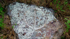
Note that this is a different stone marker, just a few miles from our keystone!!

ImageUploadedByTreasureNet.com1517690766.789771.jpg

The center line points toward the keystone!
#/;0{>~
 

Last edited:
Howdy Mikel,

You know the mine or treasure is big when the location is etched in stone. Good thing you didn't publish the book earlier, now with all the new evidence you have uncovered, it will be "the" book to read for all treasure aficionados.

Homar
 

Yes, old amigo. The help of one person has closed a big leak.

When Weekender and I went through the work for the landowner where the Keystone lies, the last thing that I expected to see was , the five (fingers), that point south, pointing to the Keystone. It can really prove what seems obviously clear and accurate.

I have discovered more, incredible images in and around the area of the king’s head and the man that you thought was Weekender...

So many small things that demand an intense study of each and all as a group.

These are a small part of my absence from the Jose documents ( by comparison) very minute part.

I hope to hear from him, or someone near him to assure that he (still) feels up to reading it. I have an approval through an unseen person, and there are many people who just don’t understand that he made it known by the use of the LIKED when he saw it was moving forward.

And not LIKE the stress and confusion.

Timing is important and when the time is right, I will drop everything else to launch it.

#/;0{>~

After looking back, I realized that I had missed post #6169! That is crystal clear positive response!

I must go through my PMs to and from the mods and then, get all of my ducks in a row!

After a good night’s sleep and haves clear mind.

Gotta get busy!!!

Mikel
 

Last edited:
I have been studying some “documented “ history about Hernando de Soto, and his time in Arkansas.

I have found one set of documents that traces his trail from around the Branson MO area, headed south through areas that were named by the native tribes, long ago. Historians don’t always agree with one another, but they do have common ideas from journals kept by different officers and priests.

The number of men that were with him on his last expedition was surprisingly high.

He started out with 800 to 1,000 men, and numerous ships.

By the time that he passed thru northwest Arkansas after crossing the White River, he was down to 300 to 500, men including horse soldiers, foot soldiers, priests with their support personnel, shipmen, builders, hunters, scouts, cooks, and blacksmiths for the horses and even native prisoners that he kept for translation from one area into the next. The translators would be released once they were of no further use to them, and were replaced as local language barriers would come and go.

The tribes that were recorded from our area were reported as having no translation available due to their hostility and they were so fierce that they chased the expedition back across the White River to the point of marching through the night and sleeping on the trail due to fear and exhaustion.

Once regrouped and reorganized, they returned and battled them into submission. De Soto recorded that they were the most fierce tribe that he had ever encountered.

The trail that some historians recorded showed their trail coming within twenty to thirty miles of our site, with at least three hundred personnel.

After resting from battling the natives into submission and scouting the area for food and supplies they moved south and then to the east, where many things went wrong over the next year or so.

De Soto spent the rest of his life trying to escape from the area that became Arkansas. His men split up after burying his body and coming back in darkness to remove it and wrapping it into sand laden hides and giving him a burial at sea ( the middle of the Mississippi River,) to keep the natives from taking his body to prove that he was just a man, rather than the “ Son of the Sun” (a god,to be feared by all).

His remaining personnel split into two parties, one to find a way back to the sea, and the other to walk on the land in search of “New Spain “ to the west.

These are the most commonly agreed upon points of the material that I have been able to track down, so far.

There is supposed to be a document that states, that they were in Madison County, but I have not seen it yet.

I’m still looking....

#/;0{>~
 

Last edited:
That’s some great background info/ history
 

That’s some great background info/ history

Yes, MARK 60, it has been a lot of research, and I have only scratched the surface, here on thread.

The de Soto/ Vaca relationship led de Soto on a long expedition to concur , of all places, the continent of Florida!

He believed that, by marching northward and westward, that he would find the “THE GREAT NORTHERN SEA” and build new ships to sail to China.....

He was so lost, that when he reached the western edge of the Mississippi River, at full flood stage, he wasn’t sure if he was close to the unrecognized Gulf shoreside or at one of the great seas in the land that he knew only as Florida. As described to him by de Vaca, when he was much younger.

His native guides and translators were only trying to guide him away from their homes, so they told him that what he was looking for was in another place and let him think that he would be there very soon...

He was most likely much closer to the Gulf of Mexico than he thought, after his death and reburial at sea, the midst of the flooded Mississippi River, where his crew weighted his body to sink in the fast moving currents, as an attempt to keep the natives from digging him up to prove that he was not “The Son of the Sun”, to be feared forever.

There is much more to study!!!

Mikel
#/;0{>~
 

So much for all of the research on de Soto.
Almost all of the records reflect that he passed thru this area in a concentrated effort to head south.

I have found information, that indicates that our party was headed north..,

It doesn’t really matter which way they were headed, they were here for quite some time.

Too many details to be a fly by night operation...

#/;0{>~

Thats very interesting. Its alot of work and time(i would guess) to dig the mines,process the ore.Then bury and mark the caches. Maybe done by another group?
 

Dog, it may have been done by more groups than I have the ability to count, let alone identify.

I have yet, to figure out if the last fourteen years, have been a blessing or a curse.

It seems that I may be good at never giving up, and only a little bit good at figuring out...

One thing that I am sure of, is that this kind of hobby is for folks with a little less silver in their hair.

#/;0{>~
 

I have much to bring to the surface, after Weekender and I spent most of last Saturday’s expedition to our site.

For now, I’m recovering.
And I have learned to be less vocal, and more reflective during my recuperative time.

However, should Weekender wish to share from our expedition, I’m sure that you would be spellbound to watch it unfold. For me... well, it’s time to take my medicine again.

I will crack that hatch [emoji214] when I’m less afraid to be sucked out of it.

#/;0{>~
 

I know that it has been a while since I’ve posted, but unmediated times are few and far between, and I’m still trying to figure out what went wrong! It’s been hard to explain.
Hang in there till I can see it through the smoke and mirrors.

Thanks

#/;0{>~
 

This year’s expedition was to be simple, but technically demanding.

It was based on taking our time and making a sound path (Documenting) last year’s amazing discoveries.

We kinda made some mental and notes as to the method that was based upon Weekender’s awesome instincts.
I was busy trying to not slow him down.

The results of last year’s , touch and go, movement lead us to the most important and exciting find of them all!!!
The raven, the hallway, the stone man at the end of the hallway, the stone bluff above the stone man that had the large 7, and the large cross (and a few more in that one photo that we have not mentioned in public yet)

The stone head looking at the water fall, that vanished into the floor somewhere... Then around the next corner where we found the two sculpted heads, one was covered in just the right places with a different type of moss that created the look of hair... facing another, even larger head with an open mouth with teeth in it , and a thick moss covered smooth band around his head ( with a hidden in plain sight image of the skull bluff, that is about two miles away)

And the almost missed, circle of stones stood up on their ends and plastered together, to create a crown.

There is one symbol that we have not discussed, that is undeniably the work of Masons.

Yeah... That one jumped out in one photo!!!

Go ahead and say it... “Why didn’t you mark the GPSes (2)?? Neither would get signals !!

We were sure that we could repeat the trail from 11 months ago.

<><><><><>>><><>><><><>><>

Six to seven hours riding in two seater side by side, gave us every advantage.

I even tried to become invisible to Weekender so that he follow his instincts..... at one point he asked me what was different this time? And my only thought was that this time, I brought a shovel!! And had a plan to use it......

I have tried to make a chapter for this info but when I started the Chapter 24 I managed to get a good start on it and saved it, my laptop either deleted the last two chapters or the files.
Either way my work has grown, and my time that I spend posting here comes in short time slots,

But I need to keep you folks informed.

And that’s the news from Madison County, where every other shovel full is a rock...

#/;0{>~
 

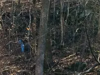
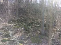
Weekender and I, did get a few photos. Most of his were of the areas that would be most likely the spot.
Several of my photos were of him walking up and down the hills...
ImageUploadedByTreasureNet.com1525068354.406549.jpg
, ImageUploadedByTreasureNet.com1525068398.465303.jpghe is in the upper left quadrant ...

Notice that I stayed pretty close to the 4X4 , I walked down the bluff line in search for the circle of stones to make the crown.

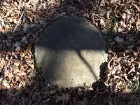
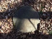
I did find a few oddities, this is a flat, round stone, about four to five inches thick. The edge is a conglomeration of pebbles and the bottom looks like just about any of the stones that you will find in any forest in the Ozarks.
I can nether confirm nor deny, that it could be part of an old arrastra ...
ImageUploadedByTreasureNet.com1525069560.512604.jpg

Well, that is about all that I can post tonight.

So..... more later.

#/;0{>~
 

I have been thinking about that round stone, that I found on our site.

One thought is, it may have been a capstone over a small pozzo. It is large enough for an air vent.

It is too small for an entrance, so It may have been from the level above the one that Weekender and I were working. That is if, it got away and rolled over the bluff that Weekender was working.

That was a long thought....

Another thought [emoji189] is that I really should have at least measured it.. but I do remember that when I stood it up on it’s edge, it just touched the bottom of my kneecaps. That is eighteen inches +/_ an inch.

Yet, another thought, that won’t leave me alone is that the outer edge is a conglomeration of small pebbles and hard clay.

Altogether, too much to ignore. Clearly man made!

Just another Ozarks mystery, where every other shovel full, is a stone.

#/80{>~

I was going to repost that photo, but Google has been moving my photos around to what they think is best!

Found it!!
ImageUploadedByTreasureNet.com1526855477.348627.jpg
 

Last edited:
Yet, another thought [emoji189].
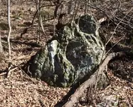
This close up of this Stone throws the size, a little out of proportion with another monument that we didn’t think about. Mostly because we didn’t think 🤔 that it may have been a damaged monument from an older sentinel, trying to throw us, or even an earlier expedition by another party, off the trail...

ImageUploadedByTreasureNet.com1526905063.098730.jpg

The round stone, may have fit into the spot at the top of of this ( yet unidentified) monument.

Our mission to find the trail to that amazing room, which had both of our minds locked on reproducing that trail, to stop and look deeper into connecting those two stones....

If the disc was part of the monument it might have sent us to the trail.

Weekender was focused on, what looked very much like the area that we were looking for, which was above the monument and the disc that I had found, and failed to put together in my own mind!

Possibly a catastrophic failure on my part.
But, it could have been a successful manipulation of an earlier sentinel’s work, to throw an earlier expedition off of the trail.

I keep thinking that we may be victims of a single problem, with a single minded group that have thwarted, many attempts to find what we found the previous year.

Here I am, in the midst of a conspiracy theory! Stuck mentally and physically, brought on by my own health issues, that have kept me from moving forward ( other than the discoveries that Weekender has led me to) for most of a decade....

Don’t be surprised if you see this in chapter 24...
It has been very difficult for me to write, for some time now.

Every time I have tried to write anything about that expedition, I get lost within my own reasoning and our lack of results.

That day has been stuck in my memory like nothing else has, for a very long time.

#/80{>~
 

I have been thinking about that round stone, that I found on our site.

One thought is, it may have been a capstone over a small pozzo. It is large enough for an air vent.

It is too small for an entrance, so It may have been from the level above the one that Weekender and I were working. That is if, it got away and rolled over the bluff that Weekender was working.

That was a long thought....

Another thought [emoji189] is that I really should have at least measured it.. but I do remember that when I stood it up on it’s edge, it just touched the bottom of my kneecaps. That is eighteen inches +/_ an inch.

Yet, another thought, that won’t leave me alone is that the outer edge is a conglomeration of small pebbles and hard clay.

Altogether, too much to ignore. Clearly man made!

Just another Ozarks mystery, where every other shovel full, is a stone.

#/80{>~

I was going to repost that photo, but Google has been moving my photos around to what they think is best!

Found it!!
View attachment 1592567

Hi Mike. Next time you get out there, you might want to brush the leaves back a few feet and look for a small pie shaped stone pointer embedded in the ground and pointing toward the round stone. This could give you a line and if there is such a setup, you might want to detect at least a couple hundred feet out from the round stone.
 

Top Member Reactions

Users who are viewing this thread

Back
Top