Treasure Signs and Symbols 101

Goodyguy

The train robberies that were alluded to at the beginning of this thread has me curious as to whether or not the Famous Reno brothers from Indiana were a part of the conspiracy or just independent outlaws. Perhaps you could shed some light on that for me.

I dont know about the Reno brothers connection, but according to Dign, some of the robberies were ordered from the top down,..and gave these guys lots of cover.
As for the case you are interested in, Digns theory says that close to these hold up spots are the central cache places, and later were made in to a park or wilderness area,to protect them, so just check to see just how close the nearest park or "public" National Forest etc.
Hope that helps a little!
rangler
 

Goodyguy said:
Cache Crazy said:
Part of the Reno brothers' gang fled to Canada before being captured. The loot could be just about anywhere.

Yes but that was an earlier train robbery where several of the gang went to Canada.
I am referring to the last train robbery when all remaining gang members were caught within hours and the loot was not recovered.

GG~

:thumbsup:

My X is from Austin, so I'm somewhat familiar with the area. You never know, it could be there.
 

True TH, Argonauts
Some information about the nature of these codes:
They ARE ultimately solvable! They were meant to be, oh not by just the casual observer..but by the dedicated argonaut who will invest what ever the necessary time needed to complete the task.

The reason the code was designed to be broken , was as a security feature, sounds oxymoronic does it not?, But the idea was that if the Code Book was lost or destroyed the thousands of mines and caches would be lost forever. Then the stone monument who stand for a few centuries,and could be broken by future generations by knowing that the code was built on the following principles
1. Natural Sciences
2. Mathematics
3. Golden Geometry
4. Astronomy
5. Cartography
6. Archaic Languages & Cultures
7. Celts, Pagans, Romans, Greeks, Aztecs,
8. Templar's, Masons, Egyptians, Amerindians

The foundation of the code is knowledge of all aspects of higher learning. With research and study
each level of knowledge brings you closer to breaking the Code. The average time for independant study is about 20 years, as this Code cannot be broken by skull drudgery alone - you must be in the terrain, with boots on the ground (BOTG), and you must learn the mind set of the Code Makers, to walk in their shoes, to see things as they saw them.

Now add Intuition and Faith to the equation , intuition is a key player in this, because many times in the trail suddenly ends, with no apparent continuation, this is done on purpose to lose the uneducated ones, a Leap of Faith is required, and it is your keyed up sense of Intuition that helps you make make the appropriate decision,luckily you can use trial and error here to get passed the gap in the trail, it might take years but it can be done. Many are foiled right here.

One of the reasons I dug up Digns posts is that he, was the only one to lay this information out for all to see, he had no greed or malice, unlike many I see here..his detractors were legion, everyone jumped on him from the greedy black hearted ones to the naysayers to negative ones, they alll gang banged him to the point of frustration, That will NOT happen to me..with the help and support of all you True Treasure Hunters, we will overcome, adapt and persevere!
more later on the Code
rangler
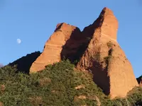
The pic below is from another thread on this site, it is taken in Northern Spain, one of the longest running gold mines in the Old World, I posted it because at one point in time , it was made into an Alpha Monument, I am sure the goods are long gone, but the monument is a good teaching example of the early monument makers, while there is no Hoyo visable from this angle anyway, the confirmation marks are here, take a look and see what you can pick out. This will help focus your attention to the hiddenin plain site signs!! Have fun

800px-Image-Las_Médulas_con_luna.jpg
 

Attachments

  • 800px-Image-Las_Médulas_con_luna.jpg
    800px-Image-Las_Médulas_con_luna.jpg
    97.4 KB · Views: 12,151
Here is a post from Dign about the Mission system..

A History of the Mission System

(05/29/06 8:30 AM) ancientlosttreasures.com


Most treasure hunters don't really give much thought to the system of Missions that was so dominant here in America, as well as throughout the world. Mention the word "Mission" and most, if not all, people will have visions of treasure running through their minds. And, to be honest, that vision of treasure is very close to the truth about this system. But there is a lot more that needs to be understood about the Missions, mainly because this very system is still alive and well to this very day.

American History, as it is taught in our schools, is a complete joke. There is very little, if any, truth to anything that has been, and is still, being taught. The history of the Missions is not even discussed, yet it is evidence of the reason for the very "discovery" of America. And Christopher Columbus?? We won't even go there!! (ed note: I did go there, lol see my post "Land of Ophir and the Ancients Ones)

The history of the Mission system is a simple one. You move in to a place that is rich in natural resources, establish a few buildings, then proceed to manipulate the people and oppress them as you "remove" these resources. These resources are then used to control the growth of the New World as more and more people migrate into the land.

Most people feel that the Mission system died out a long ago, along with the Spaniard. But that's not the case. The Missions are very much alive and doing well, it's just that they are no longer called Missions. What was once called a Mission is now called an Embassy. And while the name may have changed, the "mission" has not changed one bit. In fact, we see an excellent example of this modern day "Mission" building in the Country of Iraq.

It was revealed in todays newspaper (5-29-06) that "a lavish U.S. Embassy" is being built in Iraq, on the western bank of the Tigris River. The article states that the peoples of Iraq are experiencing rolling black-outs, yet this Embassy has electricity 24 hours a day. It also states that the rebuilding of the country has not even begun yet, but the building of this Embassy goes on without delay. The people of Iraq go without food and water, have no homes to live in, yet the U.S. Embassy rolls right along!! I mention this example because it is such a perfect example of exactly what the Missions did to the Native Americans!! Same Mission system, same plans, same outcome, just under different names.

The Missions of old took over the land, the peoples, and the resources in that land (not to mention the politics, the finances, the religion, etc.). And I ask you, how does the old Mission system differ from the new Embassy system???
~~~
editors note:
Report from Old Mexico, a man I know to be a person of his word, told me years ago that
the Missions there were distribution systems of the golden inventory, shipped from one to the other, as time and circumstances permitted, eventually toward the coasts of Mexico and waiting Galleons to ship the goods to the Pope and the King of Spain..

Lots of these warehouses were shut down mid shipment- there goods stored in what was called 'Galleries' beneath the Mission itself, in the case of the Missions near the sea coast a tunnel was dug from the galleria to the water, to be able to load the Galleons under cover of darkness and without the drama of the locals. These tunnels had very elaborate traps to hide and dispose of the goods.

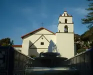
Below is a pic of an unnamed mission that displays architecture that gives cluse to how the goods were hidden within what type of geometry. In fact Dign has written a post about hidden clues in the architecture even in some public buildings! Look for that post to pop up later, I wil post this same pic to remind you..

Here in this pic, hidden from the street view, is the triangle shape, telling you that the Caches and Mines under the dominion of this Mission , the final Geometry was laid out in a triangle, and that the mandate was that the good be buried in the center of triangle. The confirmation is that the square in Code comes from the Arcane knowledge that meant 'earth' the Codemakers pushed it one step farther to mean "buried in the earth"!

The reason for this was so that the information would not be lost if the Code Book was lost or destroyed , and if the Padre was to meet an unfortunate end at the hands of the local neophytes or as we know them ..Amerindians, the vital message of the Omega monuments would not be lost./
Hidden in plain site..to make the obvious fade in to the architecture..HA
 

Attachments

  • mission.jpg
    mission.jpg
    33.5 KB · Views: 12,110
" These tunnels had very elaborate traps to hide and dispose of the goods."

Were these traps just to hide the Goods or were they also traps to Kill.
 

Correct Thom

A good friend of mine had extensive experience with this in a Mission on a river bank in Mexico,
The Mission had the tunnel all right and he located the stash by dowsing, , an attempt to breach the tunnel at midpoint failed as the tunnel was water trapped and it flooded, the goods were on a type of pallet on top of slippery clay, as the force of the water flooded the tunnel the goods slid farther down in to the depts of the river bottom. He is still trying to figure out a retrieval method
rangler
 

Rangler, That Triangle with the Square in the middle, Just like the one in front of the Church. The square in the Middle is the Window. I have seen a Triangle with the square in the middle Chiseled on a boulder in the Field. "What does it mean. " What you are saying makes sense. Also look to the upper right tower where you can see the Bell. See the Out line of that window/port with the Bell. Square and round on Top. That is the shape of the Tunnels. Also about the same Width and Height. We once found one by Accident. Very creepy. Covered it back up never looked for it again. Wasn't near a church. Old Hacienda.
 

OK, Im new at this treasure hunting thing, but Im willing & want to learn. :icon_study:
My first objective is to find an Alpha. How do I do this?
Ive got US Topo maps from 1906 for my area. Would I be able to find an Alpha on these maps?
 

Victorio
rangler, That Triangle with the Square in the middle, Just like the one in front of the Church. The square in the Middle is the Window. I have seen a Triangle with the square in the middle Chiseled on a boulder in the Field. "What does it mean. " What you are saying makes sense. Also look to the upper right tower where you can see the Bell. See the Out line of that window/port with the Bell. Square and round on Top. That is the shape of the Tunnels. Also about the same Width and Height. We once found one by Accident. Very creepy. Covered it back up never looked for it again. Wasn't near a church. Old Hacienda.


What does it mean.
It means that the final geometry from the Omega will ALWAYS be a triangle, now on the Omega, normally the information there will tell you what the final geometry lay out might be, a Triangle, Square, etc, then you have to determined WHERE on the triangle the goods are stashed? Without that you could dig holes all over an acre of ground and not find anything but rocks and dirt.
With the Triangle as part of the Architecture the Final Solution was stated well in plain site. Now the most important part, with the square in the middle, the mystery is gone..the Square IS the code for cache. I told you
in my first post where they got this from .. it is confirmation that it is correct.
They hid the same types of clues in paintings found at the Missions, more on that as it comes up from Digns posts.
The codemakers favorite trick , hidden in plain site!
rangler
 

Welcome to the club :thumbsup:Snizzard

OK, Im new at this treasure hunting thing, but Im willing & want to learn.
My first objective is to find an Alpha. How do I do this?
Ive got US Topo maps from 1906 for my area. Would I be able to find an Alpha on these maps?

You need a map dated 1606! lol and even then it would be coded.
If you need assistance, I suggest that your first step to do this..
1. Click Ignore on SWR
2. Click Ignore on Lamar
Check this thread often for the latest on who to Ignore
You will just have shortened all posts of unnecessary filibuster type naysaying and shorten the time
you need to get up to speed on the Treasure Hunting Hobby..
3. Go to the Posts of OLD DOG, our buddy Thom, read ALL of his posts, look at all the pics of
Trail Markers and Alpha Monuments, he is astute enough to tell you which is which.
4. Once you read all of his posts, read all of Digns, StillDign and Dign4it, posts here and any where
on the net that you can find them, take notes, make bookmarks, for later reference.
5. About that time you will be ready to check back here and ask some questions about what you have
read, Thom will be more than wiling to help you as well.
6. If you live in the southwest, finding a Alpha is pretty routine..but first you will need to learn HOW to
recognize one..I hope you like to read, because right now that is your job, input input input..
7. Look at the pic I posted here about the pic in Northern Spain, it is a very subtle Alpha Monument
when you can spot what makes it an Alpha you are ready for your first pair of about 20 pairs of
boots.
8. Buy a digital camera, min 5 megapixels, you probably will not be able to recognize an Alpha when you
first see it. . at least not the confirmation signs, that will be done under maximum zoom on your pc.
9. Get some of Kenworthy's book on Treasure Signs, go to Treasurehunteruniversity.com check Hawkeye's
stuff, Mary Carson book of signs, and others
10. Get out there and have fun hiking any historic trails, in gold country, or areas of mineral deposits. Look for
outcroppings, large stacked boulders, animal faces, people faces, hearts, hoyos, numbers, letters, etc
Tune in often when your online, stay up with other people posts who want to teach you something. This is a great hobby it will not take you too long to understand that the REAL treasure is being outdoors in the sun, getting fresh air and exercise, a time to commune with Mother Nature, bottom line the......
Journey IS the Destination. If you get to experience that golden glow, then that is a bonus.
rangler

..."the journey of a 1000 miles, begins with the first step"..... ancient Chinese saying
 

Thanks again Rangler. That Alpha picture the one with the Mountain. Is that " M " inerva.
 

Thanks for posting this in one place, I have spent much time weeding through old posts to read it.

The really difficult part for me has been the fact that the area I am in, has been hydraulic mined during the 1800's gold rush. The topography has changed substantially, nothing is, as it was before. Rock is moved, ground is moved, and even if I find certain markers, I can easily be deceived, because the miners shifted things so greatly. It's nearly a lost cause because of this. The only hope I have with it, is from the mining era, IF, anything is there.

The way they changed the waterways for their use, blasted the ground, moved the rock, blasted the rock, I feel as if the markers will be going the wrong ways, going no where. I have seen obvious markers, but alas, the rock they are in, has been moved, and moved again.

This area, is nothing like the deserts, it is mountainous, forested, and heavily vegetated. I think that so much has been moved by people that came before and didn't know about it, that perhaps, some of the greatest things will remain lost here, because of marker movements by pure accident and unknowing.

My quest, however, continues, and I deeply appreciate the valuable education I am receiving here, and I am able to decipher what is ultimately valuable information, and thank those who wish to help others, here on Treasurenet.
 

inform..
you wrote..
This area, is nothing like the deserts, it is mountainous, forested, and heavily vegetated. I think that so much has been moved by people that came before and didn't know about it, that perhaps, some of the greatest things will remain lost here, because of marker movements by pure accident and unknowing.

Sounds like you are in Northern California Gold Country,.? Just guessing but if so..step away from the Hydraulic
areas and get down on the stream beds where only placer and hardrock mining was done, sure some ground sluicing, called booming, but the rock monuments are there..take a gold pan and some binocs and enjoy a hike up the auriferous rivers of NorCal

9993.jpg
(c) copyright 2007-all rights reserved-may not be duplicated or copied-rangler
This is a a cropped pic of a Janus Monument, from NorCal, this Monument has a face looking East and West
it is the Greek god Janus, the gate keeper...The Codemakers used it to mark the Begining of the Treasure Trail


Here is a couple of hints for you ......

1. Most all gold bearing streams have a high and a low trail paralleling the rivers course, in the old days the low trail was used for packing out and the high trail for packing in, as these trails are only a foot wide in places and they drop of hundreds of feet in places...both trail are good for looking for monuments.
2. Some of the earliest explorers and argonauts where in California as early as the 1500's, ( Spanish wave that is..some Anceints much earlier) The early monuments were pretty big and bold you might overlook them as the relationship to the King of Spain deteriorated, the Monuments became more subtle, like they were obeying the spirit of the Law not the Letter, in that the shadow signs are ONLY visible during the noon hour + or- an hour!! The set with the equinoxes', meaning they are only visible from spring to fall. Thus limiting the time even the Kings recovery crew could see these Monuments! This upped the odds that the caches and mines are still there..although many Mexican miners reopened those close Spanish Mines with the Explosion of the Jesuits in 1767.
3. Look at your county maps of all the known gold hard rock mines, ( as these were often old Spanish mines or near the mineralized areas where the Old Spanish Mines were) pick a couple close to you even as high as 4000 feet. The Spanish closed their hardrock mines and often hid their tailing piles but the Monuments where purposed stacked carved and in place until this day..that is what you want to look for.

4. Look for large outcroppings! dont just look for boulders or stackes of boulders. Walk the trails on the South side of the River if you have the choice..take photos of all tall outcroppings with marked shadows on them
and or hoyos, take these back to your pc, Zoom in and crawl all over looking for the usual suspects.

Good Luck, be careful and have fun!
rangler


........."Yet it isn't the gold that I'm wanting. So much as just finding the gold....Robert Service, from "The Spell of the Yukon
http://books.google.com/books?id=d9...X&oi=book_result&ct=result&resnum=11#PPA12,M1
 

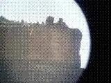
this is another of my crappy phone pics through my frog finders it is what i believe to be an alpha with a hoyo. it is on top of a peak with a vertical cliff face 360 deg around bout 50 feet tall the hoyo is only visible due east from the monument. pic is from about half a mile away through 8x binocs. my question is what information does this impart to the spaniard back in the day and to the T/H today? in my tooling around out in the field i have come across more of these such monuments than i can count in about a 150 mile air radius. untill i discovered this site i always thought them to be a curiosity but irrelavent in the long run. any thoughts?
 

Attachments

  • twin peaks 1.jpg
    twin peaks 1.jpg
    5.7 KB · Views: 14,219
Rigmover,
Appears to be a Trail Markers (not an Alpha) hard to be certain but Trail Markers need to be placed
in places like this, were you stated it was a half a mile away..Alpha Monuments are more accessible
and more tucked away..I am sure that Thom, (old dog) will agree, and I defer to him for his
confirmation.
rangler
 

rangler said:
Rigmover,
Appears to be a Trail Markers (not an Alpha) hard to be certain but Trail Markers need to be placed
in places like this, were you stated it was a half a mile away..Alpha Monuments are more accessible
and more tucked away..I am sure that Thom, (old dog) will agree, and I defer to him for his
confirmation.
rangler

thats what i meant, trail marker. i misarticulated. had too many trains of thought running concurrently. thanks for the correction.

if this tells one that they are on the trail, that would be subjective to direction of travel wouldnt it? most of these i have seen are visible when travelling north or west. do they mean "continue on " or"go that way" is the "hoyo" directional at all or simply confirmation to the marker?
 

Dear Rangler,
How in the world did the Templars become involved in all of this? I can kinda-sorta see how the Jesuits could be implicated, but the Templars???
 

rigmover2307 said:
rangler said:
Rigmover,
Appears to be a Trail Markers (not an Alpha) hard to be certain but Trail Markers need to be placed
in places like this, were you stated it was a half a mile away..Alpha Monuments are more accessible
and more tucked away..I am sure that Thom, (old dog) will agree, and I defer to him for his
confirmation.
rangler

thats what i meant, trail marker. i misarticulated. had too many trains of thought running concurrently. thanks for the correction.

if this tells one that they are on the trail, that would be subjective to direction of travel wouldnt it? most of these i have seen are visible when travelling north or west. do they mean "continue on " or"go that way" is the "hoyo" directional at all or simply confirmation to the marker?

Trail markers that have hoyos are usually directional.
They are sight specific as well, they give a limited view of a very small area.
One that may be cluttered with similar things that will distract the viewer from what was placed there to look at.
The hoyo helps one discriminate from all the fakes by focusing the view on a small given area, or even a single sign.


Trail markers of the type you are showing are made to be visible when standing under or next to the previous.
I have some locally that stretch from hill top to hill top with three or more miles between across the plains.
They were meant to be followed from the bottom of the valley and can be seen one from another in both directions.
They only indicate a course of travel that was mainly used for travelers and supply caravans.
We have since located a few that almost covertly extend to the south and take a much different route than the main established trail.

The alpha markers for these trails would be around Mexico city or somewhere on the Baja peninsula.
there would be no omega as the end of the trail is only a turn around point.
 

lamar said:
How in the world did the Templars become involved in all of this? I can kinda-sorta see how the Jesuits could be implicated, but the Templars???

im kinda with you on that one. the idea that a group that ceased to exist as a powerful entity 200 yrs prior to exploitation of resources in the americas had anything of importance to do with said exploitation is laughable at best.
just because i build a rock wall around my house in a pattern common to ruins from 1249 ad to 1283 ad and use era correct materials does not mean that i must be of Anasazi or Mesa Verdean descent to create such architecture. i saw it once thought it looked neat and recreated it to suit my own purpose. the point is just because somthing appears to have connections to the knights templar dosent mean that does, perhaps someone just thought it would look cool
 

Top Member Reactions

Users who are viewing this thread

Back
Top