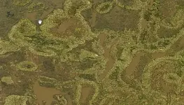
treasure on google earth


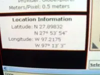
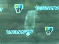
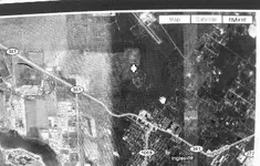
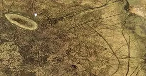
now if i was to goggle these pictures i would get a plain looking shot of a sandy field....however...using some satellite shots with some infrared filters provided by
the company who's name is on the screen.......i get this......and i gave you the coordinates so you can go there and see it for yourself...and i wonder what it would look like if you go over your finds with these filters ...since you already have a surface that looks like a ship...which mine doesn't... :wink:....and that's all I'm gunna say about that....
Limo Bob :icon_pirat:
 

Attachments

  • best damn satalite shots you never had 2 006.jpg
    best damn satalite shots you never had 2 006.jpg
    20.9 KB · Views: 1,859
  • best damn satalite shots you never had 2 004.jpg
    best damn satalite shots you never had 2 004.jpg
    32 KB · Views: 1,886
  • best damn satalite shots you never had 2 005.jpg
    best damn satalite shots you never had 2 005.jpg
    16.8 KB · Views: 1,862
  • best damn satalite shots you never had 2 002.jpg
    best damn satalite shots you never had 2 002.jpg
    33.6 KB · Views: 1,939
If any of you guys want me to check your finds with the ground penetrating radar just give me the coordinates and i'll spit ya out a picture....hey, when are we gunna go and dig some of this stuff up :wink:

Limo Bob :icon_pirat:
 

Pcola,

Now thats what we are looking for! Great job!

I am posting this as I leave the house with my MD and shovel in hand! Last one there buys the beer! ::) ::) ::)

Robert
 

ok im not convinced thats a boat that Pcola found.Considering that there are many other shapes in the marsh that look like boats.But they arent boats.Just natural patterns.

If this guy from calif thinks he found a ship.I think hes in for a big surprise.lots of wasted money on a legend.A ghost ship.

THE MYSTERY OF BARKENTINE CREEK
Many are the stories of ship’s treasure buried somewhere on the Texas Coast, but
one story tells of ship’s treasure buried miles inland on the prairie in Refugio
County.
It was a Spanish barkentine, a three-masted ship, which had sailed from Veracruz
bringing a cargo of gold and silver coinage to the port of some struggling province.
In September of 1822, she ran into a hurricane and apparently sought protection by
turning into the mouth of a creek. The storm blew her far upstream, then out onto
the plains. No humans, dead or alive, were found with her.
Soon after the storm, a Comanche party happened onto the wreck. They removed
eight jars of gold coins, but when attacked and pursued by a band of Karankawas,
they hid the jars somewhere between present-day Refugio and Austwell. An aging
Comanche returned to look for the gold in the 1850s, but if he found it, he never
told anyone.
In the second half of the 19th century, the rotting hulk on the prairie became
something of a tourist attraction until her timbers were used to build a ranch house.
Nothing remains now of the old Spanish vessel, except the name of nearby
Barkentine Creek.
 

Attachments

  • boatshape.jpg
    boatshape.jpg
    75 KB · Views: 2,143
  • manyboatshapes.jpg
    manyboatshapes.jpg
    66.1 KB · Views: 1,997
Other than the barge looking image you found, PCola and ScubaTreasure are the only ones who have something that even resembles a ship.

I would say pcola's is very intriguing. It may not be the ship mentioned in the article, but I am pretty sure its a ship. Unless aliens are starting a new type of crop circle, that has to be the outline of an old sailing vessel. I cant image what else it would be!

Oh, by the way, I am already half way there......who's buying the beer! ::) ::) ::)
 

The bottom line is that the guy is an idiot. He jumps on google earth and sees an impression in some guys field which he is convinced is a ship. Then, in his excitement, he grabs his metal detector and drives to Texas.

Bam! A roadblock hits. The land (shock surprise) is on private property. So rather than ask permission to take a look, maybe even find some evidence of a wreck, he takes his assumption and says "Hey, can I take a backhoe, dig up your property, and recover $3 billion??? Pretty please?

I mean, come on. How dumb is that? Zero proof and nothing more than a series of maps and google earth images to back him up.
 

I've got a shallow draft boat available if anyone wants to go have a look-see at any of the coastal objects that we find. I can fit 6 guys in my Suburban comfortably or 7 if I leave the beer cooler behind. ;D Seriously though it's only about a 10-12 hour drive from Pensacola to this location.

Fisheye...there's always the possibility of this being a natural feature and there's always the possibility that it's not. That article excerpt you posted is the same one that I posted the link to way up towards the top of this thread.

Pcola
 

I agree, this seems like a wild goose chase. If it was blown inland, then it probably was not sitting upright on its keel when the storm ended, but careened on its side, thus not leaving the normal shape of a ship as a footprint. Besides that, if the timbers were used by settlers, then they probably used most of what was left of the ship. The court documents filed against the vessel are also filed against Marie Sorenson Ranches. The documents indicate that the vessel is south of Refugio, in Refugio County, on the Mission River. The Mission River begins west and slightly north of Refugio at the confluence of the Medio and Blanco Creeks, then travels south by east forming the western boundry of Refugio County, then dumping into Mission Bay, an inlet of Copano Bay. So, if this info is accurate, then search east of the Mission River from Mission Bay northward on the east side of the Mission River, which keeps the search in Refugio County. Keep in mind the shape of the river has probably changed in the last 187 years.

Just my two and a hlf cents worth.

Steve
 

Skimmer said:
P.S. Robert- If you guys (AARG) are still thinking of working south of the Ft. Pierce inlet this season...let me know if you want to dock the boat here this spring. My quoted price is prob. half the going rate, and WAY nicer than a commercial marina hahah...plus, I'd like to meet all your Pirate crew...so far I like 'em all.
Mike

Hello Mike,

Thanks for the offer....We are still planning to see which site we are going to work... We might accept your offer..Thanks for the opportunity!!
 

Great info Sphilips.

You are correct about the probability that it would not have landed upright if it was a full keel sailing ship. However, if this thing was as far north as Refugio, it would seem that the type of ship we're talking about would have to be a shallower draft possibly even a centerboard type of coastal ship. There's one in Pensacola Bay that dates between 1800 and 1830 which also ran aground during a storm. Originally I was told by our local archies that it was from the early 20th century but I have since found the state archaeological survey on the site clearly pointing out their usual deceptiveness.

There's a side scan image I made of it and posted quite a while back on TNET and you can see that it left a nearly perfect outline as it settled over the many decades it was left. I'll try to find my post and update this post with the link or picture of it.

Here's the image of the centerboard schooner I mentioned. Notice how one side is slightly more curved than the other.
index.php


Pcola
 

Good job by everyone! Hey Limobob, if I give you an area to look at, could or would you be able to see buried containers of say coins? Let me know!
 

Now that puts it into perspective, Pcola. Your info indicates that a shallow daft ship would leave a footprint, and the more I think about it, it would probably have to have been shallow draft to get any distance up the river and out on to the praire. Good job. By the way, I was in Pensacola last November. Our North American FJ-4B Fury landed gear up at the NAS Pensacola Airshow. Spent three days there getting her back on her gear. Ate dinner at McGuires, great food!

Steve
 

Found coordinates in another court document. They locate what appears to be a "foot print"-about a thousand feet long! The document states that the vessel is within a 600' radius of these coordinates. Here they are:

28.189304
97.203242

Steve
 

sphillips said:
Found coordinates in another court document. They locate what appears to be a "foot print"-about a thousand feet long! The document states that the vessel is within a 600' radius of these coordinates. Here they are:

28.189304
97.203242

Steve

Great job Steve. I've looked all over the area of the coordinates. It's becoming pretty clear to me that this guy had to be looking at something more convincing than what Google Earth is showing in this area. This is becoming more and more interesting.

Pcola
 

Pcola,

I found on a google search, an interview that Nathaniel Smith did where he describes the shape and an "X" that "could be the ships capstan". Just to the left of the point located on Google Earth, is an "X". If he thinks this "footprint" with the "X" is a ship and capstan, I think he is in for a rude awakening! This footprint, if it were a ship, would be 1000' long with a 300' beam! Noahs ark maybe?
 

Very interesting Steve. I still cannot see anything that would make anyone drive from California to Texas and take on a local rancher. There must be some information he received that he is withholding - the Google Earth imagery in that area looks like it's only 5m resolution or so.

Pcola
 

Every no name musician wants to be famous.This was his way to do it.Even if hes made into a fool or charged with a hoax.If you want to be famous,at least find something that is real and has treasure you can touch.Anyone can say they used google earth to find a shipwreck.
 

A more likely candidate for a potential vessel in that area is approximately 2800' to the west and slightly closer to the river. Measures about 160' in length +/-.

28.186762
97.211360
 

FISHEYE said:
Every no name musician wants to be famous.This was his way to do it.Even if hes made into a fool or charged with a hoax.If you want to be famous,at least find something that is real and has treasure you can touch.Anyone can say they used google earth to find a shipwreck.

;D Very good point FishEye!!
 

Top Member Reactions

Users who are viewing this thread

Back
Top