treasure on google earth

Its possible that a ship could have been blown inland that far.A friend of mine had a fleet of shark fishing boats in charlotte sc.I cant remember what hurricane it was,but it destroyed all his boats cept for one.It landed on a golf course 50 miles inland,intact.And this was a 70 foot boat.How it got there was a mystery.
 

Hey Robert-
Maybe it's Like Beaufort....BIG 'ol "creeks" that are deep and in lowland that change and modifies over time. A lot of coastland seems to be like that, sandy non-permanent channels that are affected by big storms and the ravages of time, tides and the whims of Mother Nature. Do we have a Geologist on here who can tell us about the longitudinal effects of weather and time on the Texas coast? Anybody connected to someone at Texas A&M? Let's hear what our tax dollar's are paying for! I bet several PHD thesis are on this subject!
Mike
P.S. Robert- If you guys (AARG) are still thinking of working south of the Ft. Pierce inlet this season...let me know if you want to dock the boat here this spring. My quoted price is prob. half the going rate, and WAY nicer than a commercial marina hahah...plus, I'd like to meet all your Pirate crew...so far I like 'em all.
Mike
 

scubatreasure said:
i honestly think im on it , here is a larger view of the area so you all can go and look at it for yourself...there are at least 2 creeks that i see running all around this site

This impression appears to be about 120 feet long (assuming about 80' per second, and about 1.5 seconds long). How long was a barquentine ship?

--
Matthew
 

We need to keep in mind that many parts of coastal texas are extremely low by nature. Many wetlands have been drained over the years to provide more accessible land. I suspect that the topography that we see today is a far cry from what it was 187 years ago.

Anyone remember the huge River Boat that was found in the middle of a corn field several years ago? The mississippi river had changed course, as it frequently did, leaving the spot where the river boat sank high and dry a mile or so away from the river of present day. Just something to keep in mind for this wreck and any others that sank in a coastal environment.

Pcola
 

try this guys/gals 28°11'23.57"N 97°12'7.49"W on google earth...hope it helps..
 

Read these links. The correct spelling of the creek is Burgentine Creek and is also listed that way on the area's topo maps.

http://www.tshaonline.org/handbook/online/articles/BB/rbbba.html
http://texancultures.com/education/crossroads/tales/mystery_barkentine_creek.pdf

The creek begins just northwest of Austwell, Tx and flows South-Southwest and empties into Burgentine Lake, which in turn flows into Little Devil Bayou Saint Charles Bay, which in turn flows into Aransas Bay.


Here is a Google .KML file to show you where it starts and finishes.

View attachment Burgentine Creek.kml

My guess is that this thing lies somewhere on the plains between Austwell and the foot of St. Charles Bay.

Pcolaboy
 

Many county municipalities have there property ownership on GIS on the internet, as do the two counties i have property in. If Refugio county is on GIS, then, locating the ranch property of Morgan Dunn Oconner would narrow the search.

Just a thought.

Steve
 

sphillips said:
Many county municipalities have there property ownership on GIS on the internet, as do the two counties i have property in. If Refugio county is on GIS, then, locating the ranch property of Morgan Dunn Oconner would narrow the search.

Just a thought.

Steve

Too funny. The very first thing I did was get on the Refugio County website and unfortunately, there was not a GIS link anywhere to be found. If you click on any of the county department links, it simply gives you the name and number of the department's supervisor. In many cases it was the same person for each. I suppose that it isn't a very populated county that can't afford GIS integration yet. Who knows.

Pcolaboy
 

For the property ownership information you are looking for, go to http://www.refugiocad.org. Her name is easy to find, unfortunately there aren't any identifying details on any of the CAD entries to show the location of the land, just that she owns a whole bunch of it. Looks like it is all in the area of Woodsboro, TX, which is southwest of Refugio. Haven't checked the surrounding counties. For anyone looking for property information in Texas, typically you can go to Yahoo and search for whatever the county name is and then CAD at the end, or Central Appraisal District.

In reference to the length, the actual ship name is spelled Barquentine, not Barkentine as in the Cnet article. The lengths seemed to vary, but for instance a 3 masted Barquentine was 144 feet long, 25 feet wide. The Endurance (Sir Ernest Shackleton) was a Barquentine. More information is available on Wikipedia in reference to the ships.

As far as finding a satellite photo, I'd like to know who has enough time on their hands to scour all over this area of Texas looking for a shoeprint. Me thinks somebody had a little more information than the article lets on. Maybe some of the information above will help somebody more experienced with Google Earth in finding it, I think it'll be amazing to see.
 

Looks like you might've just nailed it there. For those google earth users -

27 degrees 58'05.42"N
97 degrees 11'59.22"W

Measures out to be 150ish feet long... looks like that damn well might be it? Anybody got any comments?
 

There is not anything in that photo that would lead me to believe it was a shipwreck and drive all the way from California to look for it!

I think it will be a little more pronounced. Has anyone narrowed down the creek definitively?

I like the MSN Live maps much better, they just don't have any measuring tools with it.

Robert
 

ff404 said:
In reference to the length, the actual ship name is spelled Barquentine, not Barkentine as in the Cnet article. The lengths seemed to vary, but for instance a 3 masted Barquentine was 144 feet long, 25 feet wide. The Endurance (Sir Ernest Shackleton) was a Barquentine. More information is available on Wikipedia in reference to the ships.

ff404,

I dont think we were worried about the ship name, it was the creek name they had spelled "Burketine" in the article. I couldn't find any reference to a "Burketine Creek". Pcola says it is spelled differently, has anyone found the name on a chart or map anywhere?

Robert
 

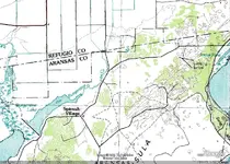
Here's the USGS topo map showing Burgentine Creek and interestingly enough a place marker called 'Spanish Village' nearby. If you Google 'Burgentine Creek' you will quickly find information that links this creek to the legend of the Barkentine that was marooned on the nearby plains after a hurricane. If you opened up my .KML file in Google Earth that I posted up above, this shot is right around marker number 2.

burgentine.jpg

Also, if you guys haven't done so already, you can use this Topographical Map overlay for Google Earth...it works very well but you do get a slight delay while it loads the map for whatever area you're in.

http://www.gearthblog.com/kmfiles/topomaps.kmz

Pcola
 

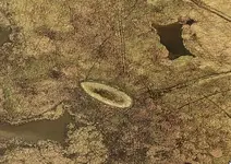
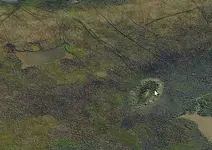
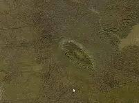
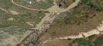
LOL...I have found the remains of a large ship...it certainly falls within the shape and length of what I would have expected. The outline is fairly noticeable in Google Earth but take a look at the VirtualEarth bird's eye shots. Here's the coordinates along with a screen shots from VirtualEarth.

28°15'34.93"N 96°56'15.79"W

Find it with Google Earth first to get familiar with the surrounding terrain then go to www.virtualearth.com to the same area then click on Bird's Eye. Pretty convincing to me but who knows.

barkN.jpg
North at top

barkE.jpg
East at top

BarkS.jpg
South at top

barkW.jpg
West at top

This is most definitely the remains of a sailing ship and possibly even the one we're looking for. Notice the bulge in the center of the outline. I'd be willing to bet that's either the ballast pile or the center board box (assuming it was equipped with a center board). According to Google Earth the outline is approximately 160' in length and 26' abeam. This location is further to the wsw than the topo map I posted above.

Exciting stuff.

Pcola
 

Heres another boat wreck i found,just a little north east of your possible boat.
 

Attachments

  • boat.jpg
    boat.jpg
    57 KB · Views: 2,326
Pcola,

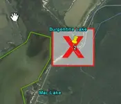
Did google just lock anyone from going to this area?Check out the big red box and X that just showed up on my google.
 

Attachments

  • googleblockedred.jpg
    googleblockedred.jpg
    21.2 KB · Views: 1,980
FISHEYE said:
Pcola,

Did google just lock anyone from going to this area?Check out the big red box and X that just showed up on my google.

That usually only comes up if there is not a super detailed topo image for that particular location...you should be able to either change your zoom-in or scroll around a bit and wait until the image loads.

Pcola
 

Top Member Reactions

Users who are viewing this thread

Back
Top