Trail Signs and Monuments-Spanish or Somebody Else

On one of my trips to visit with my Dad , (given enough time) I will try to drive some of the two roads, “Butterfield Trail “ and The Old Wire road.

They run very close to one another, and if my memory is correct,.... I think that they cross paths.

It has been a while since I’ve been to them both but I think that some photos and GPS plotting trails, might just help.

I won’t know if I don’t try!!

#/;0{>~
 

That was a great post, RC. I've read that loads of copper culture artifacts have been found along the Rock River in Wisconsin and Illinois. In Wisconsin, there is a Mound Builder settlement called Aztalan real close to the Rock River. The Rock River flows into the Mississippi River at Rock Island, Illinois. I have read about a copper cache site found close to the Mississippi, that seemed to be packed to travel.

Poverty Point is a real interesting place and the mounds are set up in semi-circles, if I remember right. I never heard of the Natchitoches Trace until the other day, but it is really interesting to me. I'm gonna have to give it a closer look.

Natchitoches had an alleged trail (sorry , the geography is out of my wheelhouse) that led to Tenochtitlan.

Trails and trade routes from copper country to present day Mexico City so far just tracing copper. No reason to not expect them to continue from there....

And what went North as an exchange of copper?:dontknow:
 

For those interested in copper's USA history, here's an interesting monthly newsletter you can have emailed to you:

Monette Bebow-Reinhard
2725 N Butlin Dr
Beloit WI 53511
(920) 639-5842

www.
ArtifactsandStories. com
[email protected]

Donate your copper data
 

Natchitoches had an alleged trail (sorry , the geography is out of my wheelhouse) that led to Tenochtitlan.

Trails and trade routes from copper country to present day Mexico City so far just tracing copper. No reason to not expect them to continue from there....

And what went North as an exchange of copper?:dontknow:

Yeah. I was wondering about that what goes north question myself. What do you think about this.

https://en.wikipedia.org/wiki/Tumbaga

This might be why the Mexican civilizations needed almost pure copper from Lake Superior. If they were melting copper with gold, it would probably be to their advantage to have the purest metals they could find. But what were they trading in return. You mentioned a relay system, probably from one important village to another, along a trade route from Lake Superior to Mexico. The copper could have moved south to Cahokia, which was an important religious center. It was also a place where copper ornaments were made. Maybe raw copper moved even closer to Mexico from Cahokia, from village to village, like that relay system you mentioned. The Mexicans probably didn't even have to travel that far from Mexico, if at all. So what did they send back north? Maybe nothing. Except for the occasional gulf coast shell, there don't seem to be many items from Mexico, in the upper Mississippi River region. Maybe the copper would have been some type of tribute sent to the Mexican civilizations or some type of cooperation between people that share similar religious beliefs. The tumbaga was used to make religious objects. Just tossing some thoughts out there hoping for some archeological evidence.

Something else that I have wondered about, is why did the Copper Culture stop making tools. They stopped making tools about 3000 years ago and concentrated on ornamental objects. Doesn't make sense.

One theory is social stratification being an beginning towards the end of copper culture. Or better put (?) ...The dawn of late archaic into woodland period/people.

From the North (if a midwestern resident) came furs and meats at times for barter. South had maize beans and squash. Plus foraged stuff. Maple sugar and so forth.
Does not seem they would be interested in hauling corn from pre-Mexico when they could grow or trade locally for it.
Climate during glacial periods could factor if it was that long ago ,but copper mining/acquiring was estimated to be 500 years after last glacial retreat. Drought ,famine ,volcanic activity have all caused concerns through history..Then hauling would be worth it. (History here notes 1816 as the year without a summer due to climate disruption from a volcano. We don't have much record of earlier events ,though glacial core samples show fluctuations and climate changes over time.)

Tenochtitlan was a hub of sorts. A network extended from it , of trade.
[A thriving culture developed, and the Mexica civilization came to dominate other tribes around Mexico. The small natural island was perpetually enlarged as Tenochtitlan grew to become the largest and most powerful city in Mesoamerica. Commercial routes were developed that brought goods from places as far as the Gulf of Mexico, the Pacific Ocean and perhaps even the Inca Empire.]

If recalled correctly , ( now there's a gamble) those who began to make the site of Tenochtitlan a place to live were on the in betweens or low on the totem pole as far as status /power/ dominance in the region. They became a force though. Especially in trade.

Not knowing pre Mexico history of trade goods , I can only guess from not noting much mention of relics from there turning up in the midwest.
With exceptions only briefly read and not peer reviewed that I recall.

The lack of information regarding goods going North , combined with no evidence of habitation in the copper range teases me with the idea that those who worked the mines ,(or better yet those who distributed copper) came with tools and food to support their labor/enterprise , and left with copper.
Or...to run with your mention of smelting/working metal in the South ...Trading raw copper for a more shiny, more durable ,less polishing or turning your skin green ornaments could have been worthwhile. But evidence should exist in mounds or other sites if that happened. The more portable a good on long journys , the more it appeals.

I've lost track of the early explorer that noted decorative (?) copper axes in the pre-Mexico region , but that does not mean it was Michigan copper they were made from. It can be identified if tested by the right process. (Would be interesting if such a relic was sorted out...)
As can other precious metals pre smelting stage. Gold ores are an example , with some recognizable even to specific mines.
Arizona mines copper "dust". Add water and let it settle out. At least one mine there uses/used copper from Michigan to show copper samples. (Better than dust!)
 

Last edited:
Yeah. I was wondering about that what goes north question myself. What do you think about this.

https://en.wikipedia.org/wiki/Tumbaga

This might be why the Mexican civilizations needed almost pure copper from Lake Superior. If they were melting copper with gold, it would probably be to their advantage to have the purest metals they could find. But what were they trading in return. You mentioned a relay system, probably from one important village to another, along a trade route from Lake Superior to Mexico. The copper could have moved south to Cahokia, which was an important religious center. It was also a place where copper ornaments were made. Maybe raw copper moved even closer to Mexico from Cahokia, from village to village, like that relay system you mentioned. The Mexicans probably didn't even have to travel that far from Mexico, if at all. So what did they send back north? Maybe nothing. Except for the occasional gulf coast shell, there don't seem to be many items from Mexico, in the upper Mississippi River region. Maybe the copper would have been some type of tribute sent to the Mexican civilizations or some type of cooperation between people that share similar religious beliefs. The tumbaga was used to make religious objects. Just tossing some thoughts out there hoping for some archeological evidence.

Something else that I have wondered about, is why did the Copper Culture stop making tools. They stopped making tools about 3000 years ago and concentrated on ornamental objects. Doesn't make sense.

The Mexica and/or other Mesoamericans may have been aware of the native copper deposits at Santa Rita NM. The pure metal was growing out of the ground like ferns over an extensive area. The Cabeza de Vaca party reported Native Tribal use of the metal when they passed through southern NM in the 1530s, and despite overwhelming Apache trouble, the Spanish began harvesting the native metal and rich oxide ores sometime in the 1700s. Cliff dwelling artifacts and Mesoamerican petroglyphs found in southern NM indicate trade contacts, but the extent of it is uncertain.

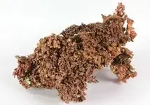
copper.jpeg
 

Last edited:
Unlike the five posters whom I have placed on permanent IGNORE here, I enjoy your posts, cyzak. Those guys can be tighter than a clam with lockjaw at times, but you - I wish you the best of luck with your project this year.

After some thought into my actions I have deleted the post please accept my apologizes.
 

The late archaic -into woodland period was a time of the red ocher people. Copper was among their burials too.
Glacial kame burials differed from mounds elsewhere of natural hills /high spots. And differed from woodland and Mississippian earth mounds built by lugging soil.
They seem to be among the latter or last pre contact groups , and had copper in possession still..

But back tooriginal topic., maybe.

Marking a site or directional marker in the region of copper would have been most expedient by making a simple cairn.
Tools were left .large stone hammers ect. likely in exchange for cargo weight allowance for copper.
Isle Royal had copper extraction too so watercraft had to factor for a party working there. Waiting for ice and consideration of climate in winter suggests it was a summer endeavor.

Wagon loads of stone tools were hauled out of pits.
A cairn would be just as convenient to toss in the wagon for fill material.

Here is an interesting native known and used landmark removed in later times. https://en.wikipedia.org/wiki/Ontonagon_Boulder
 

I'd sure like to have a copy of this book - about $80 used. Here's their website. Fortunately, if you click on "Sample Chapter", you get a great read (and 3-page bibliography) on ancient Michigan copper being linked to the Mediterranean. Of note on page 2 is the statement, "[FONT=&quot]It is thought that most of the miners retired to [/FONT][FONT=&quot]Aztalan[/FONT][FONT=&quot] (near Madison, Wisconsin) and other locations to the south at the onset of the hard winters on Lake Superior".

Rocks & Rows - Sailing Routes Across The Atlantic And The Copper Trade - Jay Stuart Wakefield & Reinoud M. De Jonge

[/FONT]
[FONT=&quot]


[/FONT]
 

I'd sure like to have a copy of this book - about $80 used. Here's their website. Fortunately, if you click on "Sample Chapter", you get a great read (and 3-page bibliography) on ancient Michigan copper being linked to the Mediterranean. Of note on page 2 is the statement, "[FONT="][SIZE=3]It is thought that most of the miners retired to [/SIZE][/FONT][/COLOR][COLOR=#ff0000][FONT="]Aztalan[/FONT][FONT="][SIZE=3] (near Madison, Wisconsin) and other locations to the south at the onset of the hard winters on Lake Superior".

[url=http://www.rocksandrows.com/index.php]Rocks & Rows - Sailing Routes Across The Atlantic And The Copper Trade - Jay Stuart Wakefield & Reinoud M. De Jonge[/url]

[/SIZE][/FONT][/COLOR][COLOR=#505050][FONT="]


[/FONT]

Details of the monuments would be spot on on this thread....

A decade or more ago when trying to sort out the early goins on here , there was found greater speculation than mine (a shocker , I know) about the who's.
A particular "group think" was rejected due to there not really being any accepting peers beyond the small group.
How much they originated vs retold seemed a jumble of all theories with selected focus on some more than others. Not a bad thing. But nothing came of it as far as confirmation or evidence pursued.

I'm naturally skeptical , but also a former voracious reader of things related to early history and natives here.
It gets jumbled but always nice to see other sources with similar accounts. More so at a greater distance than just this locale.....

So , thanks for your patience folks.
 

The late archaic -into woodland period was a time of the red ocher people. Copper was among their burials too.
Glacial kame burials differed from mounds elsewhere of natural hills /high spots. And differed from woodland and Mississippian earth mounds built by lugging soil.
They seem to be among the latter or last pre contact groups , and had copper in possession still..

But back tooriginal topic., maybe.

Marking a site or directional marker in the region of copper would have been most expedient by making a simple cairn.
Tools were left .large stone hammers ect. likely in exchange for cargo weight allowance for copper.
Isle Royal had copper extraction too so watercraft had to factor for a party working there. Waiting for ice and consideration of climate in winter suggests it was a summer endeavor.

Wagon loads of stone tools were hauled out of pits.
A cairn would be just as convenient to toss in the wagon for fill material.

Here is an interesting native known and used landmark removed in later times. https://en.wikipedia.org/wiki/Ontonagon_Boulder

Thanks for the link RC. Seems strange that the federals would be so interested in the rock. Probably under some pressure from the Smithsonian.
 

I'd sure like to have a copy of this book - about $80 used. Here's their website. Fortunately, if you click on "Sample Chapter", you get a great read (and 3-page bibliography) on ancient Michigan copper being linked to the Mediterranean. Of note on page 2 is the statement, "It is thought that most of the miners retired to Aztalan (near Madison, Wisconsin) and other locations to the south at the onset of the hard winters on Lake Superior".

Rocks & Rows - Sailing Routes Across The Atlantic And The Copper Trade - Jay Stuart Wakefield & Reinoud M. De Jonge


That was a real good link, Sdc. Thank you.

I've heard about the shipwreck by Turkey, but I didn't know there was so much copper and tin.
 

In addition to sdcfia 's mention of extraction from ore , arrastra's were used in other areas early on. In the S.W. for sure.

Thanks for the excellent link, releventchair.
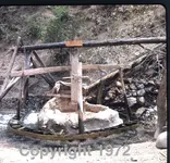
Here is a water driven arrastra in operation which I encountered on a walk down the Sierra Madre near Chinipas, then Sonora, now Sinaloa. I stumbled into the gold camp from their blindside causing excitement and firearms to be drawn. After a few calming words I was given a tour of the operation and sent on my way after promising not to reveal their location. Not a real problem because my maps, the best available, were 1953 German maps with 200 meter elevation lines and the river I was following ran the opposite direction the map said........Not lost, just no idea where I was. With their directions I was in Chinipas three days later.
WH

mex74025-cleaned.jpeg
 

Natchitoches had an alleged trail (sorry , the geography is out of my wheelhouse) that led to Tenochtitlan.

Trails and trade routes from copper country to present day Mexico City so far just tracing copper. No reason to not expect them to continue from there....

And what went North as an exchange of copper?:dontknow:

Here's a link that asks the what went north question. It's a real good link about Poverty Point trade.

https://www.crt.state.la.us/dataprojects/archaeology/virtualbooks/poverpoi/trade.htm

The mounds at Poverty Point were built between 1700 and 1100 BC. Copper artifacts, from the Copper Culture of the western Great Lakes, have been dated from 4000 to 1000 BC. So the copper mining was still active at the time that Poverty Point was occupied. So there was either some interaction between the Great Lakes copper miners and the citizens of Poverty Point, or the people of Poverty Point did their own copper mining. Also, no stone artifacts from Poverty Point have been found close to the copper mines, so nothing went north.

The Poverty Point trade doesn't explain all the copper that has been removed from the Great Lakes region during ancient times. The Bronze Age in Europe lasted from 3300 to 1200 BC. and this would correspond with the activity in the copper mines and Poverty Point. But, there is no evidence of trade items from Europe or the Near East in the copper producing regions of the western Great Lakes. So, it seems like whoever was taking copper from the Great Lakes, wasn't bringing anything to trade. For that much copper, you would think, at the very least, there would be a lot of trade beads, up north. Here's a link that shows Phoenician trade beads. Some are reproductions.

https://www.google.com/search?q=bea...gAhUpq4MKHbC5DO44HhD8BQgOKAE&biw=1366&bih=657

Here are beads from Poverty Point.

https://www.google.com/search?rlz=1...gAhXI7oMKHRMxCnwQsAR6BAgEEAE&biw=1366&bih=657

Any thoughts.

Always thoughts.....L.o.l..

Pre Euro contact trade of beads would be native manufactured. Copper culture waned pre-contact/early contact.

Beads traded for could have gone to /stayed home with "mama". Or simply not been lost often during the brief season of copper harvest. Add time to a stone bead /beads lost and it would take a good squint to find one maybe.

There was an account, (I need to get a card and haunt libraries again) of a culture(Ottawa?) that cleaned and saved the bones of deceased members. For years until a ceremony occurred at intervals when mass internment was done.
Elaborate function.
Furs/blankets lined pit. Gifts were added.
I've not read or heard of such a site unearthed. Special (non common/local) beads could have gone there. Hard tellin.

Did the Poverty point area deal in slaves? Or laborers? They would not have left evidence different that those mining copper.
 

This article does not mean trade for sure. But does have copper traveling S.E..
https://www.binghamton.edu/news/sto...-native-americans-engaged-in-trade-more-exten

Tobacco would not leave much evidence if a trade item. Shells we know got around too.

[ Early Patterns. Archaeological evidence suggests strongly that Native Americans living in the Northeast traded with each other and with Indians from other regions as early as 2000 b.c. Copper artifacts found at sites in New York and Ontario, for example, were likely acquired through trade with Indians living in the copper-rich upper Great Lakes region. Archaeological evidence also indicates that Middle Woodland-era Indians living in the Northeast traded with the Hopewell culture that dominated the central Mississippi, Ohio, and Illinois River valleys from 300 b.c. to 250 a.d. From these Mound Builders the northeastern Indians obtained luxury goods such as large sea shells that originated in the Gulf of Mexico, pottery figures, pearls, and copper and silver ornaments. Through this trade the northeastern Indians also acquired the Hopewell culture’s highly developed pottery styles and agricultural techniques.]
(https://www.encyclopedia.com/history/news-wires-white-papers-and-books/indigenous-trade-northeast)
 

Last edited:
I'd sure like to have a copy of this book - about $80 used. Here's their website. Fortunately, if you click on "Sample Chapter", you get a great read (and 3-page bibliography) on ancient Michigan copper being linked to the Mediterranean. Of note on page 2 is the statement, "[FONT="][SIZE=3]It is thought that most of the miners retired to [/SIZE][/FONT][/COLOR][COLOR=#ff0000][FONT="]Aztalan[/FONT][FONT="][SIZE=3] (near Madison, Wisconsin) and other locations to the south at the onset of the hard winters on Lake Superior".

[url=http://www.rocksandrows.com/index.php]Rocks & Rows - Sailing Routes Across The Atlantic And The Copper Trade - Jay Stuart Wakefield & Reinoud M. De Jonge[/url]

[/SIZE][/FONT][/COLOR][COLOR=#505050][FONT="]


[/FONT]

Have you ever looked at any of the Lewis Cass records? Especially his expidition in Michigan to find copper?
 

Last edited:
The Tnet members who follow this forum, have an obvious interest in the signs and monuments that lead to treasure vaults. Three threads illustrate this interest.

http://www.treasurenet.com/forums/treasure-marks-signs/78421-basic-signs-symbols-you-have-found.html

This is Old Dog's thread. He started it in 2008 and it has had more than 625,000 views. Old Dog writes about Spanish sign.

http://www.treasurenet.com/forums/treasure-marks-signs/129235-treasure-signs-symbols-101-a.html

Rangler started this thread in 2009 and it has had over 337,000 views. A lot of information he posts, comes from another Tnet poster called Stilldign. Stilldign believed that the vault sites were set up by a secret society that has existed for centuries, and still exists. He has written that this secret society has created vault sites, all over the world, using identical signs and monuments.

Here is a more recent thread, started in 2016 by Sandy1. So far, Sandy's thread has had over 335,000 views. Sandy gives most of his observations in his first post, which makes it very easy to go back and look for information. He writes about Spanish and Church vault sites.

http://www.treasurenet.com/forums/t...5-guide-vault-treasure-hunting-condensed.html

I believe they are all excellent threads and they describe many of the same signs and monuments.

Because there is little or no historic documentation about monuments and symbols that lead to vaults, there has been a lot of debate about the material in these threads, some of it very heated.

I call the sites they describe, owl, heart, triangle sites. These items are common to their trails and vault sites. I've seen all three at the one site I've studied, over the past ten years. These signs and symbols have been pretty much beat to death so I don't plan on spending much time offering new information, because I don't have any. But, if anybody wants to talk about these symbols and monuments, please post your comments and pictures, if you like. These places exist, but instead of trying to explain the signs and symbols, I would like to find out where to look for them. I would also like to find evidence of when they were constructed and who they belonged to. I'll post a lot of random information, in the hopes that somebody will find something that grabs their interest and leads them to further research. I hope that our posters will share their research with the rest of us.
 

Top Member Reactions

Users who are viewing this thread

Back
Top