You are using an out of date browser. It may not display this or other websites correctly.
You should upgrade or use an alternative browser.
You should upgrade or use an alternative browser.
The Treasure of Captain William Kidd.
- Thread starter Randawg72
- Start date


Bocaj
Full Member
- Joined
- Dec 4, 2024
- Messages
- 106
- Reaction score
- 29
- Golden Thread
- 0
- Detector(s) used
- Left and right side of the brain
Source of this information?Supposedly when Captain Kidd was in jail awaiting trial, he slipped a small note to his wife Sarah with the numbers "44106818" written on it. Some think that these numbers are a clue to the location of Kidd's hidden treasure.
Are they a secret code, or coordinates (some think it's Deer Island), or do these numbers have some other meaning? Or do you think (like me) that the story of the coded note is just a made up myth?
View attachment 2194751
Randawg72
Full Member
- Joined
- Nov 18, 2024
- Messages
- 235
- Reaction score
- 232
- Golden Thread
- 0
- Detector(s) used
- ACME Bottlecap 6000
- #304
Thread Owner
Hi Bocaj,
It's referenced in many places including on this website. (Google "Captain Kidd 44106818").
The pic that I swiped is from America Unearthed, S3, E6. "Captain Kidd's Pirate Code".
It's referenced in many places including on this website. (Google "Captain Kidd 44106818").
The pic that I swiped is from America Unearthed, S3, E6. "Captain Kidd's Pirate Code".
Bocaj
Full Member
- Joined
- Dec 4, 2024
- Messages
- 106
- Reaction score
- 29
- Golden Thread
- 0
- Detector(s) used
- Left and right side of the brain
Deer island coordinates, Certainly done much later as Kidd would have used a different zero meridian than the modern Greenwich.Hi Bocaj,
It's referenced in many places including on this website. (Google "Captain Kidd 44106818").
The pic that I swiped is from America Unearthed, S3, E6. "Captain Kidd's Pirate Code".
Centuries of all kind of myths, hoax and books have muddied the real story so much that anyone trying to find the truth has to walk very carefully and its better to stay away from rather murky claims like that number.
Randawg72
Full Member
- Joined
- Nov 18, 2024
- Messages
- 235
- Reaction score
- 232
- Golden Thread
- 0
- Detector(s) used
- ACME Bottlecap 6000
- #306
Thread Owner
Deer island coordinates, Certainly done much later as Kidd would have used a different zero meridian than the modern Greenwich.
What meridian do you think Kidd used? The Royal Observatory at Greenwich was established in 1675, and has been the official prime meridian in the UK since 1721.
Bocaj
Full Member
- Joined
- Dec 4, 2024
- Messages
- 106
- Reaction score
- 29
- Golden Thread
- 0
- Detector(s) used
- Left and right side of the brain
Certainly not Greenwich, most probably Tenerife, Canary Islands. In any case it depends more on what nautical chart he used. So for different places he could have used different prime meridians. It was quite a chaos those days and as I said it was rather depended on the charts he acquired then on his own preferences.What meridian do you think Kidd used? The Royal Observatory at Greenwich was established in 1675, and has been the official prime meridian in the UK since 1721.
All longitudes from those days are to be taken with a lot of caution. Latitudes to a lesser degree as they have always been fixed to the equator (axis of earth rotation) and that doesn't change. When close or on land coordinates are most probably measured relative to the used charts and can be quite off depending how old and good the chart he used was. Also those days most charts used 0-360deg all to E, not 0-180deg E or W!
There is lot more to study of the old days navigation until even getting a vague idea how different the world appeared tin the 17th century to what it is now. Frankly its not just study from books but sailing and navigating like them. Then maybe there is a chance to discover the truth of Kidd's treasure.
Randawg72
Full Member
- Joined
- Nov 18, 2024
- Messages
- 235
- Reaction score
- 232
- Golden Thread
- 0
- Detector(s) used
- ACME Bottlecap 6000
- #308
Thread Owner
Certainly not Greenwich, most probably Tenerife, Canary Islands. In any case it depends more on what nautical chart he used.
Hi Bocaj,
So you think that Captain Kidd, a Scottish born son of the British isles, and loyal to king William III, would have used the "El Hierro" (Canary Island) meridian selected by king Louis XIII of France (which was replaced by the Paris meridian in 1666 by Louis XIV). A country that was almost constantly at war with the Kingdom of England?
I'm sorry but I seriously doubt that. Regardless of the chart being used.
Bocaj
Full Member
- Joined
- Dec 4, 2024
- Messages
- 106
- Reaction score
- 29
- Golden Thread
- 0
- Detector(s) used
- Left and right side of the brain
I didn't write 'El Hierro' but 'Tenerife' which was used by the Dutch for a long time. Also Canary Islands or 'The Fortunate Islands' as they were called in the antique where the west most known part of the world since than before the discovery of the Azores and Cape Verde Islands and later The Americas. The islands did part the world in the 'Old'/East and 'New'/West spheres of the world. In any case even for English sailors (most I remember would use dutch charts anyway) they would have used the Lizard and not Greenwich at the time anyway.Hi Bocaj,
So you think that Captain Kidd, a Scottish born son of the British isles, and loyal to king William III, would have used the "El Hierro" (Canary Island) meridian selected by king Louis XIII of France (which was replaced by the Paris meridian in 1666 by Louis XIV). A country that was almost constantly at war with the Kingdom of England?
I'm sorry but I seriously doubt that. Regardless of the chart being used.
In any case the Tenerife meridian has absolute nothing to do with France!
BennyV
Bronze Member
- Joined
- Feb 22, 2021
- Messages
- 1,228
- Reaction score
- 2,055
- Golden Thread
- 0
- Primary Interest:
- All Treasure Hunting
I’ve been following this thread for quite some time. I am kind of skeptical about him burying stuff halfway around the world.
These maps and codes just don’t make sense to me.
From Cape May, NJ to Rhode Island there are literally thousands, if not tens of thousands, of islands, coves, and points that are easily accessible from NY Harbor or up the Hudson River. Any & all of these places would be better hiding spots, especially if he was trying to get Lord Bellomont to protect him. He’d want to have the loot relatively close to home (tops 1-3 days sailing time) in case he needed to make a payoff or split quickly. I believe in the former rather than the latter, he didn’t think he did anything wrong, so no need to split. He was in the upper class of NYC society at the time.
Just my 2 cents.
Bocaj
Full Member
- Joined
- Dec 4, 2024
- Messages
- 106
- Reaction score
- 29
- Golden Thread
- 0
- Detector(s) used
- Left and right side of the brain
I can agree with you assuming we really speak about Kidd's treasure. But for me it seems more reasonable to assume that the treasure the maps and later letters mention is not his but only came to his knowledge from some other source (Avery most likely). So most likely he never had that treasure on board but simply visited the place it has been buried by someone else. He could hardly amassed that fortune all by himself. The crew he was sailing on both Adventure Galley and the renamed QM was very suspicious of him and it would have been impossible to bury it without their knowledge and agreement.I’ve been following this thread for quite some time. I am kind of skeptical about him burying stuff halfway around the world.
These maps and codes just don’t make sense to me.
From Cape May, NJ to Rhode Island there are literally thousands, if not tens of thousands, of islands, coves, and points that are easily accessible from NY Harbor or up the Hudson River. Any & all of these places would be better hiding spots, especially if he was trying to get Lord Bellomont to protect him. He’d want to have the loot relatively close to home (tops 1-3 days sailing time) in case he needed to make a payoff or split quickly. I believe in the former rather than the latter, he didn’t think he did anything wrong, so no need to split. He was in the upper class of NYC society at the time.
Just my 2 cents.
I always thought that Kidd's story doesn't make sense until I run across the 'Avery the Pirate' letter here on the forum. Avery would have a much higher motivation to bury the treasure further away as he was a wanted pirate without much of the protection Kidd had assumed to get with his upper-class NY friends.
BennyV
Bronze Member
- Joined
- Feb 22, 2021
- Messages
- 1,228
- Reaction score
- 2,055
- Golden Thread
- 0
- Primary Interest:
- All Treasure Hunting
Valid points. But you must remember. Kidd’s crew tried to mutiny not once, but twice. Perhaps he hid what contraband was stashed away in the QM captain’s cabin without anyone getting wise to it.I can agree with you assuming we really speak about Kidd's treasure. But for me it seems more reasonable to assume that the treasure the maps and later letters mention is not his but only came to his knowledge from some other source (Avery most likely). So most likely he never had that treasure on board but simply visited the place it has been buried by someone else. He could hardly amassed that fortune all by himself. The crew he was sailing on both Adventure Galley and the renamed QM was very suspicious of him and it would have been impossible to bury it without their knowledge and agreement.
I always thought that Kidd's story doesn't make sense until I run across the 'Avery the Pirate' letter here on the forum. Avery would have a much higher motivation to bury the treasure further away as he was a wanted pirate without much of the protection Kidd had assumed to get with his upper-class NY friends.
Why would he lie? He had no chance of escape even if they let him go dig it up.
markmar
Silver Member
- Joined
- Oct 17, 2012
- Messages
- 4,300
- Reaction score
- 6,532
- Golden Thread
- 0
- Primary Interest:
- All Treasure Hunting
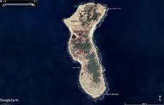
IMO, if the numbers 44106818 would be for degrees of latitude and longitude, then the only island which match 44*10' lat and 68*18' long is the Great Duck Island of Mein. It has a lagoon on the west side.
What is your opinion?
What is your opinion?
markmar
Silver Member
- Joined
- Oct 17, 2012
- Messages
- 4,300
- Reaction score
- 6,532
- Golden Thread
- 0
- Primary Interest:
- All Treasure Hunting
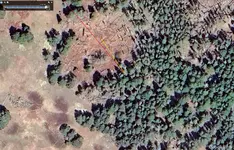
Now let's do the math on what is written on one of the maps. IMHO, the most convenient spot to start a survey for this treasure, would be a specific stone (marked) on the west shore at the south end of the lagoon. From there we have to measure 515 yards SE and by 50* north (red line), which means 515 yards in a 140 degrees SW. Seems at the end of this measurement, there is a tree which would been marked somehow.
Now, from the tree we have to measure 36 yards NE (yellow line), which means we go by 45 degrees to the NE. Seems at the end of this measurement, there is a strange round shape with a sort of pile in the middle.
Also, the "ten turtles" clue from the map, could be rock shapes on the east shore of the island.
Good luck to those who will try to do this research, of course if they will be believe in this new info.
Attachments
Last edited:
Randawg72
Full Member
- Joined
- Nov 18, 2024
- Messages
- 235
- Reaction score
- 232
- Golden Thread
- 0
- Detector(s) used
- ACME Bottlecap 6000
- #315
Thread Owner
I didn't write 'El Hierro' but 'Tenerife' which was used by the Dutch for a long time. Also Canary Islands or 'The Fortunate Islands' as they were called in the antique where the west most known part of the world since than before the discovery of the Azores and Cape Verde Islands and later The Americas. The islands did part the world in the 'Old'/East and 'New'/West spheres of the world. In any case even for English sailors (most I remember would use dutch charts anyway) they would have used the Lizard and not Greenwich at the time anyway.
In any case the Tenerife meridian has absolute nothing to do with France!
Tenerife was favored by the Dutch cause it has a big volcano on it as a landmark (Mount Teide}. But the same logic applies. Why would Kidd use someone else's meridian when his home country had already designated a perfectly good one? (And it's still in use today).
(PS: England also fought with Spain and the Netherlands, but had a longtime feud with their nemesis France. No self respecting Brit would ever use the meridian chosen by a French king.
Also, El Hierro is the farthest south and west of all the Canaries).
markmar
Silver Member
- Joined
- Oct 17, 2012
- Messages
- 4,300
- Reaction score
- 6,532
- Golden Thread
- 0
- Primary Interest:
- All Treasure Hunting
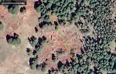
I want to add something very important IMO. On the map the "36 NE" is written twice. This prompt to a second cache near the first I have mentioned above, but because is under the words " 50 N " we have to go 5 degrees to the north from the marked tree. So, we have to go 72 yards 40 degres NE by N from the marked tree (green line). Seems there is a weird structure at the end of this third measurement.Now let's do the math on what is written on one of the maps. IMHO, the most convenient spot to start a survey for this treasure, would be a specific stone (marked) on the west shore at the south end of the lagoon. From there we have to measure 515 yards SE and by 50* north (red line), which means 515 yards in a 140 degrees SW. Seems at the end of this measurement, there is a tree which would been marked somehow.
Now, from the tree we have to measure 36 yards NE (yellow line), which means we go by 45 degrees to the NE. Seems at the end of this measurement, there is a strange round shape with a sort of pile in the middle.
Also, the "ten turtles" clue from the map, could be rock shapes on the east shore of the island.
Good luck to those who will try to do this research, of course if they will be believe in this new info.
Definitely, we have three directions with 5 degrees angle between each other from the marked tree, with the two directions for the caches to be reflections of the direction which is coming to the marked tree from the starting point.
Attachments
Last edited:
Bocaj
Full Member
- Joined
- Dec 4, 2024
- Messages
- 106
- Reaction score
- 29
- Golden Thread
- 0
- Detector(s) used
- Left and right side of the brain
To repeat myself: Greenwich wasn't used as meridian before 1721, in English navigators used mostly Dutch charts because the Dutch were the best chart makers at the time. Not so much different these times - People buy the stuff that suits them best mostly independent of the countries they come from - more so sailors who are more at home at sea than to be loyal to any nation!Why would Kidd use someone else's meridian when his home country had already designated a perfectly good one? (And it's still in use today).
Hierro is not Tenerife and was chosen by the French bc Hierro is 20deg west of their Paris meridian which suited them better then Tenerife.(PS: England also fought with Spain and the Netherlands, but had a longtime feud with their nemesis France. No self respecting Brit would ever use the meridian chosen by a French king.
You can of course continue ignoring unpleasant facts that do not fit you favorite island. Longitude was certainly not Greenwich in the 17th century and if the skeleton chart coordinates point to a fitting island than it is certain it was not original but drawn much later and certainly not by W.K.!
Bocaj
Full Member
- Joined
- Dec 4, 2024
- Messages
- 106
- Reaction score
- 29
- Golden Thread
- 0
- Detector(s) used
- Left and right side of the brain
These sound like typical sailing routes not anything that you would use on land. To spell it more clearly: sail 515 SE then turn (at some cape or other clearly visible landmark) turn port and continue 50 N (probably entering some bay) from their continue more to starboard 36 NE at some other landmark or reef turn in direction of some visible stones and continue some more 36 NE. When i comes to length units we can only guess: it could be cables or yards but also (nautical?) miles or any of the other length units used at the time.I want to add something very important IMO. On the map the "36 NE" is written twice. This prompt to a second cache near the first I have mentioned above, but because is under the words " 50 N " we have to go 5 degrees to the north from the marked tree. So, we have to go 72 yards 40 degres NE by N from the marked tree (green line). Seems there is a weird structure at the end of this third measurement.
In any case your island is at the wrong position anyway bc as mentioned above Greenwich wasn't in use at the time. Apart from almost al the rest of features missing.
49er12
Bronze Member
- Joined
- Aug 22, 2013
- Messages
- 1,301
- Reaction score
- 1,702
- Golden Thread
- 0
- Location
- Rolling Rock, Pennsylvania
- Detector(s) used
- Minelab xterra, Whites DFX, Notka Makro Simplex. Folks the price don’t mean everything, the question is are you willing to put in the time to learn the machine, experience will pay off I guarantee it.
- Primary Interest:
- All Treasure Hunting
Nice story, look my point is to find out the exact truth of locations of these sunken vessels, google earth will show what, to be honest the only people that have the ability to search for these ships is either government with satellites that penetrate the waters to depth, and or have the financial means to search with expensive and sophisticated equipment, most of us can’t. SO WE CAN ONLY FIND WHAT WASHES ASHORE IN REALITY. What your thoughts on regular folks recovering such items thankyou
markmar
Silver Member
- Joined
- Oct 17, 2012
- Messages
- 4,300
- Reaction score
- 6,532
- Golden Thread
- 0
- Primary Interest:
- All Treasure Hunting
To me the measurements look like are written on the island. Also the measurement on feet doesn't promt to a measurement on the water. But everybody are free to believe in their theory, if there exists one.These sound like typical sailing routes not anything that you would use on land. To spell it more clearly: sail 515 SE then turn (at some cape or other clearly visible landmark) turn port and continue 50 N (probably entering some bay) from their continue more to starboard 36 NE at some other landmark or reef turn in direction of some visible stones and continue some more 36 NE. When i comes to length units we can only guess: it could be cables or yards but also (nautical?) miles or any of the other length units used at the time.
In any case your island is at the wrong position anyway bc as mentioned above Greenwich wasn't in use at the time. Apart from almost al the rest of features missing.
My opinion is Kidd never was in the China Sea. The better he would have had to do, was to make maps to deceive future treasure lovers who would want his treasure. The coords he gave on the maps were for nowhere. An imaginable island which would has few identical datails with the real deal.
Good luck in roaming the oceans for the ghost island. More quickly someone will find Atlantis.
Top Member Reactions
-
 2258
2258 -
 1503
1503 -
 1316
1316 -
 1286
1286 -
 1053
1053 -
 963
963 -
 818
818 -
 653
653 -
 629
629 -
 535
535 -
 528
528 -
 503
503 -
 503
503 -
 475
475 -
 454
454
Similar threads
- Replies
- 0
- Views
- 76
- Replies
- 2
- Views
- 709
Users who are viewing this thread
Total: 1 (members: 0, guests: 1)

Latest Discussions
-

-

-
 Garrett Vortex VX9 potential major flaw(s) with latest version software
- Latest: tnsharpshooter
-
-
