The history of Tayopa

Hola amigo,
I found a bit more concerning that accusation of a plot to betray the island of Chiloe to the English, in an English book that dates to 1746;

http://books.google.com/books?id=6r...By Thomas Salmon&pg=PA372#v=onepage&q&f=false

...apparently the English were openly toying with the idea, and this book was published circa 1746, same year two Dutch ships surreptitiously landed on the west coast of New Spain. Purely coincidence I suppose. Perhaps a thorough research of this plot would turn up very 'dammin' evidence indeed. :o
Roy

Postscript; I wonder if there are any interesting documents on Tayopa in the Dutch archives?
 

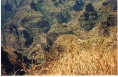
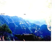
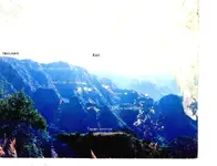
Allo peeps, Oro de Tayopa: Perhaps you can appreciate why Tayopa has been hidden for almost 400 years, even after entering the area.

Incidentally, the two infamous 'cerros Chapos' are at the left center of the picture. they are knife edged and cannot be seen from many angles, especially from Tayopa..

BB, like to take a walk around down there?

Don Jose de La Mancha
 

Attachments

  • Tayopa canyon complex 2 ©@.jpg
    Tayopa canyon complex 2 ©@.jpg
    53.2 KB · Views: 1,871
Dunno about BB, but I could see myself wandering around down there for a day, week or month :)
 

Evening cub: Remember, those small hills are from 500 - 800 ft high. Incidentally you are looking at the location of two very large treasure sites. Just for you Cubber, the Cerros Chapos are the entry location to Tayopa. They are knife edged, when they almost disappear, you are Aligned with Tayopa.

Don Jose de La Mancha
 

Attachments

  • Cerros Chapos,   Dobies entry to Tayopa map. ©@.jpg
    Cerros Chapos, Dobies entry to Tayopa map. ©@.jpg
    96.7 KB · Views: 1,900
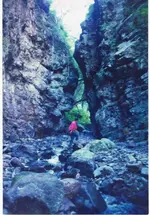
HIO again . This is the actual entance to the Tayopa Canyon complex. The water is from the Arroyo Caudaloso. See Adobies map. Incidentally, that is NOT me in the red shirt.

Doin Jose de La Mancha
 

Attachments

  • Entrance to Tayopa canyon  pp1©@.jpg
    Entrance to Tayopa canyon pp1©@.jpg
    77 KB · Views: 1,501
Don Jose de la Mancha wrote
Allo peeps, Oro de Tayopa: Perhaps you can appreciate why Tayopa has been hidden for almost 400 years, even after entering the area.

I am beginning to get it!

Don Jose also wrote
HIO again . This is the actual entance to the Tayopa Canyon complex. The water is from the Arroyo Caudaloso. See Adobies map. Incidentally, that is NOT me in the red shirt.

It is easy to see now, why mules were vital and no ox-cart road was built. It is not practicable, and would be tough today with heavy equipment.
Roy
 

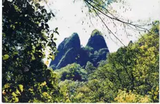
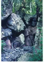
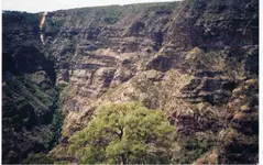
Good morning Oro de Tayopa: this is part of the road to Tayopa. Notice the evidence of the amount of water flow, showing why in the rainy season it was necesary too construct the pole road.

Yes oro de Tayopa, that area sets off Gold placer tank trap thoughts in me also, since it is in the exit from the Paramo, which was the Gold producer of Tayopa..

The pictures are a bit over sized in order to give you the impression intended of the size and feeling one gets there.

Don Jose de La Mancha
 

Attachments

  • Further  on the entrance to Tayopa  ©@.jpg
    Further on the entrance to Tayopa ©@.jpg
    135.7 KB · Views: 1,557
As you mentioned, areas like that HAVE TO have placer gold available if you can get down far enough. Years and years of run off and erosion from gold/silver producing areas has to leave some pretty good signs there!

Really nice photos RDT!
 

Cubfan64 said:
As you mentioned, areas like that HAVE TO have placer gold available if you can get down far enough. Years and years of run off and erosion from gold/silver producing areas has to leave some pretty good signs there!

Really nice photos RDT!
weekender said:
Awesome Pictures !!!!
Keep em'
coming
-Weekender

Ditto, and ditto! :icon_thumleft: :icon_thumright: <2 thumbs up!>
 

Hola amigos,

Don Jose I have a special request; if you have a photo of a Guerigo tree, one of the key identifiers of the true location of Tayopa, I would sure appreciate it if you could post it. (It also helps to seal the case)

As I understand it, the Guerigo is a species of Cottonwood; Populus brandegeei, or Populus deltoides ssp. wislizeni (Rio grande cottonwood) or Guerigo fremontii (Fremont Cottonwood) so really I don't have a clue which is the correct species; the two noticeably thick Guerigos are most likely long dead/fallen/cut down by now, and this being a type of Cottonwood also raises another set of questions. Some of those who searched for Tayopa mentioned seeing pieces of furniture made of Guerigo wood, and Cottonwood has a tendency to split and crack very badly (making it very poor wood for furniture) which makes me suspect this must be a very different sort of tree, perhaps not even a species of Cottonwood.

<best online image I could find on short notice of what is supposed to be a Guerigo>
SAW_02834.JPG


The species description states the Guerigo can grow up to 100 feet tall, again this would be noticeable from a distance. Are the leaves narrower than the common western Cottonwoods? Any info you care to post would be helpful, thank you in advance;
Roy
 

Wow again! I wonder if I could even make it across that kind of country. It is however beautiful, and is having an effect.

Don Jose wrote
To the left, behind the hill, lies the Los Remedios mine, which i now call Teter's mine.

May I ask why Teter's? Thank you in advance.
Roy
 

Gracias amigo, that makes perfect sense! :thumbsup:

In a couple of other threads, foundry slag was quite a topic as evidence of smelting of ore at two Jesuit missions; what about finding any slag at or near the actual mission church site? This of course leads to my next question, if you found any slag, did you ever send any sample of it in for an assay? Thank you in advance;
Roy
 

Evening Oro de Tayopa: No, I haven't looked for any simply because I had positively identified Tayopa without it , and have tried to keep an extremely low key. At this point there is no need for it.

In the accompanying picture the saw mill is on top, Tayopa lies to the left about 1/2 way, in plain sight, even closer. The light yellow streak is the sawdust that they dump down into the Tayopa Barranca.

The green growth is from water draining from one of the tunnels, still closed. There is a 12 ft arrastre - drag mill - down there, now under debris still intact. It was still exposed when I first found Tayopa, a Mexican had been working it getting extremely good gold. After getting enough to retire, he never came back.

Don Jose de La Mancha
 

Attachments

  • Head of Tayopa barranca with saw mill on top ©@.jpg
    Head of Tayopa barranca with saw mill on top ©@.jpg
    92.8 KB · Views: 1,441
Great photos RDT! It makes me want to pack up and go exploring!!
 

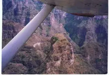
This is an aerial photograph of the southern end of the Tayopa crest, which lies N just beyond the wingtip.. Notice the depth and sheerness of the canyon walls in the foreground. In some places you can touch both walls, but the top may be hundreds of feet of almost sheer cliffs. A good place to keep out of when it it going to rain.... Aircraft is at 6000 ft on the nose.

Don Jose de La Mancha
 

Attachments

  • Aerial view of te Tayopa zone (partial) ©@.jpg
    Aerial view of te Tayopa zone (partial) ©@.jpg
    63.2 KB · Views: 1,301
Wow Don Jose. Incredible. :o :o :o :thumbsup:

The more I study those photos, the more I feel out of shape at the very thought of trying to get over and through that country!
Roy
 

Oroblanco said:
Wow Don Jose. Incredible. :o :o :o :thumbsup:

The more I study those photos, the more I feel out of shape at the very thought of trying to get over and through that country!
Roy

I know what you mean Roy, but imagine what treasures await the person or persons willing to pit their endurance and strength against that formidable terrain :). I know for me at least, the rougher the terrain, the more I daydream about the wonders it may hold because nobody else braved it!

Set a date and I'll meet you out there :)
 

Top Member Reactions

Users who are viewing this thread

Back
Top