Good morning Ladies & Gentlemen: Oro de Tayopa, you asked -->One of the things I have been wanting to ask you for some time is, did you find any evidence of recent visitors to Tayopa, the very first time you saw it?
*****************
Yes of course, the main rainy season trails from Ariaschi, Yoquivo, and north to Moris cross just above El Paramo. The place where Dobie 'claims ' that he was camped. This is where a mule train joined them for the night and shared roasting corn, and is prob within 400 meters of the Northen edge of El Paramo. This the south, Eastern edge of the sierra de Obscuro. The southern Sierra Obscuro is where that huge Grizz lived. Also there is a new lumber mill overlooking the Tayopa canyon, perhaps 5 -600 meters from the small church site on top of Tayopa, as indicated in Dobie's map above..
Also the proposed camp site, as mentioned, lies approx. 400 meters to where the Arriero supposedly blew his cow horn listening for the returned 3 echos. This is also correct, see Dobie's drawn map above. If he blew down into the Paramo, the sound would go straight down and be reflected back by the angled cliff, it would also be reflected to the right into the Tayopa canyon where it would also be reflected to the head of the Tayopa canyon by that angled cliff, while being reflected back into the Paramo and the horn blower. the sound wave that was directed of the head of the Tayopa canyon would return the same way, This would give the three returns at different intervals as mentioned, also the time interval would also tend to modify the frequency.
Since this is on a still well traveled, rainy season, animal trail, it is used quite a bit, and naturally, this campsite is often used since it is at the top of a long high climb. It is a flat area about 200 x 400 meters with fire wood readily available and some water.
===============================================================================================
You also asked --> I was wondering if any other treasure hunter had been in Tayopa, perhaps without even realizing it.
***************
I haven't the slightrest doubt that many have. As you mentioned , the key is realizing it. There was no large portal, it was covered. As for dump ore, no problem, it was merely shunted down into the narrow canyon floor where it was quickly covered by the Heavy summer rains and hurricanes that periodically cross over the area. As for the main workings, they were two huge stope areas, one above the other. Apparently there was very little dump rock to dispose of, most was processing or shipping ore of Ag---- Silver..
I will state this Right now, please don't ask me how I know this with a still closed up mine, I am not at liberty to discuss this on a public media, but will show & prove this you when we meet.
=======================================================================================*
You also asked --> scalp hunter, like Kirker> Thank you in advance;
****************
Frankly I haven't the fainted idea if they ever did , but am very sceptical since the present data suggests that they were far to the North and East of the tayopa area.
========================================================================================
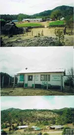
You also asked--> what about ruins/foundations of Indio houses etc
****************
The picture of the Indian's hut above, was built on the basic area of the Workers of Tayopa. That was down on the flats below and south of the Tayopa canyon.
=========================================================================================
You also asked --> it seems like Tayopa was repeatedly attacked and abandoned several times, but could this be simply a "connecting the dots" where they are not, as in one Tayopa is attacked and abandoned, then a "new" Tayopa is later attacked and then abandoned etc?
****************
As far as I know at this point, Tayopa was abandoned / closed up in the 1600's and never reopened. But the area was exploited when they Jesuits returned
=========================================================================================
Oro you posted --> I think I am going to have to start buying some topo maps for Mexico,
************
Save your money, the area is too broken up for the normal lines to be drawn, they are just dashed lines. See post no. 26 above with the Tayopa property lines drawn on it, that is a topo map of the area.
=========================================================================================
You posted --> I have quite a time trying to convert the Jesuit longitude (measured only easterly from Tenerife in the Canary Islands) to our modern longitudes
***************
Remember they didn't have the accurate timepieces needed to do this, they had to go by noon day shots. Even so, they did remarkably well.
========================================================================================
You asked --> Is there a record of all the 'official' Reals?
***************
Yes, but Tayopa never was an official Real, if it had been, it would never have been lost.
=========================================================================================
You posted --> This timeline I am tentatively identifying Tayopa #1 with a place also called San Juan del Rio, and Toapora.
*************
Tayopa no. 1 was at the Guaynopita/ Guaynopa zone.
K, this will do for this morning my friends. Feel free to ask what ever you are curious about or question.
Don Jose de La Mancha el *Tropical Trampo*


 ?
? 


 Good one amigo!