Swift Silver??

Just a curiosity, but today I read a copy of Swifts journal for the first time. It mentions the 83rd meridian, it runs almost right through one of the locations we have suspected was a silver mine. Got my heart pumping.

They were very accurate in those days with the longitude meridian but not the latitude. The 83 meridian runs all the way through Kentucky from the south edge to the top edge, anywhere along that line.
 

They were very accurate in those days with the longitude meridian but not the latitude. The 83 meridian runs all the way through Kentucky from the south edge to the top edge, anywhere along that line.

I seen that. I think it's wild that it runs directly over top of one of the mine locations Im interested in. I'm not say in its Swift but that's Wow
 

I just checked the longitude and it is very close to the coordinates given in the journal, to close to be coincidence

Now search out the old Indian Trail Maps and the formation of the Kentucky Counties and it will reveal even more to you. Especially the Jefferson and Frys Map.
 

Last edited:
Last edited:
I remember a discussion in one of these threads about the meridian being moved around that time. Depending on which location you start counting from, throws off the 83 by 100 miles or more East or West.

This what your talking about Brushy?

https://www.topoquest.com/map.php?l...3&zoom=8&map=auto&coord=d&mode=zoomout&size=m

This map is closer to the actual 38N 83W

https://www.topoquest.com/map.php?l...nad83&zoom=8&map=auto&coord=d&mode=pan&size=m

The journal I read gave 37 min 56 degrees N
 

The journal I read gave 37 min 56 degrees N

You mean 37 degrees 56 minutes???? I hope....

56/60= 0.93333 minutes .......

If so, that puts the Journal you read in Paintsville area.

https://www.topoquest.com/map.php?l...nad83&zoom=8&map=auto&coord=d&mode=pan&size=m

that's a reputed area of the mines from days gone by, and an area sacred to Indians because of all the painted cliffs and trees that used to be there. It does fall in or near an area that Swift had owned. John's Creek is supposed to be named after him and is near Prestonsburg,KY. and near Jenny Wiley State Park.
https://www.topoquest.com/map.php?l...3&zoom=8&map=auto&coord=d&mode=zoomout&size=m
 

Last edited:
You mean 37 degrees 56 minutes???? I hope....

56/60= 0.93333 minutes .......

If so, that puts the Journal you read in Paintsville area.

https://www.topoquest.com/map.php?l...nad83&zoom=8&map=auto&coord=d&mode=pan&size=m

that's a reputed area of the mines from days gone by, and an area sacred to Indians because of all the painted cliffs and trees that used to be there. It does fall in or near an area that Swift had owned. John's Creek is supposed to be named after him and is near Prestonsburg,KY. and near Jenny Wiley State Park.
https://www.topoquest.com/map.php?l...3&zoom=8&map=auto&coord=d&mode=zoomout&size=m

Wasn't Jenny Wiley the woman kidnapped by Chief Watts in North Carolina and carried off to Kentucky to cook for the Swift Party?
 

Last edited:
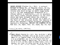
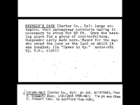
I don't enjoy the research part much, except when I find something, these are from the archives at MSU:
Screenshot_20180124-003328.jpg
Screenshot_20180124-003450.jpg
 

You mean 37 degrees 56 minutes???? I hope....

56/60= 0.93333 minutes .......

If so, that puts the Journal you read in Paintsville area.

https://www.topoquest.com/map.php?l...nad83&zoom=8&map=auto&coord=d&mode=pan&size=m

that's a reputed area of the mines from days gone by, and an area sacred to Indians because of all the painted cliffs and trees that used to be there. It does fall in or near an area that Swift had owned. John's Creek is supposed to be named after him and is near Prestonsburg,KY. and near Jenny Wiley State Park.
https://www.topoquest.com/map.php?l...3&zoom=8&map=auto&coord=d&mode=zoomout&size=m

Thanks for correction Hiker, Iz tired, had done lots of read in and lots of paperwork in front of me.


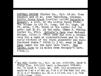
Interesting you found a natural bridge in that section! I thought there was only one in KY (over water). It sounds like its too high to be over water though. I assume it no longer exists? I am sure both Boomer and Curtis would be interested in that source!
 

Last edited:
Interesting you found a natural bridge in that section! I thought there was only one in KY (over water). It sounds like its too high to be over water though. I assume it no longer exists? I am sure both Boomer and Curtis would be interested in that source!

It says it crosses Little Candy Creek
 

Interesting you found a natural bridge in that section! I thought there was only one in KY (over water). It sounds like its too high to be over water though. I assume it no longer exists? I am sure both Boomer and Curtis would be interested in that source!

That's 2 different Rock bridges, one on Swift camp Creek which I wasn't aware of, not in Carter County anyway, and one over Little Caney creek. It isnt standing that I know of, but I haven't been all the way up Little Caney, but I can't find it's location on Google maps
Also I talked to a local and he told me that a little way up Big Caney from the boat dock there is a spring that used to "Spout" water, he said he had drank from it as a kid. He hadn't been it to in decades. From what I gathered you could drink from a kneeling position. He kept say in ya didn't even have to get your belly wet to drink.��
 

Last edited:
It says it crosses Little Candy Creek

219 ft long 196ft high.....that would be one narrow section between the ridges. It must have collapsed? Being only 5ft thick and 12ft wide in the middle, that would make sense.
The one on Swift Camp Creek is no higher than 20ft over the creek and actually resembles a bridge. Its in the Red River Gorge...and is supposed to be the only arch in KY that is actually a bridge (stream flowing under it).
 

That's 2 different Rock bridges, one on Swift camp Creek which I wasn't aware of, not in Carter County anyway, and one over Little Caney creek. It isnt standing that I know of, but I haven't been all the way up Little Caney, but I can't find it's location on Google maps
Also I talked to a local and he told me that a little way up Big Caney from the boat dock there is a spring that used to "Spout" water, he said he had drank from it as a kid. He hadn't been it to in decades. From what I gathered you could drink from a kneeling position. He kept say in ya didn't even have to get your belly wet to drink.��

I'm no geologist but that sounds like thermal pocket pressure? Did he say if it smelled of sulphur? or warm?
 

Top Member Reactions

Users who are viewing this thread

Latest Discussions

Back
Top