Swamp Gold

Salvor6 said:
Ya I read the other thread. I'm really interested in this treasure. Can Horseshoe Head be reached by going down L-28 in a boat? Wheres the nearest launch ramp?
You can get close to the head by using a boat down L-28 but you would be better off with an airboat. At the end of the canal, you need to walk thru sawgrass a couple miles. The problem is that you will not get permission to search Indian lands and the rangers are out in full force. I work in the area and I dont want to jeaperdize my job without permission, but Im working on it.

I need to clear out my email if you want to talk. Keep in mind that I cannot find any factual evidence of this gold but there are plenty of articles in Treasure Magazines about this cache. Do you have an airboat? I only have a canoe.


Horseshoe Head may not be the location but here is Mindsparks post: (I have older references)

The original article appeared in a treasure magazine back in the early 80's.
Hully Sterling was giving flying lessons over the everglades when he found the royal poincaniana trees; flying closer saw the remnants of cabins. The article said he was about 30 miles from Ft. Lauderdale. There was no Alligator Alley back then so it took him 3 days by airboat to actually locate it.

I took that lead, measured about 30 miles on a topo map and circled an area to search. I had a friend who flew and I paid him for his gas and he flew me out to look around. There is only one head that has the royal poinciana trees. So that is how I was able to find the name of the head on the map.


I have access to an airboat, rangers are out in full force? How many do they have working? Any ideas?
 

sabre15 said:
I have access to an airboat, rangers are out in full force? How many do they have working? Any ideas?
Its a huge area to search. I would like to research more, before blindly walking through the swamp, which I do almost every week because Im working in the Big Cypress at this time. That is why I started this thread to gather and share information. I think finding the map with the road from Fort Shackleford is a big clue.

As far as Horseshoe Head, I have never been there. Its on the Miccosukee Indian Reservation. I dont think trespassing is allowed. I wouldnt mind riding out there in an airboat but I think permission would be needed. I dont know how many wildlife officers the Miccosukees have, but they have them. They patrol with airboats and airplanes. Its also hunting season in the Big Cypress. The park has rangers in airplanes and on the ground.. I dont know what happens to people that are caught breaking Indian law. Indian jail? ??? I need to ask around.
 

An elderly lady came into my station in the Big Cypress swamp looking for directions. She stated she hadnt been out here for over 30 years and she had a road map even older and I noticed it immediately. The map had no Alligator Alley or Snake Road. It did however show 3 different road or trail branches south of Devils Gardens near Fort Shackleford. I wish I could have taken a picture of it but I was busy. I need to find this map.

Im headed out to Hendry County tommorrow with a friend of mine to look at property.

I also need to research a list of articles given to me by BridgeEndFarm.

Here is Mindsparks post from sabre15's thread. Im reposting it here to have it handy. Also so it doesnt get lost.


I am new to this forum, but have been reading it for some time but only joined recently. It is amazing on how much misinformation circulates. As far as the lost gold in the everglades; there may have been two separate incidents or have been actually the same. One was transporting 500,000 in 20 dollar gold pieces from the New Orleans mint to Havana. (Supposedly KGC) They got lost and "I think" the shipment was split up and buried at a few separate locations. The second story is that they were transporting $200,000.00 in payroll and got lost, being chased by the enemy, burying the gold at a junction of two creeks. (not Shark and Harney rivers) Between Alligator Alley and SR41. I spent 10 years looking for both of these and can tell you a five square mile area that is definitely not in. But if you are looking for one of them, the last camping place of the Confederates was on an island in the Big Cypress called Horseshoe Head. This was discovered by Hully Sterling who was giving flying lessons out of Ft Lauderale in 1949 when he spotted Royal Poincania trees (not native to the region) Flying closer he saw the remnants of cabins. It took him 3 days by airboat to find the place and when he did, he found Confederate stamped "CSA" items left behind. This was supposedly the last camping place. I rented an airplane and found the head myself back in the 80's and have a video of it. It is 8 miles south of alligator alley. You can google it. (Go across alligator alley west from the beginning and about halfway you come to a canal with a pumping station on the north side of the road. On the south side a dirt road runs next to the canal south for about 7 miles and turns east. Just south of the east road 1 mile there is a big hammock (island) that is Horseshoe Head. It used to be a pineapple plantation back in 1860's. This was probably the Confederates last camping spots. This is where the cabins were found. Now that I told you, here's the catch... it is on the Seminole Indian Reservation, and they do not like anyone on it. You could end up as alligator food for being and doing something they don't care for. You will also need an airboat to get there. I had a connection who would get me there with a few trusted Indians with airboats and make everything OK for a cut, but if I ever were to actually find it, I think I would end up being reported lost in the everglades. So, I decided not to do it.

Now the other gold shipment or payroll is on Federal Land. One of the locations is less than 1000 feet from alligator alley. Federal Land, fenced, posted, swamp, snakes and alligators. But it is there. Actually seen the map of the locations back in 1984. Long, long story of were the map came from. A treasure hunter friend of mine was contacted by an attorney to contract salvage rights for his client who's father left him the map. The client was 78 in 1984. My friend lived on the west coast and contacted me to determine the feasibility. Not knowing the location I needed something to determine the effort required. So the old fellow snapped some pictures of the map. It was about 3' x 4' and an original. Then took close ups of a few locations and cut them out so there was no reference to the rest of the map and sent them to me. He sent me a picture of the map he took at a distance so as not to reveal anything. I had it blown up at a photography studio and bam there it all was. I was also able to identify the locations after comparing the cut outs to the same copy of the map I got from the historical society.

I said I would do it and then he says, "OK, now let's contact the government so I can legally claim it" I told my friend to tell him if he does that he loses it all. And that is were we parted ways. I doubt seriously he ever did anything with the map and the area is so treacherous for someone that age, who by now is 103 or dead. So the stuff is probably still there. Great Story eh? I had the gold bug bite me and I was fanatic over it for 10 years. I even gave away my detectors and quit altogether. I still like to research and read the forums.

Oh yeah, the Calico Jack treasure... I been there too. It is in the Everglades National Park. They take a dim view of detectors. You need a boat to get there. If you get caught, they take the detector, and the boat and throw you in jail. The islands are nothing more than mangrove islands with perhaps a small bit of land in the center. You would have to climb over mangrove roots to get to the center. Wouldn't be able to swing a detector unless you burnt everything off. I camped at the Canepatch (a park campsite) and once supposedly used by pirates and plumehunters. Didn't get much sleep because an alligator came up on shore around our tent. The only way I would go look for the Calico Jack treasure is if I had a map with an x marks the spot and was signed by him personally... not this lifetime. If you ever been the the everglades during mosquito season, you can be drained of all your blood in an hour.

Hope you enjoyed reading of my exploits...


NOTE: Hully Sterling scattered Malelueca seeds over the glades from his airplane. I think his father owned a nursery in Davie. His name is mentioned here: http://www.bioone.org/doi/pdf/10.2179/05-27.1
 

Mindsparks next post:

With the name Hully Sterling, who flew airplanes back it 1949. I would say that that is probably the same person that ruined our ecology.

The video I have is of a lot of dashboard of the plane and a few good shots of the hammock and the poinciania trees as I stuck it out the window. We circled a few times. But in order for me to get some good shots my friend (the pilot) had to slow the plane down. He kept telling me we were at almost stall speed; I didn't get it, but later found out we could have dropped out of the air and crashed. Anyway, not much to look at in the video. Thick brush tops of trees, no open areas in the hammock. You can google earth it and do as well. Actually better.

I tried to figure all the angles on the cache. You see supposedly the Confederates were taken in by a buch of " foot washing Baptists" as I read in one of the treasure mags. So the hammock was a small sugar and pineapple plantation. Now you aren't going to bury a quantity of gold where all of these people are living in case you are being followed. So, I was thinking it may be buried on one of the smaller hammocks surrounding the area. That way, you could post a guard and see anyone coming out from Horseshoe Head crossing the sawgrass. Once you are in the trees of the hammock no one can see what you are doing. Then again, they could have taken it with them, trying to make it to the coast, and when it got really insane, buried it elswhere. I doubt seriously, they went east. Nothing but sawgrass and swamp for miles. West was the Big Cypress. Prairies and Pinelands; some swamps. Probably when they hit some of the swamps going west, they had to make a decision to unload the burden just so they could make it out alive. This is just my thoughts on the matter.


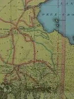
I found an interesting 1856 map of the area. I thought I would post this hard to find map.
 

Attachments

  • seminole war map 1856 lake o.jpg
    seminole war map 1856 lake o.jpg
    38.2 KB · Views: 776
bigcypresshunter said:
I found an interesting 1856 map of the area. I thought I would post this hard to find map.

I have those four forts at the top left mapped out on my Bing Maps account... I've just got to find the time to drive down that way.
I'd really love to detect some old fort sites, though two appear to be on private property.
Sorry it's off subject... that map just reminded me.

Bran <><
 

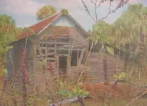
One of the forts on the Caloosahatchee still has a standing structure but its on private property. I have a pic somewhere. Ill try to post later.

Fort Center is believed washed away by Fisheating Creek.

Fort Shackleford was found on the Seminole Indian Res.
 

I figured the two on the river have to be on private property. I'd really like to try to get permission to hunt the sites... and they can keep whatever they want. I'd just like to be pulling relics rather than modern beach stuff. :-\
Oh really? I didn't know that about Fort Center. Huh, interesting. I was wondering about it since it was right on the edge of the lake.
I'll keep my eye out for that photo you're talking about.
Here's a link for some photos someone took for Fort Denaud...
http://www.ghosttowns.com/states/fl/fortdenaud.html

Bran <><
 

godisnum1 said:
I figured the two on the river have to be on private property. I'd really like to try to get permission to hunt the sites... and they can keep whatever they want. I'd just like to be pulling relics rather than modern beach stuff. :-\
Oh really? I didn't know that about Fort Center. Huh, interesting. I was wondering about it since it was right on the edge of the lake.
I'll keep my eye out for that photo you're talking about.
Here's a link for some photos someone took for Fort Denaud...
http://www.ghosttowns.com/states/fl/fortdenaud.html

Bran <><
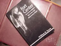
Fort Center was built on an ancient Indian Mound on the bank of Fisheating Creek. Archeaologists believe it washed away.

Somewhere in the bottom of the Caloosahatchee lies some extremely rare Colt revolving rifles. A canoe full of these special rifles capsized during the Seminole Wars and is well documented.

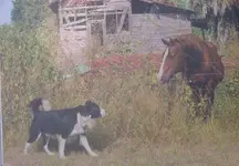
Heres the pics. They appear to be the same place.

fort denaud.jpgfort denaud 2.jpg
 

bigcypresshunter said:
Fort Center was built on an ancient Indian Mound on the bank of Fisheating Creek. Archeaologists believe it washed away.

Somewhere in the bottom of the Caloosahatchee lies some extremely rare Colt revolving rifles. A canoe full of these special rifles capsized during the Seminole Wars and is well documented.

Heres the pics. They appear to be the same place.

Wow, those are some awesome paintings!!

And that's neat information about Fort Center... I guess I would've come upon it had I put more time in researching each of them.

That story you said about the revolving Colt rifles seems SO familiar?! Gosh, that would be amazing to pull something like that out from the water... I just love this hobby. :)

Bran <><
 

The whole story is AWSOME! I love the pictures. I am glad that whomever owns the property didn't destroy the buildings. It kinda makes you look back at history and imagine how it was during that time. When I first came to T-Net I read about those rifles being thrown in the river, very interesting no one has foudn them yet. I have been trying to make it down to Florida to do some looking around on some old historical areas, and hoped to metal detect some places that it is allowed. I was going to try and make it this summer, but I guess I will have to see about the fall.
 

godisnum1 said:
bigcypresshunter said:
Fort Center was built on an ancient Indian Mound on the bank of Fisheating Creek. Archeaologists believe it washed away.


And that's neat information about Fort Center... I guess I would've come upon it had I put more time in researching each of them.
I know this because I read the book. :)
 

Attachments

  • Fort Center Wm Sears.jpg
    Fort Center Wm Sears.jpg
    71.3 KB · Views: 611
bigcypresshunter said:
I know this because I read the book. :)

Ah-ha... the power of good research and a good book! :)

Bran <><
 

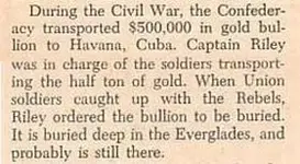
I just read this thread for the first time. Here's what I wrote about this story back in 1964, but don't ask me where I got it from. More than likely it came from a book.

confederate_gold.jpg

I found the following in a book titled "Sunken & Buried Treasure In Florida," by David Martindell (1990).

COLLIER COUNTY:
· Somewhere along the Turner River off Chokoloskee Bay in the Everglades National Park is a 2-acre field covered with 33-pound silver bars buried 6 to 8 inches below the surface. This was a depository for the Seminole Indians.

· The Florida Everglades is the area of a well-documented lost treasure. Near the end of the Civil War, a Confederate paymaster being pursued by Union troops buried a million-dollar payroll - $200,000 in gold coins and the remainder in paper currency. Records reveal he wrote: "Chased by the enemy, we buried our payroll at a point in the Everglades at a junction of two creeks, where the land rises like a camel's back. The money is buried in the west hump of the rise." The area is somewhere between Alligator Alley and State Road 41 in the Seminole Indian Reservation.
 

Jeff K said:
I just read this thread for the first time. Here's what I wrote about this story back in 1964, but don't ask me where I got it from. More than likely it came from a book.


I found the following in a book titled "Sunken & Buried Treasure In Florida," by David Martindell (1990).

COLLIER COUNTY:
· Somewhere along the Turner River off Chokoloskee Bay in the Everglades National Park is a 2-acre field covered with 33-pound silver bars buried 6 to 8 inches below the surface. This was a depository for the Seminole Indians.

· The Florida Everglades is the area of a well-documented lost treasure. Near the end of the Civil War, a Confederate paymaster being pursued by Union troops buried a million-dollar payroll - $200,000 in gold coins and the remainder in paper currency. Records reveal he wrote: "Chased by the enemy, we buried our payroll at a point in the Everglades at a junction of two creeks, where the land rises like a camel's back. The money is buried in the west hump of the rise." The area is somewhere between Alligator Alley and State Road 41 in the Seminole Indian Reservation.
I first read the story in a treasure book back in the early 70's. Its copied in every treasure book since. If you can remember where you got the story it would be a big help. I dont believe someone made it up out of thin air.

Thats the first I heard about the Seminole silver. BTW whats a Seminole depository?
 

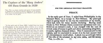
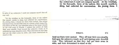
I'm posting the following here to show how authors try to change history for their own agenda. I recently noticed how Jack Beater added his own words to an historical article in one of his books. On the left side is Beater's version, and on the right side is the original 1824 article. First, you'll see that he added the date 1820. The article was written in 1824, but Gasparilla supposedly died in 1821. Second, he changed the name of the ship from "Mary" to "Mary Anders." Last but not least, he added "Gasparilla" in one of the paragraphs to give more credibility to the Gasparilla legend.

Here's a link to the original article on page 169.

http://tinyurl.com/2g86nd8
 

Attachments

  • beater1.jpg
    beater1.jpg
    85.4 KB · Views: 673
  • beater2.jpg
    beater2.jpg
    58.1 KB · Views: 664

Top Member Reactions

Users who are viewing this thread

Latest Discussions

Back
Top