Similarities of the Perfil Map and Frog Tanks Trail

I think we're talking about two different areas, I've been to mine.

This is the area ( in the small rectangle ) I was referring to . Not a place which attracts hikers .

place.JPG
 

:dontknow:I noticed a square shadow up near the top in the middle, if someone knows how to clean up a zoomed in pic, it would be nice. Could be a mine. square.JPG
 

:dontknow:I noticed a square shadow up near the top in the middle, if someone knows how to clean up a zoomed in pic, it would be nice. Could be a mine. View attachment 1500322

Chuck - boy that sure looks mighty squared off to be natural, but I guess until someone gets up there to look there's no way to tell.
 

There is another pic of it on post #7. The pic after my yellow tent. It's up there pretty high.
 

Did I hear that right ?, I knew it. @ 14 minutes into it Ron says it. So what I`m thinking that is what you will see on your way to the mine, not 2 miles after.
 

:dontknow:I noticed a square shadow up near the top in the middle, if someone knows how to clean up a zoomed in pic, it would be nice. Could be a mine. View attachment 1500322

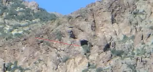
this is about as big as i can make it without it becoming really fuzzy.

Untitled.png

i highlighted in red what kinda looks like an old trail going to it
Untitled.png

interesting spot. nice find!
 

Cave/Mine

Here is a route from Angel Basin to the area. It might be where the mountain lion out there lives.Cave.jpg
 

Stroker

There ( SMM ) exists a map which shows the Perfil mapa region from another angle .
A segment of that map :

Perfil mapa 2.gif
 

Last edited:

Top Member Reactions

Users who are viewing this thread

Back
Top