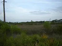
Recent dredge puts iron/pottery on the island!!!

ivan salis said:
640 acres was a typical "section" sized land grant in the 1783 -- early 1820 esh --- late spanish / early american rule time frame .

Ah ok...thnx Ivan. Looks like I went a little too far down the road with that one. ;D
 

The United States acquired nearly nine million acres of land in present-day Georgia, Alabama, Mississippi and Tennessee in this fashion. Panton, Lesie owned up to 3 million acres.

o At its peak, the Indian trade company ran trading posts extending from St. Augustine to New Orleans, and north to Chickasaw Bluffs (Memphis), including posts at Mobile and at several locations in Florida, the Bahamas, and in the Caribbean. By the late 1700s, the Company had annual business activities that exceeded $200,000.

o Panton, Leslie & Co. became John Forbes & Co. in 1805. McGillivray died in 1793, and Panton died about eight years later. It continued to trade as John Forbes and Company until 1847

o After Forbes retired from John Forbes & Co. and moved to Cuba in 1817, he turned everything over to John Innerarity (Panton’s brother-in-law and attorney for the company) in Pensacola and James Innerarity in Mobile. Innerarity Island is named for them.

§ Many Alabamians, including John Forbes, bought ranches in the Matanzas area of Cuba. Forbes moved to Cuba to his ranch, Canimar, where he lived until his death in 1823.
James Innerarity ran the Mobile branch of John Forbes & Co. He was the nephew of William Panton of Panton, Leslie, & Co. He was the first (and third) mayor of Mobile.

o After the death of his wife Heloise (Trouillet) in 1820, James moved the family sugar plantation in the Matanzas Province of Cuba.

o His son was Dr. John Forbes Innerarity (1813-1868), who was graduated from Cambridge, the University of Edinburgh, and the Royal College of Surgeons, London, was a physician in Mobile.
 

humm if that second photo with the large amount of crocky in it was found close by to where the lock plate was please note that what appears to be part of a" trunk hinge" is in the top right of the photo.***
a lot of that crocky looks around 1800 era to me on first glance . P. S. what the coin looking item and is that a ring I see?
 

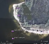
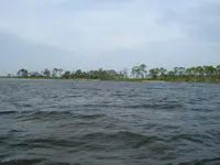
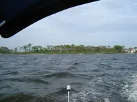
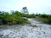
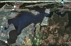
Relicdude, myself, and another friend went out to the end of the island this evening in my boat to do a bit of recon. Here are some photos as well as an attached Google Earth .KML file with the locations the photos were taken.

overview.jpg
Overview of the area

View attachment Innerarity.kml
Google Earth .KML file of the Overview points

Photo1.JPG
Photo 1: Southwest Tip of the Island Looking Northeast

Photo2.JPG
Photo 2: West-Southwest Tip of the Island Looking East

Photo3.JPG
Photo 3: On the Island looking South towards the Bay and Gulf

Photo4.JPG
Photo 4: On the Island looking East towards the canals and lagoon (pond)

Pcola
 

Ivan its some kind of stamped lead,and it is a brass ring...Pcola nice pics. :) Pierre Paul Bouet Lafitte was the son of Jean Francois Bouet and Marianne de Lafitte. He was born on March 4, 1745/6, in the Parish of Pouilleroques, in the Diocese of Lectoure, Roquelaure, Gascogne, France. He was baptized there on March 16, 1745/6. He emigrated from France to Louisiana sometime before 1770, He died there in December 1815. He is reportedly buried along the roadside somwhere between Carmel, Goss and Naborton.

Pierre married first to Mary Magdeline Grappe on April 20, 1770 at Fort St. Jean Baptise in Louisiana. She died on January 12, 1781. They had three children:

Alexandre "Dominique You" (abt 1771 - )
Jean Baptiste Francisco (24 Jan 1776 - 5 Apr/May 1854) m1. Christina _____, m2. Emma Hortense Mortimore
Louis Pierre Boute (1780 - 9 Mar 1844) m. Ursulle Gagne

Jean Baptiste and his brother Pierre were the infamous Barbary Pirates of Louisiana in the early 1800's. They were driven more by their hatred of the Spanish and British than a lust for wealth. It was their aid to Andrew Jackson in the Battle of New Orleans which helped to win the War of 1812. They went straight in 1814.

In 1780, "Paul Bouet Laffitte" is listed as an Infantryman in the Infantry Company of the Natchitoches Militia [Revolutionary War Military Roster].
On June 12, 1784, Pierre and Bauptiste Laffitte received a claim for several hundred acres of land just south of the Camino Real and Bayou Pierre Lake, and west of Bayou San Patrick. In 1787, Pierre bought the adjoining land from Antoine, the chief of the Yatasses, lying "20 leagues from the post of Natchitoches." This is where present day Carmel is located, near Mansfield.
Pierre was a merchant for the Natchitoches Post.
 

Relicdude, the Barbary Coast are the North African states of Algiers, Tunis and Tripoli. There were no Barbary pirates in Louisiana.
 

But there were FORMER barbary coast raiders in Louisiana. Several pirates that saw success in the Indian Ocean ended up eventually returning to america by way of the spanish main. Those that survived the trip around the cape horn that is.

Ah, the good ol' barbary coast. Where barbers come from. :)


Relax. I'm just joking.
 

more like the bourbon ( royal french blood line) raiders-- LOL --but yes some of the old time raiders changed locations when things became too hot in one place or another --- LUIS AURY is a prime exsample of that --- pushed out of texas by a stronger batch of pirates*----- he came to amelia island here in "spanish" florida and using his letters of marquee from venezula and mexico took control of amerlia island from the spanish --he held it for a few months --running fire sales of stolen spanish goods and illegal slaves sold to later be smuggled into "american" georgia --he hurt the rich folks trade so much they demanded that the US govt "shut him down" and since he was also causing "tax" losses thru the loss of import taxes the US govt acted--- he was he was caught by US forces and forced to leave the island after being held for awhile ( the island was "offically" spanish territory --thus really US had no right to invade it ) he left broke his vast amount of cash did not leave with him and has not as of yet been found by me -- :wink: ---there are historical valid documents that prove he got $60,000 for 95 slaves in oct of 1817 and plus he was skimming cash off of all spanish hot goods sold in the townn(1/6 share) to boot (he allowed stolen spanish goods taken by others to be sold in "his" town for a fee---but he only allowed spanish goods --no stolen american stuff* --and he never personally "smuggled" items into georgia himself (he sold to others now what they did with it was their bussiness) the two facts and his letter of marquee saved his life since he had letters of marquee to "offically" war on spain what he did was "offically legal"--thus the US could not "legally" hang him) ---he was in control of the island from oct 1817 to dec of 1817 ---folks were buying like crazy for 1/3 of regular price ---(AURY left the island on pain of immedate death if he ever returned ) --he never did and he died rather poor about 3 years later of broken neck after being thrown from a rather wild spirited horse in the caribbean) so on amelia island is a lot of money buried somewhere, --- Ivan
 

I think it may just be the natchitoches trade post that put the guys together,james innerarity ran the mobile post, and mayor of mobile,john in pensacola was also in charge of the french consol .... Don juan leslie was comander of the free black millita and was a partner in the panton and leslie company.Like many others members of the spanish community ,he had mullato children ,and provided for j.leight wright.... Laffites mom may have been a slave from africa.....
 

Thanks dell for the insight ;D I was always told to follow the money trail,and these guys had the money.As far as the lead containers?Would they have used them as salt lead boxes also?To treat deer hides...I know the indians in the area would pay there debt in deer fur,if not they had to give up land to pay the goods off....Thats how panton company had so much land....
 

Ok I think there is a local (Pensacola) resident that has been lurking on this topic. Yesterday when we went out to the isolated end of the island, we saw some hand-dug holes in the sand along the beach. After seeing several holes like this we were saying to ourselves, "Ok someone else has the same idea or has been on TNET....". Finally we came upon the icing on the cake, a large "X" was drawn in the sand and no more holes beyond that. I wish had taken a picture of it ;D
 

Dell,

If we apply a little bit of logic to your comments we most assume that these lead containers can not be to deep if they are burried on the beach....right? I mean, how deep can you dig in the beach with out finding water, once you find water it makes it imposible to continue digging....right?

Chagy.......
 

Nice post good luck looks like 1830 Glass and Shards with newer goodies, you will find it soon enough, determination shown is impressive very cool
GH
 

RELICDUDE07 said:
.....Time to start detecting .

You single guys have all the fun. I've got the wifey thing going on this weekend since the kids are staying with my parents. For some reason she doesn't consider looking for loot as quality time!!!! :icon_scratch: We can head out there again in my boat sometime during the week next week if you want.
 

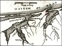
Pcola the one wreck is for sure in the old pass..see how you had to travel around hug the land...
 

Attachments

  • M010204.jpg
    M010204.jpg
    31.1 KB · Views: 250
  • search map.jpg
    search map.jpg
    131.9 KB · Views: 255

Top Member Reactions

Users who are viewing this thread

Back
Top