History of Innerarity Island
and its Development
Much of history is based on our speculation and popular theories. Much of our history occurred long before it could even be written down. Much of our island's history is only recorded in people's minds and hearts. Let us now go as far back as we can, to the time the American Indians roamed these lands and plowed these waters and even before they were called American Indians.
The nomadic Indians traveled up and down the major rivers and waterways, staying further north during the hot summers and enjoying winters in what we now call paradise on the Emerald Gulf Coast. Some tribes came to the Gulf Coast all the way from the Great Lakes, others just coming down from Northern Alabama. Wherever their summer home, these early snow birds made their way to Lost Bay, now called Perdido Bay. They fished the waters near what became to be known as Innerarity Island. They cooked on the island; but they buried their dead across the bay near today's Mill Point and Bear Point. As modern houses were built on Innerarity Island, the utility line and foundation digging would frequently unearth oyster shells, sometimes mountains of them giving us a clue on how the Indians lived on our island. Even today, there are undeveloped portions of our island that contain the remains of cooking areas using pit ovens and mounds and cleaning areas with the remaining shells just beneath the ground foliage. The south shore, protected from the prevailing winds from the north during the winter, was a favorite for the Indians.
The first American settlement was in Pensacola around 1559; but it was lost within a few years. That is why St. Augustine is given the title of the first "continuous" settlement in America. The Spanish were settling in Pensacola and the French occupied Mobile. Neither side were friendly but neither side wanted to sustain causalities and losses in an armed conflict. Perdido Bay became a de-militarized zone (DMZ) which left the Indians as the sole occupants.
In those days, Perdido Bay had actually two narrow mouths into the Gulf and was clogged with wetlands and fresh water marine growth so the access was almost invisible. The Indian name given to Perdido Bay was Lost Bay for its illusiveness. Freshwater would flow down Perdido River and almost to the Gulf before being mixed with saltwater. In 1693, a Mexican cartographer and scientist, Don Carlos Siquenza recorded finding the entrance to Perdido Bay from the Gulf in the vicinity of today's Flora-Bama Lounge and 3 miles from the current Alabama Pass. As our area again became settled in about 1719, fishermen found the shores of Innerarity Point peninsula attractive. The Point was close to the route to the Pass to the Gulf, at that time, being south past Ono Point, down Ole River between Ono Island and Perdido Key, neither of which were then islands, and out into the Gulf. There is no evidence that our island was ever occupied by the fishermen. After all, it was an island isolated from the mainland.
In 1802, John Innerarity came into our area with his grandfather who moved his trading company from St. Augustine to Pensacola. John Innerarity spoke 9 different languages including some of the Indian dialects which were invaluable in trading with those Indians. Innerarity would go into the forests for 6 months at a time and then return with many goods and products that were craved by the Spanish. The first Spanish Land Grant for Innerarity Island was given to Ygancio Serra. A condition for permanent title to this land was to being in a crop. When this condition was not met, the Land Grant was lost. In 1815, the Spanish Governor rewarded Innerarity with several land grants including the island and peninsula that bear his name today. These land grants were not meant for homesteads but for their natural resources like timber.
At the same time, the notorious pirate, John Laffite, came into the area. In fact, Laffite was born in the same year as Innerarity, came to the Gulf waters at the same time, would disappear for 6 months at a time just like John Innerarity. Laffite was a better manager of trading goods than he was a mariner; Laffite had as many as 10 pirate ships under charter so he could focus on trading his captured prizes. During the war of 1812, Laffite helped Andrew Jackson defend the City of New Orleans from attack by the British. Later John Innerarity enjoyed lavish rewards from the hands of the new Governor of Florida, the same Andrew Jackson.
Could these two men, John Innerarity and Jean Laffite be the same man? Maybe. According to the only remaining Society of Jean Laffite there is no evidence to refute this theory. It is possible. John Innerarity settled down and lived full time on our island around 1821, the same time Laffite disappeared off the coast of Honduras under mysterious circumstances. His grave was never known. John Innerarity didn't die until 1854; his grave is in St. Michael's Cemetery in Pensacola.
In the early 1800's the Navy placed a boatyard on the tip of what is today Allegany Point, the first phase of today's Naval Aviation Station. The purpose was to build and maintain the wooden vessels the Federal Government was using to slow or stop the slave trade coming into the ports along the Gulf Coast. The location of the shipyard was made attractive because of many stands of live oak trees. The Navy actually planted more trees along present day Gulf Breeze but the trees on Innerarity Island and Innerarity Point were probably natural.
The pass to the Gulf was long and narrow during these days. Fishermen would spend long hours just getting into the Gulf to start making their living catching fish. Sometime after the end of the Civil War, the Weekly Brothers, more as a lark, tied a "slip pan" or plow to a mule and drove him across the land mass that connected Ono Island and Perdido Key with Bear Point and created a shallow ditch. The theory was that once water started flowing through this ditch that ran now from Perdido Bay to the Gulf of Mexico, that the currents from the tides and the fierce storms would widen and deepen this ditch into a manageable channel that would allow quicker access to the Gulf and give the fishermen more time to fish. That was the beginning of what is now the Alabama Pass of today. By 1918, the water depth was only about 4 feet.
Skipping ahead to the next century, the Navy used Perdido Key and Ono Island for target practice prior to development in these areas. Even today, unexploded ordnance is occasional found buried in the shifting sand. There is no evidence that the trees and foliage on our island were ever at the aim of these important training missions.
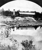
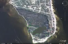
Around 1880, a logging operation was active along the Perdido River with the logs being floated down to mills across from Lillian, Alabama. A shallow manmade cut was also created across the connection going out to Perdido Key but would have been a constant challenge to keep open. Around 1915, a logging operation was begun on Innerarity Island and eventually a mill was put on the island. This necessitated the construction of the first land bridge to connect the island with Innerarity Point. The causeway would have been very rough compared to today's land bridge, only a single dirt lane for the horses and wagons going across. It took 19 more years before the portion of the road on Innerarity Point was finally improved and paved. The lumber mill was probably located on the western end of our island where some old maps still show a structure's foundation which has long since been lost in the wetlands and shifting sands. Today's aerial pictures show ponds and canals that could have been used for this lumber mill.
In 1929, Alabama and Florida saw a need to cross the water from Orange Beach over to Escambia County. Land was bought for the bridge starting on the Alabama side near Bear Point and hopefully passing onto our island and then extending along Innerarity Point and onto the mainland. A company was issued a charter for either building the bridge or starting a ferry service. The ferry service lasted only 3 weeks before closing for the lack of customers. In the 1950s Alabama took over the sole responsibility of building the bridge over Alabama Pass after getting Florida to agree to give the rich tax based Ono Island and part of Perdido Key to Alabama. The first bridge was constructed in 1963 and then the Pass was dredged allowing salt water to encroach well up into Perdido Bay.
The uncertain land tie between Innerarity Point and Perdido Key was severed during the 1930s when a WPA project dug the Intracoastal Waterway using a bascular bridge to get over the waterway and onto Perdido Key. Tow boats hated that inconvenience and would reportedly hit the bridge regularly to knock it out of commission. Today a high fixed bridge replaces the old bascular bridge but the road approaches to the original bridge can still be seen.
Development of Innerarity Island began in the late 1960s when Hamilton Kenner put in a short road along both the north and south shores of Innerarity Island. A few houses were built but records aren't very accurate on where or when. Around 1970, another land developer, Ben White, who also developed the Grande Lagoon residential area, expanded the development on the island. Land restrictions were first documented in 1971 thru 1976 by Mr. White. The first house to be documented was built in 1973 on Innerarity Circle although some remember houses on the north shore even before Mr. White's ownership. Because of very high interest rates during the early 1980s, Ben White was forced into bankruptcy. His accountant, Fayette Dennison, bought the island and actively continued its development. Today, Mr. Dennison still owns the largest number of lots on the island.
Today there are almost 600 home sites on the island, including the Russell Bayou development. There are three property owner's associations, Innerarity Island Association, Russell Bayou, and Sundance for the town homes. Not counting these town homes, there are currently 159 homes as part of Innerarity Island Association and 23 more in Russell Bayou.
During the 1970s and 1980s, 92 homes were built on the island. In 2001, 4 more were added; in 2002, 8; in 2003, 9; in 2004, 15; in 2005, 12; in 2006, 13; and in 2007, there are 6 expected to be finished. Russell Bayou added all their 23 homes in recent years. Lots with houses are increasing at a rate of about 10% per year; so the island should be mostly built up in another 10 years.
http://www.innerarityisland.net/2-History of Island.html

 Just one more thing.If you guys were looking for treasure on this island,would you start at the high ground /bluffs oak tree clusters for the shade in the summer time.Nice and cool or would you start at the lake ,at the end of the island?
 But looks like a great spot ,high ground at the end of the island...I will stay in touch....
 . Oh by the way, besides Pierre, Lafitte's other brother's name was Alexander