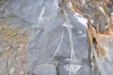
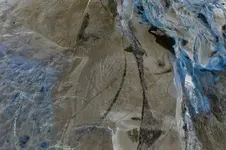
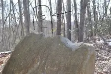
Out of place triangle shaped rock

Jayheazy,

There is an outstanding amount of good information posted here. Because I am "newer" at this than most, I will offer up my current working strategy for solving these types of signs/symbols. Because the meanings of the signs/symbols used was left up to the person who made them, the traditional definiton may get you close, but not exact.

So what I have done in order to "best guess" what the person was trying to communicate on my sites was the following:

1) As accurately as you can, date the site.

2) Plot all of these points on a map

3) Using the corrected declination for the time period, layout azimuths from these plotted points.

4) Where the lines cross, take note, and inspect the area on the ground for more signs.

Using the above method has taken me to two different trails (one in, one out), linking two different sites about a mile away from each other. It's a lot of "boots on the ground", but hard work equals eventual success.

Clay
 

Thanks for the input everyone.

Can anyone tell me what a bow and arrow symbol could mean. How about one that has a really nice 8 just in front of the arrow?

sorry for the poor photo, but I had to take around 30 just to get one that looked decent.

Thanks in advance for your help.
 

Attachments

  • 059.JPG
    059.JPG
    141.3 KB · Views: 1,571
Hey, Jay,
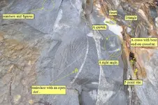
How about this mark up? Could that crack where the bent cross and star is located, represent a canyon?

059 Merged.jpg
 

Saw a very similar bear before. I believe that what you have found was once a sacred site for American Indians which has been desecrated. Someone may have used it as a landmark, but it is of itself unrelated to treasure.
 

blah blah blah........here is a picture, from another site, that shows the same type of 'fallen 5'. I thought this might add some beef to your post.

side5.jpg


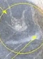
I also just noticed an inverted 'u' with a dot in the center.
tturtletunnel.jpg
 

Shortstack said:
OK, I'll give it a try.
I'm thinking this might be a story rock and not a treasure lead. That name in the upper right is written in script with a swirl underline. The indian head is too detailed to be an old marker. Perhaps the person signed his / her work in the script signature just above the profile. There's a cooking pot hanging on a frame over a fire with smoke billowing off to the right. The horse head has crossed sabres or rifles under it. The teepee has a detailed flap that looks similar to a cursive "A". There's an "A" shape or arrowhead or trail fork drawn on the left side. At the top is a place that looks like a hole that was filled in with some mixture of mastic or glue material.
I use a negative view, per Old Dog. :thumbsup:
Check out topic #75. The Injun to the right in post #43, with the script, also appears in post #75. The image in post #75 is AT THE WATER LINE. In post #75, in the upper left corner (numbers and symbols), is the back of the head dress and the script from post #43. These two images are no doubt within a couple of feet of each other. That is not epoxy or glue you mentioned in post #43, but, water, since they are both at the water line. I don't believe the 'crown' to a be a crown. Just quartz streaks. Those streaks are common in the granites of OK and AK.

I intend no mockery of the post. There are things that are tangible and there are those that are pulled from the clouds. Even in post #43 there is an '8' in front of the chief's nose. What about that?
 

Hey blind.
You are right, both indians are on opposite sides of the same rock.
The only thing about the quartz in the rock is that both indians have a line of quartz under their eye. As if showing the direction they are looking, or the direction you should be looking.

The thing about the second cheif is that it is almost invisible unless it is wet. It is still hard to see even then.

Lately I am wondering if one of these are a false trail. Or maybe I have 2 different trails from this alpha.
 

Frank,

I will check the bottom of that rock the next time I am there, it is almost 1000 miles from where I live.
 

jayheazy said:
Hey blind.
You are right, both indians are on opposite sides of the same rock.
The only thing about the quartz in the rock is that both indians have a line of quartz under their eye. As if showing the direction they are looking, or the direction you should be looking.

The thing about the second cheif is that it is almost invisible unless it is wet. It is still hard to see even then.

Lately I am wondering if one of these are a false trail. Or maybe I have 2 different trails from this alpha.
I looked back at those pictures and I see the lines now. So, maybe the images were intentionally place over a natural feature. The only reasons I could see for that would be so that the artist did not have to A] continue with more hammering and chiseling and B] use a natural feature intended to assist the map yet also intended to appear as a natural intrusion to the map. Interesting.
 

Blind.in.Texas wrote: I don't believe the 'crown' to a be a crown. Just quartz streaks. Those streaks are common in the granites of OK and AK.


There are streaks of lighter colored material in that rock, but it is NOT shaped as a crown. There's a streak coming out of the center spike, which may or may not mean anything. And the Jimmy Hoffa comment was uncalled for.
 

Attachments

  • 059_Merged.jpg
    059_Merged.jpg
    16.2 KB · Views: 1,326
I believe it was post number 47 where I gave what I thought was a reasonable interpretation. I am NOT a fan of ink blot trail markers nor am I an expert, by any stretch, of these S/S. The 'period' next to symbols, as I understand them, means to look down in that direction. The overhang does look like the chief's nose and looking down under the the overhang, I do see the bear and the Indian to it's right. I also see two flat rocks just above the bear. The Indian seems to be looking at the bear.

From the reading I have done, one is supposed to check death traps for obscure information, then use that information to move to the next marker while leaving the trap undisturbed. However, the Indian is looking at the bear and NOT the crevice below the over hang. I think you may need to search that whole area for more clues that may lead to another marker. A death trap could real there and could be the end of the road for you should you attempt recovery. Look at the two flat rocks pinned between the overhang and the top of the bear's head. I wouldn't think those two tiny rocks support that whole overhang but, I'm not there so I don't count. I think maybe any potential stash could be somewhere else. If no other S/S are available, maybe it is the end of the road and a search under that over hang warranted.
 

I will be back at this site in october, snd would like to know how to properly chaulk the carvings to show up better. Any advice?
 

did anyone notice the tree behind the rock in this picture, looks like it is pointing the way to something
 

Attachments

  • DSC_0031.jpg
    DSC_0031.jpg
    139.8 KB · Views: 1,163
Good eyes, jimmyv. I'm pretty sure that none of us spotted that. At least, you are the first to mention it.
 

jayheazy said:
I will be back at this site in october, snd would like to know how to properly chaulk the carvings to show up better. Any advice?

a sack of common flour is bio=gradeable....throw it on and use a soft brush across the surface leaving the flour in the "crack"...

Oddrock
 

Thought i would take a shot! In pic #54 IMHO
1. The teepee door flap looks to be a (7)?
2. The top portion of the (5) is pointing to the fire.
3. The smoke blowing twards the chief's face (overhang)
If smoke was directed under the overhang, would it
possibly come out some place near by maybe close
to a skull or bones to show where something is hidden
or the next clue? Just a thought.

Dave
 

Top Member Reactions

Users who are viewing this thread

Back
Top