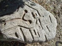
MYSTERY ROCK

Sodabob

Sr. Member
Jan 14, 2019
273
191
Primary Interest:
All Treasure Hunting
Howdy

I haven't been around for a while and had to re-register with a different name. Anyway, I'm working on a real mystery and could use some help. If I can remember how to post pictures, please notice the carved images in what locals call "The Mystery Rock." I have been asked by our local Historical Society / Museum to research it, and depending on the results here, might write an article for them in their newsletter. The rock has already been examined by a group of Archaeologist but they are baffled as to what the carvings might be or represent. The only thing they determined with any certainty is that the carvings were done with some type of steel tool such as a chisel. As for the date it was carved, they are baffled about that as well. Its located in a brushy area about 100 feet away from an old State highway and about 100 yards from an old Railroad line that was built in 1916. In the area there is also an old U.S. military encampment that was built in 1940-41 and sold to the County around 1947-48. The two most prominent theories are ...

1. The rock was carved by a Railroad worker
2. The rock was carved by a member of the Military

But regardless of who carved it or when, we are trying to determine what the carvings might be or represent? The archaeologist said they don't recognize the pattern and are pretty sure they are not Aztec or anything like that, and that they might be random that only the "carver" knows the meaning of.

If you have any theories or recognize the pattern as something specific, please let me know and I will pass the information on to the Historical Society. The rock is located about 50 miles east of San Diego along old Highway 94.

Thanks in advance to those who participate in possibly solving a mystery that has had locals baffled for several years.

Sodabob ... a.k.a. Sodabottlebob and Sodapopbob


The rock is about 6 feet long, 3 feet wide, and about 2 feet thick. Most of the carving are on one end of the rock but in some places continue over the side. The local museum has permits to move it next Spring but will need a backhoe to lift and transport it.
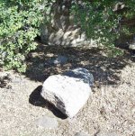
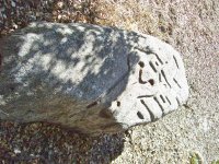
100_5380.JPG

100_5377.JPG

100_5378.JPG
 

Last edited:
I'm going to try and go to the Mystery Rock today and take a compass with me to determine the orientation of the rock to points on the compass. I already know the tail of the Y on the Rock points in the general direction of North, but with a compass I should be able to determine the precise direction the tail points to. The attached sky chart represents Cancer's position in the winter months. The following copy/pasted text accompanied the chart. I especially like the part where it says "Gate of Men" because in one of my previous entries I posted a picture of the Rock with what might be a Phoenician symbol for "Door"

Copy/Pasted

In ancient Chaldean and Platonic philosophy, Cancer was called the Gate of Men. It was through this portal that souls descend from the heavens above and into the bodies of the newly born. The chart shows the position of Cancer over most of the United States in mid-winter at 8 pm. This chart can also be applied to other areas of the Northern hemisphere such as Canada, the UK and Europe. Cancer rises in the north-east and sets in the north-west. In December the constellation will appear in the eastern night sky around 10 pm and continue westward until around 7 am. From January to February it will first appear from the east as night falls around 6pm before setting around 6 am. From April to June it will first appear in the south-west around 9pm and dip below the horizon around 1 am.

Mystery Rock Cancer Position.jpg

Mystery Rock (6).jpg
 

Last edited:
Upvote 0
Is it possible its something to do with a virtual geocache?

I saw this one listed for a Kit Carson Cache and wondered if someone had done something similar.

"When you get to the virtual cache site you will find something not naturally occurring there and conspicuously large. It is the remnants of a human made structure. Many geocachers ask how this structure came to be. Unfortunately, the local history museum curator and the forest service experts do not have any exact information on its origin or purpose. "

Im not familiar with the area so maybe someone can delve a bit deeper, buts its certainly a very interesting find.
 

Upvote 0
I was down there today and took the attached picture. I used two compasses; one of which was from a smart phone, and the other was a typical hand held compass. The fire poker I laid on the rock is pointing precisely to magnetic north, with the tail of the Y pointing in the general direction of geographic north, which is just a few degrees East of magnetic north. I doubt the compass readings will solve the mystery, but they might factor in at some point.

Regarding the slag/clinker I found near the rock the other day, its definitely a piece of slag from the nearby rail line. There are literally thousands of pieces of it on the rail line that I walked along for about a quarter mile. Someone no doubt carried it from the rail line and either dropped or placed it near the Mystery Rock for some unknown reason.

Notice the rust colored patina in the Y symbol. Its not in any of the other groves and is a mystery unto itself.

100_5428.JPG
 

Last edited:
Upvote 0
P.S.

I just got off the phone with the museum curator, who is in charge of the project to eventually move the rock to the museum, and he said the general consensus among the archaeologist and everyone else who has studied the rock are in agreement that the carving was done approximately 100 years ago. Apparently they dated it based on how long it typically takes for a natural patina to develop and obscure any evidence of recent carving. And because the 100 year date correlates to when the rail line was built in 1916, they strongly suspect there is a connection. The best guess theory they came up with is that whoever carved the rock had some knowledge of geometric patterns and/or the type of knowledge that a railroad surveyor might possess. Plus, the immediate area around the rock is like a hollow and would be a great place to pitch a tent and camp. But the real mystery isn't WHO might have carved it but whether there is a message to be discovered in the carvings, and if so, what that message / meaning might be? If anything? Apparently no one has been able to identify the pattern and/or symbols yet.
 

Last edited:
Upvote 0
My last post pretty much sums up everything I know about the Mystery Rock and my hope is that someone will eventually recognize the design and solve the mystery. I still think the Y symbol is a significant clue and that whoever carved it meant for it to be a central figure. While I was studying the Y symbol yesterday I noticed that the center part of it curves to the right. I believe that was intentional because it seems to me it would have been easier to carve the entire Y symbol in straight lines instead of curving the central part to the right. But why that was done I do not currently know and can only speculate. Sometimes speculation is a good thing and can leapfrog to other possibilities. But in this case I have leapfrogged entirely off the rock and into the pond of the unknown. After all, how far fetched can an observation be that includes ancient alphabets and star charts? Thanks again to everyone who has contributed to this discussion. Your observations are noteworthy and have been added to the list of possibilities. If I discover anything else of interest I will be sure and share it and will certainly let you know when the rock is relocated to its new home. In closing, please enjoy the attached image of the rock and the mysterious Oak Tree growing behind it that is literally rooted in a solid rock cliff. Speaking of the solid rock cliff, it has a large letter A carved in it. But that is also a mystery as to who and when the 'A' was carved.

100_5435.JPG

100_5433.JPG

100_5430 (1).jpg

Mystery Rock (1).jpg
 

Last edited:
Upvote 0
Last but not least (because I really didn't want to go there and still don't) is this alphabet written about by Heinrich Cornelius Agrippa in 1533. It is generally referred to as the Angelic/Celestial alphabet and is one of very few alphabets that have circles at the ends of the letters. It involves the occult and may or may not be connected to the Mystery Rock. The Angelic/Celestial alphabet is probably a nothing-burger, but who knows?

Mystery Rock Celestial Alphabet Heinrich Cornelius Agrippa 1533 (1).jpg

Mystery Rock Celestial Alphabet Heinrich Cornelius Agrippa 1533.jpg

Heinrich Cornelius Agrippa's Celestial Alphabet, from 'Of Occult Philosophy', English 1651 edition

Mystery Rock Celestial Alphabet English Translation 1651.jpg


Mystery Rock Angelic Alphabet.jpg
 

Last edited:
Upvote 0
Even though the following may not be directly related to the Mystery Rock, it has me slightly puzzled and I could use some help dating a bullet shell casing I found in the vicinity the other day. (See pics). I already researched it and based on what I found the casing dates to 1912 or earlier. And its the "earlier" part that I'm trying to narrow down and need some help with. The base of the casing is stamped with ...

38 S&W SP'L UMC

According to my research, the S&W stands for "Smith & Wesson" and the UMC stands for "United Metallic Cartridge Company." Apparently S&W and UMC merged in 1912 and any cartridges made from 1912 and later were stamped with "REM." My casing does not have "REM" stamped on it. Hence, I'm thinking it was made in 1912 or earlier. If this is accurate, I'm hoping there is some way to determine a more precise date. I don't necessarily want to start a new thread about it, but will if no one who sees it here has the answer. Thanks in advance to anyone who can help with this.

The casing measures 1 1/8" inch long or 2.9 MM

Shell Casing.JPG

Shell Casing Base.JPG
 

Upvote 0
Another Possibility / Theory?

If you thought I was off my rocker with my alphabet and other theories, see what you think of my latest one ...

Hobo Symbols / Signs

Mystery Rock (1).jpg

Mystery Rock Hobo Symbols (1).jpg

Mystery Rock Hobo Symbols.jpg

Mystery Rock Hobo Symbols (2).png
 

Upvote 0
This pic is especially for the member who sent me a PM and shared some information and dates regarding when the Railroad was completed in the immediate area. I took the picture the other day while I was searching the area for Hobo signs/symbols - which I will tell you more about later. It was near this bridge that I found the shell casing.

Railroad Bridge 1915.JPG
 

Upvote 0
During the course of my research regarding Hobo symbols/signs I found this copy/pasted text ...

"Yard Limit Board = A track side "Y" shaped sign delimiting the boundaries of a yard and the jurisdiction between a yard master and road master."
 

Upvote 0
I especially like these symbols that are on every Hobo chart I have seen ...

Mystery Rock Hobo Symbols (3).jpg

Mystery Rock Hobo Symbols.jpg
 

Upvote 0
I looked at hobo symbols as well. My problem with that theory is that hobos traveled light. I doubt any had stone chisels or stayed around long enough to make those carvings.
 

Upvote 0
It's a Picasso.
 

Attachments

  • the-kitchen.jpg
    the-kitchen.jpg
    139.1 KB · Views: 53
Upvote 0
:icon_scratch: Maybe there is something either buried under the rock, or so many paces along the line from whence the Y points to?
 

Upvote 0
:icon_scratch: Maybe there is something either buried under the rock, or so many paces along the line from whence the Y points to?

The museum people and I are thinking the same thing and plan to dig under the rock when its moved. I have done a little metal detecting already but didn't find anything except some junk like twist-off bottle caps and stuff like that. However, my smartphone compass acted a little weird when I set it directly on the rock. But what might have caused that, I don't know. The compass didn't act up when I held it away from the rock. ???
 

Upvote 0
Even though the following may not be directly related to the Mystery Rock, it has me slightly puzzled and I could use some help dating a bullet shell casing I found in the vicinity the other day. (See pics). I already researched it and based on what I found the casing dates to 1912 or earlier. And its the "earlier" part that I'm trying to narrow down and need some help with. The base of the casing is stamped with ...

38 S&W SP'L UMC

According to my research, the S&W stands for "Smith & Wesson" and the UMC stands for "United Metallic Cartridge Company." Apparently S&W and UMC merged in 1912 and any cartridges made from 1912 and later were stamped with "REM." My casing does not have "REM" stamped on it. Hence, I'm thinking it was made in 1912 or earlier. If this is accurate, I'm hoping there is some way to determine a more precise date. I don't necessarily want to start a new thread about it, but will if no one who sees it here has the answer. Thanks in advance to anyone who can help with this.

The casing measures 1 1/8" inch long or 2.9 MM

.38 Special was introduced in 1898. https://en.wikipedia.org/wiki/.38_Special
 

Upvote 0

Top Member Reactions

Users who are viewing this thread

Latest Discussions

Back
Top