Misc data and adventures of a Tayopa treasure hunter

mexYepache to Yecora4,reduced-.jpg

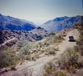
Yecora-Yepache road.
 

Gracias amigo. Noy sure where that is, can you clarify ? After all, it was 70 years ago.
 

Last edited:
Will do. I have just recently begun to digitize my 2 and a quarter slides.
First, that should have read 5 liter of mescal , not 20. It was way to hot of a mix anyway, I burnt one of the prechamber seats on the way to real fuel.
We stayed at the Enrique in Alamos for a few weeks, welding things back onto the car. I photographed all of the interesting doors and windows in town. Which door do you live behind?


I still have not solved the file size issue for pictures of the road. It was new but still had 100 yard of stairs at one crossing. It was buit by a general in 1968, I remember. Just a 2 track but it was the first connection over sierra in that region. I had set out to cross the spine country where ever possible. There were only 6 or 7 possible routes at the time, 2 of them being 4x4 trails. I first crossed from sonora up canon de Carreta to Janos. I think it was Coronados route. Then south through Casas Grandes. Took in the waters at the hot springs in Agua Caliente de Tutuaca and the headed for Yecora.

Here are picts of a hammer I was given in Santa Maria de Trinidad 2 years before the east- west crossing, which was in 1973. Found in an old tailings pile by a miner. It is my go to hammer. "Remember, don't force it. Just get a bigger hammer."

View attachment 1763675View attachment 1763676

That is a nice hammer!
I have been meaning to ask in this thread a long while to all.
Does anyone know the general route Cortés and his army took when they had to run for it from Tenochtitlan? I read a very detailed account of the events but not sure if I can find the link.
Anyway, along their route, according to this account, the Spanish had to discard a lot of their treasure.
I would think some of that would turn up. Maybe a piece found here and there.
Cortés had quite a name ;)
Don Hernán Cortés de Monroy y Pizarro Altamirano, Marquis of the Valley of Oaxaca.
 

I also have to say the Spanish were pretty tough guys. Really amazing what they did here and elsewhere.
Not sure what happened, but it is a wonder we are not living in New Spain.
Of course, I am being objective here. The Spanish could be ruthless, and I've read some of their opinions of the Mayans. I'll post a link to one report.
Meanwhile, it is a dark night. Tornado watches and thunder and lightning all around.
 

Hillnily, make sure the dikes hold. As for the Spanish,, I have to admit that I have forgotten most of Cortes Campagn , I'llpodt when I remember.
 

Last edited:
hi, it was mentioned to me "what did I usted,/was looked like when I married my beloved Berti new doc 2018-06-30 20.56.01_1 (2).jpg
 

Last edited:
Senor Don Jose, that picture you just tried to post said it was not valid. If I may, I have this one, if you want a more recent one, I can do that to ?

P.M. me with which picture you would prefer as I have several and I will accommodate you. :notworthy:

new doc 2018-06-30 20.56.01_1 (2).jpg
 

Sorry Senor Don Jose, when I click on that one, it too says invalid attachment. Please allow me the honors sir: :notworthy:

My child bride.jpg
and a lovely Lady :notworthy:
 

Last edited:
Good morning Don Jose,
Memories and memory are sometimes like the logging roads in the Sierra. Sometimes they go some where you expect and sometimes they don't.
My memories of my trips sometime blend together or omit big parts. Luckily I wrote a log book on most trips. I spent a day searching and found my log books from 1973 when I was navigator/mechanic on a month long exploration of NW Sonora which took us to Sahuaripa, south to Trinidad and then to Yecora and on to Cascada Basaceachic on the eastern side. Our vehicle was unable to get up the grade east of Yecora to the crest you mentioned until I disassembled the carbureator and cleaned the sand and water out which came with the gas we bought in Yecora. Took most of a day to get up that hill.
The crossing from east to west was done in 1975. The log book reveals that after Casa Grandes we actually went via La Junta to The cascada Basaceachic, then to San Jacinto, Creel and down into the Barranca at La Bufa. I was hoping to be able to drive to Chinipas and Alamos either through Ocampo and Moris or from San Jacinto. I could not find a workable route down to Alamos so we doubled back to Yepachic-Yecora rd. What rout did you take ? On the way back NW to Tomachic and Tutuac my log says that a few km before Tomachi we took a "road" that we we told would get us to Tutuaca via Mesa de Correo. After 5 hours of 1st gear cruising the road devolved into a footpath. Only took 4 hours to get back to Tomachic but the day was lost. The photograph may be looking back down the way we had come on this particular diversion. The white cap of the far mesa looks like the country SE of the Rio Mayo.
As you know maps were scant and directions from locals were always different or directly contradictory to the previous directions that got you where you were! Most oral directions disagreed with maps in hand. What fun! Compass time.
Don Jose, We may have met in Alamos in 1975. It was a very welcoming town. I met many very interesting folks. A friend had restored a ruin into a house there in the 60's using beautiful Amapa beams. I was invited by the current owner to see inside and photo. The Enrique hotel had movies or boxing matches in the courtyard in the evening. I remember being told stories of tunnels connection the big haciendas with the church being used to hide from raids by Yaquis.

That train ride is a thrill, it does a 360 inside of a mountain working it's way down near Estacion Temoris

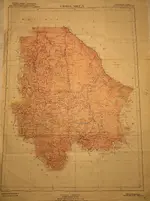
Here is a 1919/1942 map of Chihuahua and a closeup of the area of Tapoya. It shows a mine symbol in a few locations there. Is one of them the Tapoya?

View attachment Map, Yecora Yepache-cleaned.jpgView attachment Map, Chihuahua-cleaned.jpg
 

I seem to find myself being bouncing around in the backseat with no seatbelt and my eyes wide open as a child, taking in every site and sound and all of the beauty and moments of horror that come with your adventure.

Thank you for sharing your marvelous, and well written adventure.

I am, officially, a fan.

#/;0{>~
 

Last edited:
Thanks for the kind words Prospector. I am happy to add some photos and stories to add to Don Jose's stories of the quest for the Tapoya legend.
Although sitting a t a desk and typing are not my favorite activities. Give me a shovel and I am happy.
I was not aware of the treasure stories when I was there. If I had been I would have turned to the south at the crest above Yecora.

Unfortunately no photo notes were taken so I do not know the exact locations but it is possible to figure the approximate location by the vegetation.

I have hundreds, but only a handful are scanned.

To solve the big file problem I simply photoed the image on my screen to get a smaller version.

This good road is in Sonora judging by the Ocatillo.

Sierra  road-cleaned.jpg


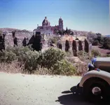
A old church and ruins in the sierra. Made of small stones.

Ruin along the road-cleaned.jpg
 

Tayopa(I finally got it right) Adventure Land Map

View attachment 1764984

My referenced to San Jacinto should have been San Juanito. upper right side of the map, above Creel


Great map.... now I truly appreciate
Don Jose’s decision to ride his mule.

Many places seem to be, hi lift- super articulating, 4X4, off-road trail vehicles(ONLY), with high capacity wenches!!!!

I could be wrong, but why risk it??!

A very good map, especially where local word of mouth is unreliable.

Thanks,(As if I could ever make that trip, in the shape that I am.)

#/;0{>~
 

If I have the scanner set up properly this is the next page in the skull [emoji88] story.
I hope it is readable.
ImageUploadedByTreasureNet.com1572033436.511839.jpg

#/;0{>~
 

Top Member Reactions

Users who are viewing this thread

Back
Top