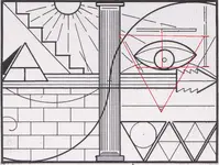
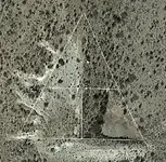
Lue Map

The L U E is NOT KGC or Masonic it is Spanish. To think otherwise is folly. All of the L U E is on private property and it is extensive and encompasses an area of at east 30 square miles. Read about the map by KVM “Treasure In The Valley Of Secrets” therein lies the answer to all your questions about this famous map like no other.
 

Last edited:
Very interesting pic I ran across in another thread: https://www.treasurenet.com/threads/found-in-colorado-saguache-county.612547/#post-6275991 This is roughly just north of Conejos Peak, Colorado. I've read that the LUE is rumored to go as far north as Salidia, Colorado. What I find interesting, is this is the first carving site that could possibly validate the carving drawing in ToVoS @ Conejos peak, and also the rumor of multiple caches.
You are too far west south west.
 

Why? This always bothered me about this guy.
The more names you could write under the more money you could expect to receive from the same publication. Sometimes you could see both Deek Gladson and Karl Von Mueller in the same magazine thus you could get twice as much money than just having one article.

I hope this answers your question.

Regards

LUE-Hawn
 

Has anyone come across the petroglyphs or pictographs documented in KvM's ToTVOS in their travels across Colorado or the Enchanted Land ? Anyone seen an actual photograph of them in situ ? There's scores of photography, travel blog, academic, and amateur interest websites available to us - surely there would be a photo of these unusual designs taken in the past 50 years.

View attachment 1677716
Hello Ryano,

In answer to your question all of them.

Regards

LUE-Hawn
 

Why is the LUE Map captioned "Redrawn exactly from the IAYAYAM Key" so casually like it goes without saying that everyone should know what it means? Why was KvM not asked to elaborate further? Why did no one seem to even care about IAYAYAM until after the death of KvM? Could "The IAYAYAM Key" simply be the name of the original map that was copied and re-named the LUE Map? Did KvM and Co. understand these acronyms or publish them in an attempt to gain information? Could it be no help in knowing?

Assuming none of the above matters:

Do we know the actual size/scale of the LUE map?
Has the "Dollar Bill Key Cipher" idea been abandoned? If not, what series bill should be used?
Does anyone still think the 4 Corners area might have anything to do with the solution?

In an attempt to simplify the starting point, I am going off the idea that there is more disinformation in the LUE map than useful information.
I have been playing with overlaying the LUE map centered on the 4 Corners area. If you mark the thick sinewave on the map and rotate the map until the thin sinewave overlaps, interesting things happen. For one, it is 33 degrees rotation to overlap the sinewaves. At the same time the shaded side of the pyramid points due north.

This is where scale might become important. If the LUE Map's original scale matches up with a dollar bill of the era, several things need to be tried. Would be interesting to scale the LUE map so that when centered with a dollar bill the pyramids align. When the pyramids align where does the key fall? On the small pyramid? Is it also 33 degrees rotation?

So now you have the dollar/key marking the spot on the LUE map and the LUE map overlayed on the 4 Corners map rotated 33 degrees and pointing due north. What scale 4 Corners map do you use? The boundary of the 4 states?

I have only just begun the overlaying and scaling but interested in thoughts on this line of direction.
Look at Charles Kenworthy book on the lost Dutchman Mine it will give you the answer.
 

Why? This always bothered me about this guy.
At that point in time the mid 1960 to the 1970’s the more names you wrote under the better chance you could write articles for the same magazine and get paid a percentage of the sales. You could have three articles in the same magazine and get paid for three names instead of one. Several writers did the same thing. Look at Randy Bradford’s L U E video presentation by Terry Carter Treasure Hunter. Randy says the same thing I mentioned above.

Bests

LUE-Hawn
 

There are three possible "best" possibilities in my estimation, strangely they are interconnected.

1.) The LUE is in fact one in the same as the Lost Frenchmen gold of Treasure Mountain. Lots of overlapping aspects to both stories. Explaining it all would probably be best done in a separate thread.
2.) KGC, Bob Brewer has confirmed this suspicion but I'm always open to new ideas and information. This is the hardest one to validate, but when you can easily eliminate some other possibilities the KGC stands as a distinct possibility.
3.) The KGC using the Treasure Mountain story as a cover story. Given the origins of the Treasure Mountain story and how it came to be published out of the blue in the early 1900s, I've speculated at how strange it is so much was written of a story that had not previously existed. If you look at other well-known stories like the Dutchman, the Lost Adams, the Lost Cabin, Pegleg, etc., those stories stretch back well into the 1860s. You see them mentioned time and time again in early newspapers. The Frenchmen story just appears on a vast scale out of nowhere.
4.) I haven't ruled out Spanish/Jesuit collaborating, but there just isn't much there to run with beyond thin speculation.

What the LUE is NOT:
Nazi
Mayan
Aztec
Number four (#4) is correct its Spanish without doubt.

Its neither French, KGC or as Randy put it Nazi, Aztec or Mayan.

Regards

LUE-Hawn
 

Fellas and gals, (This post is 32 lines long, but I'm gonna say a few things I need and want to say.) I hope this is going on the post made by Randy Bradford a couple of weeks ago.
Many a post is on this site trashing me and John London. The main antagonist is Franklin real name Albert Atwell. Poor soul is so upset with us because he knows we know more about the treasure in, well not in, but rounded off probably about 22 miles from Danville. Seems like nearly everyone searching for treasure around D'ville thinks the only treasure ever put down there was the Mexican 8 R coins thought to be missing from the Confederate Treasury in 1865. The story of the CSA treasure is intentionally interwoven in a treasure tale much later than 1865. In the book TREASURE IN DANVILLE, VIRGINIA, by a man named J. Frank Carroll are the clues to solving the, not CSA, treasure near Danville. For those who don't know it or perhaps never thought about why some people writing about or dealing with buried treasure use the code name "J. Frank. There was J. Frank Dobie, about the first to write about treasure. He's responsible for several famous treasure legends, including the one that finally turned out as Jesse James' Keechi Hills treasure. Then we have old Jesse James using the name J. Frank Dalton and he is responsible for making the KGC famous for burying treasure. The J. Frank code name is used by many members of the secret society that buried the millions/billions? across the USA, Canada, Mexico and several Caribbean Islands. I'll try not to write a book here but you all should know most Lost Spanish Treasure tales were started by one of the J.Frank(s).
When you go back to the year 1666 and learn some Jewish history you will have your starting point to begin researching. The trail is difficult but not impossible to sort out, but you will wear your eyes out reading.
I wonder if Albert Atwell began using Franklin as his forum name because he has made the connection. He likely will reply and tell you all about it. However, if he takes time to learn enough to write intelligently about it he won't post for at least a year.
For Randy, old buddy, what I told you about the LUE will soon appear on our website. It will take a long time before we get to the treasure end of it, because I need to teach people about real treasure hunting before I hit them with the who, when and where about the LUE, .I must lay a background of our work out there where we have been working since 1995. The story is more or less a sequel to my book "SHADOW OF THE SENTINEL, in respect to the chapter on Arizona.
I understand I can't post websites on this forum any longer, But many of you know about "hootowl" trees.
This is too long so. I will post more on our site in the coming weeks and months. Someone asked if I was dead, well no I'm not, but about everyone I ever knew is dead. I'm still going strong, still running backhoe, dozer and tractors almost every day its not too cold. We just finished a 3500 sq ft metal roof on our little home. I'm like old George Jones, "I don't need your rockin chair, your Geritol or your Medicare, I do my rockin," here at home writing like a madman to get all I have done recorded before I croak.
Bob Brewer
With all due respects Mr. Brewer you are wrong about the L U E map and its location.

Regards

LUE-Hawn
 

(#5) The LUE was a joke concocted by a prolific treasure writer who was demonstrating the utter gullibility of get-rich-quick wannabes.
 

As I wrote lately in this thread, the LUE map it's a modernized Spanish map. This map shows a mine/cache in NM.
KVM had found nothing in regards to this map. The only modern people who found the cache, were Willie Daughitt and after, Doc Noss. The place was called by Noss as " the train station " because of the presence of a round water tank nearby.
Hi. I for one, am not familiar with these stories. I would really enjoy any details your able to share.
 

Hi. I for one, am not familiar with these stories. I would really enjoy any details your able to share.
As I wrote, IMO the LUE map is a Spanish treasure map. Few things about Spanish treasure maps that you have to know:

- Spanish treasure maps are depicting always lines and shapes on the ground, following rows of rocks, boulders and profiles of mountain/hill tops. They never use a canyon or a river's course, so what you see to looks like a canyon or a river, are just lines which connect rocks and boulders each other. The name of a river reveals it's location only on the specific spot written on the map.

- Spanish treasure maps could be oriented to a true cardinal direction ( E-W-N-S ), but also can be oriented to a magnetic declination of the era the map was made, or to use encrypted codes written on the map in regards to the orientation. Usually for codes they used few "X" beside the word of a direction. If the X's are alone, they should be read in regards to the true north, to the east or to the west considering on which side of the map are written.

- Every Spanish treasure map is unique, and the map maker use his own inspiration and choose his own " lines " from the region in regards to make the map. It's like a fingerprint for every Spanish map maker, and for this, there exist some maps of the same area, which are totaly different, with different concept and inspiration. Because every Spanish map is unique, usually the map maker write a coded letter with instructions of the route to the region, coded distances from a specific spot, or an exact oral explanation of the codes if the map is given directly to the interested person. So without the instructions of a Spanish map, someone who is very skilled and familiar with Spanish maps readings, could decrypt from 0 ( zero ) to 100% , depending of what clues are written on the map.

- Spanish treasure maps were made using a real image of the region, but also have been made in a mirrored image of the region, half real - half up side down, or using two or mare real images in the same map which are for different regions at different scales, or using two or more real images for the same region at different scales.

- The Spanish treasure maps were made very meticously and very accurately to the region they represent. If the lines from the map doesn't match the lines from the region, then the map it's fake or it'a a bad reproduction. Look for the original map in regards to have the real clues.

- The Spanish treasure maps pattern and the codes used in them , were " borrowed " by the Mexicans and the Jesuits maps makers. Also the Mormons were familiar with the Spanish treasure maps readings, and in some cases they made few maps using the same pattern.

Now about the LUE map. This map is a Spanish treasure map made half real - half up side down. The map maker use as extra codes except the lines which depict shapes on the ground, the rising sun and the small circle in bigger circle which is a symbol for a mine/shaft.
The wall with the wave on it , depicted on the half real image, tells us about a structure like a dam, which is located easterly on a side of a range with many peaks. The location of the triangle, which is given as a key to be able to find the mine on the other half up side down side of the map, show us it's not attached to the dam but little above, and the vertical line which cuts the triangle in half, starts at about a fifth of the dam's lenght from the left. The rays of the rising sun are not touching the triangle, so this means how the real image from the left of the map, is giving us only info about where the triangle is located in regards to the dam.

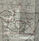
Now, turn the map up side down flipping it around, and we have the left half side of the map which shows were is the mine in regards to the triangle we will draw connecting the short lines depicted on the map, using as the peak of the triangle, the small triangle above the mine. I connected those lines for you in regards to see the shape of the triangle which has been created. The two lines below the triangle are the top of the dam, so we have the triangle at the location which was shown in the first map. Also the rays of the rising sun are touching the triangle so we are on the easterly side of the range looking to the west. From what you have understood, the map as you are looking at it in the first place, has orientation to the true east.
Now, search for the line which cuts the triangle, at a tenth of the dams lenght from the left, and search from the other lines in regards to create the triangle on the ground. While you have finished to create the triangle on the ground , go to the spot of the small cicle and you will find the spot of the mine.

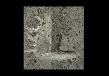
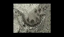
Something about the name of the map, LUE. After doing my research , I came to the conclusion the map maker used the shapes of the two dams they made in the region, and the letter " E " which is for the Spanish word " ESTE " ( east ). Those dams are hand made by scraching the soil around them, but for the " L " dam I believe they used and tailings from the mine, because is bigger and higher than the " U " dam. I will post aerial images of the dams. Maybe the dams were made to provide water for their livestock and for another pourposes. Also the half initial side of the map ( that with the east on top ), prompts us to use the " L " dam, and this could be concluded from the wall which is not curved and if you remove the arrow from the lines which go to the right, the half middle column with the rest of the lines to the right without the arrow, resembles an " L ".

Now, I will post the map with the invisible triangle drewn, and the aerial images of the dams, and how the invisible triangle on the map fits to the region of the dam, and the lines of the invisible triangle in regards to the " L " dam. I hope in the last image to distinguish the small circle at the spot is depicted on the map.
Enjoy and have a nice weekend
 

Attachments

  • Map-The-LUE-Map.jpg
    Map-The-LUE-Map.jpg
    502.6 KB · Views: 48
  • L.png
    L.png
    229.5 KB · Views: 48
  • U.png
    U.png
    90.5 KB · Views: 47
  • LUE2.png
    LUE2.png
    413.8 KB · Views: 49
  • LUE.png
    LUE.png
    400 KB · Views: 53
Last edited:
(#5) The LUE was a joke concocted by a prolific treasure writer who was demonstrating the utter gullibility of get-rich-quick wannabes.
Hey Steve, this is a true option but you have started with the end of the story.

In the beginning every person who get a map to treasure from a first hand source, do a research secretly in a region he believes the map belongs. After a period of time of research without any result, tells to his closest and trusted friend/s about the map, in regards to get help of ideas as what the map represents. After searching together for the treasure and didn't be able to find anything, the owner of the map take the decision to make it public, in hope to make some grands out of it by writing a book or by selling it. At least he will get something.
This is the way all the treasure hunters did after giving up on their research. And of course we are thankful to them for their decisions. Of how many maps we would be aware if their owners wouldn't make them public?
The maps are not fakes because their owners can't understand them, or because nobody else was able to find anything out of them.
The treasure maps are an art in their domain, and only someone who has the knowledge of this art can understand their meaning and if they are fake or accurate.
 

Last edited:
Hi. I for one, am not familiar with these stories. I would really enjoy any details your able to share.
Thanks, Markmar. What I was asking about though was the stories you mentioned about Wille Daughitt and Doc Noss. Can you expand on your statement made about them finding @ least part of the LUE?
 

Thanks, Markmar. What I was asking about though was the stories you mentioned about Wille Daughitt and Doc Noss. Can you expand on your statement made about them finding @ least part of the LUE?
Hi point hunter.
I wrote about Willie and Noss, because they were the only people who claimed finding treasure in the region of the LUE, always IMHO. I wouldn't say where this region is , because is well known and it wouldn't need more explanation.
In the same direction with the "L" dam and close by is a round water tank, which together with the shape of the dam , in Doc Noss imagination made it look like a " train station ".
I believe I gave enough clues in regards to this treasure. Read about Willie Daughitt story and it will put you very close.
 

With all due respects Mr. Brewer you are wrong about the L U E map and its location.

Regards

LUE-Hawn
Mr. LUE-Hawn,
I don't know your abilities or experience with the region of the LUE. My wife and I began our field work on the LUE in 1995. Our office manage posted some of our work on that and later I too said some things about it.
There are many treasures in America and elsewhere which are very similar to the LUE. However, of all those treasures depositories the only one ever marked as the LUE is the one we call the LUE. If you don't agree with our statements please post some of your evidence of the LUE. I mean something with the name LUE written on it. We have such evidence. One day you will see we are correct in what was said.
Kind Regards,
HBBB
 

The Ashkanazis in particular, who are not Semitic but adopted Judaism for political purposes many centuries ago. They are the "name stealers" described in the ancient Oera Linda Book, which itself was "discredited" by them. They are the ones who established and own the world's central banks and most of the world's political leaders today. Question is: where does the "KGC" fit into all this?
sdcfia, any good resources you recommend I read regarding Ashkenazi Jews and their adoption of Judaism? What century did this occur and why? I take it Ashkenazi and the Khazar Jews are one and the same? Ty.
 

sdcfia, any good resources you recommend I read regarding Ashkenazi Jews and their adoption of Judaism? What century did this occur and why? I take it Ashkenazi and the Khazar Jews are one and the same? Ty.
Ty, check your private messages.
 

Me personally I have no iron in the fire with this treasure legend. I love reading about all treasure legends. They are all fascinating regardless of authenticy.

For me there is no clear Provence of the alleged treasure map. With questionable authenticity.

There has been a bewildering array of posts of various interpretations over the years. From the map being created by the Spanish, Jesuits. Freemasons,Aztec, Nazis and millionaires hiding gold from IRS. Even it being fake to distract other treasure hunters from other lost treasures. Although some of theories posted here on TNET are really quite clever.

But At the end of the day it is only a theory based on speculations that are based on the assumption that document is real to begin with?

A questionable doodle that is reported to be a treasure map from some person or persons unknown. Open to one million and one interpretations. Who created it? Which one is correct? If any?

How long is a piece of string? There can be one million and one answers. For me the real treasure from Lue is endless hours of passion people put in find answers to questions they can never solve or prove conclusively.

For me it for that reason it is one worst treasure legends to research. There are other legends. At least partly grounded in fact. The Lue is entirely based in realms of speculation. And always will be.

Crow
 

Last edited:

Top Member Reactions

Users who are viewing this thread

Back
Top