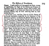
Lord Archibald Hamilton on 1715 fleet salvage...in Florida AND the Bahamas ?

We don't generally disagree. 8-)

The Gulf Stream being about 13 miles out from Miami and the channel about 58 miles there isn't much room to be that far away from either sets of danger.

The NC info doesn't count anymore than saying wrecks in the Bahamas proves the opposite.

Maybe the 1715 fleet sailed so close to the FL coast because of the 1656 debacle?
 

They also hugged the coast of FL because thats where the Gulf Stream is running. They gained an extra 2-3 knots speed in the GS which runs 5-10 miles offshore.
 

We don't generally disagree. 8-)

The Gulf Stream being about 13 miles out from Miami and the channel about 58 miles there isn't much room to be that far away from either sets of danger.

The NC info doesn't count anymore than saying wrecks in the Bahamas proves the opposite.

Maybe the 1715 fleet sailed so close to the FL coast because of the 1656 debacle?


Your reference to the Maravilla got me thinking a little bit. It is clear from survivors accounts the Spanish pilots were using Dead Reckoning on that occasion.


El Griffon broke away from the main 1715 fleet approximately 2 days before the hurricane hit in full force. She missed the storm more or less completely.

Apparently, two of Echeverz's vessels also broke away from the main convoy...one the day before the storm, the other the day of the storm. They could only have headed NNE or NE given their approximate position.

There is, IMHO, pretty convincing evidence the 1715 hurricane was north of the main fleet and travelling more or less due west: http://www.treasurenet.com/forums/s...-fleet-vessels-their-own-offical-records.html


The two ships of Echeverz that deserted the main convoy would have been well east of the main flota when the hurricane struck. Actually, because they had veered east, they would have met the fury of the storm before the main fleet. This is important, because they would have been considerably further south as well.


The missing ships of Echeverz's convoy would have been driven west and south by the storm, just as the main fleet ships were. But there is a difference:

The main fleet was driven west and south into the Florida reefs and sunk. When the winds shifted to the north and then the west after the passage of the storm, these ships could not be blown anywhere. They were already sunk.

But the missing ship's of Echeverz's convoy were much farther east when the storm began. And further south. They were not blown into the Florida reefs. Because they were on the open sea, they almost certainly would have survived. They were probably dismasted, but more or less intact.

But when the eye of the hurricane moved west of them, these ship's were still afloat. They were driven east by the passing storm...directly into the little Bahama Bank.

These were the missing ships mentioned by Admiral Salmon.

These were the ships Lord Hamilton and Governor Spostwood were looking for.

This is why the Spanish Man of War was prowling the north Bahamas.


Disclaimer: the above is just a theory !!!
 

Last edited:
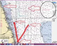
Here is a hypothetical scenario assuming Echeverz's ship or ships left the main flota at approximately 6 AM, Aug 30th. It assumes a forward speed of 3 knots for the main fleet and for the divergent ships. It assumes the divergent ships set a course of approximately 30 degrees when they separated from the main fleet. None of this need be precise, but the general situation is clear, as is the reason the possibility of ships grounding in the Bahamas exists.

The point of divergence off Lake Worth Inlet is 10 miles or so off shore...about the limit the Florida shoreline would have been visible to a lookout stationed aloft. It is roughly 72 NM south of Sebastian Inlet...it assumes the fleet averaged 3 knots per hour from the morning of Aug 30th to the morning of Aug 31st.


Hypothetical 1715 scenario.png
 

Last edited:
slight correction- it was July- but not really important8-)

I have to think of the rotation and positions. The wind set upon them from the NE when the Urca de Lima was at 28o latitude, and that is the ship that was reported as the most southern wreck, about 53 1/2 nautical miles away from where the storm hit them.

The Burmudans were very familiar with Spanish wrecks in the Bahamas. One of the ships salvaging the Maravillas was blown clear up to Bermuda in a storm that had scattered all the vessels working the wreck. They took in the crew of the disabled ship and heard tales of the large amounts of treasure still there. A group of them set out with the Spanish pilot as a "guest" to go work the Maravillas.

Do you think they sailed that close to shore? (please don't read that harshly it's an honest question) I always thought they sailed near mid-channel. Didn't it take those old ships something like 3-7 miles just to change tack?

Guess I should throw up that Internet disclaimer... no ill will in thoughts as type on the net can be misconstrued...just trying to learn and think of all angles!:icon_thumright:


Lordy, Please !!! Why would I tale offense to questions or corrections to my posts? That's what this forum is all about IMHO. I am no expert in any field and am just trying to learn. I am just bouncing ideas off the wall, really.

Anyway, obviously I meant July and not August in my last post. I kind of threw that map and post together on the fly.

As far as sailing distance from the coast, I absolutely believe the returning treasure fleets generally hugged the coast for a very long ways into the the Bahama Channel. Attempting to dead reckon all the way from Havana to Europe would be even more dangerous than hugging the coast. They would skirt the coast and look for a known landmark---probably generally one of the capes---Canaveral, Romain or one of the North Carolina capes, before turning wholesale to the east.

Obviously some captains and admirals had more brass than others. Some were more experienced than others.

I imagine the captain of The Griffin just decided to split from the fleet because he was faster and, after all, he had been compelled more or less by force to sail with the fleet to begin with.

As far as the Escheverz ships...it is tough to say why they left (if, in fact, they did). My guess is they smelled really foul weather knocking about and decided to save their own skins (and, quite probably, their own treasure).

I seem to remember in at least one of the survivor's accounts mention being made of a coastal observation or sounding being made when the weather turned foul that proved the fleet was very close in. I can't remember what exactly it was that was said.
 

My fault. Didn't mean to make Au_Dreamers (or anyone) gun-shy about posts.

I agree we're bouncing ideas. I have taken some comments too personally in the past apparently. No more.

Enjoying the discussion thoroughly. Learning lots.
 

Whoever finds one of the 1715's in the vicinity of Walker's Cay owes me a beer.

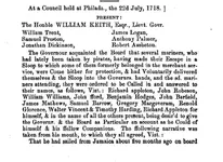
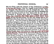
walker's cay 1.pngwalker's cay 2.pngColonial Records, 1717-1736

This document clearly references the 1715 fleet wrecks...note "to Go upon the Wrecks" and "the Florida Wrecks"...the tenor of this is unmistakable, as is the fact that Spanish shore batteries existed on the Treasure coast as late as 1718.

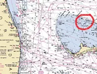
Here is a chart showing the location of Walker's Cay:

Walker's Cay chart.pngThe location is perfect. Perfect.
 

Last edited:
The sounding the 1715'ers took when the winds set upon them was approx 275-300ft water depth.

The Walker's Key reference could be about the Maravillas?:dontknow:

When they open up the Bahamas maybe we'll find out!

Nah Tammy it's just part of doing serious things on the internet:icon_thumright:

Hahah John, you know it, not afraid of guns and shooting straight!!:skullflag:
 

The sounding the 1715'ers took when the winds set upon them was approx 275-300ft water depth.

The Walker's Key reference could be about the Maravillas?:dontknow:

AHH---that was it !!! The main fleet was at approximately the 50 fathom curve...

The reference to Walker's Cay could be a reference to the Maravillas wreck...though the Maravillas wreck is 35NM or so from Walker's Cay...

Whatever wreck these chaps were working on doesn't seem to have been a "normal" wreck...

Three weeks is a long time to work a "normal" wreck and come up dry.

And there was another ship attempting to salvage the same vessel...
 

Capt. Charles Johnson, in his General History of the Pyrates, mentions that in 1717, Blackbeard stopped by "the Bahamas Wrecks" on his voyage from Grand Cayman up the east coast. I think most people have assumed "the Bahamas Wrecks" were meant as the wrecks on the Florida coast, but who can say?
 

Apparently, Walker's Cay was a popular place back "in the day".
Lots of wrecks in the vicinity.
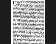
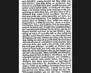
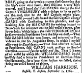
Here is an interesting one from 1764...I don't know if they got all the money, but it is hard to imagine getting a better idea of a sunken ship's location through a newspaper account.

bella, page 1.pngbella, page 2.pngbella, page 3.png
 

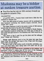
Maybe Jolly Mon is on to something.......:dontknow:

1715 wreck bahamas.jpg
 

Maybe Jolly Mon is on to something.......:dontknow:


I would guess the auction house president just misspoke here, but who knows?

Wouldn't it be a hoot if Dell was right and the "Material Girl" is sporting some of the Queens Jewels ??...sounds like one hell of a brooch...

(Absolutely no offense meant, Dell).
 

1715 bahamas oldmixon.pngFrom The British Empire in America, J. Oldmixon, 1761
 

Bahamaspress.com » American arrested after being suspected of looting sunken Spanish Galleon in Bahamas

I completely missed this story first time around...but I don't think it would have made much of an impression at the time anyway.

Someone revived an old thread with the story link: http://www.treasurenet.com/forums/s...merican-arrested-looting-spanish-galleon.html

This guy was not running a sophisticated operation (apparently complete with an airplane to smuggle out the loot) for Maravillas scraps.

Check out the story location...
 

the Spanish Valle knew because of the capture of an English balandra type trading vessel (Mari Galante ) off of portabella for "illegal trading" by Echeverz 's patache's * that the English Gov. Hamilton was corrupt ---the English ships capt. upon capture told tem that the vessel was 25% own by Gov. Hamilton (and was thus not to be "arrested" --it didn't work)--- so Valle knew that the british Gov. Hamilton doing illegal trading and was likely backing the raiders of the 1715 fleet area with royal "commisons" to help cover their hides for a cut of the take .--the English prize was taken to Havana and was later on sold to Ubilla as a "personal" vessel patache for his fleet.
 

Top Member Reactions

Users who are viewing this thread

Back
Top