Legend of the Stone Maps

Joe:

What's "kinda not true" about it ?

Bob has very clearly stated in his letter to Greg that this is what he was told by the Deputy US Attorney at their office in Phoenix. That the Attorney General's Office had obtained the stone maps to have them analyzed by the FBI laboratory to see if they were recent fakes. Bob then spoke to the FBI agent, asking him a specific question....."what had they found in analyzing the stone maps"....and the agent replied "that they believed the maps were at least a hundred years old".

I read that as meaning the FBI HAD examined the maps, and that "they" (FBI) had come to a determination (belief) re: the minimum age of the maps.
You may of course, read and comprehend it differently.

Mike:

You had sent off an FOI request some time ago.....any luck with that ?

As it stands, the FBI's opinion does not make the maps "genuine".
But it does eliminate Travis and many others who's names have been floated by the rumor mill as being responsible for the stones.

Regards:SH.

Wayne,

Bob does not believe the FBI "examined", other than maybe looked at the Stone Maps. Everyone has seen the letter he sent to Greg, but he does not recall the conversation going the way Jim Hatt originally told the story. I believe the story gained a life of its own, far beyond what actually took place.

Further, I don't believe the FBI ever actually took possession of the maps for any reason. If they did, there would be a clear record of the transactions.

Take care,

Joe
 

It gets interesting.
Joseph L. Tumlinson (1811-1894), "Peg Leg" Tumlinson's father, served in Lockharts Company of Spies from Oct. - - Nov. 1839(?)

View attachment 1180744

barrittfamily.net


View attachment 1180721

texgenweb.org


"Tumlinson enrolled on September 28, 1835, as a private in Capt. Robert Coleman's company of rangers. He was discharged in November 1835. He reenlisted for the duration and served with the same company at the battle of Jancinto on April 21, 1836. He was discharged on July 1, 1836, and enlisted again on July 4, 1836, in Capt. William Scurlock's company, San Augustine County. He later transferred to Capt. Richard Hooper's company and was discharged from this service on October 13, 1836."

tshaonline.org

Makes you wonder what was up with Joseph as it appears he couldn't hold a job in the service for very long and multiple times. Honorable or dishonorable discharge ? Sorry for the derailment, back on course.
 

Hello Everyone,

Interesting dialogue. Not sure if anything has really been established up to now and not sure if anything can be. For example everyone can agree the maps have a troubled background. But who is to say the maps in the museum are the originals or if any maps that are produced as being originals really are.

Who knows maybe the Peralta Map being presented here as the map that was used to create the trail maps was an entirely different map to begin with. Perhaps their similarity in design was just that and nothing more.

Perhaps the trail maps and the H/P carving have nothing to do with each other. And a realistic solution to both places you in different parts of the range. The trail maps in the western portion and the H/P carving in the eastern. And last what about the latin heart. Really the way to solve the maps starts there.

At the end of the day examine everything and take no one`s word for anything. Conduct a simple experiment. Simply look at the trail maps and the H/P carving and remove everything you think you know about them from your reasoning and ask what is it I am really looking at? Perhaps you are looking at something very, very old and something that was created rather recently to hide that fact.


Starman
 

Edit - also, what's the deal with the photo you posted a few posts up. Where you are holding the horse stone. You get in a fight with photoshop?[/QUOTE]

For what its worth........There are at least two versions of the photo in question. One appears unedited and the other has been chopped. The chopped version appears to encircle the face of the stone and appears to have been enhanced for clarity. I find NO difference in the image itself as to the depiction, the only difference is as to the lighting and increased pixilation. Unfortunately Mike wasn't here for that discussion and I pursued it to satisfy my own curiosity. There is no smoking gun here, in my estimation. I am assuming Mike merely tried to intensify the image, not change it as to details.

That's my take on it. Nothing nefarious here.
 

...............snip.........
Perhaps the trail maps and the H/P carving have nothing to do with each other. And a realistic solution to both places you in different parts of the range. The trail maps in the western portion and the H/P carving in the eastern. And last what about the latin heart. Really the way to solve the maps starts there.

Starman, In this we agree. I too think they relate to different areas of the range. I leave the Latin heart to others to solve. Its far too complicated for me.

Whether or not the TS and the HP map are newer creations or earlier???? I can not say. But their relation to the range(s) is more than just a coincidence.

Elaborate hoax??? Maybe, even probably. But; time and again, gold in quantity and quality has been found and continues to be found right where the maps say it should be.
 

Makes you wonder what was up with Joseph as it appears he couldn't hold a job in the service for very long and multiple times. Honorable or dishonorable discharge ? Sorry for the derailment, back on course.

Excellent observation. He received a pension and you are hardly derailing this thread.
 

More likely due to a rebroadcast of the "Legends" series on H2 this weekend, than anything within the discussion.

You are correct Wayne. Everything jumped. Plus it just hit Europe
ImageUploadedByTreasureNet.com1435590048.630170.jpg
 

You are correct Wayne. Everything jumped. Plus it just hit Europe
View attachment 1180822

Actually, the tread was kinda flat until post #345 Sunday morning. Then 700+ quick hits in a day.
I think that it was the content posted but in reality, who can compete with moving pictures that talk.
You may be correct.

This morning your at 20,399. Thats up 1000 since yesterday morning.
Lets see where it goes.
 

Last edited:
Folks,

I just made another discovery in my quest for answers too Travis Tumlinson's famous Peralta Stone Maps Treasures.


Just wanted to post the highlight of my trip to the area of the stone maps discovery (Sunday 6/28/2015)

What I discovered was not Bronze or Copper as it looked from a distance. It ended up being an old wooden Cross dating back as far as Travis's timeline. At first all I saw was the cross in a pile of rocks. Then I went around the back of it!
Low and behold it was a circle of stones attached to the Cross.

You can see the spot where Travis found the Stone Maps by the new highway and Queen Creek Bridge but you can't be seen from the discovery site of the Stone Maps at this spot. Sounds just like the old Lost Dutchman's Mine.

Is it a coincidence that a cross would be erected far away from the graves dug near where Travis is said to have discovered the stone maps?
Why a circle of stones attached to the cross? Why is Travis's boots lying near the grave or are they just some old boots from another Treasure hunter? Are the boots an indicator telling us to travel in a certain direction from the circle and cross?

The old white washed wooden cross had long since lost it's luster and I thought any trace of whom it had been erected for was long gone, that is, until I went and attempted to pull the cross up a bit for a better look at the base and discovered something totally unexpected and incredible!

Now we have two locations that are tied together one the first location Travis said he found the Stone Maps and two the second location to be announced when the Video comes out.


The Circle of stones attached to this Cross was a real "Clue" that something was up!

The very old boots another.

Then I found it, his name, right on top the old wood cross! I have a video of the entire discovery it may take me a while to upload the file as it's a very long Video and my DSL connection is not that fast but the Video is coming of this amazing find that may just hold the keys to the stone maps secrets.

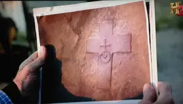
Could this be the Cross depicted on the Stone Maps that Travis discovered? Is this the starting point for the Trail to Treasures of the Peralta Stone Maps? Why was Travis here and why would he erect a circle of stones emanating from a wooden Cross?

Only an investigation of this find will tell the true tale of why he choose this spot to leave his clues and part of his legacy for some other experienced professional Treasure Hunter with the desire and will to brave the heat of the Arizona Deserts and go where no one ever thought of looking for The Secrets of the Peralta Stone Maps.


View attachment 1180819
 

What is sad is your use of their loss, publicly. ???


Anyway, welcome back Mike.
Hal this is out of line. I remind all posting of our rules.


"If you disagree with another member's post, make your comments in a polite and respectful manner."
 

Folks,

I just made another discovery in my quest for answers too Travis Tumlinson's famous Peralta Stone Maps Treasures.


Just wanted to post the highlight of my trip to the area of the stone maps discovery (Sunday 6/28/2015)

What I discovered was not Bronze or Copper as it looked from a distance. It ended up being an old wooden Cross dating back as far as Travis's timeline. At first all I saw was the cross in a pile of rocks. Then I went around the back of it!
Low and behold it was a circle of stones attached to the Cross.

You can see the spot where Travis found the Stone Maps by the new highway and Queen Creek Bridge but you can't be seen from the discovery site of the Stone Maps at this spot. Sounds just like the old Lost Dutchman's Mine.

Is it a coincidence that a cross would be erected far away from the graves dug near where Travis is said to have discovered the stone maps?
Why a circle of stones attached to the cross? Why is Travis's boots lying near the grave or are they just some old boots from another Treasure hunter? Are the boots an indicator telling us to travel in a certain direction from the circle and cross?

The old white washed wooden cross had long since lost it's luster and I thought any trace of whom it had been erected for was long gone, that is, until I went and attempted to pull the cross up a bit for a better look at the base and discovered something totally unexpected and incredible!

Now we have two locations that are tied together one the first location Travis said he found the Stone Maps and two the second location to be announced when the Video comes out.


The Circle of stones attached to this Cross was a real "Clue" that something was up!

The very old boots another.

Then I found it, his name, right on top the old wood cross! I have a video of the entire discovery it may take me a while to upload the file as it's a very long Video and my DSL connection is not that fast but the Video is coming of this amazing find that may just hold the keys to the stone maps secrets.

Could this be the Cross depicted on the Stone Maps that Travis discovered? Is this the starting point for the Trail to Treasures of the Peralta Stone Maps? Why was Travis here and why would he erect a circle of stones emanating from a wooden Cross?

Only an investigation of this find will tell the true tale of why he choose this spot to leave his clues and part of his legacy for some other experienced professional Treasure Hunter with the desire and will to brave the heat of the Arizona Deserts and go where no one ever thought of looking for The Secrets of the Peralta Stone Maps.


View attachment 1180819

ImageUploadedByTreasureNet.com1435591845.952854.jpg

You outdid yourself Bill. You found Tumlinson's cross.
 

Hal this is out of line. I remind all posting of our rules.


"If you disagree with another member's post, make your comments in a polite and respectful manner."

Point made/taken.
Correction: I find the sentence highlighted to be disingenuous (?) and retract the offending post.
 

Applies to all...


"If you disagree with another member's post, make your comments in a polite and respectful manner."
 

Wayne,

Bob does not believe the FBI "examined", other than maybe looked at the Stone Maps. Everyone has seen the letter he sent to Greg, but he does not recall the conversation going the way Jim Hatt originally told the story. I believe the story gained a life of its own, far beyond what actually took place.

Further, I don't believe the FBI ever actually took possession of the maps for any reason. If they did, there would be a clear record of the transactions.

Take care,

Joe

These "PSM analysis" arguments are only hearsay with an agenda until full documentation of said analyses are provided. The FBI allegations seem little more than whiskey talk.

Dating rock carvings is anything but an accepted science - in fact, it's a contentious subject in that niche of academia (forensic geologists, archaeologists, anthropologists, et al). Many geotech scientists will resist providing hard answers on specific dating of petroglyphs, preferring to defer to the pointy-heads' cultural benchmarks - style, language, subject matter, comparables, etc. - in order to attempt to narrow the age range.

sd,

I don't have any "agenda", other than passing along the information that Bob Corbin gave to me. Folks can make of it what they will.

Good luck,

Joe Ribaudo
 

Starman, In this we agree. I too think they relate to different areas of the range. I leave the Latin heart to others to solve. Its far too complicated for me.

Whether or not the TS and the HP map are newer creations or earlier???? I can not say. But their relation to the range(s) is more than just a coincidence.
Elaborate hoax??? Maybe, even probably. But; time and again, gold in quantity and quality has been found and continues to be found right where the maps say it should be.

lynda...i have seen quite a bit of gold that came from the superstitions..both inside the wilderness and out...but never have i seen where the stone maps have lead anyone to gold
 

Ryan,

I shoot everything in RAW Format. IF you would like a copy of that same or one of several others of me holding The Horse/Priest Stone, I will be happy to give you..... or maybe if you think I Photoshopped it, you can ask Greg Davis at the Museum (who gave permission for everything I did that day), or maybe Phil Reinhart (who actually took the picture). You don't know much about Adobe PS if you honestly think I Photoshopped it. I have almost 8 gigabytes of Stone Maps Pics taken that day in June of 2010 (and I don't lie).

.....and if you don't think a Schedule B Oil Service for a 12 cylinder Mercedes is less than $400, then you don't know as much as you think you do. At about $12 per quart, your 12 cylinder uses about 9.5 quarts. That is about $120 just in oil. You are supposed to use a fleece filter (not paper), about $15......and don't forget that Mercedes Labor Rates go anywhere from $120-$160 per hour. Then your cabin air filters. I have been in the auto business for over twenty years here in L.A. I was Internet Sales Director at Rusnak Mercedes in Arcadia, CA. I was not wrong. Maybe labor rates and pricing are different in SoAz, but in SoCal that is what things cost.

Joe,

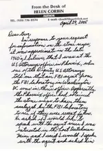
Why don't we just go to the horse's mouth on this one:

Bob1.jpeg
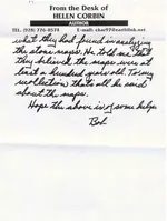
Bob2.jpeg
Dear Greg,
In response to your request for information on the Stone Maps, it was approximate in the late 1960's, I believe, that I was at the US Attorney's Office in Phoenix, when one of the Deputy US Attorneys told me that an FBI Agent from the FBI Laboratory in Washington DC was in their office. Apparently, the Phoenix Office had obtained the stone maps to have them analyzed by the FBI Laboratory to see if they were recent fakes. He asked if I would like to speak with the agent since I was interested in the Lost Dutchman Mine and I said I would. I spoke with the agent and asked him what they had found in analyzing the stone maps. He told me that they believed the maps were at least a hundred years old. To my recollection, that's all he said about the maps.
Hope the above is of some help,
Bob

Directly from Bob Corbin. Very simple. You seem to have added a few things to what Bob actually said. Nothing extraneous:

1. The FBI Agent was from the FBI Lab in Washington DC
2. The FBI Agent that worked at the DC Lab told Bob when asked that "they (they being the FBI) believed the maps were at least a hundred years old (in the late 1960s)"

You also say that you don't believe the FBI ever had possession of the Stone Maps. Bob Corbin's Statement seems to completely go against your thoughts on the subject, as he SPECIFICALLY states that the stone maps were examined by the FBI Lab in DC. As for your idea that there would be a clear record of the transaction is far from the truth. If you remember, I was the one that spoke with the FBI Agent/Historian John Fox PhD in D.C. His email response to our phone conversation:

I am sure we had paperwork, but whether it is around 40 years later depends on a lot of things. Lab paperwork and field paperwork was not kept like HQ paper was.

John

In our phone conversation, he also told me that if an investigation/examination shows no evidence of wrongdoing, there would be no reason for the lab to hold on to the files. If the stone maps would have been recent fakes, a criminal investigation would have been called for, and all the examination paperwork would have been required to be kept for possible use in prosecution.

So, if the FBI believed the Stone Maps to have been at least a hundred years old in the late 1960s, that would have predated even Baron Reavis.

Mike
 

Last edited:

Top Member Reactions

Users who are viewing this thread

Back
Top