JESUIT TREASURES - ARE THEY REAL?

The Kaminal Juyú Stela
Mayan Stele Throne.JPG
There is 6 Alligator (Cipactli) and just below on row 5 is 10 Rabbit (Toxtli). These dates compute to 13 January 147 BC Julian, 7.10.9.11.1 Long Count, 6 Alligator 4 Yaxkin; and 9 June 147 BC Julian, 7.10.10.0.8, 10 Rabbit, 11 Yaxkin. The 6 Alligator and 10 Rabbit dates repeat every 260 days. There are two more date glyphs in positions C7 and D7. This date is more obtuse. The lower half of position D7 is the day glyph Wind. No date number is apparent so it could be assumed that it is 1 Wind. That would be the date 21 October 147 BC Julian, 7.10.10.7.2 Long Count, 1Wind, 0 Sip. The upper glyph in position D7 is the knotted cloth glyph so someone is acceding to the throne. Could this be the earliest glyphic evidence to date of the Long Count notation in Mesoamerica?
The two date glyphs, 6 Alligator and 10 Rabbit written in the Nahuatl style not the Maya style. Following these two dates are two glyphs which translate to “death arrived.” After the two deaths by fire, there is the accession symbol. The glyph below the accession glyph is the date 1 Wind which is modified by the winal glyph to the left to become the 8 Wind glyph. Starting with the acceding event, the glyphs in positions D8 and C8 mean “first born son.” In Maya tradition, the next king is selected by primogenitary – the first born male closest to the king that is passing on. Then we have Le-ma-hi which we would call Limhi.
Land of Nephi: Every king needs a land – Limhi’s was Nephi, before they fled back to the Zarahemla area with rescuer Ammon and settled in Ammonihah. Nahua is the Nahuatl word meaning the number four. Nahua is Nephi in the Nahuatl language (Nephite language). Nephi was Lehi’s fourth son. Among the Quiché it is Nihai
Here we have an example of Mayans writing in Nahuatl in 147 B.C.
 

Last edited:
Was looking at my recent photos and thought these would be relevant to the subject thread.
Indian council Rio Del Oro and broken Heart.jpgSkull jesuit.jpg
First is my Indian Guides and the Broken heart in the Rio Del Oro.(is this the "Lost Dutchman?") Second was early in the morning and not very light but to the left of the skull looks to be the Jesuit Mark in a circle?
 

Last edited:
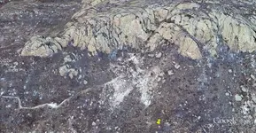
Here is a current picture of the Virgen de Guadalupe/Tumacacori Mine site at Camp Loco. You are looking West. The old cart road ends at the "corte" at the front of the mine entrance. (Click on picture for enlarged view.)
 

Attachments

  • Virgen.jpg
    Virgen.jpg
    280.6 KB · Views: 142
Last edited:
It looks like its kimberlite a good spot to find Diamonds.
Kimberlite.jpg
Hope for the best at Camp Loco!, I wish you the treasures you seek! The problem is that diamonds can not be found with metal detectors. Look for rounded metallic looking rocks with pinwheels on them.
 

Last edited:
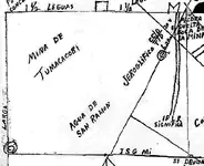
The map that I posted of the Virgen de Guadalupe/ Tumacacori Mine is actually 5 maps in one. The box in the upper left corner is what I call map#1. The top of this box is North with the mine at the top. The cart road comes in from the South. The monument is to the West of the cart road, 200 varas from the mine entrance. At the top of the map is a caption in Spanish that reads "loose rock at the mouth of the mine." This is the tailing pile that has spilled down the hill from the "corte" in front of the mine. Notice what appears to be an "M" at the top of the map. This is not a letter, but it refers to the two peaks that were blown down over the entrance to the mine. Lower in the box there is a point where lines cross with a title of "Agua de San Ramon." These lines are not part of map#1, but they are there to show the relative distances to the points listed on the map's edge.

Some other important items on other portions of the map are the cross and the face on the cliff, and the monument to the Virgen de Guadalupe. I do not know if the CCD black monument is still at the site. Some say it was just pushed over by Mrs Shepley when she dug for treasure during the years 1932 to 1939.

From where did this map come? It matches the mine site 100%. Was it part of the Molina Derretero? I don't think so. Was this the map that was given to Judge Barnes? I don't know. In my opinion, there was some religious activity at this site. The small mission building, the cross on the cliff along with a face that appears to be of Christ, and the ruins of of other buildings lead me to think that this site was very important. It is possible that this location became a storage and supply center for the Northern missions. Was this location active during the Franciscan period leading up to 1648? Was this a Jesuit project? Who were the Padres of San Ramon? Was this site operated after 1767? The Jesuits kept excellent records, and yet this site does not seem to be mentioned. If it was referred to in Jesuit diaries, the location and activities here were definitely kept secret.
 

Attachments

  • map1.jpg
    map1.jpg
    100.9 KB · Views: 132
[h=2]"CORTE shape[/h]
Hi lgadbois

I believe the " CORTE " in the Tumacacori map is the land shape at
31*33'30''N and 111*04'36''W
The map has the east on top .

Marius"

Your map interpretation is incorrect. Most of your questions are answered in Gary Don Oliver's book, "Enigma at Tumacacori." The "Corte" is an area that was leveled at the mouth to the mine. Gary has done a good job of mapping the site in his book.


"CORTE shape

Hi lgadbois

I believe the " CORTE " in the Tumacacori map is the land shape at
31*33'30''N and 111*04'36''W
The map has the east on top .

Marius"

Your map interpretation is incorrect. Most of your questions are answered in Gary Don Oliver's book, "Enigma at Tumacacori." The "Corte" is an area that was leveled at the mouth to the mine. Gary has done a good job of mapping the site in his book.


Oh lgadbois

You have shared my PM . Why ? Is this a treasure hunter habit ? I am disappointed .
 

lgadbois are you pursuing a location that has produced nothing for all the thousands of dollars that were spent on the site? not to mention the years of fruitless digging? It could well be what others thought it was but could not also. Yet I have found a site that can show to match also and can show the matches along with a huge fault zone that cross quartz Diabase and has most of the needed events to produce what would be expected. is this the Hieroglyphic and the Memorial?mina virgon numbers.PNG
I know a geologist could tell you what may have been processed there years ago by mineral samples from the tunnel site. I do remember that the geologist that worked for the local mines back then told Mrs Shepley that she was wasting her time and that the site could not produce gold. How ever i have not seen any actual geological samples that have been analyzed from the site. Keep us posted with your results.
 

Pay attention to every little detail in this photo, even though slightly blurry... you can still see.

Look Closely at the Saguaro

what you assume it is, you are correct


The Jesuits were not known for marking cacti.

And even if they did, the cactus they marked would have to be at least 3-400 years old, since they only grow an inch a year after two feet of growth and would have had to grow tall enough by the time the Jesuits got here. That doesn't look like a 400 year old saguaro to me.

Also, there's quite a bit of artifacting in your pictures which means you intentionally manipulated them in post. Doesn't help when you do that.

I don't care who marked it, I was just saying to take a look at the saguaro
 

I don't care who marked it, I was just saying to take a look at the saguaro

I understand, but you posted that picture in this thread which makes me assume that you believe that something on the saguaro is Jesuit-related.

And as I pointed out, that saguaro would have had to be around 3-400 years old, with a lot of growth.

For comparison purposes, here is a picture of an authentic 300 year old saguaro in front of the Loews Ventana Canyon hotel in Tucson, AZ:

loews-ventana-canyon.jpg
 

I understand, but you posted that picture in this thread which makes me assume that you believe that something on the saguaro is Jesuit-related.

And as I pointed out, that saguaro would have had to be around 3-400 years old, with a lot of growth.

For comparison purposes, here is a picture of an authentic 300 year old saguaro in front of the Loews Ventana Canyon hotel in Tucson, AZ:

View attachment 1017046

I didn't show the rest of the saguaro as it is very large, I didn't want to give off the location... so I just wanted to show the lower part of it to protect it from vandals and what not.
 

John,

Where can the picture of your cactus be found?

Thanks,

Joe Ribaudo

I was just jumping back and forth looking for the same thing. HAHAHA At least I am not the only one.

Mike
 

Top Member Reactions

Users who are viewing this thread

Back
Top