markmar
Silver Member
- Joined
- Oct 17, 2012
- Messages
- 4,278
- Reaction score
- 6,511
- Golden Thread
- 0
- Primary Interest:
- All Treasure Hunting
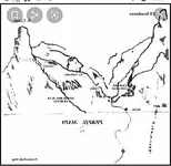
This is the perfil map area. It's not where you are talking about. Map is actually 3D. Got to bend it at the middle creek ravine. My question has anyone that already knows this been there? Not what I'm looking for , so no I haven't spent the time to.climb there myself tho. Even if this is one of the easiest to get to of all the maps of mines in th sups. Perfil map is Not of the Ldm.. In the giving mood today, for those that don't know of the area yet.


Hello Doc
In my picture above, I was mentioned only the "face" which is depicted on the Perfil mapa and not the entire map's landmarks/region.
Now, if you believe a treasure Spanish/Mexican map would show the shape of a peak different than what could be seen in the field, then you are way afar from the real deal.
You are right the Perfil mapa is a 3D map, but what you maybe don't know is the perfil mapa is a multidimensinal map, which has different scale/distance for the edges of the map and a different scale for the centre. So, you have to recognize first the image of the egdes and after to go closer to see the centre.
The Spanish/Mexicans map makers, if would draw a specific shape of a landmark, then you have to look for the exact shape in regards to the other landmarks depicted in the map, and nothing different like a spire or a sharp peak that would fit your area of interest. i believe also you know the Perfil mapa should be reversed/mirrored because the feathered arrow symbol that it has depicted on.
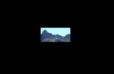
I post a crop of a real picture, to see the real S.Cima and beside a part of the landmarks depicted in the Perfil mapa. I reversed the Perfil mapa for better understanding. Enjoy
Amazon Forum Fav 👍


Attachments
Last edited:


")

