Detailed route to Adams gold

sdcfia, Very impressed with what you've "dug up" so to say, about this. Instead of going willy nilly into the haystack looking for the needle, you are doing the homework needed to centralize the spot. As many have found, or not so, you can take a "treasure map" and/or story out in that country and find a thousand places that all match most of the listed spots.

And just a thought as to the Fort names. I had mentioned this elsewhere here, when giving directions to someone, you use the current info.
For me to tell someone today to look for Kippy's barn, they wouldn't have a clue what I was talking about. But if when giving directions, I would say look for the Svonavec's burned out foundation, they would easily know what I'm talking about.

As stories get intermixed the names of places in them can also get screwed up. So Ft. so and so, that was located 50 miles down the road, became Ft. such and such years later when it moved. So when someone talks about it, you need to know are they talking about the original location, and/or name, for the time frame.

I would tend to think a lot of authors get caught in this trap. They get their info, and with it a little old and a little new, and they put two and two together and come up with five, instead of three. And Joe Schmoe reads the book, taking it as gospel, and we have another body out in the mountains.
 

King Solomon's Treasure is in the area

May I ask what led you to conclude this? Can you provide some evidence to support this contention? Thanks in advance;

Steve - great posts, hope you are not done yet! (Keep 'em comin!) Two thumbs up!

Coffee anyone?

:coffee2: :coffee2: :coffee:
 

May I ask what led you to conclude this? Can you provide some evidence to support this contention? Thanks in advance;

Steve - great posts, hope you are not done yet! (Keep 'em comin!) Two thumbs up!

Coffee anyone?

:coffee2: :coffee2: :coffee:

All monuments, symbols, entrances, death traps ect. have been located. It's a site we plan on getting back to and finally opening up. I can't give much more than that at this time.
 

May I ask what led you to conclude this? Can you provide some evidence to support this contention? Thanks in advance;

Steve - great posts, hope you are not done yet! (Keep 'em comin!) Two thumbs up!

Coffee anyone?

:coffee2: :coffee2: :coffee:

Oro - thanks.
 

Unreconciled Pinos Altos gold legends

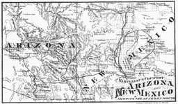
1. Mangas Coloradas’ secret gold mine. Samuel Cozzens traveled extensively in New Mexico and Arizona beginning in 1858, observing much, including gold and gold mines in both states. His excellent memoir, The Marvelous Country, provides many details of his experiences, including a significant amount of time spent with the Apaches - he was a guest in the camps of both Cochise and Mangas Coloradas. Cozzens remarked, “I have myself seen pieces of gold in the possession of Apaches, weighing nearly half a pound, which they made but little account of, being ready to exchange it for any trifle that struck their fancy”. During his stay with Mangas, Cozzens reported the following: “I spent the greater portion of the day in strolling about the rancheria, visiting the huts and conversing with those who understood Spanish. From them I gathered some information, concerning the surrounding country. I ascertained that the village contained not far from seven hundred inhabitants, and that the home of Mangus Colorado was situated nearly a league to the westward, where he lived, surrounded by about one hundred of his braves and their families. That no white man had ever visited the rancheria. That the country around abounded in game, and that large quantities of (oro) gold were to be found in the canons and gulches about five leagues to the north of them.”

Referring to the topo map displayed in Post #20, it is five leagues (13 miles) from Mangas Springs - Mangas’ rancheria - northeast to the “Bear Creek” label on the map. This is the midpoint of the Bear Creek placers, which is strong evidence confirming what the Apaches told Cozzens in 1858. This strongly supports this location as the source of the Adams party’s placer diggings, but it doesn’t help identify the rich gold lode alleged to also have existed in the area - another deposit that the Apaches were reported to have known about.

In The Marvelous Country, we are also told, “One Felix Aubrey, who explored the country quite extensively in 1849 and ’50, tells many marvelous stories of the quantities of gold which he found "near the head-waters of the Gila", and also of the "large amount then in possession of the Indians.” The Gila headwaters region is quite extensive and includes the Pinos Altos/Santa Rita vicinity in most early reports. It also includes the Mogollon Mountains - where some interesting gold legends exist - but we will focus on the Pinos Altos portion of the headwaters zone.

cozzens.jpg
Cozzens' 1858 route (The Marvelous Country, p 204)

During the US Boundary Survey’s expedition, according to John C. Cremony’s excellent Life Among the Apaches, the group camped for extended periods at Santa Rita del Cobre ca 1850 and had many encounters with Mangas’ Apache band. At that time, it was reported that a Mr. Hay(es) was operating a gold mine, “a few miles from the post.” Survey Commissioner John Russell Bartlett confirms the Hayes report in his notes. "A few miles from Santa Rita" offers several possibilities: Pinos Altos (eight miles distant), the Santa Clara early Spanish mines (three miles), or the Santa Rita Mine itself, which was very rich in gold in the early days. Although Mangas was undoubtedly aware of all these possibilities, in order to be in line with the LAD legends, we assume that the Pinos Altos vicinity was the rich lode location.

The takeaway here is that the occurrence of gold in quantity is, obviously, documented in the Bear Creek/Pinos Altos region, and has been known of by some Anglos since 1860 - if not ten years earlier. Mangas Coloradas and his strong force of Apaches were not only aware of the area's gold sources, but likely had been exploiting them themselves for many years prior to the Adams adventure. In addition, since we know that Anglo explorers became aware of the gold’s general locations at least as early as 1850 - particularly with Cozzens’ 1858 revelations - it seems likely that Jacob Snively may have had prior knowledge of the rich Bear Creek placers prior to his 1860 discovery of them. If so, he may also have had much more of a part to play in the Adams expedition of 1853 than that of the enigmatic "Dutchman".

It seems likely that Mangas Coloradas and his Apaches mined and traded Bear Creek placer gold themselves in the 1850s, possibly earlier. When a gold rush began at Bear Creek in 1860 - led by Jacob Snively, who discovered the deposit based on recently published reports - the Apaches drove the miners out within a year. When Snively returned in 1863 with the Adams party, Mangas' Apaches killed them all, save Snively, Adams and perhaps one or two more. We know the placers were reclaimed by Anglos ca 1864-66 and worked out by 1880. In future posts we will examine legends of "lost" lode deposits in the area that may tie in to the LAD legends.
 

Last edited:
Unreconciled Pinos Altos gold legends

2.
Big rock covers old Spanish gold mine shaft above Bear Creek

Not many people have heard the story of the lost mine “above Bear Creek” that has a large rock covering a small vertical shaft opening. I heard the tale from Tommy Donahue in the late 1970s. There were several genuine old prospectors living in the hills around Pinos Altos in those days and Tommy was one of the best known. These guys lived in the hills in old cabins and supported themselves by working small mines, collecting fine gold from their many well-positioned gold traps in small watercourses, and, in the late 70s, by staking and selling claims in the path of the Exxon Corporation, which was then busy grid-staking 2,000 claims in the district.

I wish Tommy was still around to refresh my memory, as I’m sure I’ve forgotten some of the details, but there weren’t many to begin with. Here is all I have:

The story’s origin was unknown, but allegedly dated to the Carrasco days at Santa Rita del Cobre and was a family tradition among certain Hispanic families in the region. A local folk tale of sorts, passed down through the generations. The mine was a short, narrow vertical shaft that followed a very rich outcropping of gold ore straight down from the ground surface. It was only a few feet away from the flow line of an arroyo-rill-creek-cañon on a large rock outcropping which crossed the creek and formed a drop-off below it - a “waterfall”, technically, I guess you could say. The small opening was hidden from view by a large flat rock that had been levered over it. During heavy enough rains, water would seep under the big rock and into the shaft. There were no dumps or waste rock nearby, as the waste was apparently just thrown into the creek to wash away, or hauled off and disposed of on the hillside.

Tommy was interested in the legend because it was so little known of or looked for. He was usually busy with other things, but on occasion would hike up certain creeks and watersheds looking for anything that might match the story. He figured that if the mine existed, it was most likely in one of the drainages emptying into Bear Creek from the Pinos Altos Mountain side. He said that he had checked Long Gulch, Rich Gulch and Arroyo Rico over the years without finding anything promising (see aerial view, Post #59). He admitted that there was no telling how big the “creek” was, how large the rock outcropping was that crossed the creek, how large the covering stone was, or how high the drop-off was below the mine. With that in mind, Tommy concluded that there might be a “thousand possibilities on that mountain.”

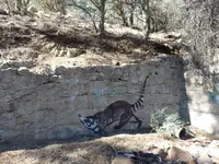
Was this lost mine legend the same place that the Apaches warned the Adams party to stay away from? We can't know, but if so, it would logically be lower rather than higher on the mountain, IMO. Tommy and his cabin are long gone. All that’s left is some graffiti on an old retaining wall he built years ago. Pretty nice graffiti though.

tommy.JPG
 

Last edited:
Really good, solid and interesting stuff, sdcfia.

I have been going through some old Chiricahua Apaches notes/books and information. It is notable that they had taboos against mining for gold but no such superstition for owning it.They also were 'permitted' to collect nuggets from dry riverbeds etc, for trade but would not agree to dig for it. It seems by the late 1870s whilst there was still large groups of Chiricahua on the warpath (Victorio, Juh, Geronimo et al), there was seeds of greed and dissension being sown when it came to caches of gold and silver. There was an ambush of a silver mule train from Casas Grandes in old Mexico and the Aoaches had to scarper quickly with their loot and there was serious disagreement about how to handle and store it.

The interviews with Apaches who were contemporary with the late 19th century in the Southwest are very interesting and informative, yes, but just because it was a Native telling the story is no guarantee that we can put total trust in what they said. Just like anyone else telling a story, Apaches had loyalties, secrets, agendas, insecurities and imperfect memories - especially when dealing with Anglos, whom they were known to mislead on many occasions.

We know the Apaches were trading gold with Anglos as early as the 1850s in the American Southwest, and even earlier in the Janos area of northern Mexico, where they had Mexican allies during the Apache Wars and maybe even later. I agree with you that there were different factions among the tribe that were split on many issues as the wars intensified - primarily whether or not to keep fighting. Whereas I feel that rumors of "secret Apache mine locations" are way overblown and mostly tall tales, I do believe that the Natives were smart people, and if they could gather or steal gold to trade for arms, ammunition and other supplies, it was a no-brainer that they would do it. The "Tears of Ussen" angle is noble, but when push comes to shove, all people who are threatened like the Apache were revert to, "Praise the Lord and pass the ammunition." If gold buys bullets, get gold.
 

Where and when did the Apache come from? How did they form? Are they as old as most other tribes?
 

There was a warrior from the last band of Geronimo's renegades of 1886, who went back into old Mexico during the 1930s to try and retrieve a cache of gold from a cave in Sonorous but was held by the Mexican authorities and returned to the Mescalero reservation due to not having sufficient identification.

Many people attempt to portray the Apaches with a 20th / 21st century mindset. They were just as sly, honest, devious, ingenious and practical as any human being would be in their environment and circumstances.

I also agree with your view on so-called "lost Apache mines".
 

The Apache Tribe was created/formed from radicals that left other tribes just like many other tribes around America. The Spanish also created tribes formed from radicals.
 

Unreconciled Pinos Altos gold legends

3.
Gold cache near Spanish fort ruins up Little Cherry Creek Canyon.

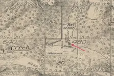
This little-known legend is a difficult one to find information on. Little Cherry Creek Ranch was one of Grant County NM’s first Homestead Patents. John Wright first filed his 160 acre claim May 20, 1862, in Section 21, T16S, R13W (see Forest Service map, Post #8). Access to the property is a crude two-track right up the bottom of Little Cherry Creek Canyon, and is still a challenge for the current landowners today. It’s remote. Below is a portion of a 1920 Township Survey showing the property - Wright’s house indicated.

LCC Ranch.jpg
Little Cherry Creek Ranch (GLO Township Plat)

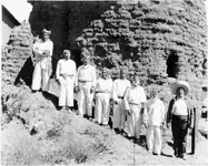
Wright built a stone house on the property in 1863. The house was used as a youth Scout camp in the 1950s, then improved by new owners in the 1960s. It’s still occupied today, improved again in the 1990s. Wright allegedly built on the ruins of an existing stone structure said to have originally been a Spanish Fort, ca 1800. If true, this structure would have pre-dated the Spanish triangular fort at Santa Rita del Cobre - seven miles southeast - which was built ca 1834, replacing a smaller cruder structure possibly constructed in the 18th Century. But why was a fort built in this remote location high in the mountains? In a future post, we will discuss the old Spanish gold mines at Twin Sisters Peaks, only a mile or so distant. With this information in mind, it seemed likely that Little Cherry Creek Ranch may have been a secure camp for miners working at Twin Sisters. We have no records to verify these speculations.

fort3.jpg
Corner circular torreon of Spanish fort, Santa Rita del Cobre, Oct 1916.

In February 1980, my partner and I received an unsolicited letter from a man in Wyoming offering us 70% of the proceeds of an alleged treasure trove if we were willing to obtain all necessary permits and do all the field work necessary to locate the cache, based on information he was providing. He claimed to have gotten his information “from the mouth of an old Indian”, who described an “Apache burial cave within five miles” of Little Cherry Creek Ranch that contained $5 million in Spanish gold coins or gold bullion taken from the Spanish. The man provided a crude map which was somewhat accurate in describing the terrain in question, but useless for the purpose.

We declined his offer but were still interested in the story - the first details we were aware of that gave any information at all about the alleged Spanish Fort. A five-mile radius with the ranch house as a starting point is eighty square miles of very rugged terrain in the Pinos Altos Range in which to search for a hidden cave - a daunting task that could take a lifetime. However, from this point forward, we had some intriguing new images of the area: a Spanish gold mine, an Apache ambush, a hidden cave of gold.

When the Adams party was warned by Apaches to stay away from the higher country above Bear Creek - where there was even a richer gold source than the placers - was the subject of the warning a cave full of gold?
 

Last edited:
Nobody wrote:
And Oro, I cannot join you in support of the beef industry, as I am a vegetarian and do not eat other mammals, but I always have enough coffee to go around

I have no issue with your personal preferences for your diet, however we as living beings survive on digesting other living things, plants and fishes etc may also be able to feel pain even though we do not commonly think of them in that way. Our teeth and digestive systems are designed to be omnivorous, not herbivorous, and flesh of animals is also nutrient-rich. Besides, vast areas of land in most countries are not suitable to growing of crops, (too little rain, soils too poor, rocky, swampy etc) but can provide forage for livestock and thus be converted into foods while also maintaining the lands and even enriching the soils through manure and keeping the vegetation from becoming overgrown resulting in terrible fires. Many of the fires in CA in recent years, are in areas where grazing of livestock formerly was very widespread, the animals kept the vegetation from getting too thick and then drying out to become tinder. Anyway not trying to change your diet, just thought I would explain there is some logic to the non-vegetarian method.

I must also respectfully disagree with several of your points posted, but would like to read more on the topic Lost Adams, and my apologies for the off-topic post. Please do continue. :notworthy: :notworthy: :notworthy: :thumbsup:

Coffee or tea anyone?

:coffee2::coffee2:
 

<cut> And that includes the LAD. sdcfia, what makes you believe there actually exists a patch of ground that at that time (ye 'ol KGC era) produced the placer gold purported? If some legitimacy to the story, how do you know it wasn't a message being sent concerning a cache recovery of placer gold mined somewhere, say a bit north of you in my part of the Rockies, cached en route to Mexico City for transport via ship to get the Templar bank accounts rollin'?

So much of this stuff is interrelated. And all it goes back to the Legend of the Kingdom of Prestor John, which probably should be called the Legend of the Kingdom of Quetzlcoatl. Prestor John was behind marching whom we refer to as the Anasazi on down to Mexico City to fire up the Aztec Civilization.

And Oro, I cannot join you in support of the beef industry, as I am a vegetarian and do not eat other mammals, but I always have enough coffee to go around ...

Sorry to sidetrack your thread, sdcfia, but I've been on the horns of a dilemma. For the last several months, I can't stop seeing New Mexico license plates everywhere I go. Like, multiple times every week, for months on end. It won't stop. I don't know why. Perhaps it is as simple as recent legislation in the High Country has caused a mass Exodus north. But in case it isn't that, I figured I'd better at least say a couple things in a New Mexico thread and chat with a couple neighbors to the South.

But, I do want to ask you that question - why do you believe ANYTHING about anything you have read/heard about the LAD to be factual, including there ever existing such a placer deposit for Adams to find? Most of what people point to as evidence are paper trails. Paper trails are very easy to create. They have created a great number of them over the course of the last few Centuries ...

I gotta get back to work on some tings ...

Good to hear from you again, Nobody. I'm not on the Fomenko bus yet, but I have been paying attention to Lindahl and others like him quite a bit lately.

Re the "Lost Adams Diggings" - what I've attempted to do in this thread so far is to identify the location of the action, once and for all. When I complete this task (almost done), I will then move on to other perhaps more interesting aspects surrounding the legend. But to answer your question - yes, I do believe certain parts of the LAD story. That was necessary for this coded message to be successful - there needed to be truthful information delivered. Now, was there a "monster placer deposit" waiting for the Adams party? Likely not of the reported magnitude, but there was good placer there, and that was an important characteristic helping to identify the location.

Later, I'd like to discuss why the LAD story was told, how the facts were manipulated, who the participants may have been, what that bunch of men was doing in AZ/NM, why this location was chosen, why we don't know their identities, why their bodies were never found, and other stuff like that. Oh, and what about Jacob Snively? Besides, I was getting tired of so many people continuing to insist the action was in the lava flow and thought I'd try to give some of them a nudge. Of course, many will cling to their prior favorite theories, but at least this thread is available for curious minds to tinker with.
 

Unreconciled Pinos Altos gold legends

4. Spanish mines on Twin Sisters Peaks


There are a number of legends indicating Spanish gold mines in the Pinos Altos/Santa Rita del Cobre mineralized zone. Historians date Spanish activity in the area to ca 1800, when Carrasco, Elguea and others began shipping native copper and other very high quality oxide ores to the Royal Mint in Chihuahua for coinage. However, military reports indicate regular patrolling of the area in the mid-1700s from the presidio at Janos, trying to control Apaches who were constantly terrorizing the miners. In the earlier days of the famous copper mine, very high gold values were also recovered from the oxide ores, and there are a separate set of lost mine/cache legends as a result - one of the most believable surfaced about fifteen years ago. For the purpose of this Lost Adams discussion, however, we will focus on Spanish mines on Twin Sisters Peaks - aka “dos piloncillos.”

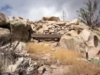
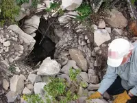
In the 1980s, a group known as Codebreaker Enterprises Inc. cleared a concealed and collapsed vertical shaft collar at a very old mine high on the east face of the north Twin Sister (TS1) and explored the workings inside. They recovered and privately displayed several artifacts that were arbitrarily dated to roughly the 1750-1800 era, the most impressive find being a “Spanish firearm”. This secretive organization revealed nothing more about what was found in the old mine, and then decided to collapse the collar again and reseal the entrance. Some years later, my exploration partner and I discovered a second, lower tunnel that presumably connected to the same workings, but we chose not to attempt an entry due to what we considered a severe safety risk. The opening - more like a gopher hole - was very small, in unstable ground with no support, and evidence of wall- and ceiling-collapse not far inside.

Upper shaft.JPG lowerTS1.JPG
Collapsed collar TS1 ..................................................Lower TS1 connecting tunnel

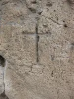
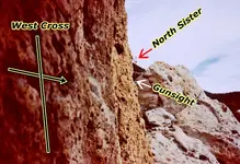
The sealed upper shaft of TS1 was allegedly located using a very weathered rock carving about a thousand feet away from the opening. The carving is a Christian cross on a pedestal, its right cross arm ending with an arrow pointing through a notch in the nearby rock directly to the mine.

El toro.JPG gunsight.jpg
Carved west cross ........................................TS1 mine pointer

Codebreaker Enterprises Inc. opened a second backfilled mine shaft on the north Twin Sister (TS2), also high on the mountain, this time an inclined shaft on the northwest face. Much backfill was removed in the 1990s. Nothing was said about what was found inside. I have no photos of the site, which was also later backfilled and abandoned, but reopened ca mid-2000s. No reports have been given on the second reopening.

A third backfilled mine opening (TS3) is located on the south face of the north Twin Sister, lower than the other two sites. It appears from the surface as if it is a horizontal opening, with its backfill significantly eroded. The tunnel has not been reopened to my knowledge.

Lower workings 1.JPG
TS3

The south Twin Sister has only one apparent old mine (TS4) visible on the mountain - a twenty-foot diameter pit about eight feet deep near the top of the mountain. No modern era work appears to have been done on this site. Codebreaker Enterprises Inc. possessed mining claims for only the three mines on the north Twin Sister for years. I don’t know if those claims are still current. My research indicates that neither the three mines on the north Twin Sister nor the one on the south had any prior mining locations filed in the Grant County Mining Location records. Presumably they were located and worked prior to the Anglo period.

There is solid evidence that three or four previously-worked and closed mine workings exist on Twin Sisters Peaks, and that circumstantial evidence provides a reasonable possibility that the sites likely date to a time before the Anglo era in the Pinos Altos vicinity (ca 1860) - perhaps a hundred years earlier, perhaps more. Could one or more of these old mines be the site that the Apaches warned the Adams party to stay away from in 1863, when the group was placer mining below in Bear Creek? We can’t know with the information that we have so far.

There are many rock carvings on Twin Sisters Peaks - some obviously modern graffiti from hikers, but many old and enigmatic. One of the latter is especially puzzling. The carving is very weathered and hard to find unless you know where to look. Below is a photo of it. It was necessary to chalk the lines in order for the faint message - whatever it means - to be visible. The word is “INDAH”. The style seems modern - likely not earlier than the late-19th century. The word in the Apache language means, “white people”. It’s unknown who carved it, when or why.

Indah chalked 2.JPG
INDAH
 

Last edited:
Unreconciled Pinos Altos gold legends

4. Spanish mines on Twin Sisters Peaks


There are a number of legends indicating Spanish gold mines in the Pinos Altos/Santa Rita del Cobre mineralized zone. Historians date Spanish activity in the area to ca 1800, when Carrasco, Elguea and others began shipping native copper and other very high quality oxide ores to the Royal Mint in Chihuahua for coinage. However, military reports indicate regular patrolling of the area in the mid-1700s from the presidio at Janos, trying to control Apaches who were constantly terrorizing the miners. In the earlier days of the famous copper mine, very high gold values were also recovered from the oxide ores, and there are a separate set of lost mine/cache legends as a result - one of the most believable surfaced about fifteen years ago. For the purpose of this Lost Adams discussion, however, we will focus on Spanish mines on Twin Sisters Peaks - aka “dos piloncillos.”

In the 1980s, a group known as Codebreaker Enterprises Inc. cleared a concealed and collapsed vertical shaft collar at a very old mine high on the east face of the north Twin Sister (TS1) and explored the workings inside. They recovered and privately displayed several artifacts that were arbitrarily dated to roughly the 1750-1800 era, the most impressive find being a “Spanish firearm”. This secretive organization revealed nothing more about what was found in the old mine, and then decided to collapse the collar again and reseal the entrance. Some years later, my exploration partner and I discovered a second, lower tunnel that presumably connected to the same workings, but we chose not to attempt an entry due to what we considered a severe safety risk. The opening - more like a gopher hole - was very small, in unstable ground with no support, and evidence of wall- and ceiling-collapse not far inside.

View attachment 1179743 View attachment 1179744
Collapsed collar TS1 ..................................................Lower TS1 connecting tunnel

The sealed upper shaft of TS1 was allegedly located using a very weathered rock carving about a thousand feet away from the opening. The carving is a Christian cross on a pedestal, its right cross arm ending with an arrow pointing through a notch in the nearby rock directly to the mine.

View attachment 1179745 View attachment 1179746
Carved west cross ........................................TS1 mine pointer

Codebreaker Enterprises Inc. opened a second backfilled mine shaft on the north Twin Sister (TS2), also high on the mountain, this time an inclined shaft on the northwest face. Much backfill was removed in the 1990s. Nothing was said about what was found inside. I have no photos of the site, which was also later backfilled and abandoned, but reopened ca mid-2000s. No reports have been given on the second reopening.

A third backfilled mine opening (TS3) is located on the south face of the north Twin Sister, lower than the other two sites. It appears from the surface as if it is a horizontal opening, with its backfill significantly eroded. The tunnel has not been reopened to my knowledge.

View attachment 1179747
TS3

The south Twin Sister has only one apparent old mine (TS4) visible on the mountain - a twenty-foot diameter pit about eight feet deep near the top of the mountain. No modern era work appears to have been done on this site. Codebreaker Enterprises Inc. possessed mining claims for only the three mines on the north Twin Sister for years. I don’t know if those claims are still current. My research indicates that neither the three mines on the north Twin Sister nor the one on the south had any prior mining locations filed in the Grant County Mining Location records. Presumably they were located and worked prior to the Anglo period.

There is solid evidence that three or four previously-worked and closed mine workings exist on Twin Sisters Peaks, and that circumstantial evidence provides a reasonable possibility that the sites likely date to a time before the Anglo era in the Pinos Altos vicinity (ca 1860) - perhaps a hundred years earlier, perhaps more. Could one or more of these old mines be the site that the Apaches warned the Adams party to stay away from in 1863, when the group was placer mining below in Bear Creek? We can’t know with the information that we have so far.

There are many rock carvings on Twin Sisters Peaks - some obviously modern graffiti from hikers, but many old and enigmatic. One of the latter is especially puzzling. The carving is very weathered and hard to find unless you know where to look. Below is a photo of it. It was necessary to chalk the lines in order for the faint message - whatever it means - to be visible. The word is “INDAH”. The style seems modern - likely not earlier than the late-19th century. The word in the Apache language means, “white people”. It’s unknown who carved it, when or why.

View attachment 1179752
INDAH

Another great post - "like" was not a strong enough statement. Please do continue!

:coffee2: :coffee2:
 

Lindahl has some interesting stuff. Some of his stuff speaks to me as having some import to the overall NAUT^2, as well as the Falsified Chronology.

I intend to be spending time running azimuths from certain axis mundi sites, just to see which, if any, "treasure sites" are transected. I wish Google Earth was an easier program to do it with.

While out, had I not turned my head at a particular moment, I would have missed the NM lisc plate (this one was the new one with the blue background) on the back of a car. Hell, I'm even seeing NM vanity plates. It won't stop. Multiple times every week, for months now. Apparently, since I saw one today after my interruption of your thread this morning, that wasn't it, lol. The Land of Enchantment is trying to tell me something, I just don't know what. Yet.

When I was in college, guys would drive from IA all the way to CO just to buy Coors beer (go figure). Nowadays, NM stoners are probably in CO to buy legal weed.
 

I intend to be spending time running azimuths from certain axis mundi sites, just to see which, if any, "treasure sites" are transected. I wish Google Earth was an easier program to do it with.

Have you tried Virtual Ocean? I don't know if it would be easier or work better for running azimuths or not, but I like the program and it is what I use, as I don't like Google Earth very well.
Virtual Ocean

The program is not only on the oceans it covers the entire planet like GE, but has other abilities like swapping topo maps and overlays etc. Just a suggestion of course, please do continue, you have clearly put a lot of thought and effort into your theory and are explaining very well. <2 thumbs up> :notworthy:

:coffee2: :coffee2:

Thanks for the complement and the link. I've looked at that program before and it does awesome things, but not all that I want. I need a highdef photo view of the earth plus some surveyor's traversing commands. I'm not inclined to go back to AutoCAD Survey and overlay GE images, although that would work. I guess I'll stick to GE, even though their "line" command follows a straight line from one point onward (great-circle line, like the airlines use, constantly changing bearing). That's OK, but I also want rhumb lines (constant bearing). I guess I'll just do a surveyor's calc for a lat/long on a rhumb line beyond my area of interest, then connect the dots. Oh well.
 

Top Member Reactions

Users who are viewing this thread

Back
Top