Continuum

Its logical based on your interpretation of what you think you are seeing, but you have misidentified several landmarks on the map.
This I can write with certainty.

I shared my interpretation of the F/P map, which of course, since I have no gold or silver to show is based solely on speculation and guesswork, so of course I could be wrong.
Would you be so kind as to show me/us where I've misinterpreted those landmarks ?
 

Asking for forgiveness instead of asking for permission - always a sound strategy in life.

Heh.....whatever works.

Came across something while sorting some files yesterday, which kinda clicked.
Possibly related to that elevated cross and 4 round platforms structure (El Monticulo de la Cruz) at Paquime.
An illustration of a "gladiatorial" type of contest from De Sahagun's "General History of the things of New Spain" Book IX, the Merchants.
Being adjacent to the north plaza of the Casa Grandes, which also has a large ballcourt opposite, I'm now wondering if this "other" kind of entertainment wasn't also practiced at Paquime, but on a larger and more spectacular scale on "big sale days" down there ???
 

Attachments

  • Drone shot 2 Paquime.jpg
    Drone shot 2 Paquime.jpg
    141.7 KB · Views: 86
  • Drone shot Paqime.jpg
    Drone shot Paqime.jpg
    121.9 KB · Views: 76
  • gladitorial contest Florentine C..jpg
    gladitorial contest Florentine C..jpg
    68.4 KB · Views: 71
Last edited:
I shared my interpretation of the F/P map, which of course, since I have no gold or silver to show is based solely on speculation and guesswork, so of course I could be wrong.
Would you be so kind as to show me/us where I've misinterpreted those landmarks ?

I can not.
 

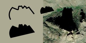
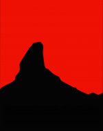
For those of you who have a copy of the Fish Treasure Map, compare the shadow cast by Miners Needle (Google Earth) to this traced line taken from the bottom of the map. I think that the similarity is enough to see that this line represents Miners Needle. Would MN have been used as an entry point, or a just a noticeable landmark?

Anyway, unless I am looking at the wrong mountain in Google Earth (not labeled) this should be MN.


Miners Needle - Fish Map.jpg
 

For those of you who have a copy of the Fish Treasure Map, compare the shadow cast by Miners Needle (Google Earth) to this traced line taken from the bottom of the map. I think that the similarity is enough to see that this line represents Miners Needle. Would MN have been used as an entry point, or a just a noticeable landmark?

Anyway, unless I am looking at the wrong mountain in Google Earth (not labeled) this should be MN.


View attachment 1747269

I believe that one is Byous Butte Hal.
And also that each landmark was drawn as "seen" from certain points along the trail.....since their appearance can greatly change, depending on where you are in the mountains.
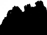
Miners Needle for example can look like a single peak when viewed from a certain area.....complete with the tilted layering as shown on the map....that being an important observation IMO.
The ash layering on WN is horizontal, as seen from any direction.

A better shot of MN as a single peak would have been taken from somewhere further to the right.
 

Attachments

  • Miners Needle ash deposits.jpg
    Miners Needle ash deposits.jpg
    823.7 KB · Views: 83
Last edited:
Hal

In the Fish/Peralta map the mines are not where are depicted in the map in regards to the known landmarks. There are some different degrees for their actual place. Remember what I have wrote about codes that use combined Xs in few Peralta maps. This is one of them.
If you look near where there are two Xs , there is written MINA which means one ( singular ) mine , so there are not two mines in that region and the Xs are not for the mines.
What is written in the map as " la caverna de oro, escondido abismo, 50 cargas mulas " was their goal in the Superstitions quest, but was never found. The place where is written on the map and some petroglyphs in the same region, lured few persons to believe the treasure is located close to the Second Water.
 

I believe that one is Byous Butte Hal.
And also that each landmark was drawn as "seen" from certain points along the trail.....since their appearance can greatly change, depending on where you are in the mountains.
Miners Needle for example can look like a single peak when viewed from a certain area.....complete with the tilted layering as shown on the map....that being an important observation IMO.
The ash layering on WN is horizontal, as seen from any direction.

A better shot of MN as a single peak would have been taken from somewhere further to the right.

To my surprise, topographical features can be labeled in GE.
It is Miners Needle.


Miners Needle 1.jpgMiners Needle2.jpg
 

Last edited:
What does the shadow look like, when it's mid-day, and the sun is to the South ?

I am working with a fixed GE image and while it allows for changing the time of viewing, it actually doesn't change the base layer image. Meaning, that same shadow shape is there, regardless of time. You are right that the location of the viewer will dictated MN's profile, that logic works both ways.

For me, that line represents Miners Needle.

Also, I can't yet prove it, but there may be more than the traditional nine mines depicted on that map.
 

Hal

In the Fish/Peralta map the mines are not where are depicted in the map in regards to the known landmarks. There are some different degrees for their actual place. Remember what I have wrote about codes that use combined Xs in few Peralta maps. This is one of them.
If you look near where there are two Xs , there is written MINA which means one ( singular ) mine , so there are not two mines in that region and the Xs are not for the mines.
What is written in the map as " la caverna de oro, escondido abismo, 50 cargas mulas " was their goal in the Superstitions quest, but was never found. The place where is written on the map and some petroglyphs in the same region, lured few persons to believe the treasure is located close to the Second Water.
markmar,
I don’t follow the code logic if you make a map to a place that you intend to return to. The X ‘s are more cross shaped and oriented vertically. I believe that they represent what is written, mines. Your “code” may have been symbols left along the trail or instructions on how to spot the Apache Mines once on site. I just don’t understand the need to encode a map that I intend to keep or pass to family.
 

Attachments

  • Weavers Needle 4.jpg
    Weavers Needle 4.jpg
    37.5 KB · Views: 65
  • Weavers Needle 3.jpg
    Weavers Needle 3.jpg
    15.2 KB · Views: 217
  • Miners Needle holeintherocks.jpg
    Miners Needle holeintherocks.jpg
    48.8 KB · Views: 69
  • Lust for Gold hoyo.jpg
    Lust for Gold hoyo.jpg
    37.5 KB · Views: 60
Last edited:
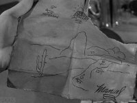
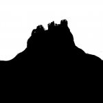
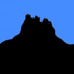
Consider the orientation of Masca El Sombrero on the map. Flip my profile picture and it matches the profile of MSE which means that it was drawn looking north. MN should be oriented the same way on the map and it is, if that line represents MN.

Anyway, for the map to be authentic, Masca El Sombrero must have already become a tradition in Mexico. I thought that the witch-brimmed, conical hat connection began in the late 1800's which would be a problem.

Masca El Sombrero.jpg
 

At the base of Masca El Sombrero may be a tenth mine. This is a tracing of what I see with the map enlarged. A cross, part of the outline of MES and in the dotted square area, something that resembles the number 15 (that is a guess). Its not clear enough to trace.


Number Ten?.jpg
 

markmar,
I don’t follow the code logic if you make a map to a place that you intend to return to. The X ‘s are more cross shaped and oriented vertically. I believe that they represent what is written, mines. Your “code” may have been symbols left along the trail or instructions on how to spot the Apache Mines once on site. I just don’t understand the need to encode a map that I intend to keep or pass to family.

The maps were not coded for the family members but if by chance they would ended in strangers hands. All the Peraltas maps which you have seen, are coded. Because if they were not, by now all the mines would been found.
This is the most logical explanation about if the maps are coded or not.
 

With the map holder goes the code if not shared and your coded map suddenly becomes useless.
What year do you think the map was made?
 

With the map holder goes the code if not shared and your coded map suddenly becomes useless.
What year do you think the map was made?

This is true,but by reading a coded map for a mine you have found, with little more thinking you will understand the concept which was used for the coding.
I believe the Fish map was made in the decade 1870-80. The same code has been used and for the Gonzalez-Clark map which was carried by Gonzales in the Superstitions in about 1876.

This version of the Peralta Fish Treasure Map dates to 1845 and a different one (The Treasurer of the Indians) to 1844. Which is the original, the Manuel Peralta Superstition Map of 1845 or the undated version? A massacre in the Superstitions would have gone unreported in 1845, less likely so in 1870 - 80.

The cross to the right of Masca El Sombrero and above Miners Needle, could that be Wagoners find?

https://www.desertusa.com/lost-dutchman/peralta-stones2/peralta-gold2.html
 

Top Member Reactions

Users who are viewing this thread

Latest Discussions

Back
Top