Continuum

Perhaps I should have written that with more thought. I provided the key so you would know what those symbols were, but what they represent, as in Mine and Location name was the point of my question.

I haven’t been able to identify either and thought that you might.


Hermano,

Sorry that I can't help you with this. In the ten years that I have been on these forums, I have not really looked into anything that is not tied to Jacob Waltz, or the PSM's. I have never bothered to find where the Vulture mine, and many others are, or the Bat cave, and many other popular caves. I have not even bothered to search for the location of the cave with a house in it, the skeleton cave, or cave with sandals. The only cave I know of it the hideout cave, and it is not above the mine, nor is there a tunnel below the mine. As Oroblanco says, there are too many different treasure stories that have come out of those mountains, and most Dutch hunters can't help but link them together.

The same goes for the PSM's, which are the real deal. After they were uncovered, fakes somehow started to pour out of the Superstitions. Since I know the stone crosses are fake, I have never bothered to even look for Bilbery's claim. I am not a historian and have only learned about certain places, and individuals linked to the Superstitions, thanks to you guys. I enjoy having something to read when I come here, even if it has nothing to do with the LDM.

Homar
 

I am going to ask the curator at the PRINCETON Library for an opinion.
And look at your examples in ImageJ.

Here is one that supports my argument that the Tortilla Flat area was at least accessed, long before it became a stop on the Apache trail. 1876


View attachment 1745633

What is on that particular map which tells you that ?
 

Attachments

  • 1876- Rand McNally Map.jpg
    1876- Rand McNally Map.jpg
    132.5 KB · Views: 65
Acequina - looks like the Tortilla Flat area (this is incorrect). 1865, thirteen years earlier that the Hinton Map.

Acequia is the closest that I could come to translating Acequina.

" Rivera explained that "acequia" refers not only to the physical trench in the ground, but also, and just as importantly, to the system of community self-governance. "You don't just have a ditch; you belong to an acequia," he explains, emphasizing the the word also means the co-op of farmers who share the water and govern their own use of it."

View attachment 1745765

Yes.....incorrect .
Perhaps I should have outlined "Las Acequias" on the canals map I posted.


Tortilla Flats does not have enough surface area for any sizeable farming community IMO.
Mormon Flat probably did, prior to the creation of Canyon Lake, and in fact cattle were grazed there at one time.
It was also where old arrastres were found along Tortilla Creek, not far from the Salt R. While TF probably was used as a campsite by many travelers throughout the ages, having water, shade trees etc., and in fact was chosen as a good place for a work camp during construction of the Mesa-Roosevelt road, there has never been any mention of ruins anywhere in the area.....or ancient canals. Both flats were likely also too prone to flooding for any kind of permanent farming settlement. The military did map a trail through there however, which showed a "skirmish" location there or nearby.
 

Attachments

  • hohokam-canals crop.jpg
    hohokam-canals crop.jpg
    923.2 KB · Views: 59
  • military map 1868.jpg
    military map 1868.jpg
    33.1 KB · Views: 79
Last edited:
Miller's two shafts and a tunnels don't match.
The Bilbrey mines I think are on the Southwest corner of Tortilla Mountain(?).
But the map dates to 1878.

I think that the two unidentified creeks are Cottonwood and Tortilla (because of its SE angle).
Note: if it is the Bilbrey mines on Tortilla Mountain, that creek below the symbols would have to be Peter's Canyon.

View attachment 1745763

Why would they have to match ?
Maps of that era were far less accurate than what we have today.....obviously. So, I'm not sure why you would expect a "match" in exact location, number, or even type of mine .It's all guesswork IMO.
The Miller mines were believed to be older Spanish or Mexican mines that Miller had learned of from an Apache (Apache Jack ?), and Sims Ely had written about a mine in that general area as well, with Jim Bark having been told about it by a Pima indian earlier than 1920.
The Miller Mines are shown on this topo.....
 

Attachments

  • Miller mines topo.jpg
    Miller mines topo.jpg
    263.8 KB · Views: 72
Last edited:
Yes.....incorrect .
Perhaps I should have outlined "Las Acequias" on the canals map I posted.


Tortilla Flats does not have enough surface area for any sizeable farming community IMO.
Mormon Flat probably did, prior to the creation of Canyon Lake, and in fact cattle were grazed there at one time.
It was also where old arrastres were found along Tortilla Creek, not far from the Salt R. While TF probably was used as a campsite by many travelers throughout the ages, having water, shade trees etc., and in fact was chosen as a good place for a work camp during construction of the Mesa-Roosevelt road, there has never been any mention of ruins anywhere in the area.....or ancient canals. Both flats were likely also too prone to flooding for any kind of permanent farming settlement. The military did map a trail through there however, which showed a "skirmish" location there or nearby.

SH, would agree that Mormon Flat is probably what Hal's looking at on his map. The junction of Tortilla Creek and the Salt. Tortilla and LaBarge used to merge just before dumping into the Salt within spittin' distance of Mormon Flat....literally spittin' distance...from what I can see, at the large scale the 1878 map Hal posted was printed at, Mormon Flat and Tortilla Flat would be pretty much indistinguishable as separate places. Whether or not there were any ruins there is unknowable, due to floods prior to any Americans showing up, and as we know, Canyon Lake is in the way now ;).

The military trail on the 1868 military map is as you probably know the one that went though the mountains using Tortilla Creek. IMO, the 1864 "skirmish" is the Battle of Bloody Tanks. The description of participants matches the topography exactly. But that is another topic belonging in another thread ;)

Hal, I think you are onto something here, looking forward to the rest.
 

Hermano,

Sorry that I can't help you with this. In the ten years that I have been on these forums, I have not really looked into anything that is not tied to Jacob Waltz, or the PSM's. I have never bothered to find where the Vulture mine, and many others are, or the Bat cave, and many other popular caves. I have not even bothered to search for the location of the cave with a house in it, the skeleton cave, or cave with sandals. The only cave I know of it the hideout cave, and it is not above the mine, nor is there a tunnel below the mine. As Oroblanco says, there are too many different treasure stories that have come out of those mountains, and most Dutch hunters can't help but link them together.

The same goes for the PSM's, which are the real deal. After they were uncovered, fakes somehow started to pour out of the Superstitions. Since I know the stone crosses are fake, I have never bothered to even look for Bilbery's claim. I am not a historian and have only learned about certain places, and individuals linked to the Superstitions, thanks to you guys. I enjoy having something to read when I come here, even if it has nothing to do with the LDM.

Homar

Many are linked, and if Waltz found something in the Superstitions, there is a good chance that it is only one of several. The Peralta story keeps me interested. I believe it, most of it.
 

SH, would agree that Mormon Flat is probably what Hal's looking at on his map. The junction of Tortilla Creek and the Salt. Tortilla and LaBarge used to merge just before dumping into the Salt within spittin' distance of Mormon Flat....literally spittin' distance...from what I can see, at the large scale the 1878 map Hal posted was printed at, Mormon Flat and Tortilla Flat would be pretty much indistinguishable as separate places. Whether or not there were any ruins there is unknowable, due to floods prior to any Americans showing up, and as we know, Canyon Lake is in the way now ;).

The military trail on the 1868 military map is as you probably know the one that went though the mountains using Tortilla Creek. IMO, the 1864 "skirmish" is the Battle of Bloody Tanks. The description of participants matches the topography exactly. But that is another topic belonging in another thread ;)

Hal, I think you are onto something here, looking forward to the rest.

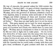
I read that the battle may have been closer to Globe. But a different account puts it 60 - 70 miles NE from the Pima Villages, today the Gila River Indian Community(?). Globe is 80 -90 miles from there. The Tortilla Flats area is 60ish miles.

The battle of 24 January 1864 and the January 1864 “skirmish” at Tortilla Flat may have been the same. Woolsey was on the upper Verde by 28 February. At the mouth of the Verde on 24 January.

”[FONT=&quot]Woolsey dispatched couriers to the chiefs of the Maricopas and Pimas, and each of them joined him at the mouth of the Verde, with thirty warriors from each tribe. They took the trail of the Apaches and followed it into Tonto Basin, where the chief of the Pimas, fearing an ambush, decided to go no further, and withdrew his followers, but the chief of the Maricopas, Juan Chiavria, who was a great friend of Woolsey’s, stayed with the whites, with his warriors. They followed this canyon for about three miles when they found themselves surrounded by about four hundred of the Apaches.”[/FONT]

81379A9E-8FDB-472B-878A-826B6B523842.jpeg
 

Last edited:
I read that the battle may have been closer to Globe. But a different account puts it 60 - 70 miles NE from the Pima Villages, today the Gila River Indian Community(?). Globe is 80 -90 miles from there. The Tortilla Flats area is 60ish miles.

The battle of 24 January 1864 and the January 1864 “skirmish” at Tortilla Flat may have been the same. Woolsey was on the upper Verde by 28 February. At the mouth of the Verde on 24 January.

”Woolsey dispatched couriers to the chiefs of the Maricopas and Pimas, and each of them joined him at the mouth of the Verde, with thirty warriors from each tribe. They took the trail of the Apaches and followed it into Tonto Basin, where the chief of the Pimas, fearing an ambush, decided to go no further, and withdrew his followers, but the chief of the Maricopas, Juan Chiavria, who was a great friend of Woolsey’s, stayed with the whites, with his warriors. They followed this canyon for about three miles when they found themselves surrounded by about four hundred of the Apaches.”

View attachment 1746068

Hal, there was Battle of Bloody Tanks Wash near Globe but it was later than Woolsey's that took place along the Salt in JAN 1864. The similar names have caused confusion among authors going back almost 100 years.

The military map SH posted has been added to. Many of the labels are not original to the map, including the "Skirmish JAN 1864", which were notes made by the map's modern-day owner. I believe, however, that this person was entirely correct, the skirmish he noted was the site of Woolsey's JAN 1864 fight on his 1st expedition of 1864.

We had a recent discussion thread on the Battle of Bloody Tanks where most of this was discussed and a lot of source material was posted. I can forward some more references if you're interested.

This is of course unrelated to what you're looking for though. Whether or not there was a large irrigated rancheria or village at Mormon Flat I don't know, but it would have been an awful waste if they hadn't used it. There was a fairly large rancheria at Quail Springs on Lewis and Pranty Creek, oddly enough not far from their cabin which we discussed in an earlier thread. There was another large community about where Tortilla Ranch was later. Just pointing out some possibilities.

The mines indicated by dots and an "X" on the map you posted earlier IMO were indeed where you suspect they are. IMO you are in the right area. Interested in what you may dig up. Take care, Jim
 

"The military map SH posted has been added to. Many of the labels are not original to the map, including the "Skirmish JAN 1864", which were notes made by the map's modern-day owner. I believe, however, that this person was entirely correct, the skirmish he noted was the site of Woolsey's JAN 1864 fight on his 1st expedition of 1864."

Military maps usually do have changes made during the time they are in use.
This one may have once decorated the wall of the commanders office at Fort Whipple. As patrols came back to give their reports, routes and battle locations were added to the map, and not always by the same person.
 

Last edited:
For reference and comparison:

1900-1907-modern topos
 

Attachments

  • 1900 topo A.jpg
    1900 topo A.jpg
    358.9 KB · Views: 64
  • 1907 topo A.jpg
    1907 topo A.jpg
    168.9 KB · Views: 65
  • canyon lake topo A.jpg
    canyon lake topo A.jpg
    224.4 KB · Views: 68
Last edited:
Out of all the "maps", the Fish-Peralta map is the closest match to what we are currently talking about re: Mormon Flat.
This is my partial interpretation ....
 

Attachments

  • Fish Map 1 labled.jpg
    Fish Map 1 labled.jpg
    208.9 KB · Views: 197
Wayne is there not something on the fish map that tells you to reverse things?

No.
Why would anyone have to reverse a map to read it ? Unless they were dyslexic.
Maybe if the intent was to invent a new game, but these guys weren't into playing games.
As far as security goes, is not the fact that these maps were usually held privately and not shared with outsiders not enough ?
I think such paranoia is more prevalent among treasure hunters, than it ever was with those who made most of these maps. In many cases these maps were created for someone and "gifted" to them as some form of payment or favour.
 

Last edited:
No.
Why would anyone have to reverse a map to read it ? Unless they were dyslexic.
Maybe if the intent was to invent a new game, but these guys weren't into playing games.
As far as security goes, is not the fact that these maps were usually held privately and not shared with outsiders not enough ?
I think such paranoia is more prevalent among treasure hunters, than it ever was with those who made most of these maps. In many cases these maps were created for someone and "gifted" to them as some form of payment or favour.

Thanks, Wayne
 

Last edited:
The mines indicated by dots and an "X" on the map you posted earlier IMO were indeed where you suspect they are. IMO you are in the right area. Interested in what you may dig up. Take care, Jim

Hope Hal's not planning to dig up any of the campgrounds out there Jim.
If so, I'd imagine it going something like this.....

Ranger....."Excuse me sir, what are you doing there?"
Hal....down in freshly dug hole....."digging this hole here"
Ranger....looking down into hole...."What do you think is down there?"
Hal...."My car keys."
Ranger...."Your car keys ?"
Hal....angrily jams shovel into dirt...."yah, my pet packrat took them and hid them down here somewhere !!!!"

Asking for forgiveness instead of asking for permission - always a sound strategy in life.
 

SH, those guys that made all those fake maps were all about games ;) It's all good as long as everyone has fun. Sometimes it don't work out that way. People are still paying money for maps and manuscripts of stone chiselers. None of my business, but I know a game when I see one being played.

IMO folks would be better off with a real map like the one Hal posted, looking for a few hopeful placers and "wing and a prayer" prospect holes. As long as they stick to the car-keys and pack-rat story, anyway.
 

"The military map SH posted has been added to. Many of the labels are not original to the map, including the "Skirmish JAN 1864", which were notes made by the map's modern-day owner. I believe, however, that this person was entirely correct, the skirmish he noted was the site of Woolsey's JAN 1864 fight on his 1st expedition of 1864."

Military maps usually do have changes made during the time they are in use.
This one may have once decorated the wall of the commanders office at Fort Whipple. As patrols came back to give their reports, routes and battle locations were added to the map, and not always by the same person.

Have you seen the original map?
 

Out of all the "maps", the Fish-Peralta map is the closest match to what we are currently talking about re: Mormon Flat.
This is my partial interpretation ....

Its logical based on your interpretation of what you think you are seeing, but you have misidentified several landmarks on the map.
This I can write with certainty.
 

SH, those guys that made all those fake maps were all about games ;) It's all good as long as everyone has fun. Sometimes it don't work out that way. People are still paying money for maps and manuscripts of stone chiselers. None of my business, but I know a game when I see one being played.

IMO folks would be better off with a real map like the one Hal posted, looking for a few hopeful placers and "wing and a prayer" prospect holes. As long as they stick to the car-keys and pack-rat story, anyway.


Yes, you do, know.
 

Top Member Reactions

Users who are viewing this thread

Back
Top