Al D
Bronze Member
- Joined
- Jul 23, 2011
- Messages
- 2,066
- Reaction score
- 3,538
- Golden Thread
- 0
- Location
- Gold canyon AZ
- Detector(s) used
- DJI Air 2S
- Primary Interest:
- Cache Hunting
Any luck with this Dave?i'll try to get hold of him if i can
Any luck with this Dave?i'll try to get hold of him if i can
no..we haven't heard anything yetAny luck with this Dave?
fOR ARGUMENT SAKE LETS SAY YOU ARE CORRECT, HOW EXACTLY IS THAT CLUE STATED (OR WAS IT STATED) IN ITS MOST EXCEPTED VERSION?
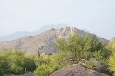
Four Peaks and their little brothers .
Shot from 88, near First Water Road.
Four Peaks and their little brothers .
Shot from 88, near First Water Road.

no..we haven't heard anything yet
 Thanks Dave for trying to contact him, I guess he will get around to checking in when he gets the time.

thanks for the update royHe was at a restaurant with his wife and friends in Lake Havasu City a couple of days ago, was posted on FB, so must be OK and too busy to get on here.

Bump
nobodie
The Waltz map which shows the mine and the caches is very hard to recognize in the fields . Was also hard for me until i have recognized the mine site from other maps and clues . If you know where is the LDM , then I will tell you where is the caches because I like your style .
The cache sites are two and are in these directions from the mine :
The first is 130 yards and 24*SE , and the second is 160 yards and 45*NE .
View attachment 1223325
I don't know who nobodie is.
There`s a cave with a rock house in Rough Canyon, it`s a rough place, there are cats around there.https://hikearizona.com/decoder.php?ZTN=1900
Wish I could see that photo and try to recognize the area.Anybody else here, heard anything about a large cache of gold ore being found recently in the area of the pit mine?
Apparently very close to where Chuck found the cargo panniers last year. All bagged and ready to go.
Regards:SH.