A Heap of Proof.

Status
Not open for further replies.
Hal Croves, Amigo, Thank you, I have already given more Info on the dark circle and the trail than most people ever knew about,
I hope this helps some people in trying to figure things out, this Info and more is just one reason I spent years using palomino mnt
as my camping site. plus there is a pure diatomaceous earth deposit located there, plus at some time in history someone had drove
an old vehicle back there, I found that amazing,:dontknow:this is just some of things I wish to share.NP :cat:

Unfortunately, what I know about the site is only from reading. Something about Aylor moving to a nearby camp after reading a decent copy of Bark's notes. Also, that there is an old Arrastra on the North end. I am interested in the Mt. name and what Aylor was doing there.
 

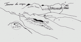
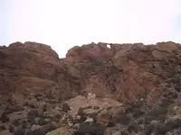
My personal opinion is that these three profiles each represent the same ridge line, as seen from a location north of the Weavers.

View attachment 1189628

One profile line from each map and a third taken from a photograph of the actual location.
The two profiles from the maps are essentially hand sketches of what the artist was remembering or perhaps seeing.


Last edited:
Hal Croves, Amigo, Thank you, I have already given more Info on the dark circle and the trail than most people ever knew about,
I hope this helps some people in trying to figure things out, this Info and more is just one reason I spent years using palomino mnt
as my camping site. plus there is a pure diatomaceous earth deposit located there, plus at some time in history someone had drove
an old vehicle back there, I found that amazing,:dontknow:this is just some of things I wish to share.NP :cat:

Yes NP, the information that you have shared and what I am finding seem to be connected. If this is correct, I think that "Ojo de aguila" is depicted on the stone maps and perhaps, when standing in it's opening, or on top of it's arch, the next step is seen, perhaps there using the next stone. JMO. What is amazing is that if you accept the maps being read this way, a few other maps make complete sense. An example:


Hal Croves, Amigo:occasion14:
Yes it does, I cannot understand why this area has been ignored for so long, when I was younger so many people had passed this way,seems that they had a better understanding of clues but could not figure things out, they would show up full of energy,stay for awhile,and leave,but they would leave not disappointed ,but eager to return. it would be like they knew something was here and theyjust could not see it. I think they were right and I think your right.np:cat:
 

Last edited:
Hal Croves, Amigo:occasion14:
Yes it does, I cannot understand why this area has been ignored for so long, when I was younger so many people had passed this way,seems that they had a better understanding of clues but could not figure things out, they would show up full of energy,stay for awhile,and leave,but they would leave not disappointed ,but eager to return. it would be like they knew something was here and theyjust could not see it. I think they were right and I think your right.np:cat:


Hopefully, you will keep writing about that location. Here are the three profiles again as they could have been drawn. Personally, I think that this view would have been far to obvious for those who are familiar with the Superstitions which, may be why is wasn't used. The Needle was represented as a treasure symbol.


Last edited:
Ojo de Aquila in a map ( into circle ) .

Ojo.gif
 

Back in the proper era, there were two well traveled trails to Black Top. One, of course, is the Dutchman's/Bull Pass Trail which cuts across the north end of Black Top Mesa and the other is the Cutoff/Switchback Trail on the south end of the mesa that connects East Boulder and Needle Canyons.

There are other less well known and explored trails on and around Black Top but they are not easy to find and are probably not traveled today, except by some of the old timers still around.

Good luck,

Joe Ribaudo

The Cutoff/Switchback from your map or, your solution to the stone maps, superimposed onto a GoogleEarth image of the same area. Close to scale.


If this is the correct way to read the map, it, the map, will need a more accurate description or name. It could be a Peralta map (I am not convinced) but if this is right, I think that the name should be something more specific to what the map actually represents like, The Palomino Mountain Map. The Palomino Mountain Map may only lead to a view (a starting point). And if the Horse & Priest stones turn out not to have been carved by Travis, as so many are being lead to believe, then perhaps the key to understanding them is the view from Ojo de Aguila.


First,

It is not "Ojo de Aquila". It is "Ojo de Aguila" (Eagle's Eye). It is actually a pretty well known spot in the Supers. It is better known as "Aylor's Arch" (atop Palomino Mountain), named after Chuck Aylor. The entire scene in "Lust for Gold" where Barry Storm finds the "eye" near the end, and knows that he has to be in the right place at the right time for the moon to shine through the arch and light up the entrance to Waltz' Mine. THAT basically represents Aylor's Arch and Black Top Mesa.

aylor05.jpg

Mike
 

First,

It is not "Ojo de Aquila". It is "Ojo de Aguila" (Eagle's Eye). It is actually a pretty well known spot in the Supers. It is better known as "Aylor's Arch" (atop Palomino Mountain), named after Chuck Aylor. The entire scene in "Lust for Gold" where Barry Storm finds the "eye" near the end, and knows that he has to be in the right place at the right time for the moon to shine through the arch and light up the entrance to Waltz' Mine. THAT basically represents Aylor's Arch and Black Top Mesa.

View attachment 1190219

Mike

I thought that I had spelled it correctly unless when quoting someone. Aguila.
Yes, that landmark is today named Aylor's Arch after Chuck Aylor who relocated his camp to the area in the late 30's(?). Thru the arch one can apparently see things on Black Top Mesa that are very "important".

One thing to keep in mind is that the map read this way begins at a campsite in Gold Canyon and IMO, ANYTHING having to do with Gold Canyon is suspicious for the obvious "theatrical" reasons. They could very well be discarded movie props.

Could be but, who knows at this point.
Still, the solution is a decent enough one.

Aguila.... A famous Mexican leader was know by that same name.
 

Last edited:
:coffee2:Aylor was just one of many to hunt for treasure and mines in this area ,One thing about areas like this is they cannot be" FAKED",they are a permanent symbol and marker,also,
at the top of palomino mnt is a perfect place to watch the burro migration twice a year,I have mentioned this before. NP:cat:
 

Last edited:
Hal Croves, Amigo:coffee2:
One thing I think has been taken out of context is a clue taken from Bark's notes and every other persons notes concerning the mine, they all mention the clue that you have to go
through a cave or hole to get to the mine, I do not believe they had the right meaning to this clue,or just did not know, What if you had to look through a hole to find the mine, or trail. just something for you to think about.NP:cat:
 

I thought that I had spelled it correctly unless when quoting someone. Aguila.
Yes, that landmark is today named Aylor's Arch after Chuck Aylor who relocated his camp to the area in the late 30's(?). Thru the arch one can apparently see things on Black Top Mesa that are very "important".

One thing to keep in mind is that the map read this way begins at a campsite in Gold Canyon and IMO, ANYTHING having to do with Gold Canyon is suspicious for the obvious "theatrical" reasons. They could very well be discarded movie props.

Could be but, who knows at this point.
Still, the solution is a decent enough one.

Aguila.... A famous Mexican leader was know by that same name.

Hal & Mike

As I recall, the old timers called Aylor's Arch the Eye of the Horse, or Caballo Oja. If you make it the eye on the horse of the Stone Maps, the head, neck and back of the horse can be roughly laid out on a topo.

Good luck,

Joe
 

I thought we are to go down past a needle. Instead of the point being up, there is a formation that looks like were the thead goes. A hole in the needle.
 

Status
Not open for further replies.

Top Member Reactions

Users who are viewing this thread

Back
Top