Unusual rock carving uncovered from heavy rains

Mark60, if it was me I would work each carving separate, I would work the Triangle first, get something with a sharp point ( lead pencil ) that will make a point in the center of the marble size hole, make a mark at each corner with your pencil and draw a line between the corner marks to make a triangle, the dot should be a reference point to find the direction to the corners that should be aprox 300 feet from your reference point which should be marked possibly with a drill hole. Actual distance that I would expect is 189.5 feet ( Cordell ) What you have is possibly a map , First thing is to get a starting point which is your rock with the drawings, you will need a compass, fiberglass 100 foot measurng tape and lots of endurance.

dsty, interesting you should mention a drill hole, on page 4 of this thread I show a pic of an owl that mdog pointed out to me, anyway this owl has a drill hole that is approx 2" round and 8" deep with a rod stuck in it which you've commented on before in another thread, it points back to the carved triangle rock ? the bearing from the drill hole to the triangle would be 320*NW I should also note the distance as shown on a GPS app on my phone is 195', now is the accuracy of the GPS on my phone that good ?, well thats up for debate, I have not been able to actually use a tape to measure the distance because the water crossing presents an issue but for me the distance is close enough + or - to call it a cordell..if the owl and the carved rock are both anchors of the triangle i just need to locate the third, or is the owl the center of the triangle?? too many questions, gonna need more coffee
 

Last edited:
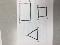
Mark 60 will you post a triangle, a square, and a rectangle use number s at each corner for reference, Degrees that we will use 45---135 ....225.....315, distances will be in feet one side will be 276 and the others will be 315 feet Thanks
 

Last edited:
Mark 60 will you post a triangle, a square, and a rectangle use number s at each corner for reference, Degrees that we will use 45---135 ....225.....315, distances will be in feet one side will be 276 and the others will be 315 feet Thanks

dtsy, ok i can do that I might be a lil confused on what your asking, what am I using as an anchor point the carved rock or the owl, also what orientation or does it matter, guess its late and not enough coffee
 

This is how the cache sites were placed in the Settlers league and were set up, as we go along it will give you and others that are working their sites just another bit of info, That's the reason that I ask if you could / would do it, I don't know if its all there are but its all I have seen. We can go thru the entire method. The Start of a League Square looks to me like its at the South East corner, the reason is because of all maps go from small degree to the West and from the small degree to the north. Its gonna be a slow process, one of the things is that the 25 league Square is the letters of the alphabet = 26 and they used 25. I think that its getting cart in front of the horse if we do any other way. thanks
 

This is how the cache sites were placed in the Settlers league and were set up, as we go along it will give you and others that are working their sites just another bit of info, That's the reason that I ask if you could / would do it, I don't know if its all there are but its all I have seen. We can go thru the entire method. The Start of a League Square looks to me like its at the South East corner, the reason is because of all maps go from small degree to the West and from the small degree to the north. Its gonna be a slow process, one of the things is that the 25 league Square is the letters of the alphabet = 26 and they used 25. I think that its getting cart in front of the horse if we do any other way. thanks

dsty ok here you go hope this will work, once again all your advice is very much appreciated thank you ...

symbols.JPG
 

Could this be another clue to Oak Island, Sorry i had to.
 

Sometimes they only show you two corners, try using 33 inch paces between them ( pace ) just to check if they are, if they are really corner markers you should be able to be use the Jesuit measurement, one of degrees should be 320

dsty, just wanted to follow up on this, the bearing from the drill hole/owl to the carved triangle is 320 degrees and the distance is a cordell + or - a few feet according to my GPS app
 

Last edited:
Once more, This is how I have found the method seems to work and I usually try to locate the south east corner, it should show the pattern of how the site is laid out, there should be another showing the lay out inside the site, small square ( 6 / 8 inch ) rock, small drill holes, I have some posted as a reference in the start of Old Hand dug holes or I will bring it to the top would be faster, I think its shows 4 in a rectangle. Kinda pressed for time today
 

Civil war marker is a possibility(maybe marking a good spot to cross the water? I would also consider that it might have a link to Freemasonry.
 

Coach Stack thanks for the ideas, actually this spot is the worst place to cross, for a creek 20yrds either direction is flat but this area is pooled
 

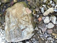
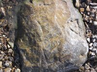
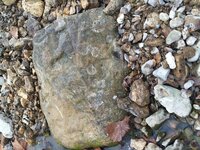
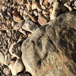
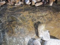
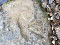
attached are some different angles of the carved rock, I see a snake, an upside down 7 the triangle of course along with the pointer off to the side of it anyone see anything elseIMG_1915.JPG100_0728.JPGIMG_1926.JPGimage.jpeg.jpgIMG_1927 [50498].JPG
 

Last edited:
100_0731.JPG100_0770.JPG100_0760.JPGIMG_1938.JPG100_0770.JPG100_0788.JPG the owl is in the bottom center with bluff aboveIMG_1929.JPG


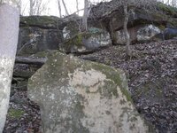
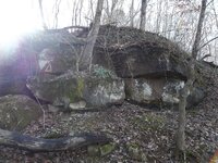
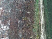
the owl/drill hole and some background pics
 

Last edited:
It may take awhile But it seems that the South East corner of your site should indicate how things are laid out, square, triangle, rectangle, the compass degrees are important and the distances between the symbols are important, if you have all the info it will be pretty easy, IF you have all the corners then you have the pattern of how its laid out and its as easy as it can get. The total distance of the three sides added together are the total distance to the cache site the direction to travel will be shown in the west symbol # 3, the # 1 corner will be how its placed in the ground distance , direction, everything is important and only the corner markers will be of use, For instance if the 3 distance of the sides are 90 X 3 =270 feet I would have used = 33 inches pace but don't have my calculator with me, the distances will be different at each location if you have 3 sides as a triangle or a square or a rectangle it is important to have all of the info. I need to correct the post where I was trying to work thru my stroke THANKS for understanding kinda got off track some They will put information on the bottom of boulders the marked ones will be identifiable if you look for traps , and features such a piece of pie shape that's knee high and 40 inches long and on a slope anything that will trap you stay on the up hill side of it. Got to get more later.tomorrow
 

Last edited:
THANKS dsty for all your help
 

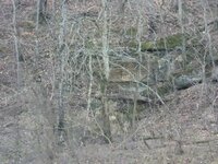
mark60, your photo # 73, showing the rock cliff is really interesting. Re: the two triangles seen on the left side, one solid and the other outlined. I see
the rock just below as either a turtle, the head of which is directly under the triangles, OR, if you look at the same rock, from the right side it appears to be a whale; there is a mouth, an eye, and at the bottom directly under the eye, a flipper. The tail is under the triangles.
I agree with dsty's comments in #74, and would really look this place over and figure out what the triangle codes are.
You may be onto something huge. Good luck.
 

Mark60 All of the triangles, squares, rectangles, have the same system, SE corner # 5 = how the site is laid out, # 4 one site that I found that had 4 corners had a 5 by 4 inch rectangle with a T carved at the nw corner I believe it indicates that information lies at the # 7 NE corner Depth indicator Square flat rock was upside down = 7 ft 7 inches Was measured in CM. # 6 had direction to burial location. #s 8 /9 / 10 /11 are the same on corner markers,/ Rectangle = more distance between maps one map shows how everything is laid out one has information on the corner that has the old hand dug hole. Thanks to all of you wonderful folks that encouraged me to keep going thru the Ist drill hole, seems to me that it has been SO MUCH FUN, still lots to learn wish I had the legs to take me another 76 years. Good Luck Folks
 

Last edited:
mark60, i just opened this site and saw your stone with an equal latteral triangle and dot in the middle.
The triangle can have a dot, circle, or eye in the middle and they all mean the same thing;
a triangle formed by trees or rocks a cache should be buried in the middle.

I noticed a small cut mark near one corner, this may be the directional to the triangle. Also toward the bottom is what looks like an eye.
If this was chiseled, it could also be a directional indicator. Good luck.

grillz thanks for looking at the pics not sure where the eye is your referencing I'll have to go back and look at the pics again, I believe this rock is holding a lot of clues and trying to decipher it is my white whale...
 

Mark60 All of the triangles, squares, rectangles, have the same system, SE corner # 5 = how the site is laid out, # 4 one site that I found that had 4 corners had a 5 by 4 inch rectangle with a T carved at the nw corner I believe it indicates that information lies at the # 7 NE corner Depth indicator Square flat rock was upside down = 7 ft 7 inches Was measured in CM. # 6 had direction to burial location. #s 8 /9 / 10 /11 are the same on corner markers,/ Rectangle = more distance between maps one map shows how everything is laid out one has information on the corner that has the old hand dug hole. Thanks to all of you wonderful folks that encouraged me to keep going thru the Ist drill hole, seems to me that it has been SO MUCH FUN, still lots to learn wish I had the legs to take me another 76 years. Good Luck Folks

dsty, thanks for the knowledge and insight you have provided as soon as the rains subside I hope to work it out and see where it takes me
 

Top Member Reactions

Users who are viewing this thread

Back
Top