Unusual rock carving uncovered from heavy rains

Sometimes they only show you two corners, try using 33 inch paces between them ( pace ) just to check if they are, if they are really corner markers you should be able to be use the Jesuit measurement, one of degrees should be 320
 

dsty' I can tell you 320 is very possibly one of the degrees, the compass headings I have for all 3 points are divisible by a prime #, i will have to go back an check the distance between the 2 markers and verify the bearing on the markers if it's not 320 it's really freakin close:censored:
 

Any news
I waited to bring the pictures but you have not provided
 

Can you bring a picture of a girl to the front triangle to see what the corresponding teacher
 

JubaII not sure what your asking the translator is not working properly
 

JubaII the triangle is 4"x 4"x 4" the bearings would be 15N ,210SW, 120SE, 15N would be the top
 

1.jpg


From 10 meters to 30 meters Is there a rock group


Last edited:
I'm trying to determine where to go with all of this, I've been doing some research on spanish symbols, reading some KGC forums checking into the history of the area more, and this is kind of what I know just trying to figure which way to go.. Spanish Symbols,
in regards to the carved rock, ok it has a triangle with a dot in the center, some say to find the triangle and determine the center? is the rock one point of the triangle ? some definitions say its under the rock or in the trees in regards to any treasure/cache, on top of the rock there appears to be a snake, some research says it's pointing to treasure/cache, would would be to the East??, I cannot verify till the water goes down which it hasn't yet, but am pretty sure a line across the bottom of the triangle will give me a bearing to a cemetery and a masonic plot less than an 1/8th mile away.

In regards to the masonic plot there is a daughter I can find no official records for her by the name on the headstone "possible alias" or she never existed on what is a very nice obelisk/headstone there is a reference of another girl same DOB & DOD,but no grave markers found and there are other children that do show up in the census records but not her? one of the meanings for her name is Latin for "The Farthest Point" ? could this be a corner of the triangle?, also there is an inscription/poem from the 1800's on the side of the obelisk at the base that reads.

The light of her young life went

As sinks behind the hill [down

The glory of a setting star

Calm suddenly and still.

the original verse reads as follows

The light of her young life went down

As sinks behind the hill

Clear, suddenly and still

so the last word "Down" was dropped to the 2nd line and a bracket "[" was placed in front which by the way is a spanish symbol for tunnel and the 1st word last line was changed from clear to calm? so the stonecutter was drunk, lazy or did it on purpose?
 

IMG_2002.JPGThe Family Plot, if I step it off is 19step by 14step which you can add and come up with 33 & 66 ? this is all I have on this for now
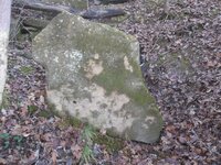
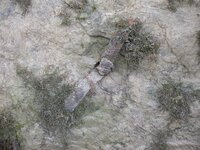
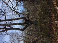
The Trees, right now I can identify 3 trees 1 is the goal post which is inline with a bearing from the carved rock, 2 is the Knob tree also inline with a bearing from the rock, which then has a knob pointing to broken ledge/slab with the drill hole and odd metal tabs which is 33steps from the knob?. 3, is the tri-forked tree up at the cemetery this also confuses me still working on it.I get that these misshapen trees were used as indian trail markers but I dont think these particular ones are old enough, most of the native americans were moved out by 1840 in this area so these trees don't fit the history, but they were clearly manipulated for a reason.

100_0758.JPG100_0759.JPG

The Carved Rock where all this began, I think there is a lot more this rock is telling me with some symbols I just haven't been able to decipher yet or clearly see for that matter but like I stated the water and the weather are against me right now,I've looked at this rock from so many different angles using so many different photo editors i just need to step back from it for a bit, with the exception of the carved rock I can find no other carvings on rocks or trees anywhere unless you include the drill hole and the stonemason's oddities on the monuments? so this is where I'm at for now..
 

View attachment 1264882The Family Plot, if I step it off is 19step by 14step which you can add and come up with 33 & 66 ? this is all I have on this for now

The Trees, right now I can identify 3 trees 1 is the goal post which is inline with a bearing from the carved rock, 2 is the Knob tree also inline with a bearing from the rock, which then has a knob pointing to broken ledge/slab with the drill hole and odd metal tabs which is 33steps from the knob?. 3, is the tri-forked tree up at the cemetery this also confuses me still working on it.I get that these misshapen trees were used as indian trail markers but I dont think these particular ones are old enough, most of the native americans were moved out by 1840 in this area so these trees don't fit the history, but they were clearly manipulated for a reason.

View attachment 1264883View attachment 1264884

The Carved Rock where all this began, I think there is a lot more this rock is telling me with some symbols I just haven't been able to decipher yet or clearly see for that matter but like I stated the water and the weather are against me right now,I've looked at this rock from so many different angles using so many different photo editors i just need to step back from it for a bit, with the exception of the carved rock I can find no other carvings on rocks or trees anywhere unless you include the drill hole and the stonemason's oddities on the monuments? so this is where I'm at for now..

The rock on the left looks like something I've run across. I thought the shape was like an owl and the tail was used to point a direction
to go. This worked for me three times and was used to define a large triangle with a 1200 yard perimeter. Two times, the tail was pointed
left, like yours, and the third time the tail was straight down. The longest distance travelled was 500 yards to the west. Next longest was
450 yards NE and the shortest was 275 yards SE. Was there something that led you to this rock?
 

mdog, i came to this rock from a tree that was on a line from the carved rock ,this tree had a rather large knob that was pointing directly to this slab and it was 33 paces, now that you mentioned the owl I do see it now, this slab and the knobby tree would be about 75yards from the carved rock, i can be more precise if needed but i dont have my numbers in front me right now
 

mdog, i came to this rock from a tree that was on a line from the carved rock ,this tree had a rather large knob that was pointing directly to this slab and it was 33 paces, now that you mentioned the owl I do see it now, this slab and the knobby tree would be about 75yards from the carved rock, i can be more precise if needed but i dont have my numbers in front me right now

Check the direction the tail is pointing and see if there is anything over that way. Also what direction is the tail pointing.
If it's taking you to a third point, map it out and find out what kind of triangle you have. What direction is the slab from
the carved rock?
 

thanks mdog I'll take a look and see where it goes, the slab lies SE from the rock, the tail would be pointing WSW
 

thanks mdog I'll take a look and see where it goes, the slab lies SE from the rock, the tail would be pointing WSW

You might want to try looking out to a couple hundred yards in an arc that goes from W to SW. Is there a bluff
to the west or some higher ground? IF there is another marker, it might be a smaller rock, maybe a foot and a half,
but heavy and buried deep enough into the ground to where it can't be moved easily. This stuff might not work for
you but it gives you something to check out.

Dsty gives real good advice, you might want to check out his past posts.
 

Last edited:
great ideas, my search area will only be about 30yrds after that i'm in the water,lol too cold to swim this time of year
 

great ideas, my search area will only be about 30yrds after that i'm in the water,lol too cold to swim this time of year

Is the creek 30 yards to the west? What's the other side of the creek look like, any high ground on the other side?
 

across the creek it would be pasture about 80ac in sze then it transitions back to hills an hollows nothing real rugged
 

everything I've come across so far has been along the creek and up the ridge to the east and south I've been reading and trying to understand dsty's past posts on drill holes the one in the owl is 2" across an 8" deep
 

Top Member Reactions

Users who are viewing this thread

Back
Top