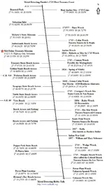
Underwater leases

There are leases covering all of Fort Pierce inlet to St. Lucie inlet. There are only a couple of spots south of Melbourne to St. Lucie Inlet that are not in a lease area.

If you want to know the current lease areas this would be a good contact:


Lindsay S. Smith, M.A., RPA
Underwater Archaeologist III
Bureau of Archaeological Research
1001 DeSoto Park Drive
Tallahassee, FL 32301
Fax: 850.245.6452
[email protected]
www.flheritage.com

I know you can hunt in the water in Jensen Beach in port st lucie and south, north of Jensen beach to Melbourne beach I hunt from mean low tide line to toe of dune....

Sent from my Galaxy Nexus using Tapatalk 2
 

I hunt the water at Jensen public beach when conditions aren't good for finding old items elsewhere.. never had any problem.
I chat with the lifeguards and police officers there often.
They always want to know what I found.
 

Last edited:
If you know borders of Palm Beach County, then you will understand this a little better..
This group also has been working north of WPB out from Juno Beach.
Getting a grant or having to search more north on a newly discovered, Thinking above Port St Lucie County, Is in the makings with the State
They just Won a lease for this back in June, Off Lanata Beach, Between West Palm and Boynton Beach..

Shipwreck Salvors, Seafarer, Get New Work

http://seafarercorp.com/press-release-november-12-2012/

This is the exact lease I got kicked off of thanks
 

They must be good at what they do....
You can buy their stock .02 cents a share.

But in all fairness odyssey only trades around $3.

I just dont like this whole lease deal.. scam whatever. .
 

Last edited:
They must be good at what they do....
You can buy their stock .02 cents a share.

But in all fairness odyssey only trades around $3.

I just dont like this whole lease deal.. scam whatever. .

If the leases weren't there, no one would be allowed to get near the wrecks. Check out Legare anchorage just south of Miami, the state doesn't want anyone near the wreck. No stopping, diving, snorkeling. All the restrictions are on the nautical chart. You wouldn't be able to get near the wrecks, never mind getting in the water with a metal detector. The leases provide legal access, but the state doesn't want anyone on the wrecks, so they make them impossible to obtain.
 

Unless they believe there's a high probability for profit.
 

Last edited:
There's the "Power Plant" lease area, south of that is the "unknown wreck" area and Jensen beach and south to St. Lucie Inlet is now an exploration lease it was obtained in 2012...
 

You seem to be looking at a chart of some kind.. why not just post it.
I happen to know the person with the exploration lease ..the state won't give a full up to date chart to them.
Only need to know info. based on their coordinates.
 

Last edited:
I posted the chart in other threads and this thread also.

Having been involved in professional 1715 fleet salvage for over 17 years I am very familiar with the leases and history. Most anyone that has looked at the research believes "something" lies south of our "unknown wreck" lease and it was only a matter of time before someone obtained a lease down there. My own interest in a lease for there led me to find out the July 2011 leases (which I've posted more than once) within the State of Florida excluding the Keys as that is different jurisdiction.

It's not a huge secret that 1715 Fleet Queens Jewels has the exploration lease south to St. Lucie Inlet.

"the state won't give a full up to date chart to them." - I'm not sure what that means.

I wouldn't rely on local LEO and lifeguards to be up to date on the legalities of Florida treasure hunting laws as we have seen it seems as if the State themselves has a variance of the law depending on who is contacted.

Again I would advise anyone that wants new updated information to use the contact information I posted above.
 

Oh believe me I didn't get that information from lifeguards or the police.
Queen's jewels.. does not own one continuous lease from the power plant area all the way to the St Lucie Inlet.
Like I said I am a personal acquaintance of a current lease holder. The requests were very recent for the up-to-date "active" lease boundaries..and only the info that would directly affect the interest of that lease holder was offered ..only after the coordinance of their lease was given to them.
Is the one you posted for this season?
I just went through every post of this thread... and saw nothing like that in one of your posts.
 

Last edited:
Something like this is easy to look up online.

ForumRunner_20130827_152802.png
 

They must be good at what they do....
You can buy their stock .02 cents a share.

But in all fairness odyssey only trades around $3.

I just dont like this whole lease deal.. scam whatever. .

I just emailed them asking about there lease in lantana and where it ends. Hopefully they will answer
 

The leases in the Sebastian area, to my knowledge have been sewn up since the late 60's and Moe has had some good success on some of these. Some of the the leases in the Boca Raton area, to best of my sources, are recent due to new interest on a few historical wrecks. My distant cousins dove off one at Boca more than 40 years ago and recovered cannon and such. I was contacted recently by a familiar name who showed interest in that and other wrecks, and who, most likely, is now involved in recent operations there. I wish them the best of luck. Would be fantastic if they could identify the wreck.
 

Now what is disturbing is the apparent secrecy from the state.........if they lease, it should be public for all to know.......and to avoid those areas and to seek other areas of "public", read state, land..........
Perhaps it is my ignorance of the topic, but I have difficulty understanding why the diffculty with getting info on this..........how else can we avoid leased areas.........
Seems to me nothing good comes from such secrecy and only serves to hide things........my guess anyway........
Those who are familar are welcome to shed some light on what may simply be my ignorance of finding info......
Thanks
 

doc-d,

I'm not sure what your post is about. I posted the contact information for the sate.

It's really very simple to send them a letter or email requesting what you are looking for. I did so in 2011 and received the lease map that I have posted in this thread and other threads.

Gator, I beleive I posted about the 2 leases south of the Power Plant lease, I don't recall calling it one continuous lease.

South of Fort Pierce Inlet to St. Lucie Inlet there are technically 6 leases, 5 of which are controlled by 1715 Fleet Queens Jewels and 1 by Blue Water Ventures of Key West which is between Douglas Beach site and the Power Plant site. The 3 most southern leases are Queens Jewel's

http://www.treasurenet.com/forums/shipwrecks/372156-underwater-leases-2.html#post3552155


http://www.treasurenet.com/forums/s...-besides-jupiter-inlet-lease.html#post3123272
 

TH, what is the mean low tide? How do you know where it is exactly?
 

I'll answer..hope that's OK.
"mean" is another word for average.
every tide cycle has a high and a low....high tide...and a high and low...low tide.
The tides are directly effected by the moon that creates a bigger monthly cycle of high and low that those fall within.
So..basically ..it's the area between the lowest low..and the highest low tide. The average low tide line.

I can't imagine it would be very easy to enforce that.. but technically speaking on a full moon tide ...at high tide depending on the contour of the beach you could be detecting in waist deep water and still be above the average low tide mark.
 

Last edited:
I'll answer..hope that's OK.
"mean" is another word for average.
every tide cycle has a high and a low....high tide...and a high and low...low tide.
The tides are directly effected by the moon that creates a bigger monthly cycle of high and low that those fall within.
So..basically ..it's the area between the lowest low..and the highest low tide. The average low tide line.

I can't imagine it would be very easy to enforce that.. but technically speaking on a full moon tide ...at high tide depending on the contour of the beach you could be detecting in waist deep water and still be above the average low tide mark.

Thanks, the way you explained this makes sense. So pretty much if detecting out of the water your all set right?

Sent from my SCH-R930 using Tapatalk 2
 

Yup..just don't go west of the base of the dunes.
 

Top Member Reactions

Users who are viewing this thread

Back
Top