The stone maps and their concept

Yes , I'm an English analphabet because all my life I was talking and writing another languages. I do my best and my friends, like me as I am and never complained of my typos. Nobody is perfect. Seems this is the only vulnerable point which someone can use to deride me.
I would welcome you in a Greek forum to see how you could make it there, but maybe this can occur only in a future life.

I never attempted to be the biggest and the lauder drum in the hall. I only wrote my opinions based in my research. I never wrote " I FOUND IT " like many others did and I keep a low profil.
If what I post is not enough for you, I'm sorry but I can't give away the coordinates for now.

Good bye!

Marius,

Not true.

Neither he or or anyone (including me) in this forum has ever derided you for being an "analphabet."

What he is saying is that if you want to be taken seriously and your opinions respected in this forum in regard to the Superstitions, you need to put boots to ground, and post legible pictures that are clearly from the Superstition mountains, not pictures borrowed or outright stolen (as when you stole one of his), or blurry google map stills.

Until then, post away but don't expect to be taken seriously.

All the pics in this thread are from Superstitions mountains Arizona.
Everyone is free to take my opinions and pics like he wants. You ( all )must to thank God you have the opportunity to see pictures of things that you maybe would never see. Only this.
 

Last edited:
All the pics in this thread are from Superstitions mountains Arizona.
Everyone is free to take my opinions and pics like he wants. You ( all )must to thank God you have the opportunity to see pictures of things that you maybe would never see. Only this.

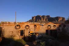
I hope that someday, you make the trip out to the Superstitions. It will be a trip well worth it. Those mountains are beautiful and my favorite time to be out there is at twilight when the mountains are at their most mystical.

DSC01765.jpg
 

Yes , I'm an English analphabet because all my life I was talking and writing another languages. I do my best and my friends, like me as I am and never complained of my typos. Nobody is perfect. Seems this is the only vulnerable point which someone can use to deride me.
I would welcome you in a Greek forum to see how you could make it there, but maybe this can occur only in a future life.

I never attempted to be the biggest and the lauder drum in the hall. I only wrote my opinions based in my research. I never wrote " I FOUND IT " like many others did and I keep a low profil.
If what I post is not enough for you, I'm sorry but I can't give away the coordinates for now.

Good bye!

I'll have to try a translation of my own writing to Greek sometime.....to see if "spellcheck" picks up on any mistakes I'm certain to make.
It certainly works well, and often, while I'm typing in my native North American English. Just so happened I had been looking at a list of writer/editor abbreviations prior to posting here and came across "sic", which I hadn't seen used anywhere for some time, let alone on this or other blogs.
Just thought I would add those two flags, more as a little piece of "trivia" which our followers could themselves Google if curious...as I myself had to do with "analphabet"....than any dig at you. It was a "golden" opportunity, so to speak. Since you've never claimed to be a superior writer, I really don't mind any spelling or grammar mistakes you happen to make....in any language.
I find it kind of interesting how, even in major media outlets, spelling mistakes are becoming ever more common....while the inclusion of flags such as [sic] have almost disappeared .
I hope it doesn't start going that way with any new books I should choose to buy and read. That would (literally) drive me 'round [sic] the bend.
crazed writer.jpg

BTW....I'm not asking for your co-ordinates. And I haven't seen anyone else asking either.
Pretty sure we all have our own locations in mind, as to where the good stuff really is.
No need for anyone to be sorry about that.
 

Last edited:
If you have finished your opinions, we can continue with the stone maps concept.
 

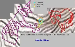
I will make a sketch with the horse and priest landmarks using the first image of this thread, to see how large are the hearts in comparison with these landmarks. As I wrote the only heart visible is that mentioned in the priest stone map.
 

As I wrote, I will post a map made by me, which shows how are located the Horse landmark ( depicted in the Horse stone map ) and the Priest landmark ( depicted in the Priest stone map ) in regards to the Trail heart ( depicted in the upper stone trail map ), Latin heart ( known as the Latin stone heart map ) and the Trail ( depicted in the Trail stone maps ).

This map, like that from the first post of this thread, is a treasure by itself and every person who is interested in the stone maps riddle have to has it in his/her collection.

The Trail heart is about 32 yards large, so you can make an estimation of how large are the Horse and the Priest landmarks.

map.jpg

Have a nice day!
 

Last edited:
I see in another thread, people are arguing on what the numbers 1847 on the stone maps would mean. I will write what these numbers are for, conclusion which I made after doing my research.
You will see after reading my conclusion how all the stone tablets are close related to each other and indispensable. And here we are:

-The numbers 1847 in the heart cavity, if will be read in a specific order using mathematic, they will show the degrees and the distance in varas, from a specific point/landmark to the heart. Here I want to clear out how what I mean " heart ", I am talking about the only heart visible at the spot, and this is the heart on the Warrior's face.

-The 1847 at the base of the Priest, if will be read in a specific order, they will show the distance in varas from the heart to the maps ( where they were stored in the past ) and the starting point of the Trail.

- The riddle written on the lower ( DON ) stone Trail map, if will be read in a specific order, will shows the degrees from the heart to the maps and the starting point of the Trail.

That's it. Food for thoughts.
 

Last edited:
Some things make u go hmm . Sphynx ??View attachment 1746090

The Sphinx clue is related to the LDM topic and is what John Reed had recognized with his childish imagination at the LDM inclined shaft region. This clue is not so accurate because everyone could see different shapes in rock formations and was not told by others trying to describe the region.
 

The Sphinx clue is related to the LDM topic and is what John Reed had recognized with his childish imagination at the LDM inclined shaft region. This clue is not so accurate because everyone could see different shapes in rock formations and was not told by others trying to describe the region.[/QUOTE


Gotta say tho. Does look like a sphynx.! Yea?? I'd remember it. Lol
 

Markmar has not sunk in yet has it. The stones are only Travis artwork. You need to look at what was his inspiration


And the numbers at the bottom?

They just happen to not add up, but somehow they list the Beale Mining Party's times spent there precisely?

And the 30 men missing in the Beale?

They were 30 different men lost 300 miles from Santa Fe right?

The 30 Skeletons that were found in the valley, with nuggets surrounding them, with their gold lifted?

They were killed with bows and arrows by the Apache Thunder God?

The stories we could tell.....:laughing7:

Maybe we should start calling this the Lost Dutchmen....?

Are you in?
 

"Personally I feel very succesful [sic] in what I have planed [sic] to do."

Simply attempting to be the biggest drum in the concert hall is not enough......

Works fine for me.....

giphy.gif
 

I will make a sketch with the horse and priest landmarks using the first image of this thread, to see how large are the hearts in comparison with these landmarks. As I wrote the only heart visible is that mentioned in the priest stone map.


Too late ..... pack it up boys.....Eldorado's here

CobolloSideBySide.jpg
 

Too late ..... pack it up boys.....Eldorado's here

View attachment 1774286

Eldorado could be, but for sure not the treasure and the horse of Santa Fe.
IMHO, the horse landmark is not a mountain and could not be seen from above as a GE image. The Horse of Santa Fe is a landmark which could be seen only from the side and from a specific point at a specific time of the day.
If someone will tell you otherwise, then is in the wrong place.
 

Last edited:
The horse's tail represents the river. Just look at it. It is a river. It shows the canyon you go through and even the slashes tell you how far it is. The two E's, one high and one low, tell you that you would be on the east side of the canyon wall. Going down to the lower E shows that going down hill, you are heading east. It is 0.36 of a nautical mile from the bottom of the canyon up to the mine. That is to scale on the stone map if you use the correct measuring tool. But first, you have to know where you are. When it comes to this mine, no one will ever know where they are because one map is missing. That is unless you understand what the stone crosses are telling you. The Stone Maps are the real deal.
 

The horse's tail represents the river. Just look at it. It is a river. It shows the canyon you go through and even the slashes tell you how far it is. The two E's, one high and one low, tell you that you would be on the east side of the canyon wall. Going down to the lower E shows that going down hill, you are heading east. It is 0.36 of a nautical mile from the bottom of the canyon up to the mine. That is to scale on the stone map if you use the correct measuring tool. But first, you have to know where you are. When it comes to this mine, no one will ever know where they are because one map is missing. That is unless you understand what the stone crosses are telling you. The Stone Maps are the real deal.

I agree the stone maps are real, but to can decrypt them, someone has to know Spanish treasure codes. If he knows to distinguish constellations and knows how to angram them with numbers and symbols, is a matter of hours using the GE software or a matter of days in the fields to find out where the Horse of Santa Fe landmark lies.
IMHO, the horse's tail is just a " tail " and is what had seen the outhor of the stone maps in the mountaiside's relief.

You both are right about some. But not all of it. U will know when your there.
 

Top Member Reactions

Users who are viewing this thread

Back
Top