You are using an out of date browser. It may not display this or other websites correctly.
You should upgrade or use an alternative browser.
You should upgrade or use an alternative browser.
The Square Round Table
- Thread starter L.C. BAKER
- Start date
franklin
Gold Member
- Joined
- Jun 1, 2012
- Messages
- 5,018
- Reaction score
- 7,151
- Golden Thread
- 0
- Detector(s) used
- Garrett ADS-7X, Fisher Two Box M-Scope, Mother Lode Locator, Dowsing Model 20 Electroscope, White's TM808, White's TM900, Inground Scanners
- Primary Interest:
- All Treasure Hunting
The pirates wore an eye patch. Wonder why so many are depicted with eye patches? It was not because they all had an eye missing or blind in the eye, does anyone know why? THEY DID IT so when they went below deck they could raise the patch and see what was going on down below. Otherwise they would be in the dark.
Rebel - KGC
Platinum Member
LOL!
Ryano
Hero Member
- Joined
- Feb 16, 2014
- Messages
- 760
- Reaction score
- 1,284
- Golden Thread
- 0
- Location
- St. Augustine, FL
- Primary Interest:
- Cache Hunting
Barn - get you a "borescope"
Inexpensive and can work with iPhone or android phones. Take a peek down that hole ! Lots of models to choose from on Amazon
https://www.amazon.com/Depstech-Sem...Smartphone/dp/B0785H3XR7?tag=treasurenet01-20
Inexpensive and can work with iPhone or android phones. Take a peek down that hole ! Lots of models to choose from on Amazon
https://www.amazon.com/Depstech-Sem...Smartphone/dp/B0785H3XR7?tag=treasurenet01-20
Last edited:
barnhse
Full Member
Barn - get you a "borescope"
Inexpensive and can work with iPhone or android phones. Take a peek down that hole ! Lots of models to choose from on Amazon
https://www.amazon.com/Depstech-Sem...Smartphone/dp/B0785H3XR7?tag=treasurenet01-20
I guess that would be worth a try, Ryano.
I worry that the muddy silt would cover up whatever I hit.
I will get one...can't hurt, might help.

Ryano
Hero Member
- Joined
- Feb 16, 2014
- Messages
- 760
- Reaction score
- 1,284
- Golden Thread
- 0
- Location
- St. Augustine, FL
- Primary Interest:
- Cache Hunting
Reminds me of going to the dentist: the Doc is drilling away on your tooth while the assistant is keeping the work site clean with a water gun and vacuum hose.. if only you had an all-one- tool that did all that  . Good luck
 . Good luck
Kace
Bronze Member
- Joined
- Aug 15, 2017
- Messages
- 2,097
- Reaction score
- 4,903
- Golden Thread
- 0
- Detector(s) used
- Whites DFX, Whites Bullseye 2 Pointer, Audio 200 D Headphones,
Garrett AT MAX, Garrett Pro-Pointer AT, MS-3 Headphones,
Lesche Digger, Lesche Shovel, 4' T Handle Probe.
GoPro, RC Truck, Drone.
- Primary Interest:
- Other
The pirates wore an eye patch. Wonder why so many are depicted with eye patches? It was not because they all had an eye missing or blind in the eye, does anyone know why? THEY DID IT so when they went below deck they could raise the patch and see what was going on down below. Otherwise they would be in the dark.
You're the second person I've heard explain that! Makes perfect sense!!
Kace
Rebel - KGC
Platinum Member
AHOY!
barnhse
Full Member
Hi All,
Man, am I tired.
I dug another 9 ft 8 in hole, and I hit something hard at the same level as my other two holes.
I really do think it is concrete.
It is definitely not wood or a tree or a rock.
The wife wants me to do stuff tonight, so I will have to post my findings and pics tomorrow or Tuesday.
I can show you all what I did, and the logic of why I believe I hit concrete.
"Life is one long process of getting tired."
Samuel Butler
barnhse
Full Member
Hi All,
Last weekend I found out (to my satisfaction anyway) that the two holes where the rented magnetometer said to dig actually pointed to
a concrete retaining wall in the man-made hill in the marsh.
I won't play the sad violin by telling you all the troubles I had digging and stuff, other than to say wiser and smarter men wouldn't have gone through all the stuff I did last weekend.
I will just say, I dug a THIRD hole...and it hit something hard at the same place my other two holes stopped at.
Here are some pics:
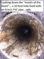
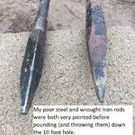
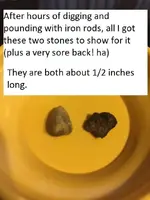
The above stones are stones like the stones in a couple of other concrete slabs I saw in the marsh over my last 3+ years of searching.
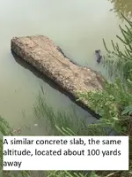
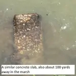
So, even though I didn't find the safes, I am just going to stop looking in the salt marsh, at least until I get my two-box metal detector.
I plan on getting a
Whites TM 808
3.62 pounds
$729
https://www.amazon.com/Whites-TM-808-Metal-Detector/dp/B00B2B4NVI/?tag=treasurenet01-20
It'll take me months to hide enough quarters from my wife to afford it.
Then I probably will go back and see if it can discriminate, so I don't have to dig just for concrete slabs or rocks.
Also, I can use the two-box detector for my next quest.
“It's a long, arduous road he's starting to travel, but it may be that at the end of it he'll find what's he's seeking.”
― Somerset Maughm, The Razor's Edge
(key words are "may be"...ha)
Barn
Last weekend I found out (to my satisfaction anyway) that the two holes where the rented magnetometer said to dig actually pointed to
a concrete retaining wall in the man-made hill in the marsh.
I won't play the sad violin by telling you all the troubles I had digging and stuff, other than to say wiser and smarter men wouldn't have gone through all the stuff I did last weekend.
I will just say, I dug a THIRD hole...and it hit something hard at the same place my other two holes stopped at.
Here are some pics:


The above stones are stones like the stones in a couple of other concrete slabs I saw in the marsh over my last 3+ years of searching.


So, even though I didn't find the safes, I am just going to stop looking in the salt marsh, at least until I get my two-box metal detector.
I plan on getting a
Whites TM 808
3.62 pounds
$729
https://www.amazon.com/Whites-TM-808-Metal-Detector/dp/B00B2B4NVI/?tag=treasurenet01-20
It'll take me months to hide enough quarters from my wife to afford it.
Then I probably will go back and see if it can discriminate, so I don't have to dig just for concrete slabs or rocks.
Also, I can use the two-box detector for my next quest.
“It's a long, arduous road he's starting to travel, but it may be that at the end of it he'll find what's he's seeking.”
― Somerset Maughm, The Razor's Edge
(key words are "may be"...ha)
Barn
Last edited:
Ryano
Hero Member
- Joined
- Feb 16, 2014
- Messages
- 760
- Reaction score
- 1,284
- Golden Thread
- 0
- Location
- St. Augustine, FL
- Primary Interest:
- Cache Hunting
Well... damn. That sucks.
What's the story with this man-made hill and buried concrete wall ? Isn't this land you're on out in the middle of nowhere ?
What's the story with this man-made hill and buried concrete wall ? Isn't this land you're on out in the middle of nowhere ?
barnhse
Full Member
Well... damn. That sucks.
What's the story with this man-made hill and buried concrete wall ? Isn't this land you're on out in the middle of nowhere ?
Hi Ryano,
I started my search in Feb 2015.
I found land that was owned by a high level KGC person after the civil war (confirmed by L.C.).
And the land was even mentioned in the "Jesse James Was One Of His Names" book. (maybe fiction, but interesting nonetheless)
The marsh is about 1/2 mile square.
I walked almost every yard of the marsh.
I found where the road moved twice over the last 150 years.
In the story, the wagons with the gold hidden in hollowed-out cypress logs were searched twice by Union soldiers en route.
So I assumed that since they were hiding from the soldiers that they hid the safes undercover of small hills and trees.
Therefore, I zoomed in where the trees were.
The story even said they hid the safes in the woods and waited until the gold arrived in the wagons.
I figured the trees now were at least where the trees were in 1870.
I found the only hill formation that matched the hand-drawn treasure map.
My research led me to a couple of key maps that I used.
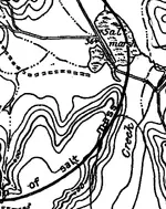
This topo map was in a report that was dated 1917.
The 364 is the elevation on the topo map.
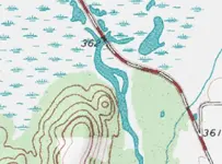
This other topo map is from 1958.
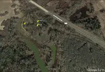
This is how my search area looks today.
The yellow line is a high bank that hides the target area from being seen from the big flat area and from the road.
The 368 is a four foot bank (four feet higher than the 364 in the 1917 topo map), and confirmed by Google Earth.
If I overlay the three maps above, they look like this.
The MN 9.52E is the magnetic north point in 1870 from the small peak "landmark" (they uses compasses in 1870 y'know)...I found pretty interesting that another member in this forum who douses thought the safes were located along this magnetic north line (he didn't know his spot was exactly on the magnetic north line)...once I get my two-box metal detector I will search more there.
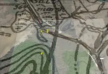
You can see where they moved the creek (between 1917 and 1958) here.
This is where I believe they installed some little concrete "banks" to make the creek flow a different way to move the creek.
There were some areas along here where there are no trees now, so I think they tried to control the creek in order to try to farm some of the land along here. (obviously they failed)

Then after 1958, they made the creek flow differently by putting up a little man-made hill (embankment) here.
It is a straight line hill.
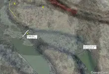
Does that help Ryano?
Barn
Last edited:
Kace
Bronze Member
- Joined
- Aug 15, 2017
- Messages
- 2,097
- Reaction score
- 4,903
- Golden Thread
- 0
- Detector(s) used
- Whites DFX, Whites Bullseye 2 Pointer, Audio 200 D Headphones,
Garrett AT MAX, Garrett Pro-Pointer AT, MS-3 Headphones,
Lesche Digger, Lesche Shovel, 4' T Handle Probe.
GoPro, RC Truck, Drone.
- Primary Interest:
- Other
WOW! Just WOW!! I was hoping you'd find those Barn!
You've got more determination and drive than anyone I've ever seen or heard of on a project like this...And the brute strength you've put into this by yourself is just Amazing!
I've Loved Seeing The Updates and Following Along!
Regardless of my views on the source of this story...You're An Exemplary Example of a Man Among Men in my thoughts, Barn.
You'll have to let us know what you've decided your next Adventure will be!
Kace
You've got more determination and drive than anyone I've ever seen or heard of on a project like this...And the brute strength you've put into this by yourself is just Amazing!
I've Loved Seeing The Updates and Following Along!
Regardless of my views on the source of this story...You're An Exemplary Example of a Man Among Men in my thoughts, Barn.

You'll have to let us know what you've decided your next Adventure will be!
Kace
Last edited:
L.C. BAKER
Silver Member
- Joined
- Sep 9, 2012
- Messages
- 3,805
- Reaction score
- 4,644
- Golden Thread
- 0
- Location
- Nebraska City, Nebraska
- Primary Interest:
- Other
- #336
Thread Owner
BTW, speaking of pirates, I got a shirt like this a couple of years ago.
View attachment 1633782
Barn
WELL SAID!

L.C. BAKER
Silver Member
- Joined
- Sep 9, 2012
- Messages
- 3,805
- Reaction score
- 4,644
- Golden Thread
- 0
- Location
- Nebraska City, Nebraska
- Primary Interest:
- Other
- #337
Thread Owner
Hi All,
Man, am I tired.
I dug another 9 ft 8 in hole, and I hit something hard at the same level as my other two holes.
I really do think it is concrete.
It is definitely not wood or a tree or a rock.
The wife wants me to do stuff tonight, so I will have to post my findings and pics tomorrow or Tuesday.
I can show you all that I did, and the logic of why I believe I hit concrete.
"Life is one long process of getting tired."
Samuel Butler
Do you think this would do you any good on the end of a tent pole or some kind of rod? Says its waterproof even, and it seemed to be reasonably priced. https://www.tmart.com/1200P-IP68-8-...MI89mxmZXd3QIVgh5pCh1aywRDEAQYAiABEgL2l_D_BwE
Great Effort Barn! I hope you succeed and find something big!
L.C.
Last edited:
L.C. BAKER
Silver Member
- Joined
- Sep 9, 2012
- Messages
- 3,805
- Reaction score
- 4,644
- Golden Thread
- 0
- Location
- Nebraska City, Nebraska
- Primary Interest:
- Other
- #338
Thread Owner
Hi All,
Last weekend I found out (to my satisfaction anyway) that the two holes where the rented magnetometer said to dig actually pointed to
a concrete retaining wall in the man-made hill in the marsh.
I won't play the sad violin by telling you all the troubles I had digging and stuff, other than to say wiser and smarter men wouldn't have gone through all the stuff I did last weekend.
I will just say, I dug a THIRD hole...and it hit something hard at the same place my other two holes stopped at.
Here are some pics:
View attachment 1635734
View attachment 1635735
View attachment 1635736
The above stones are stones like the stones in a couple of other concrete slabs I saw in the marsh over my last 3+ years of searching.
View attachment 1635738
View attachment 1635739
So, even though I didn't find the safes, I am just going to stop looking in the salt marsh, at least until I get my two-box metal detector.
I plan on getting a
Whites TM 808
3.62 pounds
$729
https://www.amazon.com/Whites-TM-808-Metal-Detector/dp/B00B2B4NVI/?tag=treasurenet01-20
It'll take me months to hide enough quarters from my wife to afford it.
Then I probably will go back and see if it can discriminate, so I don't have to dig just for concrete slabs or rocks.
Also, I can use the two-box detector for my next quest.
“It's a long, arduous road he's starting to travel, but it may be that at the end of it he'll find what's he's seeking.”
― Somerset Maughm, The Razor's Edge
(key words are "may be"...ha)
Barn
You will like it Barn, ours has a cave mode and we use a geologger hooked to the Whites, but it takes time to lay it out and run a grid and then wait until we get home to look at the computer to see if we saw anything interesting,. I wish we had real-time capability for ours so we could watch it on a laptop as we run the detector with the geologger. We are still learning what to do as we go, but we are getting better and faster at it. The real-time software would be a nice addition I think. Barn it is all progress and exciting no matter what it pays, but I hope you find the safes.
L.C.
Last edited:
L.C. BAKER
Silver Member
- Joined
- Sep 9, 2012
- Messages
- 3,805
- Reaction score
- 4,644
- Golden Thread
- 0
- Location
- Nebraska City, Nebraska
- Primary Interest:
- Other
- #339
Thread Owner
WOW! Just WOW!! I was hoping you'd find those Barn!
You've got more determination and drive than anyone I've ever seen or heard of on a project like this...And the brute strength you've put into this by yourself is just Amazing!
I've Loved Seeing The Updates and Following Along!
Regardless of my views on the source of this story...You're An Exemplary Example of a Man Among Men in my thoughts, Barn.
You'll have to let us know what you've decided your next Adventure will be!
Kace
Even if the story is not true about the safes, the land he is searching on is a prime spot to look for something that may have been left by people who had enough to leave some buried in the ground for a rainy day.
L.C.
Kace
Bronze Member
- Joined
- Aug 15, 2017
- Messages
- 2,097
- Reaction score
- 4,903
- Golden Thread
- 0
- Detector(s) used
- Whites DFX, Whites Bullseye 2 Pointer, Audio 200 D Headphones,
Garrett AT MAX, Garrett Pro-Pointer AT, MS-3 Headphones,
Lesche Digger, Lesche Shovel, 4' T Handle Probe.
GoPro, RC Truck, Drone.
- Primary Interest:
- Other
You will like it Barn, ours has a cave mode and we use a geologger hooked to the Whites, but it takes time to lay it out and run a grid and then wait until we get home to look at the computer to see if we saw anything interesting,. I wish we had real-time capability for ours so we could watch it on a laptop as we run the detector with the geologger. We are still learning what to do as we go, but we are getting better and faster at it. The real-time software would be a nice addition I think. Barn it is all progress and exciting no matter what it pays, but I hope you find the safes.
L.C.
Is that something he can do alone? You said We several times is why I asked.
Kace
Similar threads
Users who are viewing this thread
Total: 1 (members: 0, guests: 1)


