You are using an out of date browser. It may not display this or other websites correctly.
You should upgrade or use an alternative browser.
You should upgrade or use an alternative browser.
The Peralta Stones
- Thread starter gollum
- Start date


gollum
Gold Member
- Joined
- Jan 2, 2006
- Messages
- 6,770
- Reaction score
- 7,734
- Golden Thread
- 0
- Location
- Arizona Vagrant
- Detector(s) used
- Minelab SD2200D (Modded)/ Whites GMT 24k / Fisher FX-3 / Fisher Gold Bug II / Fisher Gemini / Schiebel MIMID / Falcon MD-20
- Primary Interest:
- All Treasure Hunting
- #2,902
Thread Owner
cactusjumper said:Mike,
That's a pretty good list, but Robert Blair's "Tales of the Superstitions" surely has to be in the top four.
I have a couple of copies of "The Killer Mountains", one is inscribed to Gentry's "Mom". Nice little note to the lady.
It's a great read but, personally, I would not place it in the top five or six. Too much fluff in the book for my taste. I spoke on the phone with one of Magill's team members at last years Rendezvous. The Rendezvous is an event that no Dutch Hunter should miss. Just too much history in one camp on that weekend.
Take care,
Joe
Joe,
So now I know why you say looking for the LDM was never a priority for you. If you believe Blair, you don't think Waltz ever had a mine in the Supers. You must, since you put it in your top four.
Now, I like reading opposing viewpoints, buuuuuuuut, like the discussion I had with Shortstack, outdated information can many times be worse than unsubstantiated rumors. See, Shortstack firmly believed what his friend Karl von Mueller told him. That it was his expert opinion that Waltz' Gold came from high grading the Vulture Mine. That theory was absolutely discredited by Thomas Glover in 1991.
I am very glad I read several other books on the DLM before reading Blair's. What I noted were some GLARING omissions by Blair that didn't fit in with his hypothesis that the DLM was nothing more than a story Waltz made up to get free room and board from Julia Thomas in his last months on earth.
I will show just a few:
1. Blair seems to have missed when the "pauper" Waltz gave Julia enough gold ore to pay off the debt on her Ice Cream maker. What was that? $1400-$1700 (I don't have a book open in front of me).
2. He also seemed to miss the part about the $4000 worth of ore Dick Holmes got from the candlebox under Waltz' death bed. One day he was poor, then right after Waltz died, he bought a house and had money. HMMMMMMMMMMMMM
3. He followed the trail to California of the wrong branch of the Peralta Family. The branch he followed left Sonora in 1776 with Capt. Juan Bautista de Anza.
4. He claims that Ely got most of his Waltz Stories from Weedin. That is absolutely untrue. Ely got the stories from several interviews with Julia Thomas, and Jim Barks interviews with Rhiney Petrasch. On a com,ical note here, he also questions why Ely would wait until such an old age to publish his story. HAHAHA Does he REALLY not know that? Does he REALLY not understand why a man who had been looking for the DLM since before the turn of the last century would not publish his findings while still actively searching?
When such omissions as these kept popping up time and again, I wanted to just put the book down, but I read it all the way through. I will give some credit to a lot of the facts he found, but everything he did, he did trying to prove a preconceived idea that the only mines the Peraltas ever had were in the Bradshaws (Valenciana and Gloriana). While I wouldn't call his book garbage, I definitely would NEVER put it in my top four.
Best-Mike
Cubfan64
Silver Member
- Joined
- Feb 13, 2006
- Messages
- 3,001
- Reaction score
- 2,858
- Golden Thread
- 0
- Location
- New Hampshire - USA
- Detector(s) used
- Fisher CZ21, Teknetics T2 & Minelab Sovereign GT
- Primary Interest:
- All Treasure Hunting
Mike and Joe,
I may be mistaken, but I think I remember Jack San Felice a couple years ago at the Rendezvous mentioning that he went back and read the notes, drafts and other assorted things in the Robert Blair Collection at the ASU Hayden library and that they gave a different impression than what Blairs final book seemed to imply.
I don't remember Jack mentioning any specifics, but I've kept that in the back of my mind as something to look into one of these days.
Just a thought.
cactusjumper
Gold Member
Mike,
"So now I know why you say looking for the LDM was never a priority for you. If you believe Blair, you don't think Waltz ever had a mine in the Supers. You must, since you put it in your top four."
I have mentioned before that I don't agree with Blair's conclusions, but his research was very good. Did he get some things wrong.....of course. Every author who ever wrote about the LDM made some mistakes and that includes Dr. Glover.
I have always believed that Waltz had a mine in the Superstitions. After you have read the evidence, man would have to be a fool to believe otherwise. In the begining, I was searching for Jesuit treasure, like a number of other well know Dutch Hunters. Once I put aside that childish notion due to years of research into the subject, I concentrated on the Harry LaFrance cave of gold bars. I don't know for a fact that Harry's story is true, but I do know that he had a gold bar. That's something that can't be put aside no matter how much research is done.
The Stone Maps were a big part of my search.
Mike, you tend to make some mighty leaps of logic. Don't make a big issue out of what you think I think. Nothing is more important than your own conclusions. I have never said that Waltz didn't have a mine in the Supe's.
Take care,
Joe
"So now I know why you say looking for the LDM was never a priority for you. If you believe Blair, you don't think Waltz ever had a mine in the Supers. You must, since you put it in your top four."
I have mentioned before that I don't agree with Blair's conclusions, but his research was very good. Did he get some things wrong.....of course. Every author who ever wrote about the LDM made some mistakes and that includes Dr. Glover.
I have always believed that Waltz had a mine in the Superstitions. After you have read the evidence, man would have to be a fool to believe otherwise. In the begining, I was searching for Jesuit treasure, like a number of other well know Dutch Hunters. Once I put aside that childish notion
due to years of research into the subject, I concentrated on the Harry LaFrance cave of gold bars. I don't know for a fact that Harry's story is true, but I do know that he had a gold bar. That's something that can't be put aside no matter how much research is done.The Stone Maps were a big part of my search.
Mike, you tend to make some mighty leaps of logic. Don't make a big issue out of what you think I think. Nothing is more important than your own conclusions. I have never said that Waltz didn't have a mine in the Supe's.
Take care,
Joe
gollum
Gold Member
- Joined
- Jan 2, 2006
- Messages
- 6,770
- Reaction score
- 7,734
- Golden Thread
- 0
- Location
- Arizona Vagrant
- Detector(s) used
- Minelab SD2200D (Modded)/ Whites GMT 24k / Fisher FX-3 / Fisher Gold Bug II / Fisher Gemini / Schiebel MIMID / Falcon MD-20
- Primary Interest:
- All Treasure Hunting
- #2,905
Thread Owner
Joe,
If I was mistaken about your feelings on the subject, I apologize. There are a ton of books on the DLM, and to put so much faith in one as to put it in your top four (above say Gentry's Killer Mountains), it is only natural to assume you put some stock in his conclusions. That, my friend, does not take a great leap of faith or logic.
Granted, Blair did a lot of research, but he did so trying to bolster a wrong theory. In doing so, he completely omitted so much contradictory evidence that it made the rest of his work look shoddy. The ONLY person making any "leaps of logic" was Blair.
Now, the Harry LaFrance Cave of Gold Bars is one of those stories that definitely does not get enough play. I remember you posting about it before (I don't remember if it was here or the LDM Forum). Do you think LaFrance actually recovered the bars? I can't imagine an open cave like that not being found by now in the Supers.
Best-Mike
Twisted Fork
Hero Member
Blindbowman said:there is a easy way to prove i am right . if i was correct and the gold from Tayopa was shipped to Spain in 1622 on the Atocha . then if any gold ore was shipped from the MA it would out right match the gold on the Atocha . now unless Waltz had a time machine ,, he can not possibly give his gold to the Atocha can he ...? i think that would be prove the mine Waltz was high grading is in fact the Ma mine .. the fact is all gold has its own assay of purity and i will bit anyone that some of the Atocha gold came from the Ma mine ...
any assayer can tell you if this is true or not ... get a sample of the Atocha gold and see if it matches the Waltz 's gold ...
i already know the answer to that question ...
Much of the confusion here is based on the simple fact that time has forgotten the vast territory that the Peraltas were working with. They worked the very richest mines alone and only earmarked various lodes along the trail. This is why various individuals and authors as well, have become confused as to where one mine or the other is truly located.
They were required to set up their monuments and conceal each of the mines that they wished to retain by title; according to the standards set upon them by the powers that be. 18 feet of tunnel, had to be excavated within three months of their initial discovery or else another Don would be able to put a lean on the dig and take it from them.
The Peraltas field filed claims on a chain of mines that began in Mexico and finished as far North as the tip of Idaho. Their sign can be found in every mining district along the way. Their main red heart stone was located in the Western desert of Utah in 1996, on a now closed gold mine some 50 miles or so North of the old Pony Express station located at Simpson Springs. Early pioneers know as the Danites, found one of their mines around 1847, mined as much as they could carry and headed for present day Mesa, Arizona, tracking the Peraltas down to the placer, miles South of the funnel pit mine.
To this day, the Peralta stone bread trail is still intact surviving lighting strike fires and whatever else that mother nature has dished out since then. Abe Lincoln said himself some years later, that Utah was the treasure house of the nation, after a federally funded expedition of geologists searched the area as they followed the old pack train trails of these illusive Dons and their mining parties.
A now deceased author by the name of George Thompson, worked side by side with Mel Fischer in the search for evidence of the source of gold that was found in the famous shipwreck; Here in Utah, in the Uinta Mnts., gold caches were located near mining sites and chemical tests proved that Utah was indeed involved collectively in the treasures found on the ocean floor.
Attachments
Twisted Fork
Hero Member
Right there indeed. It is more probable that Thompson contacted Fischer rather than otherwise. I was in contact with Thompson several days before his unexpected passing; he was sent photo evidence of Carrie Shin Ob, a once lost Ute Gold mine along the trail at Spanish Fork, Utah. Arrangements were being made through his publisher for him to go on site with our crew. This place truly gives one the creeps to say the least. The whole deal scared the crap out of us.
You know the dutchman was a great contributor and even more so the tunnel that was mined over a mile down wind; Spill from the main outcrop. There has been more than one funnel located in Arizona in the last 100 years. Probably all Peralta digs I suppose. Stone and plant markers are generally arranged some 47 to 65 miles apart with this system and the map to the mine one is looking for, is laid out on the ground at the outer edge of the previous mine and thus the confusion, Mnt. to Mnt.site. This is the legend box like you see on todays road maps. Scale changes every time, but the map retains it's format as it is traced, read backwards, inverted, turned at a right angle or counter-clockwise and upside down as well. North is really East as it is drawn and the marker sets are positioned differently as the terrain requires site to site. Fun huh? Well Oh man..... They didn't want us white folk to find them for nothing.
You know the dutchman was a great contributor and even more so the tunnel that was mined over a mile down wind; Spill from the main outcrop. There has been more than one funnel located in Arizona in the last 100 years. Probably all Peralta digs I suppose. Stone and plant markers are generally arranged some 47 to 65 miles apart with this system and the map to the mine one is looking for, is laid out on the ground at the outer edge of the previous mine and thus the confusion, Mnt. to Mnt.site. This is the legend box like you see on todays road maps. Scale changes every time, but the map retains it's format as it is traced, read backwards, inverted, turned at a right angle or counter-clockwise and upside down as well. North is really East as it is drawn and the marker sets are positioned differently as the terrain requires site to site. Fun huh? Well Oh man..... They didn't want us white folk to find them for nothing.
mrs.oroblanco
Silver Member
- Joined
- Jan 2, 2008
- Messages
- 4,356
- Reaction score
- 427
- Golden Thread
- 0
- Location
- Black Hills of South Dakota
- Detector(s) used
- Tesoro Lobo & Garrett Stinger
- Primary Interest:
- All Treasure Hunting
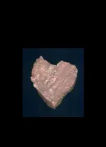
There's thousands of pieces like that rock in my back yard - maybe the Peralta's were here, too.
Please, please, please - someone give me some rational (note the word "rational") explanation of why ANYONE would EVER think that the Peralta
Stones are even a part of the Peralta saga
Beth
Please, please, please - someone give me some rational (note the word "rational") explanation of why ANYONE would EVER think that the Peralta
Stones are even a part of the Peralta saga
Beth
gollum
Gold Member
- Joined
- Jan 2, 2006
- Messages
- 6,770
- Reaction score
- 7,734
- Golden Thread
- 0
- Location
- Arizona Vagrant
- Detector(s) used
- Minelab SD2200D (Modded)/ Whites GMT 24k / Fisher FX-3 / Fisher Gold Bug II / Fisher Gemini / Schiebel MIMID / Falcon MD-20
- Primary Interest:
- All Treasure Hunting
- #2,909
Thread Owner
Beth,
I don't believe there is any connection, but:
1. 1847
2. Miguel on top of horse/witch stone
3. Pedro on horse's haunch
4. text in Spanish
5. Many Spanish Symbols used
6. Proximity (Peralta Mine Legends in Supers and these mystery stones with no provenance)
7. Wishful thinking
Best-Mike
I don't believe there is any connection, but:
1. 1847
2. Miguel on top of horse/witch stone
3. Pedro on horse's haunch
4. text in Spanish
5. Many Spanish Symbols used
6. Proximity (Peralta Mine Legends in Supers and these mystery stones with no provenance)
7. Wishful thinking
Best-Mike
Twisted Fork
Hero Member
Simply compare the paper Peralto maps to the tablets and look for comparable shape matching in the graphics, one to the other. You will soon see that they are one in the same art, even if they were done years apart from each other. You guys have got to get it straight in your heads that the Salt River is the key through and through. This is a Masonic code that has been handed down over many, many generations and lodges. It is privileged information shared with royalty and bloodlines there of.
Of course the trail starts in one's mind, from anywhere in the world, in the hands of one who knows where the Holy Land is first located. The quads are enclosed. Lay your ruler across them; The cross of Christ is the key to understanding. Since the tablets were obviously found on the trail, and 1847 is the year of war and death to their secret world in Arizona, What better way to say it than with a headstone; the first and the last is the answer.
Of course the trail starts in one's mind, from anywhere in the world, in the hands of one who knows where the Holy Land is first located. The quads are enclosed. Lay your ruler across them; The cross of Christ is the key to understanding. Since the tablets were obviously found on the trail, and 1847 is the year of war and death to their secret world in Arizona, What better way to say it than with a headstone; the first and the last is the answer.
mrs.oroblanco
Silver Member
- Joined
- Jan 2, 2008
- Messages
- 4,356
- Reaction score
- 427
- Golden Thread
- 0
- Location
- Black Hills of South Dakota
- Detector(s) used
- Tesoro Lobo & Garrett Stinger
- Primary Interest:
- All Treasure Hunting
Mike,
I'm with you. Actually, the 1847 takes me further away from thinking they are related - the print is SO different than the rest.
Beth
I'm with you. Actually, the 1847 takes me further away from thinking they are related - the print is SO different than the rest.
Beth
mrs.oroblanco
Silver Member
- Joined
- Jan 2, 2008
- Messages
- 4,356
- Reaction score
- 427
- Golden Thread
- 0
- Location
- Black Hills of South Dakota
- Detector(s) used
- Tesoro Lobo & Garrett Stinger
- Primary Interest:
- All Treasure Hunting
Twisted Fork,
When you reference "paper Peralto maps" - are you referring to the Perfil Mapa?
Beth
When you reference "paper Peralto maps" - are you referring to the Perfil Mapa?
Beth
Twisted Fork
Hero Member
All of them Beth
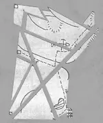
Even though the maps look cheesy in their design, upon close examination, one will soon find tiny notches in the drawn lines across which you lay your ruler. These are penknife cut lines. Some ruler aligned cut points are simply the end of a drawn line that is tapered like the point of a penknife point. The art is similar to Japanese paper folding in format, but all that is necessary is to find the cut lines and then upon cutting the map into pieces, you then over lap the paper pieces cut apart, one on top of each other, begining with the largest piece first, followed by the next smaller piece and so on down to the littlest piece last. The first piece sits in it's original position to start and gives you a base or table to build on. The rest of the pieces must be turned counter clockwise, or at a right angle as the Mason might explain, until you begin to see various marks line up with each other; it is indeed a cool little childlike puzzle that will drive one mad otherwise. Sooner or later, you will have an assembled map showing the finer points at the mine site, as this explains the positions and placement of the markers installed on the ground around the mine(s).
A Don and or a miner follows the water first; generally upstream, looking for float first and soon finds slightly altered and manually placed markers that don't quite look right. These lead from the water, onward to the colours up the tributaries and near to the target in question. Triangulation; from large to small.
It is really very simple; you are working with odd numbers. The map is one piece. Cut it right, and you have three pieces. Get the hang of it and you will see that it can also be cut into 5 pieces and so on. More finite information comes out of them in doing so. On an expert level of the game, you will end up with 8 pieces and an all new master map, even though all you need is a three piece assembly to find the mine.
The code will talk to you in images, as you learn the symbols along the way. Once you begin to learn the symbols used, you will find that the new map you have assembled, can be cut across again or two lines making a cross. Reassembly requires knowledge of the same symbols you have just learned; it explains itself and it's mechanisms all by itself as you go. Even the traps in the mines are built with the same geometry; the system warns you of them and their approximate location underground. Don't feel so lost; this all took me half my life to figure out by back tracking out away from several different mines and caches. BEWARE OF POISONED CACHE SITES!!!!! They will kill you if you are not very, very careful. The idea is to use the cache site position geometry to find the mine and little else.
Twisted Fork
Hero Member
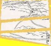
Enclosed is a photo of the first paper map I used in Arizona. The life of the priest who stands by the river. The large knife, the fish and the stone. A catfish fillet. I had already located the mine at this point and back tracked away from it, going marker to marker as they are laid out on the tablets of which I cut my teeth on per say. The second photo is a master map from many years later; Also a Peralta mine elsewhere.
Attachments
Twisted Fork
Hero Member
1847 is simply the end time of their world due to the Mexican American War. The date in the heart, may have not been present until that time. It marks a major tuning point in their existence; "The End of the Dons." Of course there are various other paper maps that are dated up to a later date, but the Arizona site was deemed the Heart of a much larger form.
If you will research the painting styles of early Mexican artists, you will find that one artist in particular used to paint pictures of a Don, leading a long line of peons, dressed in white through the desert. The Don was drawn as an ornately dressed being 80 feet tall, and the peon miners as little tiny men following behind him. Twin Peaks (two boots) in southern Arizona are the boots of the Don; The brim of his hat is Mexican hat in the four corners area. I believe it was later expanded to King's Peak, Utah. This is a map of one big mining site covering hundreds of miles and the funnel pit in Arizona is the position of his heart within this massive drawing of the overall mining site, covering these hundreds of miles. Scale is your deception.
If you will research the painting styles of early Mexican artists, you will find that one artist in particular used to paint pictures of a Don, leading a long line of peons, dressed in white through the desert. The Don was drawn as an ornately dressed being 80 feet tall, and the peon miners as little tiny men following behind him. Twin Peaks (two boots) in southern Arizona are the boots of the Don; The brim of his hat is Mexican hat in the four corners area. I believe it was later expanded to King's Peak, Utah. This is a map of one big mining site covering hundreds of miles and the funnel pit in Arizona is the position of his heart within this massive drawing of the overall mining site, covering these hundreds of miles. Scale is your deception.
Javaone
Full Member
Blindbowman said:Javaone said:I am laughing already!
so am i ...lol
why your laughing do you know what a 1/15,000 scale is .. ?
Please tell me.
So I can laugh some more. SANTA FE NEW MEXICAN
Sr. Member
Twisted Wrote: Much of the confusion here is based on the simple fact that time has forgotten the vast territory that the Peraltas were working with. They worked the very richest mines alone and only earmarked various lodes along the trail. This is why various individuals and authors as well, have become confused as to where one mine or the other is truly located.
They were required to set up their monuments and conceal each of the mines that they wished to retain by title; according to the standards set upon them by the powers that be. 18 feet of tunnel, had to be excavated within three months of their initial discovery or else another Don would be able to put a lean on the dig and take it from them.
The Peraltas field filed claims on a chain of mines that began in Mexico and finished as far North as the tip of Idaho. Their sign can be found in every mining district along the way. Their main red heart stone was located in the Western desert of Utah in 1996, on a now closed gold mine some 50 miles or so North of the old Pony Express station located at Simpson Springs. Early pioneers know as the Danites, found one of their mines around 1847, mined as much as they could carry and headed for present day Mesa, Arizona, tracking the Peraltas down to the placer, miles South of the funnel pit mine.
To this day, the Peralta stone bread trail is still intact surviving lighting strike fires and whatever else that mother nature has dished out since then. Abe Lincoln said himself some years later, that Utah was the treasure house of the nation, after a federally funded expedition of geologists searched the area as they followed the old pack train trails of these illusive Dons and their mining parties.
A now deceased author by the name of George Thompson, worked side by side with Mel Fischer in the search for evidence of the source of gold that was found in the famous shipwreck; Here in Utah, in the Uinta Mnts., gold caches were located near mining sites and chemical tests proved that Utah was indeed involved collectively in the treasures found on the ocean floor.
Right there indeed. It is more probable that Thompson contacted Fischer rather than otherwise. I was in contact with Thompson several days before his unexpected passing; he was sent photo evidence of Carrie Shin Ob, a once lost Ute Gold mine along the trail at Spanish Fork, Utah. Arrangements were being made through his publisher for him to go on site with our crew. This place truly gives one the creeps to say the least. The whole deal scared the crap out of us.
You know the dutchman was a great contributor and even more so the tunnel that was mined over a mile down wind; Spill from the main outcrop. There has been more than one funnel located in Arizona in the last 100 years. Probably all Peralta digs I suppose. Stone and plant markers are generally arranged some 47 to 65 miles apart with this system and the map to the mine one is looking for, is laid out on the ground at the outer edge of the previous mine and thus the confusion, Mnt. to Mnt.site. This is the legend box like you see on todays road maps. Scale changes every time, but the map retains it's format as it is traced, read backwards, inverted, turned at a right angle or counter-clockwise and upside down as well. North is really East as it is drawn and the marker sets are positioned differently as the terrain requires site to site. Fun huh? Well Oh man..... They didn't want us white folk to find them for nothing Simply compare the paper Peralto maps to the tablets and look for comparable shape matching in the graphics, one to the other. You will soon see that they are one in the same art, even if they were done years apart from each other. You guys have got to get it straight in your heads that the Salt River is the key through and through. This is a Masonic code that has been handed down over many, many generations and lodges. It is privileged information shared with royalty and bloodlines there of.
Of course the trail starts in one's mind, from anywhere in the world, in the hands of one who knows where the Holy Land is first located. The quads are enclosed. Lay your ruler across them; The cross of Christ is the key to understanding. Since the tablets were obviously found on the trail, and 1847 is the year of war and death to their secret world in Arizona, What better way to say it than with a headstone; the first and the last is the answer.All of them Beth
Even though the maps look cheesy in their design, upon close examination, one will soon find tiny notches in the drawn lines across which you lay your ruler. These are penknife cut lines. Some ruler aligned cut points are simply the end of a drawn line that is tapered like the point of a penknife point. The art is similar to Japanese paper folding in format, but all that is necessary is to find the cut lines and then upon cutting the map into pieces, you then over lap the paper pieces cut apart, one on top of each other, begining with the largest piece first, followed by the next smaller piece and so on down to the littlest piece last. The first piece sits in it's original position to start and gives you a base or table to build on. The rest of the pieces must be turned counter clockwise, or at a right angle as the Mason might explain, until you begin to see various marks line up with each other; it is indeed a cool little childlike puzzle that will drive one mad otherwise. Sooner or later, you will have an assembled map showing the finer points at the mine site, as this explains the positions and placement of the markers installed on the ground around the mine(s).
A Don and or a miner follows the water first; generally upstream, looking for float first and soon finds slightly altered and manually placed markers that don't quite look right. These lead from the water, onward to the colours up the tributaries and near to the target in question. Triangulation; from large to small.
It is really very simple; you are working with odd numbers. The map is one piece. Cut it right, and you have three pieces. Get the hang of it and you will see that it can also be cut into 5 pieces and so on. More finite information comes out of them in doing so. On an expert level of the game, you will end up with 8 pieces and an all new master map, even though all you need is a three piece assembly to find the mine.
The code will talk to you in images, as you learn the symbols along the way. Once you begin to learn the symbols used, you will find that the new map you have assembled, can be cut across again or two lines making a cross. Reassembly requires knowledge of the same symbols you have just learned; it explains itself and it's mechanisms all by itself as you go. Even the traps in the mines are built with the same geometry; the system warns you of them and their approximate location underground. Don't feel so lost; this all took me half my life to figure out by back tracking out away from several different mines and caches. BEWARE OF POISONED CACHE SITES!!!!! They will kill you if you are not very, very careful. The idea is to use the cache site position geometry to """""""""find the mine and little else."""""""" 1847 is simply the end time of their world due to the Mexican American War. The date in the heart, may have not been present until that time. It marks a major tuning point in their existence; "The End of the Dons." Of course there are various other paper maps that are dated up to a later date, but the Arizona site was deemed the Heart of a much larger form.
If you will research the painting styles of early Mexican artists, you will find that one artist in particular used to paint pictures of a Don, leading a long line of peons, dressed in white through the desert. The Don was drawn as an ornately dressed being 80 feet tall, and the peon miners as little tiny men following behind him. Twin Peaks (two boots) in southern Arizona are the boots of the Don; The brim of his hat is Mexican hat in the four corners area. I believe it was later expanded to King's Peak, Utah. This is a map of one big mining site covering hundreds of miles and the funnel pit in Arizona is the position of his heart within this massive drawing of the overall mining site, covering these hundreds of miles. Scale is your deception. Twisted That is "Very Very Well Stated" Sincerely John V. Kemm
Springfield
Silver Member
- Joined
- Apr 19, 2003
- Messages
- 2,850
- Reaction score
- 1,388
- Golden Thread
- 0
- Location
- New Mexico
- Detector(s) used
- BS
[mod]OFF TOPIC[/mod]
Loke
Hero Member
- Joined
- Mar 24, 2010
- Messages
- 589
- Reaction score
- 1,383
- Golden Thread
- 0
- Location
- Republic of Texas
- Primary Interest:
- All Treasure Hunting
*big sigh* For goodness sake - gizza break!!
I have never used the ignore button before - now I am ... at least then we can seperate the wheat from the chaff.
And yes I know, I'm feeding the beasts again, but at least I will not be able to see the answering rambling ;-)
I have never used the ignore button before - now I am ... at least then we can seperate the wheat from the chaff.
And yes I know, I'm feeding the beasts again, but at least I will not be able to see the answering rambling ;-)
Top Member Reactions
-
 2257
2257 -
 1493
1493 -
 1310
1310 -
 1304
1304 -
 1061
1061 -
 968
968 -
 807
807 -
 654
654 -
 638
638 -
 537
537 -
 530
530 -
 525
525 -
 498
498 -
 487
487 -
 442
442
Similar threads
Users who are viewing this thread
Total: 2 (members: 0, guests: 2)
