The Many Lost Treasures of Mariposa, CA (Photos Added)

merry Christmas and happy new year eagle. good luck to you in your golden endeavors this upcoming year. I hope California is a little warmer than Indiana. it is a tad cold here. god bless you my friend dave
 

merry Christmas and happy new year eagle. good luck to you in your golden endeavors this upcoming year. I hope California is a little warmer than Indiana. it is a tad cold here. god bless you my friend dave
I imagine it's a bit warmer here. Low 30s at night and low 60s during the day. Thank you for the good wishes and My Blessings to you also Brother.

Love and Respect,

Eagle
 

Eagle have a Merry Christmas and a Happy and Prosperous New Year. Hope all goes well for you in 2014. The Mayor
 

I imagine it's a bit warmer here. Low 30s at night and low 60s during the day. Thank you for the good wishes and My Blessings to you also Brother. Love and Respect, Eagle

Merry Xmas Eagle
Getting ready to run some dirt from my last trip out. Mostly test holes I dug in spots. I couldn't run dirt in the field because of my forgetting the battery for the pump. Lol
It's a nice warm day. Possibly 60s-70s. Wearing my shorts. Lol
 

Eagle have a Merry Christmas and a Happy and Prosperous New Year. Hope all goes well for you in 2014. The Mayor
Thank you My Brother!! I hope you had a great Christmas. As for the "Happy and Prosperous New Year", only time will tell. I'm always happy, so now, all I have to do is work on the prosperous. (lol)
 

Merry Xmas Eagle
Getting ready to run some dirt from my last trip out. Mostly test holes I dug in spots. I couldn't run dirt in the field because of my forgetting the battery for the pump. Lol
It's a nice warm day. Possibly 60s-70s. Wearing my shorts. Lol
Thank you for the well wishes Brother!!

We're definately going to have to work on your memory. (lol) (And maybe those shorts). (lol)​
 

ohhhh ok i wondered what bedrock you were talking about, you can see the lines in that material which i've seen in other tailing type dredge piles, you know up in hells hollow they hand stacked rock and its like 10-15 feet deep up there and HELL NO they didnt do it for nothing theres huge placers in that river if i guy could get down to the bedrock. looking at the river below Mountain King mine the waters so low the river is full of boulders all the way to the middle, THATS THE SPOT TO HIT my buddy has 2 claims down there the Bigfoot claims there a mile from mcCabe flats bridge

I will give an update and take pics/video of what we find out friday

I'm using ACME mapper system give that a try eagle

ACME Mapper 2.1
Thanks for the link Brother!!

I would join you, at the river, but since it's the end of the month, as usual I'm about out of gas and definately out of money. (lol)

Good luck on your expedition and looking forward to some awesome photos.
 

Hey Eagle hope the brakes are workin good I cant believe you went over to Briceburg after I left it was cold that day but I hope to see you soon I will let you know when I can make it up.
 

Hey Eagle hope the brakes are workin good I cant believe you went over to Briceburg after I left it was cold that day but I hope to see you soon I will let you know when I can make it up.
Cold?? That's putting it mildly. It was so cold, it would have taken a 6oz nugget to warm me up. But, after sitting for a couple of weeks, I just had to get out for a bit. And you know what? It was well worth it!! (lol)

The brakes are working great, you did a good job!! I'll be looking forward to getting together again.
 

It looks to be a nice weekend coming. Rob and I are going to head down to the Bagby side and work up river toward where Sherlock creek spills into the Merced and work the hills in to the North. Hmm, that looks like a 3 - 5 mile hike. Then, again, Perhaps I should take Mosher from Whitlock along side of Sherlock creek to the Merced. What do you think Eagle?
 

It looks to be a nice weekend coming. Rob and I are going to head down to the Bagby side and work up river toward where Sherlock creek spills into the Merced and work the hills in to the North. Hmm, that looks like a 3 - 5 mile hike. Then, again, Perhaps I should take Mosher from Whitlock along side of Sherlock creek to the Merced. What do you think Eagle?
It sounds good, BUT, once you get down Mosher, you'll find your way blocked by gates. The one to the left, (after the fork) is patented, (private). The one to the right is claimed and the gate is also locked. Both are in areas where it's a little difficult to turn around due to the narrow road. (The one to the left is the hardest).

Believe me, I found all this out, the hard way. (lol)

That's certainly poses a problem for access from that direction. Not that I'm surprised by it. Well, then Bagby looks like the best choice. Coming in from Briceburg lengthens the hike quite a bit. I have a feeling I'm gonna be worn out by the time I'm done.

I see on Google maps, just East of Bagby, past the bend, a creek that spills into the Merced from the north and travels from far up the hill. It looks compelling . But neither Rob nor I have that much knowledge prospecting. So no telling where we will end up. It's either the Merced or the hills around town. Either way, we have to hunt.
Good luck on your hunt/hike! I'm leaving here in a few minutes for Mariposa. I'm thinking about going out Whitlock Rd., to see if I can find an area to metal detect, where I won't get in trouble. (lol)
 

Good luck on your hunt/hike! I'm leaving here in a few minutes for Mariposa. I'm thinking about going out Whitlock Rd., to see if I can find an area to metal detect, where I won't get in trouble. (lol)

Well, if you are going to be in the neighborhood, drop me a line so we can meet up if you are going to be here for a bit.
 

Mariposagold, good luck on your hike. I've been to that inside bend below Sherlock once. Just barely got my boat up to it and it was a long boat ride! Way too low for boat now, I know. If you ever run into Gerry Edwards, he has claims down past the gate on Mosher and therefore keys to gate. Don't know if he'd let someone use the access tho. Someone mentioned possible access from Shilling RD. Will have to check that out.
Shep
 

Just checked Google Earth. There does appear to be a road (trail) on the ridge above that drops down to w/I 1/2 mile of your bend. Don't know if Gestapol has the ground opened yet since fire. Might make a good bike or quad ride. I got dizzy trying to follow road out to see best starting point, but it looks much more appealing than walking from Bagby. Just say'n

Shep
 

Mariposagold, good luck on your hike. I've been to that inside bend below Sherlock once. Just barely got my boat up to it and it was a long boat ride! Way too low for boat now, I know. If you ever run into Gerry Edwards, he has claims down past the gate on Mosher and therefore keys to gate. Don't know if he'd let someone use the access tho. Someone mentioned possible access from Shilling RD. Will have to check that out.
Shep

Yes, any boat going that way right now would require wheels. I haven't met Gerry or much of anyone works the area yet. I was looking at the Schilling road access. Appears challenging. I've been up in that area before, and down dogtown road just scoping it out. The whole area is worth checking out for sure. Given it as the two key element: Dirt and History of Gold. LOL.
 

Just checked Google Earth. There does appear to be a road (trail) on the ridge above that drops down to w/I 1/2 mile of your bend. Don't know if Gestapol has the ground opened yet since fire. Might make a good bike or quad ride. I got dizzy trying to follow road out to see best starting point, but it looks much more appealing than walking from Bagby. Just say'n

Shep

I see that. Coming from Shilling. Looks like it goes right through someones yard. Bike or quad is out of the question since I have neither. If I'm just going to that bend, it should be that bad. The trek to Sherlock would be a big pain, I'm thinking. I always get dizzy following those trails on the map.
 

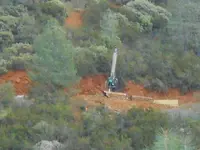
Ok so we took a quick run up to Bagby stopping along the way to admire all the NO TRESSPASSING FREMONTS signs along the bagby grade road and the drill rig up on the Josephine mine, I will post a blurry picture of that.

We worked the river a bit down below the bridge finding little gold, tough digging in those boulders and impossible at times without crow bar and THIS is why we dredge, other wise its not worth the time and effort it takes to get to bedrock, I hate hate this kind of digging instream, im to friggin old LOL.

I had good conversations with several prospectors down there great friendly people who gladly showed some of there fines, and they were fine no real pickers even but nice size flakes,,, slim pickins they had for there labors but they were happy to get a little gold regardless.

Bagby road is now CLOSED so no access to camp ground areas or the primitive area, you will have to hike back probably on the old train railroad on north side of river, I hope someone trys the schilling road access to see if theres a way down, I have much doubt but it may be possible.

The river is so low its not even knee deep in most places, havent ever seen it quite this low this time of year.

Above the grade road we pull off a dirt road, no barb wire fence in this spot, we drive back 200 feet and BOOM NO TRESSPASSING FREMONTS sign LOL I had to laugh, they obviously have decided to take control again of there granted land that they bought , 44,000 acres for $3,280.00 back in 1846 which i guess the family still owns, how about that load of sh$%
Heres that story for you to read a bito history

https://www.thecivilwardays.com/Las_Mariposas_Land_Grant.html

Josephine mine drill rig
Picture 120.jpg


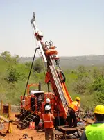
This is the type of drill rig up there...
Drill Rig 350.png
 

Top Member Reactions

Users who are viewing this thread

Latest Discussions

Back
Top